NH Snow Cover Extent
| October 2016 | Snow Cover Extent | Anomaly 1991-2020 | Trend per decade | Rank (49 years) | Record | ||||||
|---|---|---|---|---|---|---|---|---|---|---|---|
| million km² | million mi² | million km² | million mi² | million km² | million mi² | Year(s) | million km² | million mi² | |||
| Northern Hemisphere | 22.95 | 8.86 | +3.78 | +1.46 | +0.32 | +0.12 | Largest | 3rd | 1976 | 25.72 | 9.93 |
| Smallest | 47th | 1988 | 12.78 | 4.93 | |||||||
| North America | 9.47 | 3.66 | +0.99 | +0.38 | +0.11 | +0.04 | Largest | 2nd | 2002 | 9.76 | 3.77 |
| Smallest | 48th | 1979 | 6.36 | 2.46 | |||||||
| Eurasia | 13.48 | 5.20 | +2.80 | +1.08 | +0.21 | +0.08 | Largest | 3rd | 1976 | 17.22 | 6.65 |
| Smallest | 47th | 1988 | 5.58 | 2.15 | |||||||
Data Source: Global Snow Laboratory, Rutgers University. Period of record: 1967–2016 (49 years)

The Northern Hemisphere snow sover extent (SCE) for October 2016 was 22.95 million square km (8.86 million square miles), which is 5.41 million square km (1.09 million square miles), or 30.9 percent, larger than the 1981-2010 average. This was the third largest October SCE in the 49-year period of record for the Northern Hemisphere. Each of the last five Octobers, beginning with October 2012, has seen above-average Northern Hemisphere SCE values. October's long term trend (since 1967) is +1.3% more SCE per decade, the largest such upward trend of any month.
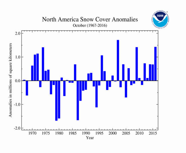
The October North American SCE was 9.42 million square km (3.66 million square miles), 1.42 million square km (550,000 square miles) above average and the 2nd largest on record, behind only October 2002. Snow cover was above average over much of Canada, and below average in nearly all U.S. locations which can have snow cover in October. Because the Canadian footprint dominates the U.S. footprint this early in the snow season, surpluses in Canada far outweighed deficits in the United States.
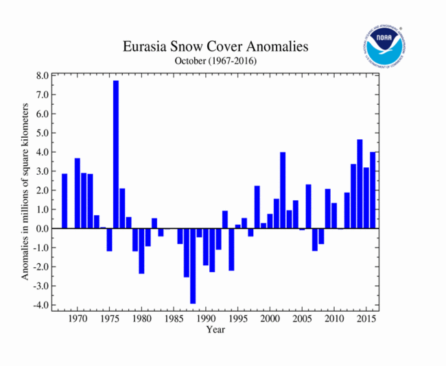
The Eurasian SCE during October was 13.48 million square km (5.21 million square miles), which is 3.98 million square km (1.54 million square miles) above average. This was the third largest October SCE on record for Eurasia. Above-average SCE was observed across much of Asia, and was particularly so across the Eurasian Steppe. Below-average snow cover was observed across the Tibetan Plateau, parts of Russia's western Arctic coast, and in the easternmost Russian Far East.
Sea Ice Extent
| October 2016 | Sea Ice Extent | Anomaly 1991-2020 | Trend per decade | Rank (38 years) | Record | ||||
|---|---|---|---|---|---|---|---|---|---|
| million km² | million mi² | Year(s) | million km² | million mi² | |||||
| Northern Hemisphere | 6.08 | 2.35 | -18.83% | -10.15% | Largest | 36th | 1986 | 9.48 | 3.66 |
| Smallest | 3rd | 2012 | 5.89 | 2.27 | |||||
| Southern Hemisphere | 17.46 | 6.74 | -4.22% | +0.93% | Largest | 37th | 2013 | 19.02 | 7.34 |
| Smallest | 2nd | 1986 | 17.18 | 6.63 | |||||
| Globe | 23.54 | 9.09 | -8.48% | -2.29% | Largest | 38th | 1980 | 27.75 | 10.71 |
| Smallest | 1st | 2016 | 23.54 | 9.09 | |||||
Data Source: National Snow and Ice Data Center (NSIDC). Period of record: 1979–2016 (38 years)

According to the National Snow and Ice Data Center (NSIDC), the Northern Hemisphere (Arctic) sea ice extent — which is measured from passive microwave instruments onboard NOAA satellites — averaged for October 2016 was 6.39 million square km (2.47 million square miles), which was 2.55 million square km (980,000 square miles), or 28.5 percent, below the 1981-2010 average. This was the smallest October Arctic sea ice extent on record, and was 690,000 million square km (260,000 square miles) smaller than the previous smallest October Arctic sea ice extent in 2012. Basinwide, October started with anemic sea ice growth during the first half of the month, much slower than is typical during the period, with daily values increasingly near record small during the stretch. This was followed by a ten-day period with sea ice expansion more typical of the month, then the month's final week again showed very slow growth, and even some contraction. By the 20th, daily values were record small, and by month's end the monthly average had dipped to a record low as well. Arctic sea ice extent is decreasing at a rate of approximately 7.3 percent per decade.

Regionally, below-average sea ice was especially evident on the Pacific side of the Arctic, in the seas off the Arctic coasts of western North America (Beaufort, Chukchi) and eastern Russia (Eastern Siberian, Kara). The NSIDC Analysis notes that the areas of most stagnant growth during October were the southernmost reaches that had anomalously warm sea surface temperatures. These warm SSTs were, in turn, related to the early retreat of sea ice from these southern reaches earlier in the season, which exposed those areas to late summer solar insolation that added even more heat to the area, relative to historical norms. This situation is representative of a "positive feedback" or "reinforcing" cycle common to the Arctic climate system, in which large-scale warming leads to effects that further reinforce warming.

The October Southern Hemisphere (Antarctic) sea ice extent was 17.62 million square km (6.81 million square miles), which was 740,000 square km (290,000 square miles), or approximately 4.0 percent, below the 1981-2010 average. This was the second smallest October Southern Hemisphere sea ice extent on record, approximately 20,000 square kilometers (slightly less than 10,000 square miles) larger than the record-small October value set in 1986. Southern Hemisphere October sea ice extent is increasing at an average rate of approximately 0.9 percent per decade, with some inter-annual variability.

October typically is the first full calendar month of sea ice retreat in the Southern hemisphere. October 2016's day-to-day sea ice retreat was more rapid than the historical norms for the month. This, combined with a precipitous drop in mid-September, has repositioned 2016's Antarctic sea ice extent below the roughly near-normal position evident throughout most of the year to date.
For further information on the Northern and Southern Hemisphere snow and ice conditions, please visit the NSIDC News page.