Issued: 10 January 2011
Sea Ice Extent
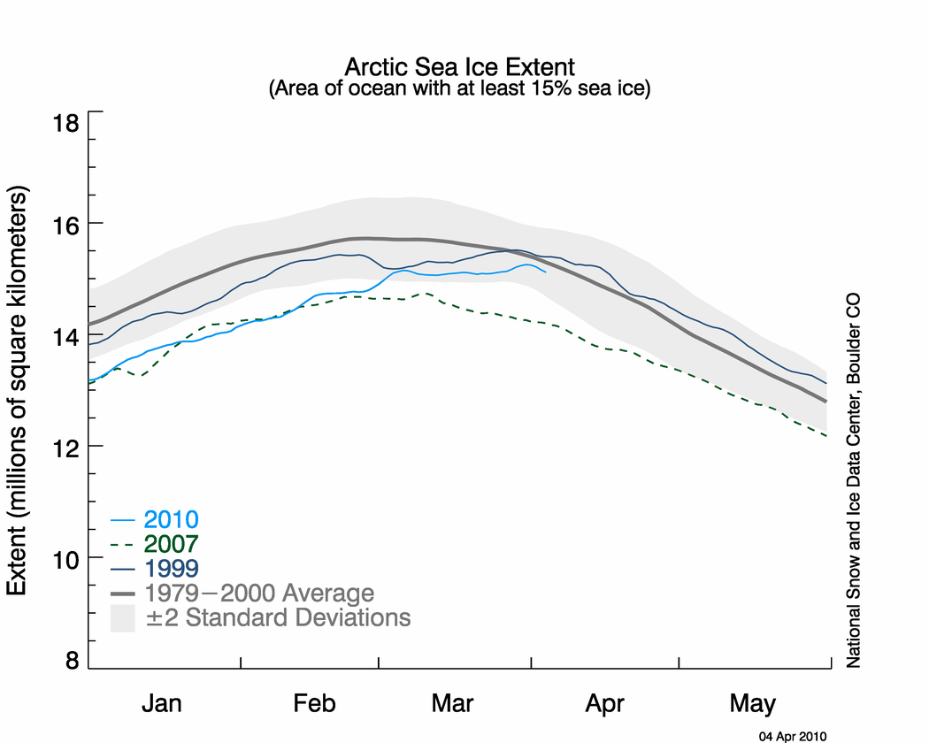
Arctic sea ice extent, which is measured from passive microwave instruments onboard NOAA satellites, usually expands during the cold season to a March maximum, then contracts during the warm season to a September minimum. According to the NOAA supported National Snow and Ice Data Center, the maximum Arctic sea ice extent during 2010 occurred on March 31st — the latest date for the maximum sea ice extent since records began in 1979. The previous record for latest date was set on March 29th, 1999. On March 31st the maximum extent was 15.25 million square km (5.9 million square miles). This was 670,000 square kilometers (260,000 square miles) above the record low maximum extent, which occurred in 2006.
September Arctic Sea Ice 1979-2010
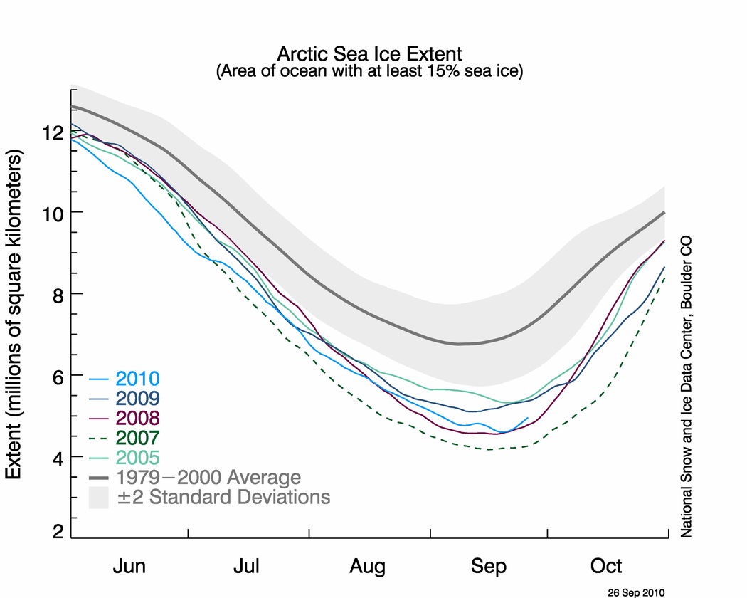
According to the NSIDC, the minimum Arctic sea ice extent during 2010 occurred on September 19th, at 1.78 million square miles (4.6 million square km) marking the third smallest extent on record. The 2010 annual minimum extent was 14,000 square miles (37,000 square km) larger than the minimum extent in 2008 and 181,000 square miles (470,000 square km) larger than the minimum extent in 2007. According to the National Ice Center, both the Northwest Passage and the Northern Sea Route were ice free during September. This is the first time in modern history that both Arctic Sea routes have been open for navigation. The monthly average Arctic ice extent during September was 1.89 million square miles (4.9 million square km). The monthly extent was 30.4 percent below the 1979–2000 average and ranked as the third smallest September Northern Hemisphere sea ice extent in the satellite record, behind 2007 (lowest) and 2008 (second lowest). An additional NOAA animation of the 2010 Arcitc sea ice minimum can be found at NOAA's Environmental Visualization Laboratory.
Sea ice conditions in the Antarctic were significantly different than conditions across the Arctic during 2010. The Antarctic sea ice extent usually expands during the cold season to a September maximum, then contracts during the warm season to a March minimum. Unlike the two previous years which were above average, the March 2010 Southern Hemisphere sea ice extent was 6.9 percent below the 1979–2000 average. This was the eighth smallest sea ice extent in March. By September, the Antarctic sea ice had grown significantly compared to the minimum extent in March. The September extent was 7.4 million square miles (19.16 square km) and was the third largest September extent on record behind 2006 and 2007.
For further information on the Northern and Southern Hemisphere snow and ice conditions, please visit the NSIDC News page, provided by NOAA's National Snow and Ice Data Center (NSIDC).
NH Snow Cover Extent
Analyses of NOAA data were provided by the Global Snow Laboratory, Rutgers University. Period of record is 1967-2010 (44 years).
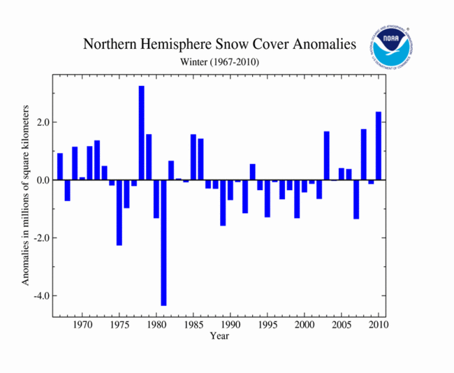
The time series to the right shows the mean Northern Hemisphere snow cover extent for winter 2009-2010 (Dec–Feb) was much above average, and the second largest extent in the 44–year period of record. The seasonal average extent of 47.5 million square km (18.3 million square miles) was 2.4 million square km (0.9 million square miles) above the long term average. The largest Northern Hemisphere winter snow cover extent occurred during the 1977–1978 winter season. More information on individual Northern Hemisphere snow storms can be found in the Global Hazards report.
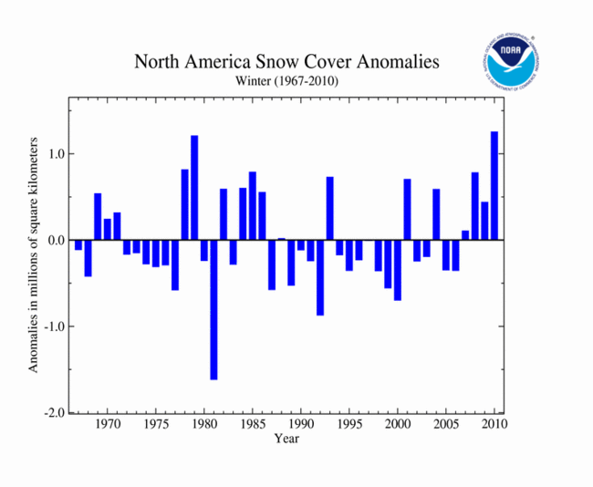
Across North America during the 2009–2010 winter, snowfall was widespread. Snow fell in all 48 states of the contiguous United States. This contributed to the North American snow cover extent for the 2009-2010 winter season being the largest in the 44–year satellite record. The seasonally–averaged snow extent of 18.3 million square km (7.1 million square miles) was 1.3 million square km (500,000 square miles) above the long term average — nearly twice the size of the state of Texas. Please see the U.S. Cold Season Special Report for more information on the winter season across the United States.
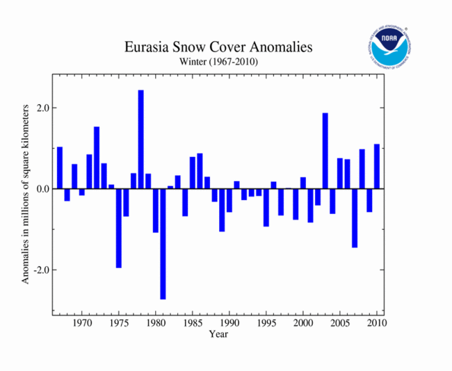
In Eurasia, snow cover extent during the 2009–2010 winter was 29.2 million square km (11.3 million square miles), which is also above average. The snow cover extent was 1.1 million square km (425,000 square miles) above the long–term average, ranking as the fourth largest winter extent on record.
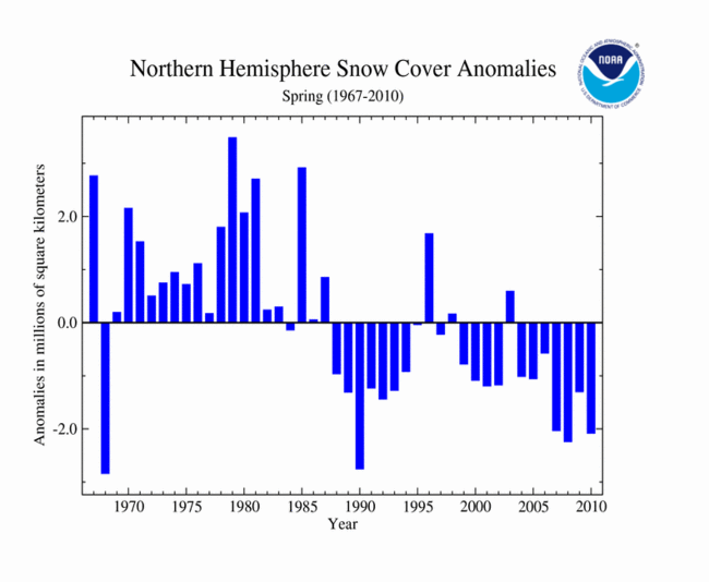
The spring of 2010 brought very different conditions to the Northern Hemisphere than did the winter and that is represented by the changes in the snow cover extent, which was much below average — fourth smallest spring snow cover extent on record. The spring snow cover extent was 2.1 million square km (810,000 square miles) below average. This was the 7th consecutive spring with below average snow cover extent for the hemisphere, and only three springs since 1990 have had above average snow cover extent.
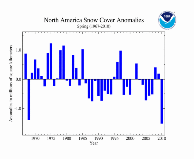
Across North America, spring was also significantly different than the winter. The spring snow cover extent was 11.2 million square km (4.3 million square miles) — 1.5 million square km (580,000 square miles) below the long term average. This value ranked as the smallest spring snow cover extent in the 44–year period of record. This is in contrast to the largest winter snow cover extent on record just months prior.
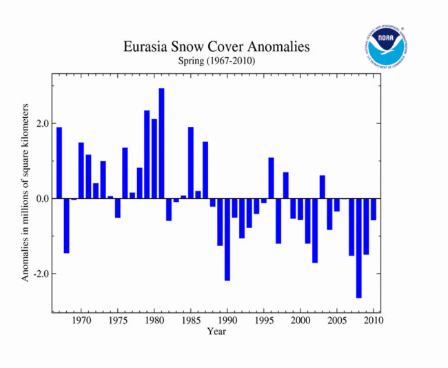
The spring Eurasian snow cover extent was also smaller than normal during 2010 at 0.6 million square km below average (230,000 square miles). Spring 2010 ranked as the 14th smallest (31st largest) Eurasian snow cover extent in the 44–year period of record.