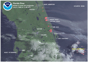
 Florida Fires
An unusually wet and mild winter associated with mature El
Niño conditions promoted abundant under-brush growth in
Florida. Beginning in the spring a persistent subtropical high
pressure suppressed rain for several months. Severe drought
conditions ensued in May and June, and the under-brush allowed wild
fires to spread across much of the state. This multi-channel
satellite image, taken on July 2, shows numerous fires on a
line from Saint Augustine to Titusville Florida. The red spots are
hot spots detected by one of the sensors. The areas on fire are
actually smaller than these hot spots.
| Forest Fires
in Eastern Russia |
| High pressure
persisted from May through September over eastern Russia. The large
area of high pressure forced the jet stream southward over China,
leaving eastern Russia, including Sakhalin Island without adequate
rainfall. Several months of below normal rainfall created a severe
drought. |
| The extremely dry
conditions allowed hundreds of forest fires to burn out of control
for many weeks. This satellite image, taken on August 2 by NOAA-12,
vividly shows many large forest fires with streaks of smoke blown
across Alaska and western Canada by the prevailing westerlies. |

larger image |
| Sub-tropical high
pressure settled over the region early in the spring season causing
dry conditions throughout much of Central America and the southern
third of the United States. As farmers in Mexico set fires to clear
new lands for crop plantings, the extremely low moisture content of
the surrounding vegetation made it difficult to control the fires.
As a result, several large areas of wildfire developed. |

larger image |
This satellite image,
taken by GOES-8, is a multispectral, false color composite which
shows smoke and haze in yellow tones and hot spots in red tones.
The smoke is seen spreading northward into the western Gulf of
Mexico and into southern Texas where visibility was reduced to less
than 2 miles. |
| Dry conditions
associated with mature El Niño conditions last winter is
partially to blame for the widespread fires in many parts of
Brazil. Many of the fires were started by farmers and loggers
clearing land and spread as extremely dry conditions made it
difficult to control their size. |
| On some days, GOES
satellites captured several thousand fires burning simultaneously.
The resultant smoky plumes covered millions of square miles and
affected the health of many farmers and native peoples . This
multispectral satellite image was taken on July 28 over the
province of Mato Grosso in southwestern Brazil. |

larger image |

larger image |
As is typical during
mature El Niño conditions, the monsoon rains over Indonesia
were greatly depressed from June 1997 through May 1998. As a
result, Indonesia experienced one of the worst fire outbreaks ever
recorded. Smoke traveled for thousands of miles, affecting millions
of people. |
| This satellite image,
taken by the Japanese GMS satellite on April 7, 1998, is a
multi-spectral composite. The image reveals a general smoky haze
over much of the region (yellow tones). |

NOAA's National Climatic Data Center is the world's largest
active archive of weather data. The preliminary temperature and
precipitation rankings are available from the center by calling:
828-271-4800 or on the World Wide Web at: Climate at a Glance.
NOAA works closely with the academic and science communities on
climate-related research projects to increase the understanding of
El Niño and improve forecasting techniques. NOAA's Climate
Prediction Center monitors, analyzes and predicts climate events
ranging from weeks to seasons for the nation. NOAA also operates
the network of data buoys and satellites that provide vital
information about the ocean waters, and initiates research projects
to improve future climate forecasts. The long lead climate outlooks
are available on the Internet at: https://www.cpc.ncep.noaa.gov/products/predictions/90day/.
Additional Links
Additional Links


 NOAA's National Centers for Environmental Information
