LA NIÑA CONDITIONS CONTINUE IN
THE EQUATORIAL PACIFIC
|
|
Sea-Surface
Temperatures (SSTs) and
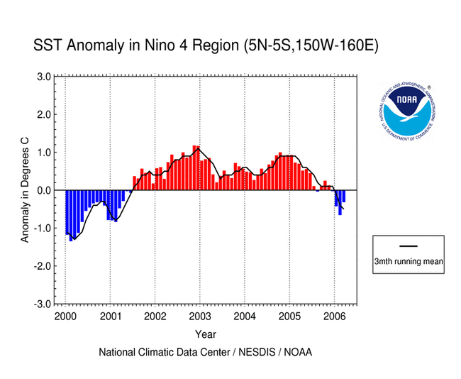
Mixed-Layer Conditions: SSTs remained below average across most of the equatorial Pacific Ocean this past month. The observed SST anomalies during March were below the long-term means in the central parts of the tropical Pacific basin. In contrast, across the eastern Pacific the observed SST anomalies have been above normal but decreased to near-normal by the end of the month in the Niño 1+2 region. In the mixed-layer, below average water temperatures remained in the eastern and central Pacific, with the largest monthly anomalies of -2°C centered near 120°W and at ~50-200 m depth. For the month, the SST anomaly in the Niño 3.4 Index region was -0.59°C (-1.06°F). The western Pacific SSTs increased slightly during March, with a monthly averaged Niño 4 Index of -0.31°C (-0.56°F) (map of Niño regions). For the most recent ocean surface temperature conditions, please see the loop of satellite-derived weekly SST anomalies for March 2006. Below average SST anomalies persisted throughout the latter half of 2005 and into the first three months of 2006 in the central equatorial Pacific basin, and this can be seen in the data from NCDC's Extended Reconstructed Sea Surface Temperature dataset (ERSST version 2). Due to the persistence of the below average SSTs, the 3-month running mean of the Niño 3.4 region remained below -0.5°C in March. (NOTE: A running 3-month mean SST anomaly below -0.5°C in the Niño 3.4 region is one indicator that a La Niña is occurring. For NOAA's official ENSO classification scheme, please see NOAA's El Niño/La Niña Index Definition and also see the CPC ENSO Diagnostic Discussion for NOAA's latest official assessment of ENSO conditions.) |


|
|
Equatorial Zonal Winds (U-Component
Winds) and Sea-Level Topography: The easterly trade winds were above normal across the central and western equatorial Pacific basin during March, with the largest anomalies of 1 m/s near the Date Line. These stronger-than-average trade winds increased equatorial upwelling in the mixed-layer, which maintained the observed colder-than-average SSTs in both the Niño 3.4 and 4 regions. Satellite altimetry of ocean surface topography from the NASA/JPL Jason-1 satellite over the Pacific basin and global oceans is shown to the left. As of April 10th the satellite data from March are currently unavailable. However, the most recent Pacific overpass of the Jason-1 satellite showed a number of large positive sea level anomalies in the southwest and northwest Pacific, most likely associated with enhanced tropical convection. Negative anomalies that were measured in the central equatorial Pacific during February were directly related to the cold SSTs associated with La Niña conditions (see the 17 February 2006 overpass). |


|
|
Outgoing
Longwave Radiation (OLR): The map to the left shows the spatial pattern of global OLR (in W m-2) observed by satellite during March. Positive OLR anomalies (typically associated with La Niña) have persisted over the past several months in the equatorial western Pacific region, centered near the Date Line, and tropical convection was again suppressed just north of the equator in the central and eastern Pacific this past month. The 3-month averaged OLR anomalies were also positive in the western Pacific basin near the Date Line. In contrast, enhanced tropical convection was observed farther west in Indonesia and the maritime continent region. The negative OLR anomalies over parts of Australia were associated with several tropical cyclones that impacted this region during the past month (for more information please go to the Tropical Cyclones section of the March Global Hazards page). The monthly-averaged OLR Index remained positive during March, with a value of +0.6 W m-2 averaged across an area centered over the Date Line in the western Pacific between 160° E and 160° W (note that positive OLR Index values are typically associated with La Niña conditions in this region). March was the eighth consecutive month with a positive OLR Index, a period which coincided with the development of weak La Niña conditions and the persistence of below average SSTs in the mixed-layer in the equatorial Pacific. Note that high frequency variability in OLR is typically associated with the Madden-Julian Oscillation (MJO, which is convective activity that propagates west to east in the near-equatorial region from the Indian Ocean into the Pacific Ocean approximately every 30-60 days). The latest MJO activity can be seen in CPC's graphs of Daily MJO Indices. |
 Larger image of
March OLR
Larger image of
March OLR Larger image
of Jan-Mar OLR
Larger image
of Jan-Mar OLR Larger image of March
OLR Index
Larger image of March
OLR Index| Southern Oscillation Index
(SOI): The standardized SOI switched signs from a negative to a positive index in March, with an average value of +1.4 for the month. The SOI has shown no persistent signal during the current weak La Niña event, and it has fluctuated several times between a near-neutral value and both positive and negative indices. Therefore, the SOI value in March suggests that moderate air-sea coupling has developed over parts of the Pacific basin in response to the weak La Niña and the associated cool ocean temperatures. |

Additional Links
- ENSO Monitoring
- NOAA El Niño / La Niña Index Definition
- NOAA's Pacific Marine Environmental Laboratory (PMEL):
- NOAA's Climate Prediction Center (CPC):
- NOAA's Physical Science Laboratory
- NASA/JPL Ocean Surface Topography from Space
- Australian Bureau of Meteorology (BoM) Climate Driver Update
- IRI - International Research Institute