SSTs CONTINUE TO COOL IN THE EASTERN EQUATORIAL PACIFIC
|
|
Sea-Surface
Temperatures (SSTs) and
Mixed-Layer Conditions: Since April 2005, the SSTs across the equatorial Pacific Ocean have cooled in the different Niño regions. The coldest anomalies have developed along the South American coast, as reflected in the SST observations from the Niño 1+2 region. Temperatures in the upper ocean and mixed-layer have also decreased, as a layer of anomalously cold water (~1 to ~2°C below normal) has persisted between 50-200 m depth in the central and eastern equatorial Pacific. For the monthly means, the November SST anomaly was -0.49°C (-0.88°F) in the Niño 3.4 Index region in the central equatorial Pacific Ocean, and +0.12°C (+0.22°F) in the Niño 4 Index region in the western equatorial Pacific Ocean (map of Niño regions). For the most recent ocean surface temperature conditions, please see the loop of satellite-derived weekly SST anomalies for November 2005. The monthly SST anomalies in the Niño 3.4 region have exceeded +0.5°C only during April of this year, after which the 2004-2005 ENSO warm event dissipated. At the end of November 2005, the 3-month running mean of the Niño 3.4 Index continued to decrease below the long term mean. (NOTE: A running 3-month mean SST anomaly above +0.5°C in the Niño 3.4 region is one indicator that an El Niño is occurring. For the official NOAA classification scheme, please see NOAA's El Niño/La Niña Index Definition and see the CPC ENSO Diagnostic Discussion for NOAA's latest official assessment of ENSO conditions). |


|
|
Equatorial
Zonal Winds (U-Component Winds) and Sea-Level
Topography: The easterly trade winds remained above-normal during November across the near-equatorial Pacific, which enhanced equatorial upwelling in the mixed-layer. Monthly zonal wind anomalies exceeding 1 m/s were observed along the equator in the eastern Pacific region. In the western equatorial Pacific basin, anomalous westerly winds that were present at the beginning of the month relaxed and stronger than average easterly trade winds developed west of the dateline by mid-November (see the November zonal wind loop). Satellite altimetry of ocean surface topography from the NASA/JPL Jason-1 satellite over the Pacific basin and global oceans are shown to the left. A recent overpass of the Jason-1 satellite on October 29th showed no large-scale sea-level anomalies were present in the equatorial Pacific. However, increased sea levels associated with lower atmospheric pressure and tropical convection were observed just south of the equator along the South Pacific Convergence Zone (SPCZ). |


|
|
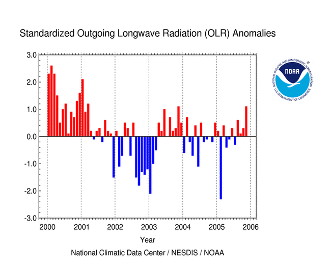
Outgoing
Longwave Radiation (OLR): The map to the left shows the spatial pattern of global OLR (in W m-2) observed by satellite during November. No large-scale OLR anomalies (positive or negative) were observed along the equator or within the equatorial region in the eastern tropical Pacific over the past month. In the western Pacific positive OLR anomalies, associated with suppressed convection, were observed near the dateline, while enhanced convection and negative OLR anomalies were observed over Indonesia. During the September-November period a large east-west oriented region of positive OLR anomalies was observed immediately north of the equator along the Inter-Tropical Convergence Zone (ITCZ) , and therefore tropical convection was anomalously below average in the central and eastern equatorial Pacific during the past 3 months. The monthly averaged OLR Index remained postive in November, with a mean value of +1.1 averaged across an area centered over the dateline in the western Pacific (between 160° E and 160° W). The OLR Index has shifted sign several times over the past year, although the index has been positive for the past 4 months. Note that high frequency variability in OLR is typically associated with the Madden-Julian Oscillation (MJO) (MJO related convective activity propagates west to east in the near-equatorial region from the Indian Ocean into the Pacific Ocean approximately every 30-60 days). The latest MJO activity can be seen in CPC's graphs of Daily MJO Indices. |


| Southern
Oscillation Index (SOI): The standardized SOI decreased in November, with a monthly averaged index value of -0.3. So far in 2005, the SOI has been negative during 6 months, although it switched signs several times with no definitive longer-term trend. However, since March of this year the SOI has remained either neutral or near-neutral, which reflects the lack of any large-scale fluctuations in mean sea-level pressure (MSLP) across the tropical Pacific basin. |

Additional Links
- ENSO Monitoring
- NOAA El Niño / La Niña Index Definition
- NOAA's Pacific Marine Environmental Laboratory (PMEL):
- NOAA's Climate Prediction Center (CPC):
- NOAA's Physical Science Laboratory
- NASA/JPL Ocean Surface Topography from Space
- Australian Bureau of Meteorology (BoM) Climate Driver Update
- IRI - International Research Institute