|
Contents Of This Report: |

|
National Drought Overview
|
|
[top]
Detailed Drought Discussion
Overview
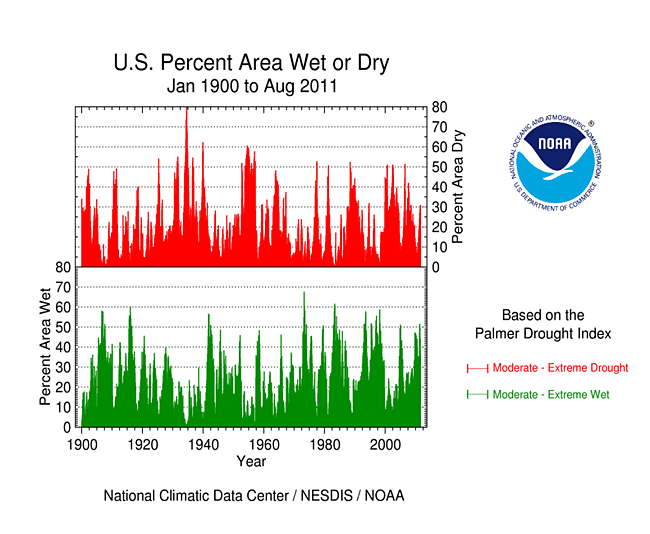
August 2011 was a warm and dry month (second warmest and 27th driest, based on data back to 1895) when weather conditions are averaged across the country. The anomalous warmth was widespread across the country with the greatest anomalies in the southern states, while the precipitation pattern reflected regional extremes on a spatial basis. Both the temperature (weeks 1, 2, 3, 4) and precipitation (weeks 1, 2, 3, 4) anomaly patterns were fairly consistent through time. Continued hot and dry weather expanded drought in the Midwest and intensified the record drought in the Southern Plains, but abundant rainfall contracted drought in the Northeast. While earlier droughts are unsurpassed in terms of duration, the current drought in parts of the South is more intense when measured by the Palmer Hydrological Drought Index. USDM statistics rated 86 percent of the South and 55 percent of the Southeast in moderate to exceptional drought at the end of August. Extreme drought expanded from 47 percent of the Southern Plains at the end of July to 54 percent at the end of August, while in Hawaii moderate to severe drought expanded from 21 percent to 43 percent. The southern drought was accompanied by dessicated soils, failed crops, and hot temperatures, with more than 4800 daily high temperature records and nearly 5500 warm daily low temperature records tied or broken. These hot temperatures intensified evapotranspiration. At the end of August, "exceptional" drought (D4) held steady at about 11 percent of the contiguous U.S., maintaining the summer record (largest national footprint of D4 in the 12-year history of the USDM). About a third of the contiguous U.S. was experiencing moderate to exceptional (D1-D4) drought by August 30th, about the same as at the end of July.
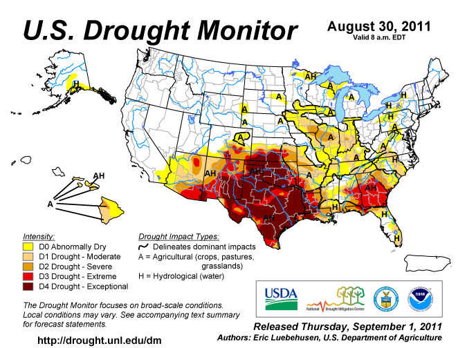
The U.S. Drought Monitor drought map valid August 30, 2011.
By the end of the month, the core drought areas in the U.S. included:
- a large area of moderate (D1) to exceptional (D4) drought across the Southwest, Southern and Central Plains, and into the Lower Mississippi Valley;
- areas of moderate to extreme drought in the Southeast;
- areas of moderate to severe (D2) drought in the Midwest; and
- parts of Hawaii, where moderate to severe drought persisted.
Palmer Drought Index
|
 |
The Palmer drought indices measure the balance between moisture demand (evapotranspiration driven by temperature) and moisture supply (precipitation). The Palmer Z Index depicts moisture conditions for the current month, while the Palmer Hydrological Drought Index (PHDI) and Palmer Drought Severity Index (PDSI) depict the current month's cumulative moisture conditions integrated over the last several months. As seen on the August 2011 Palmer Z Index map, areas of low precipitation and widespread hot temperatures resulted in short-term drought across much of the Southwest to Southeast, Midwest, and western Great Lakes this month. Wet conditions are evident on the Z Index map over a large area from the Mid-Atlantic Coast to the Northeast, and parts of the Central to Northern Plains. Compared with the July 2011 PHDI map, the August 2011 PHDI map indicates that drought conditions intensified in parts of the Southwest, Southern Plains, and Southeast; moist conditions decreased in the Midwest to western Great Lakes; drought conditions decreased along the Mid-Atlantic Coast; and moist conditions increased in the Northeast. The August 2011 PHDI map also reflects the long-term nature of the drought conditions. The Z Index and PHDI maps in combination show that tropical rains brought relief to the Mid-Atlantic and Northeast drought areas, and hot, dry weather dried out the Ohio Valley, but for the Plains to Southeast — it rained where it was already wet and was drier than normal over the existing drought areas.
Standardized Precipitation Index
 |
 |
 |
The Standardized Precipitation Index (SPI) measures moisture supply. The SPI maps here show the spatial extent of anomalously wet and dry areas at time scales ranging from 1 month to 24 months. Dryness is evident across much of the Southwest to Southeast at the 1 month to 12 month time scales (with some indication even at 24 months), and in parts of the Northwest and Ohio and Tennessee valleys at 1 to 2 months. The Central Gulf Coast is wet at 2 months, but dryness is evident at most other time scales from 1 to 12 months. A large area of exceptional dryness is visible in the Southern Plains at 2 months, but it is most evident at 6 to 9 months. Wet conditions are evident in the Northeast and portions of the Northern and Central Plains and California at 1 to 3 months. Widespread wetness dominates the West to Northern Plains, and the Ohio Valley to Northeast, beginning at 6 months. This illustrates the persistence of the dry and wet areas.
 |
 |
 |
Agricultural and Hydrological Indices and Impacts
 |
 |
Drought conditions were reflected in numerous agricultural, hydrological, and other meteorological indicators, both observed and modeled. Across the drought area from the Southwest to portions of the Northeast, streamflows were low, some groundwater well stations were at or near record low levels for this time of year, soil moisture was depleted, water restrictions were implemented in many communities, and pastures, rangeland, crops, and natural vegetation were ravaged. Parts of the Southern Plains, Midwest, and Far West had few, if any, days with rain in August. A large area of dry soils was indicated for Mexico connected to the Southern Plains dryness. The excessive heat across the southern U.S. increased evaporation and placed additional stress on vegetation across much of the country. This summary is based on the following observed and modeled indicators:
hydrological:

USGS groundwater map.
- USGS (U.S. Geological Service) observed streamflow;
- NOAA Climate Prediction Center (CPC) modeled runoff anomalies and percentiles;
- VIC (University of Washington Variable Infiltration Capacity macroscale hydrologic model) 1-, 2-, 3-, and 6-month runoff percentiles;
- NLDAS (North American Land Data Assimilation System) modeled streamflow anomalies and percentiles;
- NLDAS model runoff anomalies and percentiles;
- USGS groundwater observations (real-time network, climate response network, total active network);
agricultural:

VegDRI (Vegetation Drought Response Index) map.
- USDA (U.S. Department of Agriculture) observed soil moisture conditions, departures and percentiles, and comparison to 5-year average and 10-year average;
- the Palmer Crop Moisture Index (CMI), which worsened and expanded during the month in the southern, western, and Midwestern areas (weeks 1, 2, 3, 4);
- CPC modeled soil moisture anomalies and percentiles for end of August, soil moisture anomaly change;
- CPC's Leaky Bucket model soil moisture percentiles;
- NLDAS modeled soil moisture percentiles for the top soil layer and total soil layer;
- VIC modeled soil moisture percentiles and soil moisture percentile change;
- USDA observed pasture and rangeland conditions;
- Vegetation Drought Response Index (VegDRI);
- the NESDIS satellite-based Vegetation Health Index (VHI);
- the USGS agro-hydrologic model (Soil Water Index, Water Requirement Satisfaction Index);
meteorological:

Map of maximum consecutive dry days.
- rainfall observations (plotted by the USGS and NOAA National Weather Service [NWS]);
- percent of normal precipitation and precipitation percentiles (NWS, High Plains Regional Climate Center station observations, Leaky Bucket model, CPC);
- USGS number of days with precipitation and maximum number of consecutive dry days;
- temperature departures from normal and percentiles (CPC, Leaky Bucket);
- number of record warm daily low temperatures, record daily high temperatures, record monthly high temperatures, and all-time record high temperatures set in August 2011 (from NCDC's daily records analysis).
![NOAA National Weather Service [NWS]](/img/climate/research/2011/aug/nws-ahps-pcp-amt-0901-us-aug11.jpg)
Regional Discussion
August 2011 was mostly wetter than normal across Alaska, giving the month a rank of ninth wettest August in the 1918-2011 record. Some interior stations were drier than normal at 2 and 3 months, but more widespread dryness was evident at longer time scales (6, 12, and 24 months). August monthly streamflow was near normal. The August 30th USDM map had an eighth of the state in the abnormally dry category.
Rain from tropical systems gave Puerto Rico a wetter than normal August. Above-normal-rainfall in recent months has resulted in wet conditions at the longer time scales (2, 3, and 6 months, year to date, and water year to date [October-July]). Streamflow was much above average and the August 30th USDM map had no drought or abnormally dry areas on the island.
![water year to date [October-July]](/img/climate/research/2011/aug/nws-ahps-pcp-pct-0831-pr-wytd.jpg)
Most of the stations in the Hawaiian Islands were drier than normal during August. Drought conditions expanded during the month, increasing from 21 percent of the state in moderate to severe drought at the end of July to 43 percent at the end of August. For the southern islands, long-term rainfall deficits remained at most time scales (last 2, 3, 6, 12, 24 months). SPI values were dry at many stations, especially in the southern islands, for several time scales (1, 3, 12, and 24 months).
 |
 |
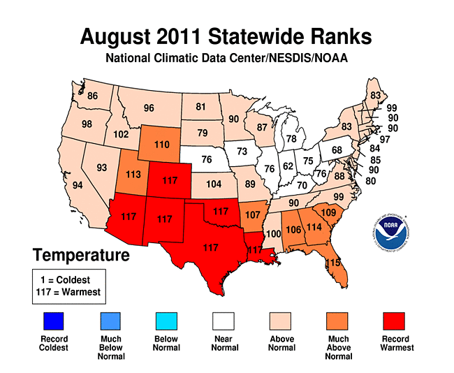
On a statewide basis, August 2011 ranked in the top ten driest Augusts for eight states (six in the South and Southeast, plus Illinois and Washington) and wettest on record for four states in the Northeast. Twelve other states ranked in the dry third of the historical record for August. But record dryness occurred for several states at several other time scales (Texas for summer [June-August]; Texas and New Mexico for March-August; Texas, New Mexico, and Louisiana for January-August; and those same three states plus Georgia for the last 12 months [September 2010-August 2011]). For Texas and New Mexico, most of the "seasons" or time scales from June-August back to September 2010-August 2011 were the driest on record, and for Louisiana and Georgia, most of the longer time scales (January-August back to September 2010-August 2011) were the driest on record. For the year-to-date in Louisiana, the last seven January-August periods have been drier than normal. Widespread dryness in the drainage basins of the Rio Grande and Texas Gulf Coast rivers has resulted in the driest water-year-to-date (October-present) for those river basins. The record dryness this year was accompanied by record heat statewide for several states in the Southwest to Southeast at various time scales (August, June-August, March-August, January-August, and September 2010-August 2011).
 |
 |
 |
 |

Texas statewide potential evapotranspiration, summer, 1900-2011.
The combination of intense dryness and high evapotranspiration due to extremely warm temperatures has resulted in a continuation of intense drought conditions across the Southern Plains. Two-thirds of the South region, 95 percent of Texas, and 85 percent of Oklahoma were rated in extreme to exceptional drought according to the August 30th USDM, continuing at record high levels based on the 11-year history of the USDM. August ended with 31 percent of New Mexico in exceptional drought after reaching a record 49 percent earlier in the summer. In the Southeast, the current drought is just the latest in a series of drought episodes during the last decade. Eighty percent of Georgia, which is at the epicenter of the Southeast drought, was afflicted by extreme to exceptional drought, which is second to the state's drought of 2000 in the USDM record.
On a more localized basis, record dryness has occurred for at least one climate division in the Southwest, Southern Plains, or Southeast at every time scale from the three-month period, July-August 2011, through the 12-month period, September 2010-August 2011, and for several climate divisions in the Gulf Coast states, Midwest, and West during August 2011. Record warm temperatures have occurred for at least one climate division during all of the last 12 time periods or "seasons" (August 2011 back through September 2010-August 2011), especially in the Southern Plains during the spring and summer:
|
|
|
The prolonged and intense drought conditions have caused a rapid intensification of the PHDI, with the August 2011 PHDI at record low values for several climate divisions in the Southwest to Lower Mississippi Valley (reliable PHDI records go back to January 1900). There were two epicenters of record low PHDI values — one from eastern New Mexico into western Texas and southwest Oklahoma, and the other from northwestern and central Louisiana into adjacent eastern Texas. The climate divisions with record low PHDI values include:
|
|
|
The PHDI reached record or near record intensity in southwestern Georgia (climate divisions 7 and 8), southwest Kansas (climate division 7), central New Mexico (climate division 6), the Texas Edwards Plateau (climate division 6), the Rio Grande and Texas Gulf Coast river basins, and, on a statewide basis, in Louisiana, New Mexico, and Texas. In all of these cases, even though the intensity of the current drought is record or near-record, the duration of earlier droughts exceeds the duration of the current drought.
 |
 |
 |
 |

Percent area of the Western U.S. in moderate to extreme drought, based on the Palmer Drought Index.
The West was generally drier than normal in August, but this did little to change the overall pattern for the water year to date (October-present) — extremely dry conditions have been persistent from Arizona and New Mexico into eastern Colorado, but abundant precipitation has fallen across the rest of the West. This is evident in both the low elevation station precipitation as well as the high elevation (SNOTEL) station precipitation, modeled soil moisture, and PHDI. An analysis of early data by the USDA indicated that reservoir levels were, on average, below normal in New Mexico, where drought was an issue, to near or above normal in the other western states. According to the USDM, 20 percent of the West was experiencing moderate to exceptional drought at the end of August, about the same as July, while the Palmer Drought Index statistic was about 18 percent, an increase of about 4 percent. When the statistics for the Arizona-New Mexico-Colorado drought area (the Southwest drought area) are aggregated, the percent area in moderate to exceptional (USDM categories) drought has fluctuated between 60 and 70 percent for the last six months. The percent area in the exceptional and extreme to exceptional categories steadily increased from March to June then leveled off with monsoon showers in July, then decreased slightly in August, holding steady at about 31 percent in extreme to exceptional drought at the end of this month.
A more detailed drought discussion, provided by the NOAA Regional Climate Centers and others, can be found below.
West — Upper Colorado River Basin — Pacific Islands
As noted by the Southeast Regional Climate Center, precipitation in August was generally below normal across the Southeast, except in areas affected by tropical cyclones. Tropical Storm Emily dropped 6-10 inches (152.4-254.0 mm) of rain across Puerto Rico on the 3rd and 4th of the month, resulting in major flooding and several landslides. Towards the end of the month, Hurricane Irene dropped as much as 22 inches (558.5 mm) of rain along the eastern slopes of the island. For the month, San Juan, Puerto Rico recorded 18.56 inches (471.4 mm) of rain, which set a new all-time monthly record. Hurricane Irene also dropped between 8-15 inches (203.2-381.0 mm) of rain across eastern sections of North Carolina and Virginia on the 27th and 28th of the month. The driest locations across the Southeast (less than 50 percent of normal) were found across most of Georgia, eastern Alabama, and the Florida Panhandle. Tallahassee, Florida recorded 2.03 inches (51.6 mm) of rain for the month, making it both the driest August as well as the driest meteorological summer in a record extending back to 1892. San Juan recorded 43.24 inches (1098.29 mm) of rain from June through August, making it the wettest summer in a record extending back to 1902.
Mean temperatures in August ranged from 1-2 degrees F (0.5-1.1 degrees C) above normal across the northern tier of the region to 3-4 degrees F (1.6-2.2 degrees C) above normal across most of the southern tier. Several locations in the Southeast experienced their warmest August on record. For the second consecutive year, the end of August marked one of the warmest meteorological summers (June-August) on record at several locations across the Southeast. Locations that experienced their warmest summer on record in 2011 included Tallahassee, Florida; Augusta, Georgia; Athens, Georgia; Columbus, Georgia; Savannah, Georgia; Charleston, South Carolina, Columbia, South Carolina, and Cape Hatteras, North Carolina.
While Hurricane Irene helped eliminate the regions of severe and extreme drought (D2 and D3) across eastern North Carolina, there were few other changes in the USDM across the Southeast in August. The continued dryness across much of Georgia contributed to several wildfires. According to the Georgia State Climate Office, more than 2,230 acres burned across the state in August, which was double the long-term average for the month.
As explained by the Southern Regional Climate Center, dry conditions continued into August for much of the Southern region. With the exception of Arkansas and eastern Oklahoma, conditions were quite drier than normal. Arkansas averaged a total of 4.12 inches of precipitation for the month, making it the twenty-eighth wettest August on record (1895-2011). Most stations in the interior portions of the state reported between 130 to 200 percent of normal. Similar conditions were observed in eastern Oklahoma and in a small part of central Texas. Elsewhere, conditions were much drier than normal with the majority of stations recording less than 50 percent of normal precipitation. The state of Texas recorded its third consecutive month of less than one inch (25.4 mm) of precipitation. The State averaged only 0.73 inch (18.54 mm), making it the fifth driest August on record (1895-2011). Louisiana averaged only 1.81 inches (45.97 mm) of precipitation for the month, which equates to the third driest August on record (1895-2011) there. Mississippi experienced its sixth driest August on record (1895-2011) with a average monthly precipitation total of just 1.80 inches (45.72 mm). It was also a very dry month for Tennessee, which recorded only an average of 1.44 inches (36.58 mm) of precipitation, or its fourth driest August on record (1895-2011). Oklahoma averaged 2.49 inches (63.25 mm) of precipitation. This equates to the forty-ninth driest August on record (1895-2011). It is worth noting that much of the state was quite drier than that statistic implies, which is somewhat biased by much wetter than normal conditions that occurred in the easternmost counties.
As was the case in both June and July, August was again a very warm month for the Southern region. The region as a whole averaged a temperature of 86.00 degrees F (30.00 degrees C). This is the warmest August on record (1895-2011) for the Southern region. The majority of stations in the region averaged between 2 to 6 degrees F (1.11 to 3.33 degrees C) above normal. The highest temperature anomalies occurred in central and northern Texas, and throughout most of Oklahoma. Stations there averaged between 6 to 10 degrees F (3.33 to 5.56 degrees C) above monthly expected values. It is therefore not surprising that both Texas and Oklahoma experienced their warmest August on record (1895-2011). It is worthy noting that both of these states are also following their warmest July on record (1895-2011). The August Texas average temperature was an astounding 88.10 degrees F (31.17 degrees C), while in Oklahoma, the state average temperature for was 87.40 degrees F (30.78 degrees C). With a statewide average temperature of 86.20 degrees F (30.11 degrees C), Louisiana also recorded its warmest August on record (1895-2011).
A third consecutive month of anomalously warm and anomalously dry conditions led to a worsening of drought conditions in the Southern region. As of August 30, 2011, approximately 54 percent of the region was experiencing exceptional drought — the highest designation of drought by the National Drought Mitigation Center. This area includes approximately eighty-one percent of Texas, sixty-nine percent of Oklahoma, and thirty-eight percent of Louisiana. Some drought improvement occurred in Arkansas, where wetter than normal conditions dominated for part of the month. According to the Texas Forestry Service, 20,155 fires have been reported in Texas since the beginning of Wildfire Season on November 15, 2010. Since then, over 3.5 million acres have been scorched and Texas held approximately 51 percent of the total acres burned in the United States alone. During the current wildfire season, 3,056 homes and structures have been lost. However, with the aid of brave men and women from Texas and literally every other state in the nation, 42,077 homes and structures were saved this year. In addition, a record-breaking 251 of 254 counties enforced a burn ban by the end of August. (Information provided by the Texas Office of State Climatology) Some areas of Texas did receive precipitation in August, but the amounts of rain were far from enough to remove the burden of the "worst one-year drought in recorded history." Farmers and ranchers were hit the hardest during August 2011 and the crop and livestock reports had the evidence to prove it. As the costliest drought in Texas history, losses were estimated to be at $5.2 billion at the end of the month. Ranchers practically liquidated their herds as the water wells went dry and supplemental feeding became too expensive. Likewise, farmers were forced to give up on particular plots and only irrigate what they believed could yield a substantial crop. Across the state, the outlook was extremely bleak.(Information provided by the Texas Office of State Climatology). Drier than normal conditions in Tennessee resulted in some moderate drought in the northwestern and central counties.
As summarized by the Midwest Regional Climate Center, August precipitation varied considerably across the Midwest. The wettest area extended from southwest Iowa to south central Missouri which received 150 to 200 percent of normal for the month. The driest stretch extended across Illinois, roughly from Hancock County to Lawrence County, which received less than 25 percent of normal for the month. A small part of southern Minnesota also received less than 25 percent of normal and all states except Ohio had pockets with less than 50 percent of normal. Summer rainfall, June to August, also varied across the region but to a lesser extent. Most locations received between 75 percent and 125 percent of normal.
August temperatures in the Midwest were near normal to slightly above normal. The warmest area was in southwest Missouri where temperatures were as much as 5 degrees F (3 degrees C) above normal. Temperatures for the summer months, June to August, averaged slightly warmer. Most of the Midwest was 1 degrees F to 4 degrees F (1 degrees C to 2 degrees C) above normal with southwest Missouri again the warmest with temperatures 4 degrees F to 6 degrees F (2 degrees C to 3 degrees C) above normal.
Crop stress became much more widespread in August with the dry conditions of the month following a hot, and in many locations dry, July. Due to the weather and following disappointing field surveys in many locations, crop yield estimates were lowered well below the 5-year averages. Yields are also expected to vary considerably from field to field and even within fields. Drought-affected areas in the Midwest expanded from less than 1 percent% on July 26th to more than 18 percent on August 30th. Severe Drought area went from 0 percent to nearly 5 percent of the Midwest in the same time period.
As noted by the Northeast Regional Climate Center, rainfall totals were above normal in most of the Northeast, even before Tropical Storm Irene's drenching at the end of the month. The region averaged 7.34 inches (186 mm), which was 189 percent of the normal amount. It was the 2nd wettest August in the Northeast in 117 years, surpassed only by August 1955. Four states (New Hampshire, New Jersey, New York, and Vermont) saw their wettest August since 1895. It was the 2nd wettest in Connecticut and Massachusetts, the 3rd wettest in Maine and the 5th wettest in Pennsylvania. State departures ranged from 353 percent in New Jersey to 93 percent in West Virginia, the only state to average below normal this month. With all the rain during August, drought concerns were limited to two small areas of moderate drought (D1) along the eastern West Virginia border.
August temperatures averaged warmer than normal for the eighth consecutive month. The Northeast's average was 69.1 degrees F (20.6 degrees C), which was 0.7 degrees F (0.4 degrees C) above normal. The summer (June-August) of 2011 also averaged above normal, in fact it was the 11th warmest summer since 1895.
As explained by the High Plains Regional Climate Center, dryness prevailed across southern Kansas, eastern Colorado, central Wyoming, eastern South Dakota, and northern North Dakota. Extreme (D3) to exceptional (D4) drought conditions persisted across much of southern Colorado and southern Kansas. While some areas of the extreme drought conditions in Colorado were downgraded, relief was not in store for southern Kansas as the area received lower than normal precipitation. Dodge City, Kansas had its 6th driest August on record and only received 0.65 inches (17 mm) of precipitation, which was 24 percent of normal (period of record 1874-2011). The driest August on record occurred in 1894 with 0.15 inches (4 mm) of precipitation. Dodge City also recorded its driest summer on record with 1.58 inches (40 mm) of precipitation. Interestingly, the year-to-date (January 1 - August 31) precipitation of 4.60 inches (117 mm) was also the lowest on record. While drought conditions occurred in the southernmost portions of the region, a large section stretching from northern Kansas up through central North Dakota experienced many storms and was wetter than normal.
Temperatures varied across the region. August 2011 temperatures were generally near normal for the majority of Nebraska and the Dakotas. However, a large area of Colorado and Kansas had temperature departures ranging from 4-8 degrees F (2.2-4.4 degrees C) above normal. By the end of the month, several locations were ranked in the top 5 warmest Augusts on record. Dodge City, Kansas broke multiple records by having its warmest and driest summer on record (period of record 1874-2011). With an average temperature of 83.5 degrees F (28.6 degrees C), Dodge City was able to break the previous record of 83.4 degrees F (28.6 degrees C) set during the Dust Bowl in 1934. Dodge City also had 50 days at or above 100 degrees F (37.8 degrees C) this summer which crushed the old record of 42 days also set in 1934. The ongoing hot and dry conditions across southern Kansas and Colorado have stressed crops and livestock. According to the National Agricultural Statistics Service livestock liquidations took place throughout the month in order to reduce stress on pastures and water supplies.
Several changes occurred to the USDM this month. Crop stress in eastern South Dakota and Nebraska led to an introduction of mainly abnormally dry conditions (D0). However, a small area of moderate drought (D1) developed in far southeastern South Dakota. By mid month, D0 was also present in the Black Hills area of South Dakota, a small portion of eastern Wyoming, and far northwestern Nebraska. Scattered showers across eastern Colorado allowed for a one-category improvement for a good portion of the extreme drought conditions (D3). Meanwhile, D3 and D4 (exceptional drought conditions) expanded in western Kansas as hot and dry conditions persisted.
As summarized by the Western Regional Climate Center, in summary, August saw continued cooler than average temperatures along the Pacific coast, and average to record breaking warmth throughout the inland West. Precipitation was low throughout the region, with only weak monsoonal rainfall bringing scattered high precipitation values to some of the Rocky Mountain areas and Southwest states. Drought conditions remained in Arizona and New Mexico.
Precipitation was generally lower than average in the West. Numerous locations in the Pacific states received no precipitation at all for the month, where little if any is typically expected. Portland, Oregon reported a monthly total of 0.17 inches (4.3 mm), 0.71 in (18 mm) below the August average of 0.88 in (22.4 mm). At 20 percent of average rainfall, this ranked as the 18th driest July in a 70-year record. Only the far northwestern tip of the Olympic Peninsula received above average rainfall. The rain forest airport at Quillayute received 3.22 in (81.7 mm) on the 22nd, an impressive amount for summer that would receive scant attention in the winter, and ended the month with 3.27 in (83.1 mm), 131 percent of average.
Monsoonal activity favored a few scattered locations in the inland mountainous West, though most were dry. This provided some relief from extreme drought conditions affecting New Mexico, Arizona, and southern Colorado. The monsoon season, mostly now ended, was lighter than usual nearly everywhere in the Southwest except in eastern Utah.
Strong thunderstorm downdrafts associated with monsoon activity caused a haboob (dust storm) 1,000 feet (305 m) to pass through the Phoenix area on August 18. This was the third such notable event to occur in Arizona this summer.
Coastal California continued to see cooler than normal temperatures throughout the month of August due to a persistent marine layer. Except for the coast, the Southwest saw higher than average temperatures throughout August, with many records being set in southeastern California, Arizona, and New Mexico. Farther north, August 2011 was the hottest on record at Denver, Colorado with an average temperature of 77 F (25 C), surpassing the 76.8 F (24.9 C) of 1937. Boise, Idaho experienced an average temperature of 78.4 F (25.8 C), the second highest average August temperature since 1940. Many daily high temperature records were set in inland Oregon, Wyoming, Idaho, and Colorado.
The Southwest experienced moderate to exceptional drought during the month of August, with only little relief provided by monsoon rains throughout the month. The severity of the drought was reduced in some parts of New Mexico and Southern Colorado by the end of the month, while drought indices increased for much of Arizona. The drought continued to affect agriculture in the Southwest. Livestock in New Mexico were sold off in large numbers as not enough feed could be grown to sustain the animals.
Upper Colorado River Basin: As reported by the Colorado Climate Center, the August 30th NIDIS (National Integrated Drought Information System) assessment for the Upper Colorado River Basin (UCRB) indicated that, for the month of August, precipitation was widespread around the UCRB and eastern Colorado. For the water-year-to-date (WYTD) (October 1, 2010 - August 27, 2011), most of the UCRB received near or above average precipitation. The Upper and Lower Green River basins received over 200 percent of their average WYTD normal precipitation in many spots. The southern portion of the UCRB was drier, seeing around 70 to 100 percent of average.
As of August 28th, about 91 percent of the USGS streamgages in the UCRB recorded normal (25th - 75th percentile) or above normal 7-day average streamflows. All of the major reservoirs' storage volumes in the UCRB decreased throughout August, with Green Mountain, Lake Granby, and Lake Dillon seeing only minor decreases. All of the major reservoirs above Lake Powell were near or above their average August levels near the end of the month. This April - July period was the 3rd wettest with regard to inflows into Lake Powell since operations at Glen Canyon Dam began in 1963. Lake Powell's volume was 88 percent of average and 74 percent of capacity by month's end.
During the last week of August, warmer than average temperatures were observed over the UCRB, and also across the Front Range and eastern plains of Colorado. The warmer temperatures contributed to higher reference evapotranspiration (refET) in drought stricken areas. In the San Luis Valley, refET was near the highest refET year (the drought of 2002), so precipitation falling there could be quickly lost to the atmosphere again. Very high refET rates were also seen in the Arkansas River basin. Poor soil moisture conditions were seen in parts of southeast and northeast Colorado and southern Wyoming, with conditions deteriorating in eastern Utah. Satellite imagery of vegetation conditions indicated very dry vegetation with little growth in the San Luis Valley and southeast Colorado. Vegetation conditions were moist for the northern portion of the UCRB, slightly dry in the Four Corners area, and slightly drier than average for northeast Colorado.
Pacific Islands: According to reports from National Weather Service offices, the Pacific ENSO Applications Climate Center (PEAC), and partners, conditions varied across the Pacific Islands.
As noted by the National Weather Service office in Honolulu, well below-normal rainfall combined with seasonally warm temperatures in August increased drought conditions in coverage and intensity over leeward areas of the Big Island and Maui County. A month ago only a small section of the south Kohala district on the Big Island contained severe drought, or D2 category conditions on the USDM map. However, continued dry conditions over the past several weeks have increased severe drought coverage to encompass most of the north Kona and south Kohala districts and the southern portion of the Kau district. Leeward Big Island areas not under D2 conditions were considered to be under D1, or moderate drought. In Maui County, severe drought returned to the leeward Haleakala slopes from Kamaole to Ulupalakua and moderate drought has spread northward to cover upcountry Maui through Makawao. Severe drought over the western third of Molokai remained in place and moderate drought returned to Lanai following a few months of improved vegetation conditions. Kauai and Oahu remained drought-free though drier-than-normal conditions may soon result in the onset of drought-related problems. USGS monthly stream flow averages for August indicated that most of the monitored streams across the state were at near normal to below normal flow levels.
Some drought impacts in Hawaii include the following:
- On Oahu, there were no drought impacts to report. The water supply in the Waimanalo reservoir has been decreasing but remains above drought level. However, the State of Hawaii Department of Agriculture is maintaining a voluntary 10 percent cutback in irrigation water use as a precaution.
- On Molokai, the State of Hawaii Department of Agriculture has kept in place the mandatory 30 percent cutback in irrigation water consumption for the Kualapuu reservoir system.
- On Lanai, pastures and general vegetation conditions have declined over the past month.
- On Maui, pastures and general vegetation conditions have declined along the leeward slopes of Haleakala and were beginning to impact ranching operations. Water supply levels for upcountry Maui have been declining in recent weeks prompting the Maui County Department of Water Supply to reiterate their call for a 5 percent reduction in water use. The request for a 10 percent reduction in water use by central and south Maui residents also remained in effect.
- On the Big Island, drought impacts over the leeward areas of the island have increased over the past month. Pastures and general vegetation from Kawaihae to north Kona were in poor condition. Grasses that sprouted from the April rains were dying. Ponoholo Ranch in north Kohala reported 30 to 40 percent forage conditions. Pastures in south Kau from Kapapala to South Point were deteriorating quickly with ranchers indicating 30 to 60 percent forage. Many ranchers have already destocked cattle and water hauling operations have been ongoing for several months.


On other Pacific Islands, drought conditions at near-equatorial islands such as Kapingamarangi (near latitude 1 N, longitude 156 E) effectively ended when the La Niña pattern across the equatorial Pacific transitioned to ENSO-neutral earlier this year and tropical rains returned in earnest. For example, Kapingamarangi Atoll had 7.14 inches of rain from September 2010 through February 2011, which is 15 percent of normal for that period and equates to a monthly average of 1.19 inches. Once rains returned, the period from March to August 2011 had 80.73 inches which is 122 percent of normal for that period or a monthly average of 13.46 inches. As seen in the table below and in SPI values calculated by the Honolulu NWS office, rainfall across the western Pacific has been highly variable from month to month. August rainfall was mostly near to above normal. Long-term (September 2010-August 2011) deficits remained at a couple of the islands. It should be noted that even though the islands had deficits, they were relatively insignificant due to the large monthly rainfall amounts these islands normally experience.
| Station Name | Sept. 2010 | Oct. 2010 | Nov. 2010 | Dec. 2010 | Jan. 2011 | Feb. 2011 | Mar. 2011 | Apr. 2011 | May 2011 | Jun 2011 | Jul 2011 | Aug 2011 | Sep. 2010-Aug. 2011 |
| Chuuk | 114% | 113% | 66% | 85% | 76% | 137% | 156% | 109% | 66% | 218% | 124% | 147% | 116% |
| Guam IAP | 90% | 112% | 53% | 76% | 205% | 166% | 138% | 142% | 95% | 96% | 195% | 109% | 117% |
| Kapingamarangi | 12% | 26% | 25% | 9% | 22% | 2% | 61% | 74% | 69% | 247% | 199% | 214% | 77% |
| Koror | 103% | 89% | 94% | 75% | 163% | 145% | 170% | 130% | 180% | 129% | 166% | 145% | 132% |
| Kosrae | 40% | 85% | 74% | 76% | 82% | 67% | 51% | 74% | 151% | 114% | 76% | 105% | 83% |
| Kwajalein | 71% | 162% | 158% | 37% | 119% | 316% | 277% | 49% | 91% | 121% | 100% | 135% | 122% |
| Majuro | 166% | 96% | 142% | 95% | 100% | 190% | 188% | 28% | 109% | 97% | 118% | 106% | 116% |
| Pago Pago | 132% | 153% | 82% | 92% | 183% | 110% | 52% | 36% | 35% | 132% | 40% | 60% | 95% |
| Pohnpei | 100% | 75% | 97% | 75% | 98% | 125% | 148% | 47% | 95% | 128% | 85% | 120% | 97% |
| Saipan | 67% | 40% | 82% | 43% | 182% | 124% | 164% | 209% | 154% | 174% | 110% | 108% | 99% |
| Yap | 74% | 141% | 98% | 69% | 164% | 123% | 171% | 129% | 169% | 113% | 157% | 133% | 126% |

[top]
State/Regional/National Moisture Status
A detailed review of drought and moisture conditions is available for all contiguous U.S. states, the nine standard regions, and the nation (contiguous U.S.):
| northeast u. s. | east north central u. s. | central u. s. |
| southeast u. s. | west north central u. s. | south u. s. |
| southwest u. s. | northwest u. s. | west u. s. |
| Contiguous United States |
[top]
Pre-Instrumental Perspective
Extraordinarily severe drought conditions have gripped Texas, Oklahoma, and portions of adjoining states since October 2010. In Texas, statewide precipitation for the past 12 months was only 51 percent of normal, the driest September-August period in the 1895-2011 record. The extreme values in key drought indicators reflect both the precipitation anomaly and record hot temperatures across Texas this summer. The U.S. Drought Monitor for late August showed that 81 percent of Texas was in category D4, "exceptional drought". The monthly Palmer Drought Severity Index (PDSI) for Texas for June-August 2011, averaged across the three months and all 10 Texas climate divisions*, was -5.37, which is well below the threshold for "extreme drought" (-4), according to the PDSI scale.
 |
 |

Texas summer (June-August) statewide PDSI, paleo reconstruction and instrumental, 1550-2011.
The graph to the right shows the observed summer (June-August) PDSI, 1895-2011, averaged across the 10 Texas climate divisions* (annual values in light blue, 5-year weighted average in dark blue). The value for 2011 is the lowest on record (brown arrow). The most persistent statewide drought was in the 1950s (yellow arrow), when summer PDSI was below -2 for six years in a row (1951-1956), bottoming out in 1956 with a value of -4.88, the second-lowest on record after 2011.
The graph above right also shows a 429-year tree-ring reconstruction (1550-1978) of Texas summer (June-August) PDSI. Annual values are in light red, with a 5-year weighted average in dark red. This time-series was composited from the 13 gridpoint reconstructions within the state of Texas from the gridded network of reconstructions developed by Cook et al. (1999, 2004) covering most of North America. The composite Texas reconstruction is based on tree-ring data from over 100 sites in Texas and surrounding states. The correlation between the reconstructed statewide PDSI and the statewide instrumental PDSI record over their common period (1896-1978) is 0.826, indicating a very high degree of shared variance.
The tree-ring record can put the droughts of the last century across Texas, including 2011, into a much longer perspective. The frequency of severe one-year statewide droughts appears not to have significantly changed between the "paleo" period (1550-1894) and the instrumental period (after 1895). Both the instrumental and reconstructed PDSI records indicate that "severe" or "extreme" statewide summer drought (PDSI below -3) occurred in about 1 in 15 years. "Extreme" statewide summer droughts (PDSI below -4) such as 2011 and 1956 are seen in about 1 in 40 years in both the instrumental and reconstructed records.
So how does the 2011 summer PDSI (-5.37) compare to the worst one-year paleo-droughts? We first need to consider that the tree rings are imperfect recorders of past drought, and so the reconstructed values have confidence intervals (or "error bands") associated with them. When this error band is taken into account, there is only one value in the paleo record, 1789 (-5.14), that can be said to be equivalent to the 2011 observed value. Thus, 2011 appears to be unusual even in the context of the multi-century tree-ring record.
The severe and sustained 1950s drought likewise stands out in the context of the multicentury tree-ring record. From 1951 to 1956, the average instrumental summer PDSI was -3.38 (the average tree-ring reconstructed summer PDSI was -3.11). There is one close analog in the paleo-record, a six-year drought 1859-1864 (orange arrow), for which the average reconstructed summer PDSI was -3.10. Also of note in the paleo-record is the period from 1785 to 1790 (red arrow), in which a three-year drought (average reconstructed PDSI: -2.61) was followed by one wet year and then by two consecutive years with reconstructed PDSI below -4, one of which was 1789 as described above.
The current drought in Texas has been unprecedented relative to the century-long observed record in a number of ways: the record-low precipitation, the extreme summer heat, and the enormous wildfires. The tree-ring record of PDSI confirms that, in a much longer context, the 2010-2011 Texas drought is an extraordinary event.
* Note About the Observed PDSI Data:
The Texas observed PDSI data used in this analysis were generated from the area-weighted average of the individual PDSI values for the ten Texas climate divisions. The standard NCDC statewide Texas observed PDSI product is calculated and standardized on a statewide basis, rather than being averaged from the divisional data, so those values are different from the ones reported here. The area-averaged divisional data were used in order to match the properties of the Texas tree-ring PDSI record, which likewise is the average of multiple time-series representing the different parts of the state.
Resources:
- Divisional and statewide climate data, including PDSI for Texas, can be obtained from NCDC: Climate Division: Temperature-Precipitation-Drought Data
- The summer PDSI reconstructions are available online from the NOAA Paleoclimatology Branch: NOAA/NESDIS North American Drought Variability
References:
- Cook, E. R., D. M. Meko, D. W. Stahle, and M. K. Cleaveland, 1999. "Drought reconstructions for the continental United States." Journal of Climate, 12:1145-1162.
- Cook, E. R., C. A. Woodhouse, C. M. Eakin, D. M. Meko, and D. W. Stahle, 2004. "Long-Term Aridity Changes in the Western United States." Science, 306(5698):1015-1018.
[top]
Drought Indicators
- Palmer Drought Indices
- Standardized Precipitation Index
- long-term (36 to 60 month) percent of normal precipitation maps
- airport station percent of normal precipitation maps
- statewide precipitation rank maps
- Cooperative station percent of normal precipitation maps
- percent of average maps for the SNOTEL stations in the western mountains provided by the Western Regional Climate Center
- hydrologic year precipitation
- snow water equivalent of snowpack
- satellite-based observations of vegetative health
- National Weather Service model calculations of soil moisture, runoff, and evaporation
- National Weather Service model calculations of soil moisture using the Leaky Bucket Model
- Midwest Regional Climate Center model calculations of soil moisture
- topsoil moisture conditions observed by the USDA and mapped by the Climate Prediction Center
- pasture and range land conditions observed by the USDA and mapped by the Climate Prediction Center
- streamflow maps maintained by the USGS
[top]
Contacts & Questions