|
Contents Of This Report: |

|
National Drought Overview
|
|
[top]
Detailed Drought Discussion
Overview
September 2010 was wetter (38th wettest) and warmer (14th warmest) than normal when weather conditions are averaged across the country. But considerable variability occurred throughout the month (weeks 1, 2, 3, 4, 5) and on a regional basis. Spotty to widespread beneficial rain fell across parts of the drought (D1-D2) and abnormally dry (D0) areas of Arizona and the southern and northern Plains. The other D0-D4 areas in the West and in Hawaii and Alaska saw little beneficial rain. Unusually warm temperatures increased evaporation which, combined with very dry conditions, expanded areas of D0 (abnormally dry) to D3 (extreme drought) from the Lower Mississippi Valley to the Ohio Valley. These weather conditions severely impacted agriculture, expanding abnormally dry and drought conditions also in the Southeast and up the Eastern Seaboard during most of the month (weeks 1, 2, 3, 4). Heavy rains during the last 2 days of September (29th, 30th) and beginning of October brought significant improvement to the East from the Carolinas to New England (end of September USDM compared to beginning of October USDM).

The U.S. Drought Monitor drought map valid September 28, 2010.
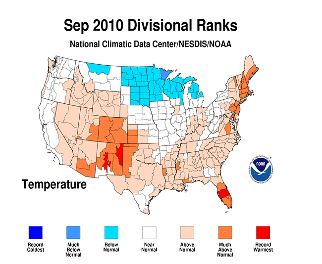
The  weather pattern for September consisted mostly of the Bermuda High pressure system (also known as the North Atlantic High) dominating the southern states with an active jet stream across the northern states. The Bermuda High brought persistent hot temperatures and dry weather to much of the region, deflecting most of the tropical systems out into the Atlantic or guiding them across the Caribbean and Gulf of Mexico along its southern periphery. However, moisture from the remnants of some of the tropical storms and hurricanes penetrated into the southern U.S., bringing locally heavy rains. These included the remnants of Tropical Storm Hermine, which moved across the Southern Plains early in the month, and Hurricane Karl, which moistened Texas and areas further north in mid-September. Increased evaporation from unusually hot temperatures worsened drought conditions for those areas missed by the tropical moisture. By the end of the month, Louisiana had the second driest September on record and Mississippi third driest, with dry conditions spreading into the Ohio Valley. Ten states, in the Southwest, Southeast, and Northeast, had the top ten warmest September on record.
Meanwhile, at least half a dozen strong low pressure systems and associated cold fronts moved across the northern states as they formed and were caught up in the jet stream flow. As a result of this persistent frontal activity, below-normal temperatures and heavy rains dominated the Northern Plains and western Great Lakes. Moisture from the remnants of Hurricane Karl became entrained in the circulation, bringing flooding rains to parts of southwest Wisconsin, southern Minnesota, and southeast South Dakota and contributing to Minnesota's wettest September in the 1895-2010 record.
A change in the upper-level circulation occurred during the last week of September. A dry high pressure ridge developed in the West as an upper-level trough built over the eastern U.S. and a strong upper low and associated cold front moved slowly into the Southeast. This combination brought cooler temperatures and locally heavy rains to parts of the Southeast and mid-Atlantic states. Moisture from the remains of Tropical Storm Nicole affected Florida in late September and became entrained in this upper-level system at the end of September and beginning of October, bringing torrential rains which ended the drought in parts of the East.
By the end of September (pre-Nicole, September 28), 13 percent of the contiguous U.S. was affected by moderate to exceptional (D1-D4) drought. Post-Nicole (October 5), that percentage dropped to about 12 percent. The pre-Nicole core drought areas in the U.S. included:
- much of Hawaii, where moderate (D1) to exceptional (D4) drought was entrenched;
- the Lower Mississippi Valley, where moderate (D1) to extreme (D3) drought expanded;
- the western Great Lakes, where moderate (D1) to severe (D2) drought conditions lingered;
- the Ohio Valley, where moderate (D1) to severe (D2) drought expanded;
- the Southeast, which experienced improving conditions in some areas but deteriorating conditions in others (September 28 and October 5 conditions compared to August 31), with moderate (D1) to extreme (D3) drought extending from Alabama to Florida; and
- the Northeast , where moderate (D1) to extreme (D3) drought lingered (moderate to severe drought post-Nicole).
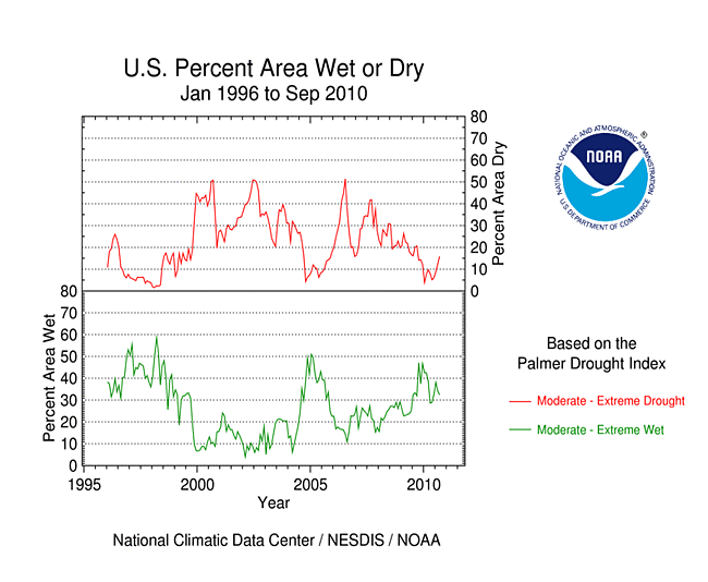
Palmer Drought Index
 |
 |
The Palmer drought indices measure the balance between moisture demand (evapotranspiration driven by temperature) and moisture supply (precipitation). The Palmer Z Index depicts moisture conditions for the current month, while the Palmer Hydrological Drought Index (PHDI) and Palmer Drought Severity Index (PDSI) depict the current month's cumulative moisture conditions integrated over the last several months. As seen on the Palmer Z Index map, low precipitation and unusually warm temperatures resulted in very dry conditions for September 2010 over the much of the Gulf coastal states and from the Lower Mississippi Valley to Ohio Valley states. But, prior to beneficial rains at the end of the month, the heat and dryness had actually afflicted most of the country from the Mississippi River to the East Coast, as seen on the Z Index map based on data through September 26. Heavy rains from a cold front, an upper-level low, and the remains of Tropical Storm Nicole very quickly changed the drought landscape from the mid-Atlantic to the Northeast in the waning days of the month (Palmer Z Index map based on data through September 26, 27, 28, 29, 30). Conditions were also dry for much of the southern and central portions of the West. Wet conditions are evident on the Z Index map along the path of the storm track in the northern states and along the path taken by the remains of tropical systems in Texas to Missouri and the coastal Carolinas and Virginia. Compared with the August 2010 PHDI map, the September 2010 PHDI map indicates that drought conditions worsened over the Southeast and that wet conditions were entrenched over the northern Plains to Upper Mississippi Valley. The September 2010 PHDI map also reflects the long-term nature of the drought conditions. The Z Index and PHDI maps in combination show that the dryness in the Southeast to mid-Mississippi Valley is both a short-term and long-term phenomenon, and that the dryness in the Ohio Valley and southern and central portions of the West is a short-term phenomenon.
Standardized Precipitation Index
 |
 |
 |
The Standardized Precipitation Index (SPI) measures moisture supply. The six SPI maps here show the spatial extent of anomalously wet and dry areas at time scales ranging from one month to 24 months. Dryness is evident across the Lower Mississippi Valley, Southeast, and parts of the Ohio Valley at the 1-month to 9-month time scales, and parts of the Northeast and mid-Atlantic at 1 to 6 months, but wetness dominates at longer (12- and 24-month) time scales. If not for the torrential rains during the last few days of September, the entire eastern seaboard would have shown up as dry on the 1- to 6-month maps. Dryness in the West is a short-term phenomenon (1 to 3 months for the central West, and 1 to 6 months for parts of the Southwest). The central High Plains have been dry at the 1-, 2-, and 3-month time scales, but wet at the longer time scales. With the exception of Idaho, the Pacific Northwest to Montana is depicted as wet at the 1- to 12-month time scales. The northern Plains to adjoining Midwest and mid-Mississippi Valley are depicted as persistently wet at most time scales.
 |
 |
 |
Agricultural Indices
 |
 |
Abnormal dryness and drought were evident in several indicators. September is still in the dry season across the coastal West, so it is normal to have few days with rain in this area. But the dearth of days with rain this month spread from coastal California across the Great Basin and into the central and southern Rockies and central High Plains. There were also only a handful of rain days across much of the Southeast and into the Ohio Valley. This resulted in long runs of consecutive dry days in some areas. The September heat magnified the effects of the dry weather, drying soils and stressing vegetation. Soil moisture, as observed (percent of topsoil dry and very dry, and comparison to median) and monitored by several models (NOAA Climate Prediction Center anomalies and percentiles, Leaky Bucket, NLDAS [North American Land Data Assimilation System] top soil layer and total soil layer), was drier than average across much of the country from the Gulf coast to Ohio Valley, parts of the Northeast and West, much of Hawaii, and parts of Alaska. According to September 26th (pre-Nicole) U.S. Department of Agriculture (USDA) reports, 80 percent or more of the topsoil was rated short or very short (dry or very dry) in Virginia (90 percent); Alabama (89 percent); Kentucky (88 percent); Connecticut, Maryland, and West Virginia (each 87 percent); Indiana (86 percent); Mississippi (82 percent); and Ohio (81 percent).

Vegetation Drought Response Index (VegDRI), September 26, 2010.
For most of September, hot temperatures and dry weather dominated much of the country east of the Mississippi. This resulted in building heat and drought stress in some crops. These impacts are reflected in the weekly Palmer Crop Moisture Index (CMI), which was developed to assess moisture conditions as they specifically relate to crops, and in other indicators (CMI for weeks 1, 2, 3, 4). A shift in the weather pattern at the end of the month brought cooler temperatures and heavy rain to many areas, but crops continued to be stressed in those areas, from the Gulf coast to the Ohio Valley, which did not receive the beneficial rains. Satellite monitoring of vegetation health (Vegetation Drought Response Index [VegDRI], Vegetation Health Index [VHI]), and the U.S. Geological Survey (USGS) agro-hydrologic model (Soil Water Index [SWI], Water Requirement Satisfaction Index [WRSI]), indicated stress on vegetation across much of the country, with the greatest stress ("wilting" category on the SWI) from the Lower Mississippi Valley to Ohio River Valley and across much of the West. The WRSI indicated potential crop failure in the mid-Atlantic as well. This was evident in the September 26 VegDRI and September 30 VHI indicators, although the post-Nicole October 3 VegDRI reflected the effect of the beneficial — although torrential — rains. The VHI also observed stress on vegetation in western Alaska and the central High Plains. Drought impacts were showing up on the pastures and rangeland from the Lower Mississippi Valley to Ohio Valley and mid-Atlantic coast, with half or more of the pastures and rangeland rated in poor or very poor condition in North Carolina (53 percent), Alabama (56 percent), Pennsylvania (58 percent), Indiana (60 percent), Kentucky (65 percent), Mississippi (67 percent), West Virginia (67 percent), and Virginia (70 percent). This was a significant departure from the long-term average and a major deterioration compared to 4 weeks ago. According to September 27th USDA reports, a third or more of the corn and/or soybeans were rated in poor or very poor condition in West Virginia (57 and 75 percent, respectively), North Carolina (34 and 35 percent), Delaware (48 and 29 percent), Maryland (39 and 30 percent), Alabama (19 and 34 percent), Virginia (48 percent soybeans), Kentucky (35 percent soybeans), and Georgia (33 percent soybeans). In addition, 85 percent of the apple crop in West Virginia, and in Virginia, 74 percent of the peanut crop and 53 percent of the cotton crop, were rated poor or very poor.
Hydrological Indices
More well monitoring stations (real-time network, climate response network, total active network) in the drought-stressed areas showed low groundwater this month compared to a month ago, although considerable improvement occurred where the heavy end-of-month rains fell. Streamflow (observed and modeled) was below average for the month from the Gulf coast to Ohio Valley and across parts of the Northeast and most of Hawaii, although pre-Nicole a larger area of the East Coast had below-average streamflow.
Regional Discussion
The precipitation pattern in Alaska for September 2010 was below normal at most stations, and a new D0 (abnormally dry) area was added to the southern coastal area around Anchorage. Precipitation surpluses for the last 6 months existed at several interior stations, but otherwise conditions were mostly drier than normal at the year-to-date and 3-, 12-, 24-, and 36-month time scales. While the streamflow pattern was near normal, modeled soil moisture deficits existed along the southern and northwest coastal areas and interior locations.
Below-normal precipitation fell along the southern and eastern coasts and in the interior of Puerto Rico during September. A similar pattern is evident in precipitaton anomaly maps at 60 days, but the dry areas become normal or wet at 90 and 180 days. Streamflow for Puerto Rico was near normal and the island remained drought free on the September 28th USDM map.
Rainfall was below normal at most stations across the Hawaiian Islands during September. Long-term deficits (year-to-date and last 3, 6, 12, 24, 36 months) continued to mount. The percent area of the state classified in moderate (D1) to exceptional (D4) drought at the end of September expanded to about 74 percent, as conditions deteriorated on the island of Kauai. Virtually the entire state was experiencing abnormally dry to exceptional drought conditions. Rancher reports from the island of Kauai indicate continuing degradation of pasture conditions. Some areas in the southeast portion of the island cannot support cattle. Many reports indicate pastures as being in the worst condition in many years. Seventy percent of the Big Island's national parks were "profoundly dry". The Molokai Irrigation System water level continued to decline. Phase III mandatory conservation measures continued in effect in Maui and Honolulu counties, with measures that included a mandatory 30 percent conservation in usage from all non homestead users. Livestock and pasture conditions on leeward and lower elevation areas continued to be poor. September streamflow levels were below normal across most of the islands.
 |
 |
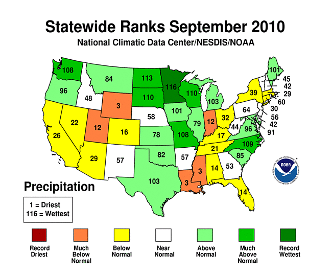
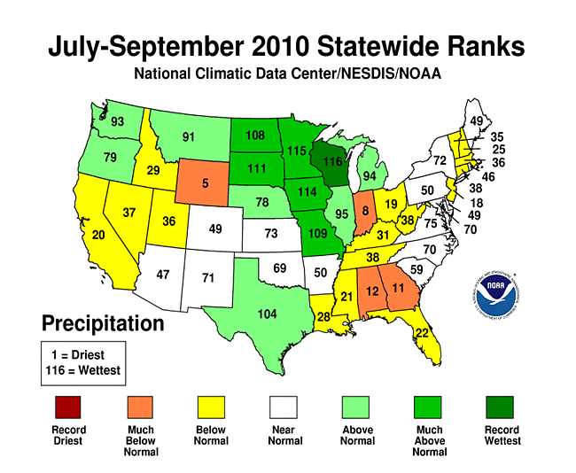
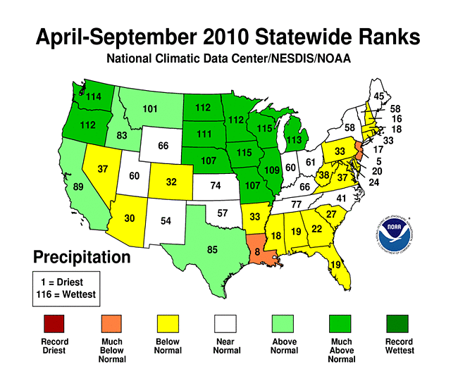
On a statewide basis, September 2010 was drier than normal for many states in the West and in the Gulf coast to the Ohio Valley. Wyoming had their driest September in the 116-year record. Louisiana had their second driest September, Mississippi third driest, Florida ninth driest, Alabama eleventh driest, and Indiana twelfth driest. The last 3 months (July-September) were drier than normal for several states in the West, Southeast, Ohio Valley, and New England, with Wyoming ranking fifth driest, Indiana eighth driest, Georgia eleventh driest, and Alabama twelfth driest. Several states in the South and East, and a few in the Southwest, were drier than normal for the last 6 months (April-September), with New Jersey ranking fifth driest and Louisiana eighth driest. Record to near-record heat occurred in the East and South during July-September with record heat widespread during April-September in the South, East, and Ohio Valley.

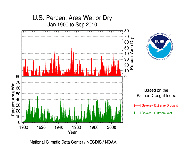
Percent area of the Western U.S. in moderate to extreme drought, January 1900-September 2010, based on the Palmer Drought Index.
September 2010 was drier than normal across much of the western United States. But more important for the West is precipitation that falls throughout the water year, defined as October through the following September. The precipitation pattern for the water year that just ended (October 2009-September 2010) was mixed at the low elevation stations and high elevation (SNOTEL network) stations. An analysis by the USDA indicated that reservoir levels were generally below average from parts of the Pacific Northwest to the interior basins. According to the USDM, 8 percent of the West was experiencing moderate to severe drought at the end of September, up 2 percent compared to August, while the Palmer Drought Index statistic hovered around 11 percent.
A more detailed drought discussion, provided by the NOAA Regional Climate Centers and others, can be found below.
As noted by the Southeast Regional Climate Center, it was truly "feast or famine" across the Southeast in September with respect to precipitation. For the first three weeks of the month, precipitation across a large portion of the region was less than 50 percent of normal and many locations were on track to set monthly record low precipitation totals. However, a combination of meteorological features across the southern U.S. and in the Caribbean produced a major precipitation event during the last week of September that affected South Florida, northeastern South Carolina, and the eastern half of North Carolina and Virginia. From the 26th to the 30th of the month, 262 record daily maximum precipitation totals were tied or broken in these regions. The precipitation was generated and sustained by a persistent feed of deep tropical moisture associated with a quasi-stationary upper-level low. Additionally, the remnants of Tropical Storm Nicole moved along a stalled frontal boundary later in the event. Over a six-day period, more than 8 inches (203.2 mm) of rain fell over eastern North Carolina and across the Virginia Tidewater region, with a swath of over 15 inches (381 mm) recorded in the North Carolina coastal plain. Wilmington, NC recorded 22.54 inches (572.5 mm) from the event, which set an all-time record for three-, four-, and five-day rainfall totals in a record extending back to 1871. The ensuing flooding resulted in a federal disaster declaration for New Hanover County. In addition, numerous thunderstorms occurred throughout northern and central Georgia beneath the core of the upper-level low. Monthly precipitation was 150 percent of normal in this region. In contrast, monthly precipitation totals remained less than 50 percent of normal across much of western North Carolina, central South Carolina, western Georgia, and central Florida. The driest parts of the Southeast (less than 25 percent of normal) were found across nearly all of Alabama, the Florida Panhandle, and parts of western and northeastern Florida. Remarkably, many COOP stations across Alabama failed to record any precipitation during the month. September precipitation was near normal across Puerto Rico.
Mean temperatures were above normal across the Southeast in September. The greatest departures occurred in a corridor from central Alabama to northern Virginia [4-6 degrees F (2.2-3.3 degrees C)] while Florida, Puerto Rico, and numerous coastal locations were 1-2 degrees F (0.5-1.1 degrees C) above normal for the month. At least 10 locations experienced their warmest September on record, including Raleigh-Durham, North Carolina, Columbus, Georgia, Tampa, Florida, and West Palm Beach, Florida. Other locations experienced near-record warmth for the month, including Atlanta, Georgia, Tallahassee, Florida, and Washington D.C. Across the region, 779 record daily maximum temperatures were tied or broken in September. The station on the University of South Carolina campus in Columbia recorded a high of 101 degrees F (38.3 degrees C) on the 20th of the month, making it the latest date in a calendar year that the temperature reached the century mark there in a record extending back to 1954. Raleigh-Durham International Airport in North Carolina recorded 16 days of 90 degree F (32.2 degrees C) temperatures or greater during the month, breaking the previous record of 15 days set back in September 1941. For the year, Raleigh-Durham has recorded 91 days of 90 degree temperatures or greater, which breaks the previous record of 83 days set back in 2007. The pattern of summer-like warmth across the region during most the month was the result of a persistent mid and upper level ridge that remained anchored over the eastern U.S. Moreover, for most of the month the region was dominated by a dry, continental air mass. Coupled with longer nights, this promoted strong radiational cooling and resulted in daily minimum temperatures that were near normal across most of the region (except for southern Florida). This was a significant change from the previous four months which saw an extraordinary number of record high minimum temperatures across the Southeast.
The warm temperatures and lack of rainfall across the Southeast in September resulted in an expansion of drought conditions across the region. By the third week of the month, over 85 percent of the region displayed D0 or greater conditions, up from 40 percent at the beginning of the month. Central portions of the Carolinas, which began the month drought-free, experienced moderate drought (D1) conditions by the end of September. The most notable change in the Drought Monitor occurred in eastern Alabama, where a small area observed extreme drought (D3) conditions. The warm, dry weather throughout much of the month continued to place stress on crops, particularly cotton, soybean, and peanuts. In Georgia, the peanut crop in particular was severely impacted as persistent warmth and dry soils forced an early season harvest with largely under-filled pods. In contrast, the pumpkin crop was plentiful across much of the region, particularly for farmers who planted early enough in the season to take advantage of the dry weather.
According to media reports, drought ravaged the corn crop in parts of Virginia. Farmers in Pulaski County expected corn yields to be cut in half, with some chopping the corn stalks for cattle feed. The Roanoke Times (9/19) noted that, "in 40 years of farming, this is the worst corn crop Lewis Pratt, 61, has ever seen."
As explained by the Southern Regional Climate Center, as was the case in August, September precipitation totals varied significantly throughout the Southern region. Only small pockets of the region experienced normal precipitation for the month; conditions were either very wet or very dry. In Mississippi, it was the third driest September on record (1895-2010). The state had a monthly total of only 0.79 inches (20.07 mm) of rainfall. Precipitation totals throughout much of the southern half of the state remained below 25 percent of the monthly normal. Conditions were also very dry in Louisiana. The Bayou state had a precipitation total of 1.36 inches (34.54 mm), which makes it the second driest September on record (1895-2010). Most stations in Louisiana reported less than half of the monthly normal. In Tennessee, conditions were dry through most of the state, except for in the north east, where some stations reported more than 150 percent of expected values. Elsewhere in the state, however, conditions were quite dry. In the western areas of Tennessee, most stations reported less than 25 percent of normal values, while in the central counties, precipitation totals ranged from 5 to 50 percent of normal. This was also the case in western Oklahoma, western Texas and the southern half of Arkansas. Areas that received an abundance of September precipitation included much of southern and central Texas and north western Arkansas. In the case of the former, a bulk of the precipitation was the direct result of tropical activity. Many stations through southern and central Texas reported precipitation totals for the month that ranged from 4 to over 15 inches (101.60 to over 381.00 mm). Tropical Storm Hermine, for example, which made landfall near Rio Grande, Texas on September 6, 2010, was responsible for dumping 15.62 inches (396.75 mm) of rainfall in Georgetown, Texas (just north of Austin). Hurricane Karl, which did not pass through Texas, did push some of its rain bands through the state. Areas in southern Texas received in excess of 10 inches (254.00 mm) from the storm, which led to widespread flooding. For the Lone Star State, it was the 18th wettest September on record (1895-2010), with a state-wide precipitation total of 4.43 inches (112.52 mm). In the case of northwestern Arkansas, heavy precipitation led to monthly totals that ranged from 150 to 300 percent of normal. Station examples of high monthly precipitation totals in northwestern Arkansas include: Lead Hill, which reported 13.79 inches (350.27 mm); Compton, which reported 11.30 inches (287.02 mm); and Omaha, Arkansas, which reported 12.98 inches (329.69 mm) for the month. In fact, almost all stations in the Northwest climate division reported over 5 inches (127 mm) of precipitation for the month.
Drought conditions in the Southern region changed dramatically during September. Dry conditions led to the introduction of moderate drought throughout much of Mississippi. This change is due in part to the fact that the state experienced its third driest September on record (1895-2010). Drought conditions also deteriorated in southwestern Louisiana, which was drought-free in August, but had moderate drought by the end of September. Similarly, dry conditions in Arkansas led to a one-category deterioration. Counties along the eastern and southern border of the state were classified as being in severe drought. Wet conditions in southern Texas, northwestern Arkansas and south central Oklahoma led to a one-category improvement from moderate drought to being drought-free. In total, as of September 28, 2010, 20 percent of the Southern region was experiencing moderate drought or worse, with 6.8 experiencing severe drought or worse. Only 0.8 percent of the Southern region had extreme drought which was confined to several Parishes in northern Louisiana.
As summarized by the Northeast Regional Climate Center, precipitation totals averaged below normal for the third month in a row. The Northeast average rainfall total for September 2010 was 3.41 inches (87 mm) and this was 86 percent of normal. Only two states, Maine (135 percent) and Maryland (125 percent), had totals that were above normal. Departures among the remaining states ranged from 53 percent of normal in Massachusetts to 79 percent of normal in New York. This month also marked the ninth consecutive month with above normal temperatures for the region; in addition, it was the 7th consecutive month that all the states in the region averaged above normal.
Three months of below normal rainfall have led to drought conditions, ranging from abnormally dry to extreme, in portions of the Northeast. According to the USDM issued September 28, 2010, the eastern panhandle of West Virginia and the western panhandle of Maryland were in extreme or severe drought, while most of New Jersey was experiencing severe or moderate drought conditions. Northern Connecticut, western Massachusetts and southern Vermont were also under moderate drought conditions. The Pennsylvania Department of Environmental Protection put 24 counties under a drought warning and the rest of the state under a drought watch as abnormally dry to severe conditions lowered ground and surface water levels. In mid-September, Maryland's Department of the Environment issued a drought warning for the western panhandle and a drought watch for the eastern shore and the Washington, DC suburbs. Drought-related reports from around the region included reduced crop yields, smaller fruit size and early drop, local water restrictions and increased fire risk. While dry and sunny conditions are generally good for tourism, quite a few boat launch ramps were closed due to reduced water levels in lakes and reservoirs.
A low-pressure system that formed over the Carolinas funneled tropical moisture to eastern U.S. on the 30th, dumping 3 to 6 inches (76 to 152 mm) of rain over central portions of the Northeast. A few locations in Maryland and southeastern Pennsylvania reported storm totals greater than 10 inches (254 mm). These totals relieved the dry conditions in the region. However, the heavy, steady rain also disrupted travel, sent rivers and streams over their banks and flooded low-lying neighborhoods. New daily rainfall records were set from West Virginia to New York, including Baltimore, Maryland (6.02 inches, 153 mm), Allentown, Pennsylvania (5.73 inches, 146 mm), Washington, DC (4.66 inches, 118 mm), Binghamton, New York (4.24 inches, mm), and Williamsport, Pennsylvania (3.91 inches, mm). Binghamton's total was an all-time daily record, topping the 4.05 inches (103 mm) that fell on June 27, 2006. Baltimore's total was the 2nd all-time highest daily amount; the wettest day was August 24, 1933 with 7.62 inches (194 mm).
As noted by the Western Regional Climate Center, rainfall was well below normal throughout the region except for the Pacific Northwest, Montana and isolated pockets of the interior Southwest. This was the third wettest September at Seattle dating back to 1948 and second wettest in Olympia. The month was very dry across the central Intermountain West. It was the first September in Lander, Wyoming, to receive no precipitation dating back to 1948 and Cheyenne was tied for the driest September (.01 inch) dating back to 1915. As a study in contrasts, this was the driest September at Pueblo, Colorado, in 54 years yet only 125 miles southeast in Clayton, New Mexico, it was third wettest September dating back 50 years.
Temperatures were mostly above normal throughout the West except for portions of coastal California, the Pacific Northwest and northern and eastern Montana. At Los Angeles Airport it was the coolest September since 1986. At San Diego-Lindbergh Field only 12 days out of the past 152 (from May-Sep) were above the 30-year normal and half of those occurred on the final 6 days of September. It was the 4th coolest May-September at San Diego in the past 80 years. The cool summer ended with the warmest reading ever at the Los Angeles Civic Center.
As explained by the High Plains Regional Climate Center, September 2010 was cool and wet in the northern portion of the High Plains region and the southern and western portions of the region were warm and dry. Overall, the wet conditions slowed the harvest of row crops; however areas planting winter wheat welcomed the rain. Above normal precipitation was mainly confined to the northern and eastern parts of the High Plains region this month. Much of North Dakota, northern and eastern South Dakota, southeastern Nebraska, and eastern Kansas received at least 150 percent of normal precipitation. The southeastern corner of South Dakota has been extremely wet this year and this month's wet spot was Brookings 2 NE, South Dakota. Brookings 2 NE received 8.43 inches (214 mm) of precipitation, or 340 percent of normal precipitation, which broke the old September record of 7.67 inches (195 mm) received in 1986 (period of record 1893-2010). The total precipitation received at Brookings 2 NE this year now totals 36.80 inches (935 mm) which sets a new record for the entire year! The previous record was in 2005 with 33.12 inches (841 mm) of precipitation.
Other areas of the region received little to no precipitation this month. The majority of Wyoming, northern and central Colorado, southwestern Kansas, and the panhandle of Nebraska all received precipitation which was only 50 percent of normal or less. Some locations even received less than 5 percent of normal precipitation. This month's dry spot was Boysen Dam, Wyoming which received no precipitation this month and set the record for driest September (period of record 1948-2010). The old record was 0.02 inches (0.5 mm) received in 1956.
Above normal precipitation this month eliminated abnormally dry conditions (D0) in North Dakota, southeastern Nebraska, and northeastern Kansas, and changed the moderate drought conditions (D1) in South Dakota to D0. However, dry conditions allowed D0 to spread from western Colorado into eastern Colorado, eastern Wyoming, the panhandle of Nebraska, western Kansas, and southwestern South Dakota. In addition, an area of D1 had developed in central Colorado and extreme southern Wyoming where precipitation deficits were impacting soil moisture along with fall and winter crop decisions.
According to the September 2010 Kansas Drought Report and Climate Summary provided by the Kansas Water Office, September continued the warm weather that has been the pattern for the summer. Preliminary statewide average precipitation was 2.84 inches, which was 81% of normal. Amounts varied from climate division to climate division, depending upon the track of the individual storms. The Southwest division had the lowest average precipitation at 0.43 inches or 23% of Normal. The Southeast division had the greatest at 5.66 inches or 127% of normal. With the range of precipitation and the warmer than normal temperatures, the area of abnormally dry conditions expanded this month. An area of abnormally dry conditions disappeared from the Northeast division, near the Nebraska border, but another expanded across much of West Central and Southwest Kansas. This could create particular problems with the establishment of the winter wheat crop. The percentage of the state in abnormally dry conditions increased to 16.8 percent.
As summarized by the Midwest Regional Climate Center, an active weather pattern across the central and northern Midwest brought abundant rainfall to those areas, while in the southwestern half of the Midwest lack of rain exacerbated drought conditions. Monthly rainfall across most of Minnesota, Wisconsin, Iowa, and Missouri was at least twice normal, with an area of 300 percent of normal across southern Minnesota. A preliminary analysis of Minnesota's rainfall by the Minnesota State Climate Office indicates that September 2010 was the wettest September in Minnesota's modern climate record. On the other hand, in Missouri, the Bootheel averaged less than three inches (76 mm) of rain, with two Bootheel locations, Kennett and Caruthersville, reporting less than one inch (25 mm) for the entire month. The Bootheel was classified as in Severe Drought on the USDM. Severe Drought was also depicted over much of southeastern Indiana.
According to a producer report received by the National Drought Mitigation Center, local conditions in Indiana were dire. In Jackson County, the soybean harvest may be as low as a third of average, pastures were "rock hard" and there was absolutely no forage growth, ranchers were hauling water for cattle, and several people were digging new wells as existing wells were going dry thoughout the area.
[top]
State/Regional/National Moisture Status
A detailed review of drought and moisture conditions is available for all contiguous U.S. states, the nine standard regions, and the nation (contiguous U.S.):
| northeast u. s. | east north central u. s. | central u. s. |
| southeast u. s. | west north central u. s. | south u. s. |
| southwest u. s. | northwest u. s. | west u. s. |
| Contiguous United States |
[top]
Drought Indicators
- Palmer Drought Indices
- Standardized Precipitation Index
- long-term (36 to 60 month) percent of normal precipitation maps
- airport station percent of normal precipitation maps
- statewide precipitation rank maps
- Cooperative station percent of normal precipitation maps
- percent of average maps for the SNOTEL stations in the western mountains provided by the Western Regional Climate Center
- hydrologic year precipitation
- snow water equivalent of snowpack
- satellite-based observations of vegetative health
- National Weather Service model calculations of soil moisture, runoff, and evaporation
- National Weather Service model calculations of soil moisture using the Leaky Bucket Model
- Midwest Regional Climate Center model calculations of soil moisture
- topsoil moisture conditions observed by the USDA and mapped by the Climate Prediction Center
- pasture and range land conditions observed by the USDA and mapped by the Climate Prediction Center
- streamflow maps maintained by the USGS
[top]
Contacts & Questions