|
Contents Of This Report: |

|
National Drought Overview
|
|
Detailed Drought Discussion
Drought coverage across the United States continued spring 2009's general trend toward reduced drought-stricken areas. In fact, mid-June's areal extent of moderate to exceptional drought (13.0 percent) was the lowest such area reported by the U.S. Drought Monitor since February 2001. However, the D3 and D4 (Extreme and Exceptional Drought, respectively) did not reflect this downward trend, and held steady or increased during June.

Two of the Nation's most significant ongoing drought episodes continued through June. Extreme and Exceptional Drought remained entrenched in Central and South Central Texas, which saw little relief despite some summertime rains. In fact, areal coverage of drought in the region expanded into Oklahoma and Louisiana. A drought episode featuring widespread D2 (Severe) Drought also persisted in California and Nevada, although its areal extent was reduced in the Great Basin regions of southeastern Oregon.
The most notable drought eruption came in the State of Hawaii, where dry conditions worsened considerably. During June, the area of Hawaii afflicted by drought (D1 or greater) had nearly doubled, from 43% to 80%. By month's end, nearly all of the state's easternmost islands were blanketed in D1 or D2 drought. The trend at the end of the month was for further deterioration.

The weather pattern for the first half of June was springlike, with an active storm track and significant westerly flow. More often than not, a frontal boundary was present in the general vicinity and orientation of the Ohio River Valley, although daily placement was varied. The Ohio Valley, much of the Mid-South and the Northeast received substantial precipitation from this juxtaposition of the surface boundary and the upper-air configuration. During this period, several strong low-pressure systems off the coast of California helped fuel beneficial and unusually persistent (for summer) precipitation in the Great Basin. The last half of June was more typical of summer, with upper-level and surface ridging northward from the Gulf of Mexico. This feature eliminated the chance for persistent organized precipitation across much of the southern Plains and south-central U.S., including drought-stricken Texas. Heavy rains continued north of this feature, into the Midwest and Northeast United States. Some parts of the South did not substantially benefit from either June scenario, particularly Mississippi and Northern Georgia. This June deficit resulted in the introduction of D0 (Abnormally Dry, but not yet drought status) into much of the Deep South.
By the end of June, core drought areas in the U.S. included:
- the Southern Plains and south-central U.S., with substantial moderate drought coverage and numerous areas of more severe drought, especially:
- south central Texas, where widespread extreme to exceptional drought remained entrenched;
- portions of Oklahoma and Louisiana, where moderate drought developed;
- portions of the northwestern Great Lakes/Upper Mississippi Valley, where moderate to severe drought persisted;
- parts of the West and coastal Alaska experiencing moderate drought, plus large areas of severe drought in Nevada and California;
- Hawaii, where moderate to severe drought continued across the central and eastern islands;
- portions of northern Montana, where pockets of moderate and severe drought developed.
Mid-month precipitation resulted in significant improvements in drought conditions in portions of the Great Basin region, particularly southeast Oregon, southwest Idaho and southwest Wyoming.

Reported topsoil conditions reflected the combination of low precipitation and high sun angle in the South. According to observations from the US Dept. of Agriculture (USDA), a belt of ten contiguous states from North Carolina to New Mexico reported that more than half of agricultural topsoil was in "Very Dry" condition. Soil moisture models are consistent in showing dry soil conditions in Texas, parts of the West, and the Deep South. These drier conditions had not yet translated into region-wide poor or very poor crop conditions, with the exception of Mississippi, Louisiana and Texas, where range and pasture land labored under summer dryness. Ninety percent of California's range and pastureland reported poor or very poor conditions.

Streamflow conditions reported by the US Geological Survey (USGS) were largely consistent with other drought indicators east of the Rockies. Texas gauges were near historic lows for the season, while low flows persisted in northern Wisconsin and the Upper Peninsula of Michigan. The impact of the dry June was evident across the south by late month, and streamflow deficits in northern Georgia were striking. Hawaiian streamflow levels were also quite low in most locations.
Three states (Louisiana, Mississippi, Georgia) observed their sixth-driest June of the instrumental record (1895-2009), while a host of states (ID and DE: 5th wettest; NJ: 6th; ME and NV:7th; CA: 8th; NE: 10th) reported June precipitation among the ten wettest of that period, with several near-misses (UT, CO and KY: 11th; WY: 12th). It should be noted that summer is the dry season for much of the West, and top ten precipitation rankings during summer may not contribute substantially to the state's annual precipitation.
Regional Drought Discussion
The following accounts were submitted by NOAA's six Regional Climate Centers. They were excerpted from their respective regional State of the Climate submissions. Northeast Region (0.0% in D1 or greater drought as of June 30, 2009)
Most of the region saw above normal rainfall in June, the exceptions being central West Virginia, parts of central and western Pennsylvania, and western and northern New York. West Virginia's total of 4.24 inches (108 mm) was exactly 100 percent of the normal June rainfall while Delaware's 6.51 inches (165 mm) was 184 percent of normal. It was the 5th wettest June since 1895 in Delaware, the 6th wettest in New Jersey and the 7th wettest in Maine. Overall, the Northeast total of 5.15 inches (131 mm) made June 2009 the 10th wettest in 115 years. The wet conditions were not a result of a few extraordinary rain events, but lots of rainy days. In New Jersey, for instance, measurable rain fell somewhere in the state every day of the month except the 1st.
Monthly precipitation totals were below normal across much of the region, and less than 50 percent of normal across portions of GA, AL, and local areas of FL, SC, and NC. Newnan, GA and Lake City, FL received only 0.38 inches (10 mm) and 0.86 inches (22 mm) of precipitation for the month, respectively, which was only slightly above 10 percent of the average total for June. Precipitation totals were more than 150 percent of normal across portions of VA and many isolated areas across the remainder of the region. Miami Beach, FL recorded 18.04 inches (458 mm) of precipitation: its 2nd wettest June in a record extending back to 1927. Several locations in the Piedmont and Blue Ridge foothills of NC and VA were especially wet. In spite of the dryness across much of the region, there were no areas displaying drought conditions (D1 or greater) during the month. Very small areas of abnormally dry conditions (D0) persisted across extreme NE NC and South FL. A small area of abnormally dry conditions developed over east central AL.
Precipitation was normal to more than 175 percent of normal across the southern half of the region, but only 50 to 75 percent of normal in eastern Minnesota, northern Wisconsin, and the Michigan Upper Peninsula. Moderate to Severe drought persisted in this region during June, with some expansion of Moderate Drought into western Minnesota by the end of the month according to the June 30 U.S. Drought Monitor. June rainfall was heaviest in Missouri and in eastern Kentucky where more than 10 inches (254 mm) of rain accumulated during the month. Monthly rainfall records were set at several locations in Kentucky and Ohio based on preliminary data.
It was a very dry June over much of the Southern Region. Almost all stations in Louisiana reported less than 50 percent of the monthly normal percipitation. Similar dry conditions were also observed in: southern and eastern Texas, southern Mississippi, central Oklahoma, southern Arkansas and south central Tennessee. In fact, many stations in southern Texas and southern Mississippi reported precipitation as low as 5-25 percent of normal. The Baton Rouge area was one of the driest locations in the region. According to the ThreadEx station there, a total of 0.56 inches (14 mm) of precipitation was recorded for June, making it the sixth driest June on record (1892-2009). At the Houston ThreadEx station, a total of 0.27 inches (7 mm) of precipitation was measured, making it the eighth driest June on record (1888-2009) there. Only small portions of the Southern Region received above normal precipitation for the month, including parts of west central Texas, north eastern Arkansas and northeastern Tennessee.
The drought pattern in the Southern Region noticeably changed from May. For example, June turned out to be very dry for most stations in southern Texas and Louisiana. This dryness was compounded by anomalously high temperatures. In Louisiana in early June, approximately four-fifths of the state showed adequate soil moisture conditions. However, by month's end, the situation reversed, and four-fifths of Louisiana showed soil moisture shortages. As a result, moderate drought conditions were introduced to southeastern Louisiana, as well as a small portion of southeastern Mississippi. In Mississippi, abnormally dry conditions exist in the southern half of the state, despite an ample supply of May precipitation. Similar dryness in central Oklahoma led to the formation of moderate drought conditions there. There was little change to drought conditions in southern Texas during June, with only a slight expansion of severe to exceptional drought. The only area that showed improved drought conditions was the western Texas Panhandle, where conditions improved during June from moderate and severe drought to just abnormally dry.
After a month of record setting dryness in May, June 2009 saw a return of active weather across the High Plains Region. A large swath extending through Wyoming, Colorado, and Nebraska received over 200 percent of normal precipitation and many locations ranked in the top 10 wettest Junes on record. According to the National Weather Service in Sioux Falls, SD, June brought an unusually high number of days with measurable precipitation at several locations. Sioux Falls, SD and Sioux City, SD both had 16 days with measurable precipitation, and Huron, SD had 15 days with measurable precipitation. Each city tied the record for the most number of days with measurable precipitation for June. Small pockets of the region received less than 50 percent of normal precipitation this month. These areas included southeast Colorado, extreme south central Nebraska, and northern and central North Dakota. According to the U.S. Drought Monitor, many of these locations remain abnormally dry and a small section of abnormally dry conditions and moderate drought conditions developed along the central Kansas/Nebraska border where little to no precipitation was received towards the end of the month. June's extreme dry location was Jamestown, ND which recorded its ninth driest June with 1.27 inches (32 mm) of precipitation, or 39 percent of normal.
In the West, precipitation was below normal for the northern tier of states, above normal in the central regions, and dry in most portions of the extreme Southwest. It was the wettest June on record (4.00 inches, 102 mm) in Pocatello, ID, dating back to 1939, and the 19 days with measurable rain shattered the old June record of 16 set back in 1967. This was the second wettest June at Denver (4.86 inches, 123 mm) since records began in 1872. Conversely, the 0.18 inches (5 mm) at Seattle-Tacoma Airport was the third driest June on record dating back to 1948. There were 29 consecutive days (May 20th to June 17th) without measureable rain in Seattle, tying the record for a May-June dry spell. Reno NV recorded 12 days with measureable rain, besting by one day the June record at the airport location, which extends from 1937, and falling 0.01 inches (0.4 mm) short of the June precipitation record for that site.
State/Regional/National Moisture Status
A detailed review of drought and moisture conditions is available for all contiguous U.S. states, the nine standard regions, and the nation (contiguous U.S.):
| northeast u. s. | east north central u. s. | central u. s. |
| southeast u. s. | west north central u. s. | south u. s. |
| southwest u. s. | northwest u. s. | west u. s. |
| Contiguous United States |
Pre-Instrumental Perspective
contribution acknowledgement: Dr. Daniel Griffin, University of Arizona
California Drought
The graph below illustrates the three year running average (centered on the last year) of July-June precipitation for the state of California. The observed data (shown in blue) indicates that in terms of 36-month averages, the current drought ranks 2nd in magnitude during the 114-year instrumental record. Of course, other instrumental period droughts have been more persistent, such as the 1987-1992 event, or the prolonged run of dry years in the late 1920's and early 1930's.
The graph also illustrates a tree-ring reconstruction of July-June precipitation (three-year running average plotted in red)for the period 1333-2004. The reconstruction was developed from an average of three blue oak (Quercus douglasii) tree-ring chronologies from the coast ranges of California.

This average chronology is highly correlated with many annually-resolved hydroclimatic variables across California, and was used to reconstruct salinity in San Francisco Bay (Stahle and others, in press). A recently developed network of 35 blue oak chronologies is currently being used to reconstruct hydroclimatic variability at regional scales in California. In this case, the high-quality reconstruction explains 76 percent of the variance in the instrumental record of July-June precipitation, closely tracking the observed data at interannual to decadal timescales.
The tree-ring record, a proxy for water year precipitation, provides a longer-term context for the current drought and for others of the past century. Three-year drought events have been regular occurrences in California for the past seven centuries. Although the current event is one of the most severe in the instrumental period, as many as seven such events in the pre-instrumental period (indicated by arrows) appear to have been more severe than the current drought.
Central Texas Drought
 Rainfall during June in south central Texas (climate division 7) was estimated to be only 0.42 inch, which is 10 percent of the 1971-2000 normal. This ranks as the third driest June
 in the 1895-2009 record and continued drought conditions that began in the fall of 2007. Four of the last six months have been much drier than normal, resulting in a 2009 rank for the first half of the year (January-June) of eighth driest on record. September 2008-June 2009 and August 2008-June 2009 were the driest such 10- and 11-month periods in the 1895-2009 record. The last twelve months (July 2008-June 2009) were the fifth driest such 12-month period on record, and the last 22 months (September 2007-June 2009) rank as the second driest such 22-month period. By the end of June, much of south central Texas was classified as being in "exceptional drought" (D4) on the June 30 U.S. Drought Monitor -- the drought epicenter for the Nation.
While 2009 has had record and near-record dryness on the short-term, longer-duration droughts have occurred in this part of Texas in the past. According to the Palmer Drought Index (PDI), drought in the 1950s started during the summer of 1950 and lasted until March 1957. This is the longest dry spell in south central Texas during the last century and resulted in a record low PDI value.
The graph below shows the January-June precipitation for 1895-2009 for Texas division 7 (annual values in light blue, 5-year weighted average in dark blue). Also plotted is a 344-year tree-ring record (1652-1995; annual values in light red; 5-year smoothed values in dark red) that corresponds well to the variability in January-June precipitation. This record is a composite of six post oak (Quercus stellata) tree-ring chronologies from south Texas (Therell, 2000). The correlation between the annual values of the tree-ring record and January-June precipitation is 0.775, indicating a high degree of shared variance. The tree-ring record captures both the inter-annual and decadal-scale variability of the observed precipitation record very well.
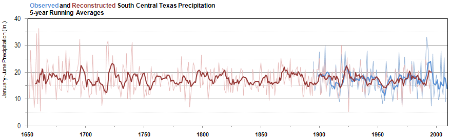
The tree-ring record, as a proxy for precipitation, can put the January-June precipitation variability of the last century in south central Texas into a much longer perspective. In the approximately 250-years prior to 1895, the tree-ring record shows about a dozen individual years that likely had very low January-June precipitation similar to the lowest values in the past century, such as 2008 and 2009. Looking at multi-year droughts, the 1950s drought appears to have been matched and possibly exceeded by one that occurred in the early 1700s (red bar), in which the ring-width index was below average for seven years in a row (1711-1717) and the cumulative ring-width anomaly for those seven years was slightly lower than for 1950-1956.
While the recent dryness in south central Texas has been extreme, the tree-ring record indicates that it is an uncommon but not extraordinary drought event -- the type that has occurred several times per century since at least 1650.
References:
- Griffin, R.D., C.A. Woodhouse, and D.W. Stahle, 2008. Russian River Valley precipitation and streamflow reconstructed from blue oak tree rings. Poster, Mountain Climate Conference. Jun 9-12, 2008, Silverton, CO.
- Griffin, R.D. 2007. A 600-Year Streamflow History in the Salinas Valley Reconstructed from Blue Oak Tree Rings. M.A. Thesis. U. of Arkansas, Fayetteville. 67 pages. (see http://treeflow.info/cali/salinas.html)
- Stahle, D.W. and M.K. Cleaveland, 1988. Texas drought history reconstructed and analyzed from 1698 to 1980. Journal of Climate 1: 59-74.
- Stahle, D.W., Griffin, R.D., Therrell, M.D., et al., 2009 (currently in press). The ancient blue oak woodlands of California. Fremontia (CNPS publication).
- Stahle, D.W., M.D. Therrell, M.K. Cleaveland, D.R. Cayan, M.D. Dettinger, and N. Knowles, 2001. Ancient blue oak reveal human impact on San Francisco Bay salinity. Eos, Transactions of the American Geophysical Union 82 (12) 141, 144-145.
- Therrell, M.D., 2000. The historic and paleoclimatic significance of log buildings in southcentral Texas. Historical Archaeology 34(2): 25-37.
Drought Indicators
- Palmer Drought Indices
- Standardized Precipitation Index
- long-term (36 to 60 month) percent of normal precipitation maps
- airport station percent of normal precipitation maps
- statewide precipitation rank maps
- Cooperative station percent of normal precipitation maps
- percent of average maps for the SNOTEL stations in the western mountains provided by the Western Regional Climate Center
- hydrologic year precipitation
- snow water equivalent of snowpack
- satellite-based observations of vegetative health
- National Weather Service model calculations of soil moisture, runoff, and evaporation
- National Weather Service model calculations of soil moisture using the Leaky Bucket Model
- Midwest Regional Climate Center model calculations of soil moisture
- topsoil moisture conditions observed by the USDA and mapped by the Climate Prediction Center
- pasture and range land conditions observed by the USDA and mapped by the Climate Prediction Center
- streamflow maps maintained by the USGS
Contacts & More Information