| Contents Of This Report: |
 |

|

|
|
|
The
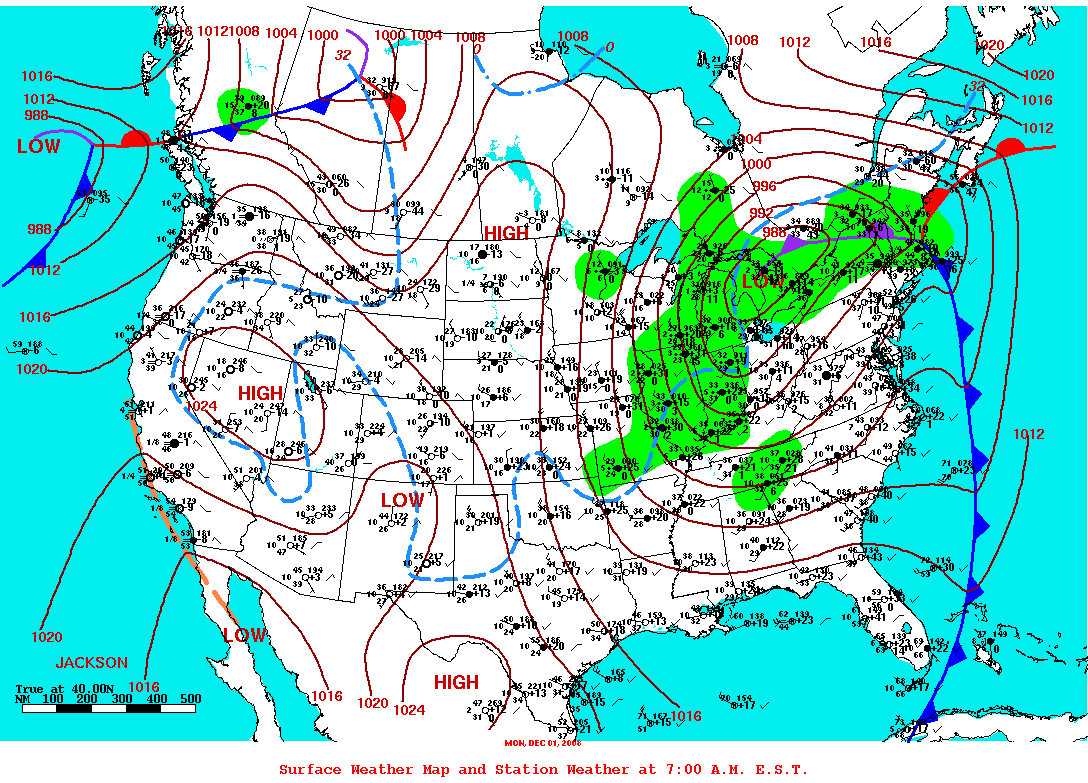 weather pattern
during December was very active with several
cold fronts and winter storm systems sweeping across the country,
especially the areas east of the Rockies. A low
pressure trough in the upper atmosphere dominated the north
central states, bringing colder-than-normal
airmasses to much of the western and north central U.S. The
combination of this cold air and moisture from the Pacific and Gulf
of Mexico resulted in above-average
snow for much of the country and beneficial
rain in the southeastern drought areas. Drier-than-average
weather occurred over the southern to central Plains and along
parts of the coastal Southeast. As a result, drought conditions
improved in the Southeast to Ohio Valley but intensified in
southern Texas (December 30
USDM versus December 2
USDM). weather pattern
during December was very active with several
cold fronts and winter storm systems sweeping across the country,
especially the areas east of the Rockies. A low
pressure trough in the upper atmosphere dominated the north
central states, bringing colder-than-normal
airmasses to much of the western and north central U.S. The
combination of this cold air and moisture from the Pacific and Gulf
of Mexico resulted in above-average
snow for much of the country and beneficial
rain in the southeastern drought areas. Drier-than-average
weather occurred over the southern to central Plains and along
parts of the coastal Southeast. As a result, drought conditions
improved in the Southeast to Ohio Valley but intensified in
southern Texas (December 30
USDM versus December 2
USDM). |
 |
 |
| December was drier than
normal across the southern and eastern portions of Puerto
Rico, with 2008
annual precipitation below normal in the southeastern portion,
but no drought was indicated for the island on the late December
USDM. Wet
weather dominated the Hawaiian Islands during the month,
resulting in contraction of drought conditions, especially over the
western islands (December 30
USDM versus December 2
USDM). But long-term rainfall deficits persisted over the
eastern islands for the
last six months and over all of the Hawaiian Islands for the
last
12 months. Much of southern and interior Alaska
was dry during December,
the last three months,
the last six months, and for
the year. Snowpack over
parts of southern Alaska was below-average as of the end of the
year. By the end of December, the core drought areas included:
|
| Soil moisture conditions improved in the Southeast by mid-December in the surface layers, but remained dry in the deeper layers. By the end of the month, soil moisture deficits continued across parts of the core drought areas in the West, southern Plains, western Great Lakes, and Southeast. Streamflow (both modeled and observed) improved in the Southeast but continued below average in parts of the other core drought areas. The impact of drought on vegetation is normally reduced this time of year due to seasonally colder weather, but the satellite-based Vegetation Health Index indicated stress to vegetation growing in southern Texas. |  |
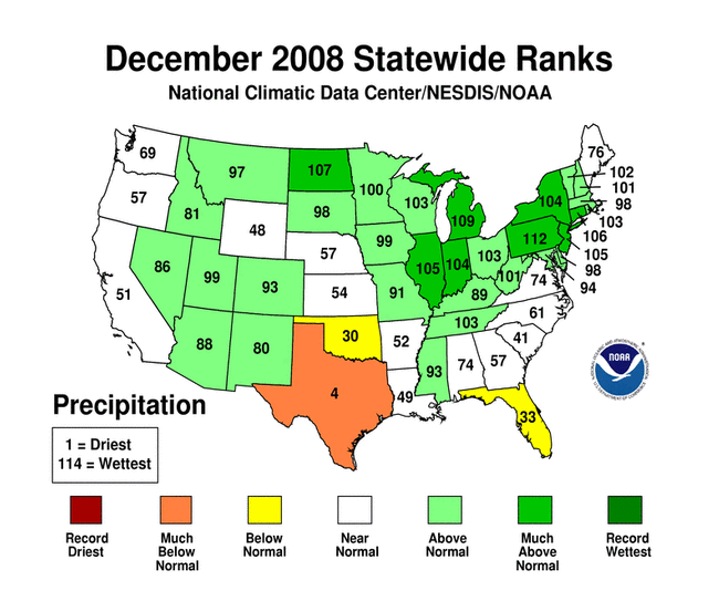 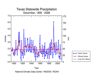 |
December 2008 ranked as the fourth driest December on record and marked the fourth consecutive month with below-normal precipitation for Texas. Extreme to exceptional dryness has occurred over parts of southern Texas for the last one, two, and three months, as measured by the Standardized Precipitation Index (SPI). This is part of a large area of dryness that covers much of the U.S. southern Plains southward across much of Mexico (2-month and 3-month percent of average precipitation maps). Lubbock, TX, reported blowing dust on several days in December (3, 8, 14, 23, 26, 27). The duststorms of December 8 and 14 were the most intense. According to a January 5 USDA report, Texas pasture and range land was very dry, and top soil moisture was mostly very short to adequate. The percentage of Texas wheat rated very poor to poor was 46 percent and, for oats, the percentage was 74 percent very poor to poor. Yields were generally low (with a few areas of good yields) for the cotton, sorghum, and pecan harvests. In Oklahoma, 20 percent of the winter wheat was rated very poor to poor. |
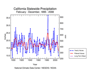
| Beneficial precipitation fell over parts of the western U.S. during December, giving much of the region a good start to the hydrologic year. Snowpack and snow water content improved in many areas, but reservoirs were still below normal for several western states as long-term precipitation deficits remained. California still ranked third driest on record for February-December 2008 and Nevada ranked seventh driest for March-December 2008. Overall drought conditions in the western U.S. (Rockies westward) improved from November to December. According to the Palmer Drought Index, about 44% of the region was in moderate to extreme drought at the end of the month, while the USDM had about 29% in moderate to exceptional drought and about 65% experiencing abnormally dry to exceptional drought conditions. The differences between the Palmer and USDM statistics are due to the extreme seasonality of precipitation in the West and other hydrologic components in the drought calculations. |
 |
 |
 |
 |
| Beneficial rains during the last half of 2008 helped reduce the intensity of drought in the Southeast. However, 2008 still ranked as a dry year for much of the area. The cumulative effect of the severe dryness in 2008 and 2007 resulted in low groundwater and reservoir levels which hadn't recovered by the end of 2008. Lake Lanier, in northeast Georgia, remained at record low levels for most of 2008. The 2-year period, January 2007-December 2008, ranked as the driest such 2-year period on record for western North Carolina (climate division 1) and Upstate South Carolina (climate division 2), and near-record dry for northwest Georgia (climate division 1), north central Georgia (climate division 2), northeast Georgia (climate division 3), eastern Tennessee (climate division 1), east central Tennessee (climate division 2), and southwestern Virginia (climate division 6). |
 
|
| A more detailed drought discussion, provided by the NOAA Regional Climate Centers and others, can be found below. |
|
|
|
According to the Southeast Regional Climate Center, there was much variability in the monthly precipitation totals across the region. Precipitation totals were below normal across most of Florida southeastern Georgia, North and South Carolina, as well as small portions of northern Virginia, central Georgia and southern Alabama. The area of greatest precipitation deficits included much of Florida and southeastern portions of Georgia and North and South Carolina, which received less than half of the normal precipitation for the month. In contrast, precipitation totals were above normal over portions of northwestern and southeastern Alabama, northern and southwestern Georgia, western South Carolina, western North Carolina and southern Virginia. Much of the precipitation for the month was associated with cyclones tracking across the Midwest and Great Lakes and pushing cold fronts through the area. An exceptionally strong cyclone developed along a stalled front and tracked northeastward from the Gulf Coast across the eastern slopes of the Appalachian on the 10th and 11th of the month. Many locations in the western and northern portions of the region received more than 2 inches of rain over this two day period. Most of Puerto Rico recorded precipitation totals that were below normal for the month. Above normal precipitation during the month contributed to a slight lessening of the drought persisting across northwestern South Carolina, extreme northeast Georgia, and extreme western North Carolina. Drought intensity lowered from the exceptional (D4) to the extreme (D3) category in this region. This marked the first time in six months that no area in the Southeast experienced exceptional drought conditions. Moderate (D1) drought conditions disappeared across northeast Alabama but continued across southwestern Virginia, portions of western North Carolina, and west central Florida. As noted by the Southern Regional Climate Center, December precipitation in the Southern Region was well below normal in the western states of Texas and Oklahoma, near-normal to slightly below normal in the central states of Arkansas and Louisiana, and well above normal in Tennessee and northern Mississippi. The driest area of the Southern Region included a large portion of north central Texas, where most stations reported less than 0.1 inch (2.54 mm) of precipitation. In fact, a majority of stations in Texas climate division 2 (Low Rolling Plains) did not record any precipitation for the entire month. Throughout Texas, most stations reported 50 percent or less of the monthly average. Similar conditions occurred in western and central Oklahoma. In Arkansas, only the eastern counties received near-normal precipitation. Conditions in the remainder of the state were dry, with most stations reporting between 50-90 percent of the monthly normal. In Louisiana, conditions were dry in the south and northwestern portions of the state. Central parishes did observe near-normal precipitation. In Mississippi, precipitation was generally well above normal, particularly in the central and northern counties. Within those regions, precipitation totals varied from 130 to over 200 percent of normal. In Tennessee, similar conditions were observed with much of the state enjoying a very wet month for a change, including the eastern counties where drought had been persistent for many months. Drought conditions in the Southern Region changed slightly compared to November. Below normal precipitation led to a slight deterioration of drought conditions and expansion of the area of exceptional drought in south central Texas. Conversely, above normal precipitation in Tennessee resulted in significant improvement in drought conditions: extreme drought improved to just moderate drought in the eastern portion of the state, and the central counties in the state that were observing moderate to severe drought were drought-free by the end of December. As reported by the media (San Antonio Express-News, 12/18), many streams and rivers in central Texas were below 10 percent of normal flow, causing reservoir levels to continue to fall. Precipitation in San Antonio during the 15-month period through November 2008 was the lowest in any similar period since recordkeeping began in 1871. The drought has resulted in reduced yields for dryland cotton and wheat crops (San Angelo Standard Times, 12/18) As explained by the Midwest Regional Climate Center, December was a cold and wet month for most of the Midwest. Precipitation ranged from near normal in southwestern Missouri to much above normal in the upper Midwest. In Kentucky, December was the first month since July with above normal precipitation, which helped to alleviate the drought conditions that have persisted in the state. As noted by the High Plains Regional Climate Center, precipitation varied quite a bit across the region this month as there were widespread areas of both above and below normal precipitation. Dry locations which received less than 50 percent of normal precipitation included much of Wyoming, Colorado, Nebraska, and Kansas, and pockets of eastern South Dakota and north central North Dakota. Areas experiencing drought did not get any relief this month as drought conditions have remained largely unchanged across the region. For instance, the Rawlins Municipal Airport in Wyoming recorded no precipitation and tied the record for driest December (last set in 2001). Areas that received at least 150 percent of normal precipitation include North Dakota, South Dakota, the western half of Colorado, the northwestern part of Wyoming, and small pockets of Nebraska. The USDM remained largely unchanged compared to November. Moderate drought (D1) persisted in southwest North Dakota, southwest Wyoming, and southeast Colorado. Kansas: According to the Kansas State Water Office, the dry conditions experienced during November 2008 persisted throughout December in central and western Kansas. The December 30 USDM showed lingering abnormally dry or moderate drought conditions across part of far-western Kansas and a sliver of abnormally dry conditions along the Oklahoma border in south central Kansas. The longer-term precipitation pattern showed persistent dryness in southwest Kansas at 12 months. According to the January 5, 2009, Kansas Crop and Weather Report, 19 percent of statewide topsoil moisture, and 16 percent of statewide subsoil moisture, were rated short to very short (dry to very dry). All reservoirs were near or above the top of their conservation/multi-purpose pool with the exception of Norton and Cedar Bluff reservoirs which were 10.4 and 16.5 feet down, respectively. There were no reports of drought-related public water system impacts. As summarized by the Western Regional Climate Center, there was no discernable pattern to precipitation in December. Much of the Southwest and northern Plains were well above normal while the Pacific Northwest and most of Wyoming and southern New Mexico were below normal. Although precipitation was only 60-75 percent of normal in northwest Washington, this was the snowiest month in 13 years at lower elevations. Winter finally reached the Sierra Nevada at mid-month. Through December 12, New Orleans, LA had measured more snow than Lake Tahoe (Tahoe City), CA, but that changed quickly. By the end of the month, the Sierra Nevada snowpack had risen from 3 percent of normal on the first to 85 percent of normal on the 31st. Most of Hawaii had an extremely wet month with Hilo recording its wettest December since 1971 (30.38 in, 772 mm). Western snowpack ranged from over 200 percent of normal in parts of the Southwest on January 1, 2009, to slightly below normal in the Sierra of California (85 percent) and the Pacific Northwest (90 percent) to near normal in the Intermountain West (90-110 percent). For calendar year 2008, most of the Pacific Northwest and the Intermountain region had slightly below normal temperatures while most of the Southwest and California was slightly above normal. Almost the entire region had below normal precipitation except for parts of Montana and Wyoming. The 21.70 inches (553 mm) in Redding, CA, for 2008 was the driest year since 1976. This followed the 21.75 inches measured in 2007. Other Reports: The end-of-December below-average Sierra Nevada snowpack prompted concerns by the state meteorologist that California may be facing a third consecutive year of drought (California Water News, 1/2/09). Local USDA reports indicated that parts of northern California (Shasta, Tehama, Butte, Glenn and Colusa Counties) had below normal streamflows and little to no livestock water. Springs in Shasta county have gone dry for the first time in 60 years and rainfall for the start of their wet season was at historic lows. The lack of precipitation has halted the growth of livestock feed and has significantly increased costs to livestock operations. Alaska: According to National Weather Service reports (from information compiled and provided by Audrey Rubel at NOAA NWS Alaska Region Headquarters), December precipitation was below normal at Cold Bay, Fairbanks, Juneau, and Yakutat; near normal at Anchorage, Barrow, Kodiak, and Nome; and above normal at Bethel and St. Paul. Where snowfall data was available, snow totals for southeast Alaska in December were well above normal, ranging from 57 percent above normal in northern locations to as much as 170 percent above normal for southern panhandle locations. Northern and central inner channel locations received a majority of their snowfall and southern locations received the overwhelming majority of their snowfall during the last week of the month as a result of several significant weather systems that impacted the panhandle. Total precipitation was, however, uniformly below normal across southeast Alaska with deficits ranging from 28 percent to 55 percent. Precipitation was bi-modally distributed across the panhandle, falling in the first 11 days, and then again in the last week. The dry spell in the middle corresponded to an Arctic outbreak with very strong high pressure over the Yukon and British Columbia. The strong high pressure over Canada and the resultant northeasterly pressure gradient also resulted in sustained strong winds during the second and third weeks of the month over the far northern inner channels near Skagway and, less consistently, all along the coastal mountains from Juneau to Misty Fjords. Accumulated annual precipitation for southeast Alaska was a mixed bag. Far northern locations finished the year around 20 inches (13 percent) below normal. Central outer coastal and southern locations finished the year with near normal accumulated precipitation. The central inner channels recorded around 16 inches (28 percent) above normal annual precipitation. As noted by the Northeast Regional Climate Center, the Northeast's average precipitation total was 4.90 inches (12.45 cm), making this month the tenth wettest December since 1895. Among the states in the region, it was the third wettest in Pennsylvania, the ninth wettest in Connecticut and the tenth wettest in New Jersey. In spite of the wet conditions in the Northeast, the USDM indicated that portions of northwest Pennsylvania remained abnormally dry and the southern half of West Virginia continued to experience moderate drought conditions as of December 30, 2008. Several states fell within the top ten wettest on record in 2008, including New Hampshire, where it was the wettest year since statewide records began in 1895. With a precipitation total of 49.68 inches (126.19 cm), the Northeast had its fourth wettest year in 2008. |
|
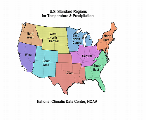
| A detailed review of
drought and moisture conditions is available for all contiguous U.S.
states, the nine standard regions, and
the nation (contiguous U.S.): STATES: REGIONS:
|
|