| Contents Of This Report: |
 |

|

|
|
|
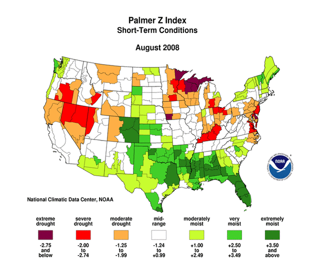
The weather pattern during August
consisted of a storm track near the U.S.-Canadian border with
high
pressure dominating the southern U.S. during the first half of
the month. Weak cold fronts moved across the Pacific Northwest
states then east of the Rockies throughout the month. An
upper-level low pressure system slowly rotated across the central
U.S. at mid-month, bringing below-normal
temperatures and areas
of rainfall to the central and southern Plains. Tropical systems brought beneficial
rains to the drought areas of the Southeast and southern Plains
(September
2 USDM versus July 29 USDM)
early in the month (Tropical Storm Edouard) and again later in the
month (Tropical Storm Fay). August was generally dry across much of the western Great Lakes and Upper Mississippi Valley, Ohio Valley, Alaska, and Hawaii, and parts of the West, northern Rockies, mid-Atlantic coast to Northeast, and eastern Puerto Rico. The persistent dryness has resulted in
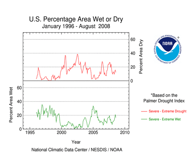
 While abundant rainfall this month gave many Gulf Coast states a top ten wettest August precipitation rank, precipitation deficits over the last 12 months have been substantial. September 2007-August 2008 deficits were still 10 to 20 inches over parts of the western Carolinas to northern Alabama even after the 5 to 9 inches of rainfall from Tropical Storm Fay, with extreme to exceptional drought persisting in the western Carolinas. The last 12 months ranked as the 23rd driest for North Carolina and 31st driest for South Carolina and Virginia. The percent area of the Southeast experiencing moderate to extreme drought has decreased significantly from its peak of a year ago. But early September groundwater and streamflow levels remained low across parts of the Carolinas, and soil moisture in the deeper layers still struggled to recover. Prior to Fay's rainfall, several streams in western North Carolina set record low flows and springs in eastern Tennessee had dried up.  |
Several Great Lakes to
Ohio Valley states had the tenth
driest, or drier, August on record. Kentucky ranked third
driest, Wisconsin sixth,
and Ohio seventh.
This was a marked change from the unusual wetness of the previous
several months (February-July,
March-August,
September-August).
Streamflows
were low, soil moisture (root
zone,
total column, CPC
modeled,
UW modeled,
USDA topsoil) was dry, and
pastures and rangeland were in
poor to very poor condition, especially in the western Great
Lakes and Upper Mississippi Valley.
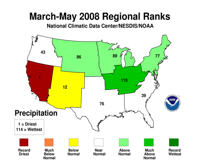
  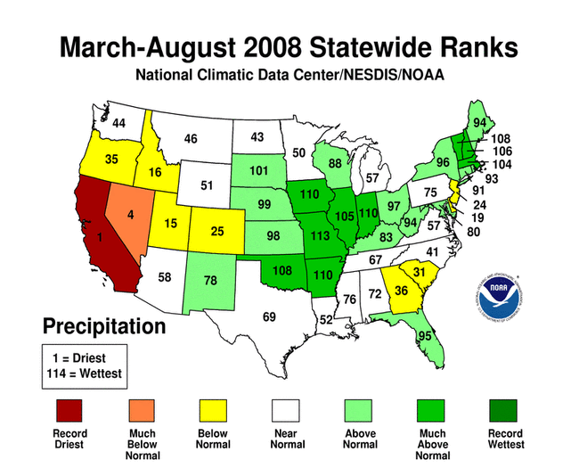 June-August 2008 was the 11th driest summer for the West region. But the summer months are normally the dry season for the West. Spring (March-May) includes the last part of the wet season, and this spring was also dry. The compounded effects of the persistent spring-summer dryness have resulted in California having the driest March-August in the 114-year record, Nevada the fourth driest March-August, Idaho the 13th driest April-August, and Utah the 15th driest March-August. 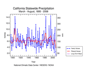 A more detailed drought discussion, provided by the NOAA Regional Climate Centers and others, can be found below. |
|
|
|
According to the Southeast Regional Climate Center, in contrast to prior months, over three-quarters of the region received above normal rainfall during August. Huntsville, AL recorded above normal monthly precipitation for the first time since October 2006, a stretch of 21 months. Most of Florida and Alabama as well southern Georgia, central North Carolina and portions of southern Virginia received more than 150% of the normal precipitation for the month. Much of this precipitation was connected with Tropical Storm Fay, who tracked slowly across Florida, southern Alabama, and Mississippi between August 18 and 23 before weakening into a tropical depression and moving slowly northeastward into eastern Tennessee and Kentucky by August 27th. Drought conditions persisted across portions of the region during the month of August. The heavy rainfall, however, reduced the drought intensity in most places by the end of the month. Exceptional drought conditions continued to plague northwestern South Carolina, northeast Georgia and western North Carolina. Fay's rainfall, however, reduced the intensity of the drought slightly over all but northwestern South Carolina. A broad area of severe to extreme drought persisted across eastern Alabama, Georgia, South Carolina, North Carolina, and Virginia, although Fay's rainfall reduced its intensity over much of the region, except for southeastern Virginia and northeastern North Carolina. Western North Carolina Streamflows: According to the USGS, on August 10 (before the beneficial rains from Tropical Storm Fay), streamflow in the French Broad River at Asheville, NC reached the lowest level since 1895 when the U.S. Geological Survey first began making measurements at the site. Record minimum streamflows were also recorded in the Yadkin, Catawba, and Broad River basins of North Carolina. The low August streamflows continued a trend that had lasted all summer through mid-August: monthly average streamflows were at all-time record lows for the months of June and July at more than half of the USGS long-term streamflow gages in western North Carolina. As noted by the Southern Regional Climate Center, drought conditions generally improved over last month. Tropical Storm Edouard helped alleviate drought conditions over much of southeastern and central Texas. A two-category improvement in drought conditions also occurred in the Oklahoma panhandle. In Louisiana, Mississippi and Tennessee, Tropical Depression Fay helped eradicate dry conditions. Specifically, severe drought in central and northern Louisiana was eliminated. Similarly, moderate drought, which was present in northeastern Mississippi, disappeared. As explained by the Midwest Regional Climate Center, August was a very dry month across the Midwest. Precipitation was below normal across the entire region, with only a few isolated areas receiving near normal rainfall. In those areas that did receive normal rainfall, much of the rain was not spread out across the month but came during one or two events. Rainfall in August was less than 25% of normal from northern Minnesota through northern Wisconsin into northwestern Ohio, as well as the Ohio Valley. The only area to receive normal to above normal rainfall was extreme southern Missouri and parts of central Missouri. For most of the region, August rainfall totals were well below two inches (5.1 cm). By the end of the month, the U.S. Drought Monitor depicted areas of Moderate Drought (D1) in Minnesota, Wisconsin, and southeastern Kentucky. Abnormal Dryness (D0) expanded across Ohio, Michigan, and Wisconsin. As noted by the High Plains Regional Climate Center, August 2008 was dry for portions of central and eastern Nebraska, western Colorado, northern Wyoming, and the Dakotas. As drought conditions continued in Wyoming, the paucity of precipitation in eastern Nebraska and South Dakota helped contribute to the development of abnormally dry and moderate drought conditions. However, heavy rains in eastern Colorado and western Kansas helped alleviate drought conditions there, with many locations receiving 150-300% of normal precipitation. Extreme to exceptional drought conditions across the Colorado-Kansas border improved to moderate to severe conditions. As summarized by the Western Regional Climate Center, precipitation was above normal in western Washington and northwest Oregon, northern Idaho and eastern Colorado while most of the intermountain West was below normal except for isolated pockets in Utah and the Southwest. California: According to the California Department of Water Resources (www.water.ca.gov/drought), the reservoirs in the central and northern areas were below normal for this time of year (gif image, pdf*). Statewide average reservoir levels were 75% of the long-term average for the end of August, but the droughts of 1976, 1977, and 1992 had lower reservoir levels (gif image, pdf*).
The month was unusually dry at Kotzebue, Nome, and Barrow, as high pressure dominated the weather pattern. Measurable rainfall was recorded on thirteen days at Nome, with an average daily amount of only 0.02 inch. The total precipitation for August was 0.56 inch, which is 2.67 inches below average. The total rainfall for the month at Barrow was 0.30 inch, tying with 1933 for the sixth driest August on record. August snowfall at Barrow totaled a trace, well below the monthly normal of 0.7 inch. The areal coverage of Arctic sea ice for the month was well below the long term average, but not as low as in 2007. As noted by the Northeast Regional Climate Center, the northern states were wetter than the southern half of the region in August, but not as wet overall as last month. In fact, the Northeast averaged below normal precipitation this month. The region's average rainfall total of 3.57 inches (9.07 cm) was 90% of normal. New Hampshire and Vermont saw the most rain, 127% and 118% of normal, respectively. It was the driest August in 114 years in Delaware, where only 0.99 inches (2.51 cm) of rain fell. Delaware's August total was 3.64 inches (9.25 cm) below normal. While the summer rainfall averaged above normal (111% of normal) in the Northeast, two states, New Jersey and Delaware, saw a very dry June, July and August. With only 62% of normal rainfall, it was the 9th driest summer in Delaware since 1895. New Jersey was close behind, with 73% of the normal summer rain total. The U.S. Drought Monitor issued on September 2, 2008 indicated that the southernmost part of New Jersey and West Virginia, most of Delaware, eastern Maryland and a small area in north central Pennsylvania were experiencing moderate drought conditions. The rest of New Jersey, central and southeastern Pennsylvania, central Maryland and southern West Virginia were abnormally dry. In contrast, Maine, New Hampshire, Vermont, Connecticut, eastern New York, western Pennsylvania and all but coastal Massachusetts were in the unusual or very moist categories of the Palmer Drought Severity Index. |
|
| A detailed review of
drought and moisture conditions is available for all contiguous U.S.
states, the nine standard regions, and
the nation (contiguous U.S.): STATES: REGIONS:

|
|