U.S. Drought Highlights:
- On the national scale:
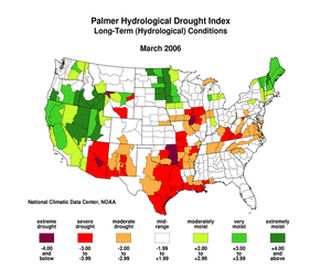
- Severe to extreme drought affected about 13 percent of the contiguous United States as of the end of March 2006.
- Moderate to extreme drought affected about 26 percent of the contiguous U.S.
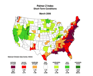
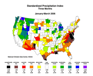
- Dryness affected many of the same areas this month that have experienced dry conditions during the last several months (February, January, December, November). March was much drier than normal along the Atlantic and Gulf coasts. About 14 percent of the contiguous U.S. was very dry (i.e., precipitation in the bottom 10th percentile of the historical record).
- Above-normal precipitation continued to bring improvement to parts of the Rockies and central and southern Plains. During the month, beneficial rains brought relief to the drought area in northeast Texas, southeast Oklahoma and western Arkansas, and rain and snow brought relief to Nebraska and eastern Wyoming, but it was not enough to compensate for the significant deficits of the last 12 months.
- Dryness intensified and spread along the Atlantic and Gulf coasts. For the last three months drought had been concentrated in the middle Atlantic states and in southern Louisiana, but the areas of dryness were spreading. Long-term moisture deficits persisted across most of the Mississippi Valley, central and eastern Texas, and the Southwest. Another area of long-term deficits was in the central Appalachians.
Please Note: The data presented in this drought report are preliminary. Ranks, anomalies, and percent areas may change as more complete data are received and processed.
National Overview
On the national scale,
- severe to extreme drought affected about 13 percent of the contiguous United States as of the end of March 2006, a decrease of about 2 percent compared to last month
- about 26 percent of the contiguous U.S. fell in the moderate to extreme drought categories (based on the Palmer Drought Index) at the end of March
- on a broad scale, the previous two decades (1980s and 1990s) were characterized by unusual wetness with short periods of extensive droughts, whereas the 1930s and 1950s were characterized by prolonged periods of extensive droughts with little wetness
- about 14 percent of the contiguous U.S. fell in the severely to extremely wet categories at the end of March
- a file containing the national monthly percent area severely dry and wet from 1900 to present is available
- historical temperature, precipitation, and Palmer drought data from 1895 to present for climate divisions, states, and regions in the contiguous U.S. are available at the Climate Division: Temperature-Precipitation-Drought Data page in files having names that start with "drd964x" and ending with "txt" (without the quotes).
Regional Overview
Dryness affected many of the same areas this month that have experienced dry conditions during the last several months (February, January, December, November). March was much drier than normal along the Atlantic and Gulf coasts. About 14 percent of the contiguous U.S. was very dry (i.e., precipitation in the bottom 10th percentile of the historical record).
Above-normal precipitation continued to bring improvement to parts of the Rockies and central and southern Plains. During the month, beneficial rains brought relief to the drought area in northeast Texas, southeast Oklahoma and western Arkansas, and rain and snow brought relief to Nebraska and eastern Wyoming, but it was not enough to compensate for the significant deficits of the last 12 months.
The March precipitation pattern at the primary stations in Alaska was dry in the interior and along the southeast panhandle. Across Hawaii, the precipitation pattern was wet most everywhere. In Puerto Rico, the month was predominantly wet, based on National Weather Service radar estimates of precipitation. March streamflow averaged near normal for Puerto Rico and the Hawaiian Islands.
Dryness intensified and spread along the Atlantic and Gulf coasts. For the last three months drought had been concentrated in the middle Atlantic states and in southern Louisiana, but the areas of dryness were spreading. Long-term moisture deficits persisted across most of the Mississippi Valley, central and eastern Texas, and the Southwest. Another area of long-term deficits was in the central Appalachians.
Some regional highlights:
- Several states had the tenth driest, or drier, March and also for multi-month seasons (January-March, October-March, April-March and others).
- Record-setting dry conditions were reported at several stations from Virginia through New York and in Florida.
- Numerous wildfires during the month burned across several states in the central and southern Plains, southern Appalachians, and adjoining parts of the Tennessee and Ohio valleys. The fires were especially widespread during the early part of March.
- End-of-month and month-averaged soil moisture conditions, based on model computations (CPC-1, CPC-2, MRCC), were drier than normal across a broad swath from the southern and central Plains to the Atlantic coast. A separate area of dry soil moisture conditions extended into the southwestern U.S. The models also indicated dry soil moisture conditions in parts of Alaska, and near the surface and at depth across parts of the Midwest.
- Streamflow levels reflected the March precipitation pattern. March streamflows were below seasonal norms across much of the East, and parts of the central Plains and the Southwest, as computed by models and based on USGS observations.
- Drought conditions in the Southwest continued during March. About 21 percent of the western U.S. (Rockies westward) fell in the moderate to extreme drought category (as defined by the Palmer Drought Index) as of the end of March. Aggregated reservoir levels in the West (provided by the USDA) reflected the long-term precipitation deficits in most states.
Paleoclimatic Perspectives
March 2006, Pre-Instrumental Perspective, Southeast Arizona
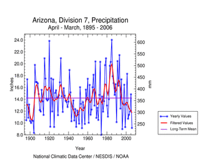
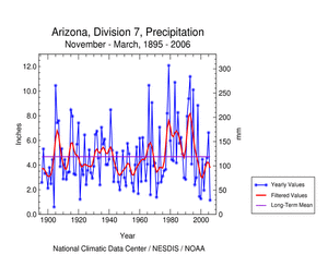
Arizona has been experiencing very dry conditions for much of the last seven years. The southeast corner of the state (climate division 7) has been especially hard hit. Arizona Division 7 had the second driest winter (November-March) and fifth driest year (April-March) in the 1895-2006 historical record.
Even after much-needed rains in March, most of Arizona and adjoining New Mexico was still experiencing one of worst winter droughts on record. This return to dry conditions for the region comes after a very wet winter in 2004-2005 which provided some recovery from the severe multi-year drought of 1999-2004. The southern parts of both states received less relief from the March storms than areas to the north, and most of Arizona division 7 was still classified as "extreme drought" on the late March to early April U.S. Drought Monitor.
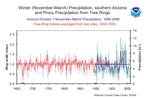
The graph below (annual values in light blue, 5-year weighted average in dark blue) shows the winter (November- March) precipitation, 1896-2006, for Arizona Division 7. The value for 2006 (1.15 inches) is the lowest since 1904, although several other years were similarly low. The 1999-2004 drought (indicated with the yellow bar) had six winters in a row with precipitation below the long-term mean, which had not occurred since 1898-1904 (orange bar).
The graph to the left also shows a 343-year tree-ring record (1650-1992; annual values in light red; 5-year smoothed values in dark red) that corresponds well to the variability in November-March precipitation. This record is the average of two Douglas-fir tree-ring chronologies from southeast Arizona. These ring-width chronologies are unusual in that they are based on only part of the annual growth ring, the "earlywood", which closely reflects the influence of winter precipitation. The chronologies were developed by Meko and Baisan (2001), who used the other part of the annual ring ("latewood") of these same trees to reconstruct variability in summer precipitation. The correlation between the annual values of the tree-ring record and November-March precipitation is 0.698, indicating a high degree of shared variance.
The tree-ring record, as a proxy for precipitation, can put the winter precipitation variability of the last century in southeast Arizona into a much longer perspective. The record shows a handful years in the approximately 250-year period prior to 1895 that may have had very low winter precipitation similar to that of 2006; these extreme winter droughts appear to have been less frequent than in the last 100 years. The most severe and persistent multi-year periods of winter drought in the instrumental record (1898-1904 and 1999-2004) appear to have been matched or exceeded only once, in 1666-1673 (red bar). A 992-year reconstruction of November-April precipitation for Arizona Division 7, using an independent set of tree-ring data (Ni et al. 2002), confirms this assessment, and further suggests that the 1660s was the most severe and persistent period of winter drought since 1000 AD. The current winter drought, and the recent multi-year drought — which could be resuming after a one-year hiatus — are likely among the most severe events of their kind in the past 350 years.
Resources:
- Divisional climate data, including precipitation for Arizona Division 7 as shown above, can be obtained from NCDC.
References:
- Meko, D. M., and Baisan, C. H., 2001. "Pilot study of latewood-width of conifers as an indicator of variability of summer rainfall in the North American Monsoon region." International Journal of Climatology 21: 697-708.
- Ni, F., Cavazos, T., Hughes, M. K., Comrie, A. C. and Funkhouser, G. 2002. "Cool-season precipitation in the southwestern USA since AD 1000: Comparison of linear and nonlinear techniques for reconstruction." International Journal of Climatology 22: 1645-1662.
 NOAA's National Centers for Environmental Information
