U.S. Drought Highlights:

- On the national scale, severe to extreme drought affected about 6 percent of the contiguous United States as of the end of October 2005.
- Moderate to extreme drought affected about 18 percent of the contiguous U.S.
- The month was much drier than normal across a broad swath of the country from the Great Lakes to the Deep South, with 12 percent of the contiguous U.S. very dry (in the bottom 10th percentile of the historical record). Parts of the West were also drier than normal.
- Heavy October precipitation ended the dryness in the Northeast.
- The October dryness aggravated long-term drought in the southern Plains to Lower Great Lakes (2 to 6 to 9 months). Long-term moisture deficits (last 24 to 36 to 60 months) persisted across parts of the West into the northern High Plains and central Plains.
Please Note: The data presented in this drought report are preliminary. Ranks, anomalies, and percent areas may change as more complete data are received and processed.
National Overview
On the national scale,
- severe to extreme drought affected about 6 percent of the contiguous United States as of the end of October 2005, about the same as last month
- about 18 percent of the contiguous U.S. fell in the moderate to extreme drought categories (based on the Palmer Drought Index) at the end of October
- on a broad scale, the previous two decades (1980s and 1990s) were characterized by unusual wetness with short periods of extensive droughts, whereas the 1930s and 1950s were characterized by prolonged periods of extensive droughts with little wetness
- about 14 percent of the contiguous U.S. fell in the severely to extremely wet categories at the end of October
- a file containing the national monthly percent area severely dry and wet from 1900 to present is available
- historical temperature, precipitation, and Palmer drought data from 1895 to present for climate divisions, states, and regions in the contiguous U.S. are available at the Climate Division: Temperature-Precipitation-Drought Data page in files having names that start with "drd964x" and ending with "txt" (without the quotes).
Regional Overview
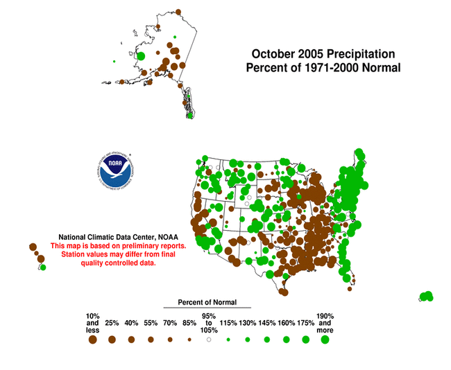
October 2005 was much drier than normal across a broad swath of the country from the Great Lakes to the Deep South, with 12 percent of the contiguous U.S. very dry (in the bottom 10th percentile of the historical record). Parts of the West were also drier than normal. Record wet October precipitation ended the dryness in the Northeast.
The October precipitation pattern at the primary stations in Alaska was drier than average in the southeast (north of the panhandle), and mixed elsewhere. Across Hawaii, the precipitation pattern was mixed, with more stations drier than average than wetter. In Puerto Rico, the precipitation signal was also mixed, based on National Weather Service radar estimates of precipitation. October streamflow averaged wetter than normal for Puerto Rico and the Hawaiian Islands.

The October dryness aggravated long-term drought in the southern Plains to Lower Great Lakes (2 to 6 to 9 months). Long-term moisture deficits (last 24 to 36 to 60 months) persisted across parts of the West into the northern High Plains and central Plains.
Some regional highlights:
- Several states had the tenth driest, or drier, month in October and also for multi-month seasons (May-October and others). These states include:
- Several stations in the Great Lakes and Deep South had record or near record dry conditions.
- During October, several counties in northeast Texas were declared disaster areas by the U.S. Department of Agriculture. Dropping well levels and below normal rainfall prompted the Barton Springs/Edwards Aquifer Conservation District's board to declare a stage one drought alert for the Barton Springs segment of the Edwards Aquifer in Texas. The Buda and San Leanna monitor wells fell below their stage one trigger levels with ground water levels in other area wells also declining.
- By the end of the month, 60% or more of the pasture and range land was in poor to very poor condition in Arizona (60%), Arkansas (63%), Louisiana (76%), California (84%), and Mississippi (85%). Relative to "normal", pastures and range land were anomalously dry across much of the South to Great Lakes, and parts of the West.
- End-of-month and month-averaged soil moisture conditions were drier than normal across a broad swath from the southern Plains and Southeast to the central Plains and Great Lakes, and parts of the interior mid-Atlantic states, Pacific Northwest, and Rockies, based on model computations (CPC-1, CPC-2, MRCC). The models also indicated dry soil moisture conditions in parts of Alaska, and near the surface and at depth from Iowa to the western Great Lakes.
- According to end-of-October USDA observations, more than 50 percent of the topsoil moisture was rated short to very short (dry to very dry) across the Deep South to the southern Rockies, and parts of the Ohio Valley to Great Lakes and Pacific Northwest states. This is drier than the 5-year and 10-year averages across much of the area.
- Streamflow levels were below seasonal norms across much of the Deep South to Great Lakes states, and parts of the Pacific Northwest, central Plains, and northern Rockies, as computed by models and based on USGS observations.
- Wildfire activity in Alaska and the western U.S. subsided during October, but several blazes flared up east of the Rockies.
- Reservoir levels in the West (provided by the USDA) reflected the long-term precipitation deficits in many states. About 16 percent of the western U.S. (Rockies westward) fell in the moderate to extreme drought category (as defined by the Palmer Drought Index) as of the end of October, reflecting continued dryness in the Pacific Northwest.