U.S. Drought Highlights:

- On the national scale, severe to extreme drought affected about 5 percent of the contiguous United States as of the end of May 2005.
- Moderate to extreme drought affected about 8 percent of the contiguous U.S.
- May was the third wetter-than-normal month across parts of the Pacific Northwest, following a dry winter in the region.
- The month was drier than normal in the southern Plains to the Great Lakes eastward to the Appalachians and Northeast.
- Long-term moisture deficits (last 24 to 36 to 60 months) persisted across much of the West into the northern High Plains and central Plains.
Please Note: The data presented in this drought report are preliminary. Ranks, anomalies, and percent areas may change as more complete data are received and processed.
National Overview
On the national scale,
- severe to extreme drought affected about 5 percent of the contiguous United States as of the end of May 2005, a decrease of about 1 percent compared to last month
- about 8 percent of the contiguous U.S. fell in the moderate to extreme drought categories (based on the Palmer Drought Index) at the end of May
- on a broad scale, the previous two decades (1980s and 1990s) were characterized by unusual wetness with short periods of extensive droughts, whereas the 1930s and 1950s were characterized by prolonged periods of extensive droughts with little wetness
- about 24 percent of the contiguous U.S. fell in the severely to extremely wet categories at the end of May
- a file containing the national monthly percent area severely dry and wet from 1900 to present is available
- historical temperature, precipitation, and Palmer drought data from 1895 to present for climate divisions, states, and regions in the contiguous U.S. are available at the Climate Division: Temperature-Precipitation-Drought Data page in files having names that start with "drd964x" and ending with "txt" (without the quotes).
Regional Overview
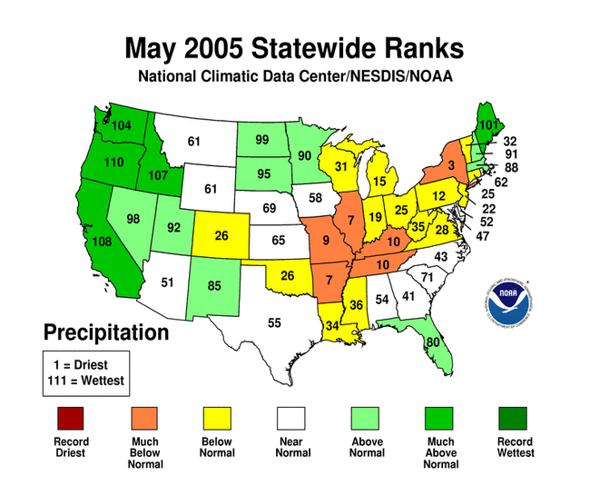
May was the third wetter-than-normal month across parts of the Pacific Northwest, following a dry winter in the region. The month was drier than normal in the southern Plains to the Great Lakes eastward to the Appalachians and Northeast.
The May precipitation pattern at the primary stations in Alaska was mixed and mostly drier than average for Hawaii. In Puerto Rico, the precipitation signal was mixed during May, based on National Weather Service radar estimates of precipitation. May streamflow averaged near normal for Puerto Rico and dry for the Hawaiian Islands.
Long-term moisture deficits persisted in many areas. Six-month dryness was evident for parts of the Northwest, South and Southeast. The Pacific Northwest has experienced a dry winter followed by a wet spring, though spring excesses did not significantly ease six to seven years of precipitation deficits.
The southwestern U.S. has been very wet during the winter and spring though long-term deficits remain across parts of the Southwest and West, and much of the central to northern Plains. These are reflected in the end of May U.S. Drought Monitor map. The Southwest has recovered at the 12 to 24 month timescales, but still shows dryness in some parts at the 36 to 60 month timescales.

Parts of the central U.S. have been persistently dry for the spring, with states from Texas to Pennsylvania showing dryness at the 3-month timescale. Both Michigan and Illinois ranked 3rd driest on record for the spring.
Some regional highlights:
- Seven states had the tenth driest, or drier, spring (March-May) on record.
- Six states had the tenth driest, or drier, May on record.
- End-of-month and month-averaged soil moisture conditions were drier than normal across parts of the northern Rockies and northern High Plains, the central Plains, the Pacific Northwest, and the Lower Mississippi Valley, based on model computations (CPC-1, CPC-2, MRCC). The models also indicated dry soil moisture conditions in eastern Alaska and near the surface and at depth across parts of the central Plains to the Great Lakes.
- Streamflow levels were below seasonal norms across northern parts of the Pacific Northwest, northern Rockies, and parts of the Lower Mississippi Valley and southern Plains, both as computed by models and based on USGS observations.
- In contrast to the sharp north-south gradient in moisture receipt during the winter for the West, the spring saw above-average precipitation fall across much of the western U.S. However, snow water content in the Northwest still reflected the lack of winter precipitation. Basin-averaged end-of-May snowpacks in parts of central California and Utah remained above average, contrasting with snowpacks in Oregon, Washington, Idaho, Montana and Wyoming. This pattern is also apparent in basin-averaged water-year-to-date precipitation anomalies.
Reservoir levels in the West reflected the abundance (Arizona) or lack (many other states) of precipitation, or preventative actions taken by water managers in anticipation of summer shortfalls (Washington). The percent area of the western U.S. (Rockies westward) experiencing moderate to extreme drought (as defined by the Palmer Drought Index) decreased from about 67% in July 2004 to under 10% by October. Intensification of drought in the Pacific Northwest (Nov., Dec., Jan., Feb., Mar., Apr.) resulted in an expansion of the western drought area to about 26% by the end of February. Above-normal precipitation from storms during the last several months in the Pacific Northwest brought the western area coverage down to near 11% by the end of May.
Paleoclimatic Perspectives

Over the last three decades, November-May precipitation in Oregon's Division 7 has experienced large swings from dry (1975-77) to wet (1982-84) to dry (1990-92) to wet (1996-98) and back to dry (2000-03) (see graph to left). When the annual values are smoothed with a 5-year weighted average (blue line in graph below), these multi-year oscillations appear to have greater amplitude than those in the preceding 80 years of instrumental record.

The graph to the right also shows a millennial-length tree-ring record (1000-1996) that corresponds well to the variability in November-May precipitation (red line; 5-year weighted average of annual values). This record is the average of three tree-ring chronologies from central Oregon. The growth of the western juniper trees at these sites is influenced mainly by the moisture in the soil at the start of the growing season, delivered by storms the previous winter and spring. The correlation between annual values of the 3-chronology average and of November-May precipitation is 0.734, indicating a high degree of shared variance.
The tree-ring record, as a proxy for precipitation, can put the variability of the last 30 years into a much longer perspective. While there is no exact analog for recent conditions, the tree-ring record shows periods in which there were similarly large oscillations, such as in the early 1200s, early 1400s, late 1500s, and mid-1700s. There are also long periods in which the amplitude of variability was generally lower, most notably 1800-1900. Also, there are a number of dry anomalies that match or exceed the extremes in the instrumental records, the most severe around 1071, 1352, and 1580. Another severe dry event in the mid-1600s has two closely separate peaks (1644, 1652). More recent significant dry events occurred around 1737, 1794, and 1844, the last one being less severe but more sustained. Knapp et al. (2004), examining the occurrence of severe, sustained droughts in the interior Pacific Northwest using a broader network of western juniper tree-ring chronologies, found widespread evidence for these last three dry events. Based on analyses of modern droughts, they ascribed the occurrence of these paleodroughts to persistent Pacific blocking highs which deflect winter and spring storms from the region.
Resources:
Divisional climate data, including precipitation for Oregon Division 7 as shown above, can be obtained from NCDC.
The three tree-ring chronologies used as a proxy record for Oregon Division 7 precipitation are from sites named Horse Ridge Recollection, Table Rock-Arrow Gap, and Frederick Butte Recollection. These data, contributed by Dave Meko and others from the University of Arizona's Laboratory of Tree-Ring Research, are available from the World Data Center for Paleoclimatology, International Tree-Ring Data Bank.
The data for the three chronologies can be found by entering their names into the Tree-Ring Search Engine.
References:
- Knapp, P.A., Soule, P.T., Grissino-Mayer, H.D., 2004. "Occurrence of sustained droughts in the interior Pacific Northwest (AD 1733-1980) inferred from tree-ring data." Journal of Climate 17(1): 140-150.