U.S. Drought Highlights:

- On the national scale, severe to extreme drought affected about 6 percent of the contiguous United States as of the end of October 2004.
- Moderate to extreme drought affected about 9 percent of the contiguous U.S.
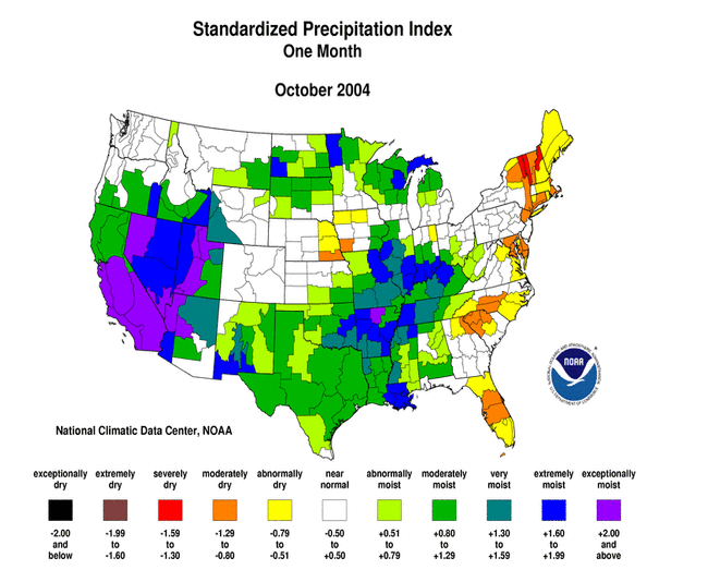
- October was dry across much of the eastern seaboard and parts of the central Plains.
- Much above-normal precipitation fell over a large part of the western U.S. drought areas, bringing drought relief (September vs. October PHDI) to the southwestern quarter of the country.
- Long-term moisture deficits (last 24 to 36 to 60 months) persisted across much of the West into the northern High Plains and central Plains.
Please Note: The data presented in this drought report are preliminary. Ranks, anomalies, and percent areas may change as more complete data are received and processed.
National Overview
On the national scale,
- severe to extreme drought affected about 6 percent of the contiguous United States as of the end of October 2004, a decrease of about 7 percent compared to last month
- about 9 percent of the contiguous U.S. fell in the moderate to extreme drought categories (based on the Palmer Drought Index) at the end of October
- on a broad scale, the last two decades were characterized by unusual wetness with short periods of extensive droughts, whereas the 1930s and 1950s were characterized by prolonged periods of extensive droughts with little wetness (see graph below right)
- about 16 percent of the contiguous U.S. fell in the severely to extremely wet categories at the end of October
- a file containing the national monthly percent area severely dry and wet from 1900 to present is available
- historical temperature, precipitation, and Palmer drought data from 1895 to present for climate divisions, states, and regions in the contiguous U.S. are available at the Climate Division: Temperature-Precipitation-Drought Data page in files having names that start with "drd964x" and ending with "txt" (without the quotes).
Regional Overview
October was dry across much of the eastern seaboard and parts of the central Plains. But widespread heavy rain and snow fell over much of the western drought areas, bringing drought relief (September vs. October PHDI) to the southwestern quarter of the country.
The October precipitation pattern at the primary stations in Alaska and Hawaii was mixed, although streamflow averaged near normal across the Hawaiian islands. The pattern in Puerto Rico was drier than normal based on Cooperative station precipitation reports, near normal based on streamflow, and mixed based on primary station precipitation reports.
Dryness persisted at the 2 month to 3 month timescales across parts of the southern Great Lakes and northern New England.

Long-term moisture deficits persisted in many areas. Much of the central and northern Rockies were dry at the 9 to 24 month timescale. Parts of the southern Rockies were dry at the 6 to 24 month timescale. Severe moisture deficits were evident at the 36 to 60 month timescale across much of the West into the northern High Plains and central Plains. These long-term hydrological drought conditions are reflected in the November 2 United States Drought Monitor map.
Some regional highlights:
- Soil moisture conditions:
- End-of-month and monthly averaged soil moisture conditions were drier than normal across parts of Wyoming and Montana, eastern Alaska, and near the surface and at depth from the central Plains to the Great Lakes, based on model computations (CPC-1, CPC-2, MRCC).
- End-of-October USDA topsoil moisture observations were dry in the Rocky Mountain states and Nebraska. These conditions were drier than the 10-year average conditions in Nebraska and Wyoming. However, the October 2004 topsoil moisture observations in all reporting states were wetter than the 5-year climatologies. This indicates that the recent precipitation has resulted in considerable improvement from the severe drought that has plagued much of the West during the last 5 to 6 years.
- Streamflow levels were below seasonal norms across parts of the West, central Plains, and Great Lakes, both as computed by models and based on USGS observations.
- Although long-term (out to 5-years) moisture conditions remained dry across much of the western U.S., drought conditions have improved in recent months. The percent area of the western U.S. (Rockies westward) experiencing moderate to extreme drought (as defined by the Palmer Drought Index) dramatically decreased during October to about 18%.
Paleoclimatic Perspective
Streamflow is a good indicator of moisture conditions for a region because it integrates across the basin the rainfall from storms, meltwater from spring snowmelt, and groundwater that feeds the streams. The level of the stream reflects hydrologic conditions, with low flows indicative of drought. On a short-term basis, daily streamflow measurements are useful for monitoring floods from heavy rainstorms, but streamflow averaged over longer time periods, such as a month or year, is more useful for monitoring drought.
Recent low flows on the Green River in Utah reflect the ongoing drought conditions in the intermountain basin and central Rockies of the western U.S. In the graph below left, the blue lines are a record of water year (October 1 to September 30) streamflow at the gage on the Green River at Green River, Utah, for the period 1906-2003. The light blue line shows annual values, while the heavy dark blue line shows the record smoothed with a 9-weight filter. This record, obtained from the USGS, has not had the effects of diversions for irrigation, reservoirs, and other factors removed, so it is not an exact reflection of natural conditions. The natural flow record is available only through 1995, but the two records are closely correlated ( r = 0.959). In the USGS gage record, water year flow has been below average since 1999. Flow values are not yet available for 2004, but estimates based on snowpack in the late spring predicted a flow of 41% of average (based on 1971-2000), so 2004 will make six years of drought, according to this streamflow record. The 2004 estimated value is marked with an "x" on the graph. Despite the severity of the current drought, the late 1980s to the early 1990s was a period of more severe and persistent low flow, with eight years of below average flow, from 1987-1994.

The water year precipitation record for southwest Wyoming, which is the headwaters of the Green River, for the period 1895-2004 is shown in the graph below right. The last 6 years (last 5 water years) have been extremely dry in this basin. The late 1980s were also very dry. The precipitation record for the Uinta Basin in northeast to east central Utah, which is where the Green River streamflow gage is located, shows a similar recent dry pattern.

The graph above left also shows a tree-ring record that corresponds well to the Green River flow record (annual values in light red, smoothed values in thick red line). The tree ring record extends from 1402-1999. This record is the average of five tree-ring chronologies that are highly correlated with the natural streamflow record for Green River. Together, they are a proxy record of past streamflow. The five chronologies are from northeastern Colorado and south central Wyoming, and tree growth at these sites is influenced by the same storms and moisture which affect Green River streamflow. The correlation between the 5-chronology average and Green River streamflow is 0.745, indicating a high degree of shared variance. The match between the two records is also visible in the graph.
If the tree-ring series is considered a long-term proxy of streamflow, an assessment of periods of persistent low flow and drought can be made over the past 600 years. The proxy record displays a wide range of variability in drought. There are short, severe episodes around 1845, 1685, and 1653. Other periods are characterized by more persistent drought, such as the 1460s and 1580s, which is a period corresponding to widespread drought conditions throughout western North America. The period of low growth/drought in the second half of the 19th century is particularly notable, and for several reasons. It appears to be the most persistent period of drought, on average, in the entire record. In addition, it is followed by a period of high growth/wet conditions in the early 20th century, the length of which appears to be unmatched in the rest of the record. The persistence of these wet conditions is also well reflected in the Green River gage record, which indicates even more extreme values.
Resources:
Water resource data, including the streamflow for the Green River at Green River, Utah shown above, can be obtained from the U.S. Geological Survey web site NWISWeb Data for the Nation:
The five tree ring chronologies used as a proxy record for Green River streamflow are from sites named Land's End, Pumphouse, Red Canyon, Trail Gulch, and Encampment. These data are available from the World Data Center for Paleoclimatology, International Tree-Ring Data Bank:
The data for the Land's End and Pumphouse chronologies can be found by using the Tree-Ring Search Engine. Red Canyon, Trail Gulch, and Encampment can be found by selecting Download Recent Tree-Ring Data, and are the files named CO583.crn, CO548.crn, and CO585.crn.