
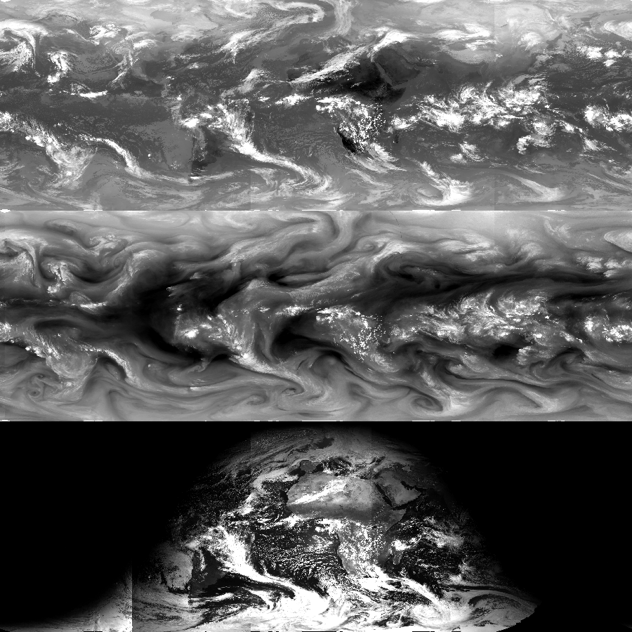
Gridded Satellite (GridSat-B1) data were created to make it easier to use geostationary data. GridSat-B1 data are gridded International Satellite Cloud Climatology Project (ISCCP) B1 data on a 0.07 degree latitude equal-angle grid. Satellites are merged by selecting the nadir-most observations for each grid point.
CDR Information
The Geostationary IR Channel Brightness Temperature (BT)- GridSat-B1 Climate Data Record (CDR) provides global BT data from geostationary Infrared (IR) satellites.
Access Methods and Usage
You can help the project receive continued support and updates by sharing information about your data usage through our optional User Registration Form. Please review the NOAA CDR Use Agreement when using GridS at-B1 data for any purpose.
Bulk File Transfer
Use the HTTPS data folder for bulk file transfers. The entire period of record is about 3 TB.
Subsets by Time and Location
The THREDDS data server can be used to download specific portions (subsets) of the data based on specific time-frames or geographic coordinates. Subsets are available in netCDF format.
Data Browsers
Use the NOAA Weather and Climate Toolkit to easily view and browse data. This tool can create maps based on time and location selection, produce images in multiple formats (PNG, GIF, JPEG, text or GIS Shapefiles), and even save movie loops.
Imagery for all GridSat-B1 CDR data are also available through the Global ISCCP B1 Browse System (GIBBS) satellite image browser.
Citation
Please cite the following article when using GridSat-B1 data in any publication:
Knapp, K. R., S. Ansari, C. L. Bain, M. A. Bourassa, M. J. Dickinson, C. Funk, C. N. Helms, C. C. Hennon, C. D. Holmes, G. J. Huffman, J. P. Kossin, H.-T. Lee, A. Loew, and G. Magnusdottir, 2011: Globally gridded satellite (GridSat) observations for climate studies. Bulletin of the American Meteorological Society, 92, 893-907. doi:10.1175/2011BAMS3039.1
Please review the NOAA CDR Use agreement when using GridSat-B1 data for any purpose.
v02r01
Last Updated
April 2014
Period of Record
January 1980–present
Update Frequency
Quarterly
Version Change Log
Changes from v01r01 to v02r01:
- Expansion of record to present
- New variables:
- irwin_vza_adj - Used to revert back to the infrared window brightness temperature prior to the view zenith angle correction.
- Raw visible data - Raw visible channel DN from the B1 data are optionally available from the PI. This can help given some issues with visible channel calibration.
- More complete metadata (numerous new global and variable attributes in netCDF files).
- Processing now creates netCDF 4 files directly (v01r01 used ncks to do the conversion).
Bug Fixes
- More thorough QC of bad images. Now ignores an image with too few scanlines and very noisy images.
- Navigation uses corrected image center.
- Corrected variable output. The problem was that some variables weren't output when a channel from one satellite was missing. This affected vschn and irwvp more often. The correction now ensures all available data are output. Correction resulted in improved coverage of irwvp and vschn, but did have a small impact on improving the irwin coverage.
- Calibration corrected if one satellite is much warmer or colder than its neighbors.
Known Issues
- CDR parameter: irwin_cdr - The infrared window channel is the only parameter having CDR quality.
- Infrared water vapor (irwvp) data is provided with some post calibration, but data gaps and some calibration issues remain. Users should inspect irwvp channel quality prior to use.
- Visible data (vschn) data are of low quality and are present solely for visualization purposes. A future version of GridSat-B1 data will have inter-calibrated vschn data
- Early data may have unreliable navigation information, which can cause alignment issues between satellite data and map overlays.
- Meteosat satellite position parameters (satrad, satlat, satlon) represent the re-projected, optimal position. This is often accurate, but for late in the life of Meteosat-5 and Meteosat-7 (both over the Indian Ocean), the sub-satellite point varied widely from the Equator. Calculation of viewing geometry during these periods will not be accurate.
Original Release: v01r01
Period of Record
January 1980–November 2010
Update Frequency
Never updated
Version Change Log
None. This was the initial release.
Known Issues
There are some lower quality geostationary images that slipped past the quality checks. The v02r01 uses enhanced tests to remove some of these.
Channels
The complete GridSat-B1 dataset provides data from 3 channels:
- CDR-quality infrared window (IRWIN) channel (near 11 μm)
- Visible channel (near 0.6 μm)
- Infrared water vapor (IRWVP) channel (near 6.7 μm)
Climate Data Record Program
The infrared window channel of GridSat-B1 is currently the only channel that meets the CDR standards for length, consistency, and continuity. The water vapor and visible channel data can still be used, but its quality has not yet been analyzed to support long-term climate analysis.
GridSat-B1 is currently at Initial Operational Capability (IOC) in the NOAA Climate Data Record Program and are updated quarterly as possible.
Dataset Description
The following tables summarize dataset variables and attributes. This overview is supplemented by the dataset attributes available in the file, which can be viewed using various tools (like ncdump). A sample ncdump of the file headers is available for Nov. 13, 1999. Information not provided below can be identified using the netCDF attributes (e.g., units of the variables).
The following table provides a summary of the variables having spatial dimensions.
| Name | Dimensions | Purpose |
|---|---|---|
| irwin_cdr | lat-lon | Primary CDR Variable. The nadir-most infrared window observation. |
| irwin_2 | lat-lon or sparse | When two satellites overlap, this layer provides the second-best observation (based on view zenith angle |
| irwin_3 | lat-lon or sparse | When three satellites overlap, this layer provides the third-best observation (based on view zenith angle. This is useful for reconstructing the entire view for a particular satellite |
| irwin_vza_adj | lat-lon | Provided to allow users to reverse the view zenith correction for the irwin_cdr variable. |
| irwvp | lat-lon | The nadir-most infrared water vapor observation. |
| irwvp_2 | lat-lon or sparse | When two satellites overlap, this layer provides the second-best observation (based on view zenith angle |
| vschn | lat-lon | The nadir-most visible channel observation. |
| vcshn_2 | lat-lon or sparse | When two satellites overlap, this layer provides the second-best observation (based on view zenith angle |
| satid_ir | lat-lon | The packed satellite index value (provides information for both the irwin_cdr and irwin_2 variables). |
| satid_ir3 | lat-lon or sparse | The satellite index for the irwin_3 variable. |
| satid_wv | lat-lon | The packed satellite index value (provides information for both the irwvp and irwvp_2 variables). |
| satid_vs | lat-lon | The packed satellite index value (provides information for both the vschn and vschn_2 variables). |
The following table provides a summary of the variables that describe the satellites used to make the observations.
| Name | Description |
|---|---|
| satlat | Latitude of the sub-satellite point at the time of observation. |
| satlon | Longitude of the sub-satellite point |
| satrad | Distance from the center of the Earth to the satellite (e.g., radius) |
| satname | Satellite name |
| b1ufile | Filename of the ISCCP B1U file corresponding to this satellite image. |
| b1file | Filename of the ISCCP B1 file corresponding to this satellite image. This is very similar to the B1U filename and is provided for completeness. |
| calslp_irwin | |
| caloff_irwin | |
| calslp_irwvp | |
| caloff_irwvp | |
| vis_rad_slope | |
| vis_dc_slope | |
| vis_dc_offset |
| Name | Purpose |
|---|---|
| sparse2ir | Values of the sparse irwin_2 array. Data are sparsely packed only when this variable has more than 2 values. |
| sparse3ir | Values of the sparse irwin_3 array. Data are sparsely packed only when this variable has more than 2 values. |
| sparse2wv | Values of the sparse irwvp_2 array. Data are sparsely packed only when this variable has more than 2 values. |
| sparse2vs | Values of the sparse vschn_2 array. Data are sparsely packed only when this variable has more than 2 values. |
Global
| Name | Description |
| references | Digital Object Identifiers (DOIs) of the peer-reviewed references describing this dataset and how it was calibrated. |
Variable
| Name | Description |
| intergeo_cal_flag | When intergeo_cal_flag=1, it means that a geostationary satellite image was deemed to have been in error based on comparisons with neighboring geostationary satellites and a correction was applied to reduce the inter-satellite brightness difference. When set to 1, the following attributes are also present: intergeo_cal_satid, intergeocal_slp, intergeo_cal_off |
Contact
Registration
You can receive updates about the dataset by telling us about your data usage and download via the optional User Registration Form. Registration is not required for data usage, but it allows us to provide relevant notifications about:
- Recent dataset updates and releases
- New dataset issues and bugs
- Suggestions for dataset improvements
Expect about 4–8 emails per year (quarterly and as conditions warrant).
Principles
The principles behind GridSat-B1 are:
- Easy data access
- Plenty of information to understand the data
- Efficient storage
Easy Data Access
The GridSat-B1 dataset was developed to simplify access to geostationary data. It removes the need for users to apply calibration to raw satellite data or navigate the native satellite projection. Instead, calibrated data are provided in an equal angle map projection (that is, an equirectangular: plate carree projection).
Data for Experts
The dataset is designed to meet the most basic user's needs: the best estimate of the geostationary data for each point. However, expert users can also modify and work with the data for different scenarios and use cases.
Nadir Correction
The infrared window channel (irwin_cdr) has been corrected using a view zentih angle correction. However, the variable irwin_vza_adj allows a user to undo previous adjustments to the data data to calculate the original brightness temperature observation.
Multiple Layers
The geostationary data often overlap, particularly in recent years. The infrared window variables provide the nadir-most observation (irwin_cdr) along with the second-most nadir observation (irwin_2) and the third-most nadir observation (irwin_3). Similarly, the primary and secondary observations are provided for water vapor (irwvp_2) and visible (vschn_2) channels.
Backing Out Satellite Digital Counts
Multiple variables are provided to back out the original satellite digital counts. For example, the digital counts for the visible channel can be estimated from the visible channels (vschn and vschn_2) using the satellite-specific calibration variables: vis_dc_slope and vis_dc_offset.
Efficient Data Storage
Data are stored in netCDF-4, which includes an option to compress variables internally to save space.
Primary variables (irwin_cdr, irwvp, vschn) are always stored as 2-dimensional variables. However, secondary (e.g., irwin_2) and tertiary (e.g., irwin_3) views can be either stored as 2-D or sparse arrays, whichever is more efficient. Sparse arrays are CF-compliant and described in CF as compression by gathering.
Viewing and solar geometry are not provided explicitly. Solar angles (zenith and azimuth) can be computed directly from the time of observation and the gridcell latitude/longitude. Satellite view angles (zenith and azimuth) can be computed from the satellite position and the gridcell position. Satellite-specific positions are provided (satrad, satlon, and satlat) for these calculations.
Note: Pink courier font denotes netCDF variable names in the GridSat-B1 files.
Frequently Asked Questions
The Frequently Asked Questions PDF provides answers to many of the questions we receive about GridSat-B1 data. For more information, please contact us at gridsat_b1_contacts@noaa.gov.
Related Projects
- HURSAT-B1 shares source data (ISCCP B1) and processing code (including data quality and calibration) with GridSat-B1
- ISCCP B1 is the source of this dataset
- netCDF Climate and Forecasting (CF) convention
- Software for reading netCDF files
Using Information In NetCDF Files
Calculating Brightness Temperatures
NetCDF values are stored as integers and can be converted to floats following the CF convention and the variables attributes:
Value = Integer * scale_factor + add_offset
Many of the available netCDF access tools perform this adjustment automatically. More information on data storage is provided in documentation of the netCDF Climate and Forecasting (CF) convention.
Removing the View Zenith Angle Correction
The infrared window channel data have a view zenith angle correction applied, which was defined by Joyce et. al (2001). However, users have the ability to remove this correction. The variable irwin_vza_adj contains the level of correction. As documented in the attributes, the variable can be used to un-correct the irwin_cdr data via:
Original_temperature_observed = variable(irwin_cdr) - variable(irwin_vza_adj)
Note: Users need to convert the irwin_cdr (stored as short) and irwin_vza_adj (stored as byte) to floats using the scale_factor and add_offsets prior to applying the above equation.
Joyce, R., J. Janowiak, and G. Huffman, 2001: Latitudinally and Seasonally Dependent Zenith-Angle Corrections for Geostationary Satellite IR Brightness Temperatures. Journal of Applied Meteorology, 40, 689-703.
Calculating Solar and Satellite Angles
The solar and satellite angles (zenith and azimuth) are not stored in GridSat-B1 since they can be calculated directly from the data provided in the file. An appendix from the GridSat-B1 C-ATBD provides information on how these parameters can be calculated.
Identifying the Satellite that Observed Each Pixel
Each pixel derives from a specific satellite. That satellite is identified by the satid_* variables in the netCDF file. The method to determine the source satellite for each pixel is described in: using_satid.pdf
Mapping the Sparse Array Data
Data for secondary and tertiary views (or layers) can be stored as sparse arrays. The CF convention for this compression technique is called compression by gathering.


