North Atlantic
A more in-depth analysis of the 2015 North Atlantic and East Pacific Hurricane Season will be available in January 2016.
November marks a continuation of a record-long streak with no major hurricanes (Category 3 or stronger) making landfall in the United States. The last major hurricane to make landfall in the U.S. was Wilma on November 24, 2005. This major hurricane drought surpassed the length of the eight-years from 1861-1868 when no major hurricane struck the United States' coast. On average, a major hurricane makes landfall in the U.S. about once every three years. The reliable record of landfalling hurricanes in the U.S. dates back to 1851.
| Storm Type | November 2015 | November 1981-2010 Average | Record Most for November Period of Record: 1851-2015 |
|---|---|---|---|
| Tropical Storm (Winds > 39 mph) |
1 | 0.7 | 3 (2001, 2005) |
| Hurricane (Winds > 74 mph) |
1 | 0.5 |
3 (2001) |
| Major Hurricane (Winds > 111 mph) |
0 | 0.1 | 1 (1912, 1932, 1956, 1985, 1999, 2001, 2008) |
| Name | Dates of winds >39 mph |
Maximum Sustained Winds |
Minimum Central Pressure |
Landfall |
|---|---|---|---|---|
| Hurricane Kate (Cat. 1) | November 9th - 12th | 75 | 983 | Remnants impacted Western Europe |
East Pacific
| Storm Type | November 2015 | November 1981-2010 Average | Record Most for November Period of Record: 1949-2015 |
|---|---|---|---|
| Tropical Storm (Winds >39 mph) |
2 | 0.3 | 2 (1961, 1972, 2006) |
| Hurricane (Winds >74 mph) |
1 | 0.2 |
3 (1957, 1983, 1985, 1998, 2003) |
| Major Hurricane (Winds >111 mph) |
1 | 0.0 | 1 (2011, 2015) |
| Name | Dates of winds >39 mph |
Maximum Sustained Winds |
Minimum Central Pressure |
Landfall |
|---|---|---|---|---|
| Tropical Storm Rick | November 18th-22nd | 40 mph | 1002 mb | N/A |
| Hurricane Sandra (Cat. 4) | November 23rd-28th | 145 mph | 935 mb | N/A - Impacts felt in the Baja Peninsula |
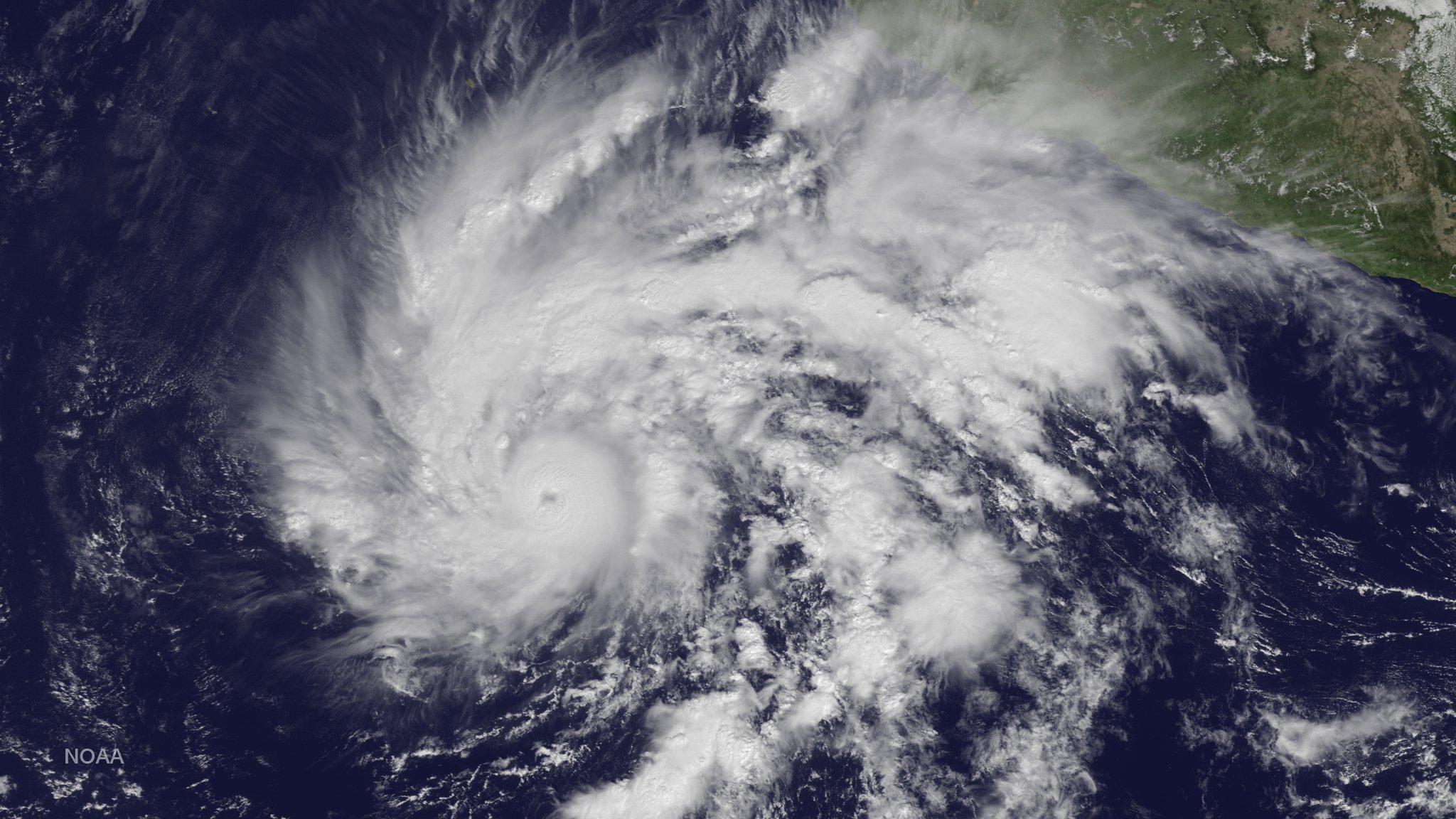
Hurricane Sandra formed from a low pressure system off the west coast of Mexico on November 23rd, reaching hurricane strength on the 24th as the system drifted to the northeast. Warm sea surface temperatures and low wind shear created ideal conditions for the hurricane to rapidly intensify, with the storm reaching Category 3 strength (major hurricane) on the 25th. Sandra marked the 11th major hurricane observed in the basin during 2015. Sandra's intensity peaked on November 26th with winds of 145 mph and a central minimum pressure of 935 mb, a Category 4 strength hurricane. Over the next four days, strong wind shear caused Sandra to rapidly weaken before reaching the Mexican coast, where only minimum impacts were experienced. By the 28th, Sandra was only a remnant low. The strength of Sandra was unusual due to how late in the season the storm occurred. Sandra was the latest major hurricane, and Category 4 hurricane, observed in the Western Hemisphere (East Pacific and North Atlantic basins) on record. Sandra's central minimum pressure was the lowest ever observed in the East Pacific during the month of November, and the wind speed tied 2011's Hurricane Kenneth as the strongest November hurricane in the basin. Sandra was also the 25th Category 4 or stronger tropical cyclone observed in the Northern Hemisphere during 2015, surpassing the previous record of 18 observed in 1997 and 2004.