Atlantic Basin
2009 Season Summary:
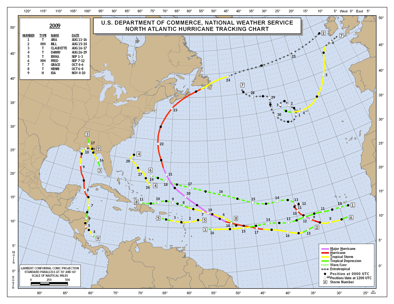
The 2009 North Atlantic hurricane season had nine named storms, three hurricanes, and two major hurricanes. This is the fewest number of hurricanes for a North Atlantic season since 1997. An average season has 11 named storms, six hurricanes, and two major hurricanes. Only two tropical storms and no hurricanes made landfall in the U.S. for the season. This is only the 13th time that no hurricanes have struck the U.S. during a hurricane season (June-November) since 1943.
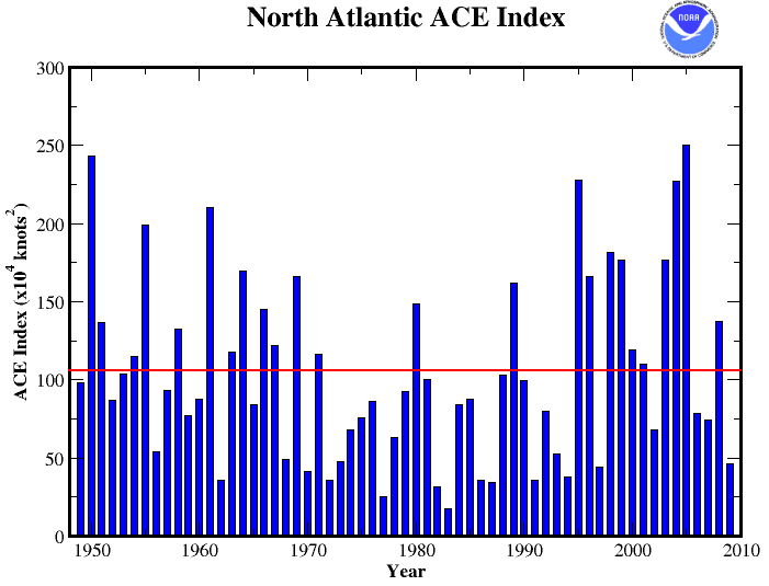
The ACE index of hurricane activity also indicated a below-average season, with a preliminary value of approximately 46x104 knots2. The 1949-2008 ACE average is 106x104 knots2, with 2009 having the 12th lowest ACE since 1949. The below average conditions are attributable to higher than average wind shear and lower than average relative humidity in the middle atmosphere suppressing tropical cyclone development across the basin. These conditions are expected during an El Niño, similar to the one that developed over the course of the 2009 hurricane season. Of the 11 seasons with a lower ACE index, nine occurred during El Niño events.
The 2009 season got off to a late start with Ana forming on August 15th; this is the latest date for the first named tropical storm in the Atlantic since Hurricane Andrew formed on August 17th, 1992.
Hurricane Bill became the strongest tropical cyclone of the Atlantic season with sustained winds of 135 mph (217 km/hr) and a central minimum pressure of 943 mb. Bill was also a very large storm with tropical storm force winds extending 230 miles (370 km) from the storm's center. This is the fifth largest diameter of tropical storm force winds on record for the basin. Bill made landfall along Newfoundland, Canada as a tropical storm on August 24th.
Hurricane Ida was the most destructive storm of the 2009 hurricane season contributing to hundreds of deaths in El Salvador, Honduras, and Nicaragua. Ida is also notable because it was the first November hurricane to make landfall during an El Niño event since 1925. Ida intensified rapidly off the Nicaragua coast to a Category 1 hurricane on November 4th in less than 24 hours after the first National Hurricane Center advisory was issued. This is the second fastest hurricane intensification on record, behind Humberto in 1970 which intensified to hurricane status in less than 18 hours. Ida emerged into the Caribbean and strengthened to a Category 2 hurricane on November 8th. Ida eventually weakened and made a second landfall as a tropical storm near Dauphin Island, Alabama on November 10th making Ida the second latest tropical cyclone to make landfall along the Gulf Coast, trailing only Hurricane Kate in 1985 which made landfall on November 21st
Pacific Basin
2009 Season Summary:

The 2009 Eastern Pacific hurricane season had 17 named storms, seven hurricanes, and four major hurricanes. An average season experiences 16 named storms, nine hurricanes, and four major hurricanes, putting the 2009 season near normal. For the first time in 10 years, no tropical depressions formed during the month of May. The first named storm of the season, Hurricane Andres, did not develop until June 21st, marking the latest start to a Pacific hurricane season in 40 years. The basin made up for a late start with the most active August since 1968, with eight named storms.
The developing El Niño produced conditions which are more favorable for tropical cyclone development in the Eastern Pacific basin. A developing El Niño often leads to decreased wind shear across the basin. The only two seasons with above-normal number of storms since 1995 have been years with an El Niño event.
The ACE index of hurricane activity in the basin had a preliminary value of approximately 106x104 knots2. The 1970-2008 ACE average is 132x104 knots2. In terms of energy, this places the 2009 season in the near-normal category.
Hurricane Jimena formed off the western Mexican coast on August 29th and strengthened to a Category 4 storm on August 31st with maximum sustained winds of 155 mph (250 km/hr) and a minimum central pressure of 931 mb. Jimena weakened and made landfall as a Category 2 on September 2nd near Cabo San Lazaro. At least three deaths are blamed on Jimena in Mexico.
Hurricane Rick formed on October 15th. On October 17th Rick strengthened to a Category 5 storm with maximum sustained winds of 180 mph (285 hm/hr) and a minimum central pressure of 906 mb. Rick was the first Category 5 storm in the basin since Hurricane Kenna in 2002. Rick was also the second strongest hurricane ever recorded for the basin, behind Hurricane Linda in 1997, and the strongest October hurricane for the basin. Rick’s impressive strength was not long lived as it weakened to a tropical storm on the 20th, and made land-fall on the 21st near Mazatlan, Mexico with 55 mph (90 km/hr) winds.