Note: This Synoptic Discussion describes recent weather events and climate anomalies in relation to the phenomena that cause the weather. These phenomena include the jet stream, fronts and low pressure systems that bring precipitation, high pressure systems that bring dry weather, and the mechanisms which control these features — such as El Niño, La Niña, and other oceanic and atmospheric drivers (PNA, NAO, AO, and others). The report may contain more technical language than other components of the State of the Climate series.
Synoptic Discussion
The 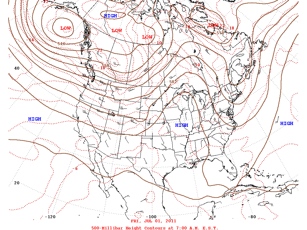 weather pattern over the contiguous United States during July 2011 was dominated by a large and persistent upper-level high pressure ridge which brought hot and mostly dry weather to the southern and eastern regions, worsening drought conditions. An upper-level low pressure trough brought cooler-than-normal weather over the Northwest, with the storm track mostly keeping to the northern states and southern Canada. Weak cold fronts occasionally collided with the upper high but weakened further and dissipated as they moved further south.
More than 2750 daily high temperature records were tied or broken in July 2011, and there were 143 reports of the record hottest temperature for July and 78 reports of all-time record hottest temperature ever. Nighttime temperatures were also warm, with over 6100 reports of record daily warm minimum temperatures.
Texas, Oklahoma, and Delaware had the hottest July in the 1895-2011 record while 25 other states, from the southern Rockies to the Atlantic coast, ranked in the top ten warmest category. In contrast, Washington and Oregon, which were beneath the upper trough, had the 11th and 13th, respectively, coolest July on record. The persistence of this weather pattern (trough northwest and ridge over the south and east) during the last three months has resulted in record extremes: Washington had the coolest May-July in the 1895-2011 record while Oklahoma ranked warmest.
July 2011 was the second driest July for Texas and ninth driest for Oklahoma, and below-normal precipitation was widespread from the Southern and Central Plains to the East Coast. In spite of the hot and dry weather, wildfire activity during July was below average. Seasonal monsoon showers over the Southwest brought the July precipitation rank for New Mexico up to 32nd driest, but parched conditions earlier in the year resulted in the driest year-to-date (January-July) for New Mexico as well as Texas, and second driest for Oklahoma and Louisiana. In contrast, the year-to-date has been much wetter than normal for the northern tier states and Ohio Valley. The hot and dry July weather expanded drought in the South to Northeast and intensified the record drought in the Southern Plains. While earlier droughts are unsurpassed in terms of duration, the current drought in parts of the Southern Plains is more intense when measured by the Palmer Hydrological Drought Index. Nationally, the size of the drought footprint (moderate to exceptional drought as measured by the U.S. Drought Monitor) grew from 28 percent to 32 percent. The largest national footprint of D4 ("exceptional" drought) in the 12-year history of the U.S. Drought Monitor occurred in July.
While blanketing the southern U.S. with hot and dry weather, the upper High effectively blocked the Gulf of Mexico moisture from feeding severe storms, resulting in only 88 preliminary tornado reports during July, which is below the national average for the month. It also helped deflect tropical systems away from the U.S., with Tropical Storm Don barely brushing southern Texas before weakening at the end of the month.
Flooding along the Missouri River continued in July due to above-normal summer rainfall and lingering meltwater from a heavy spring and early summer snowpack. The persistence of the precipitation patterns over the last several months created a notable imprint on the nation's soil moisture, with excessively wet soils in the north and extremely dry soils in the south. This soil moisture pattern is international — with the dry end extending into Mexico while the wet end extended into the southern Canadian Prairies with the northern Prairies dry.
When averaged together, the mixture of temperature and precipitation extremes gave the U.S. the fourth warmest and 20th driest July in the 117-year record. Averaging extremes tends to cancel them out. But when extremes are combined cumulatively, like in the U.S. Climate Extremes Index (CEI), they tell a different story. The large increase in hot temperatures and total area in very wet or very dry conditions over the last three months combined to produce a May-July 2011 national CEI of 40 percent, which is twice the value it would have in a "normal" year. The May-July 2011 CEI ranks as the third largest May-July CEI in the 1910-2011 record, behind May-July 1934 (largest) and May-July 1915 (second largest). The South region's May-July 2011 CEI was the highest May-July CEI on record, resulting from an unusual preponderance of hot daytime high temperatures, very warm nighttime low temperatures, expansive drought, and lack of days with rain. On a monthly basis, the July 2011 CEI was a record July value for the nation and the South, with the Southeast having the second most extreme July CEI.
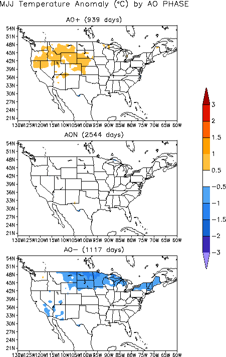
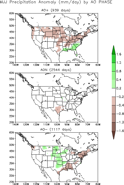
Cold fronts and low pressure systems moving in the storm track flow are influenced by the broadscale atmospheric circulation. Two such large-scale atmospheric circulation drivers were essentially neutral during July. The equatorial Pacific was in an ENSO-neutral state, with the La Niña officially over even though atmospheric circulation anomalies still reflected some aspects of La Niña. The Pacific/North American (PNA) pattern was also neutral and thus not a significant player in the nation's weather this month. But two other large-scale atmospheric circulation drivers were influential during July 2011. The first was the North Atlantic Oscillation (NAO) pattern, which was slightly negative for most of the month. A negative NAO this time of year (summer, represented by July on the NAO teleconnection maps) is typically associated with warmer-than-normal temperatures and drier-than-normal conditions in the Southern Plains and Southeast, cooler-than-normal weather in the Northwest and Northern Plains, and wetter-than-normal conditions in the Northern Plains and Midwest. The second atmospheric circulation index was the Arctic Oscillation (AO) pattern, which was negative the first half of the month and neutral the second half. A negative AO this time of year (May-July) is typically associated with coolness in the Northern Plains and Great Lakes to Northeast, dryness in the Southeast to Northeast, and anomalous wetness in the Northern to Central Plains.
The pattern of observed temperature anomalies for July 2011 and the last three months (May-July) is a very good match for the NAO pattern for July (summer). The July 2011 and May-July 2011 precipitation patterns are a reasonable match for the NAO and AO patterns in the Southern Plains and Southeast to Northeast.