Monthly Report Summary Information
The Monthly Report Summary Information is a synopsis of the collection of national and global summaries released each month.
National Summary Information - July 2016
See Full Report
For extended analysis of regional temperature and precipitation patterns,as well as extreme events, please see our full report that will be released on August 11th.

Significant climate events for July 2016
July was warmer than average, year to date 3rd warmest for U.S.
Record heat hits parts of southern/eastern U.S. and Alaska
The July temperature for the contiguous U.S. was 75.3°F, or 1.6°F above the 20th century average, ranking as the 14th warmest on record. The year-to-date (January-July) temperature was 54.3°F, 3.0°F above the 20th century average, making it the third warmest on record. Alaska continued to be record warm for the first seven months of 2016.
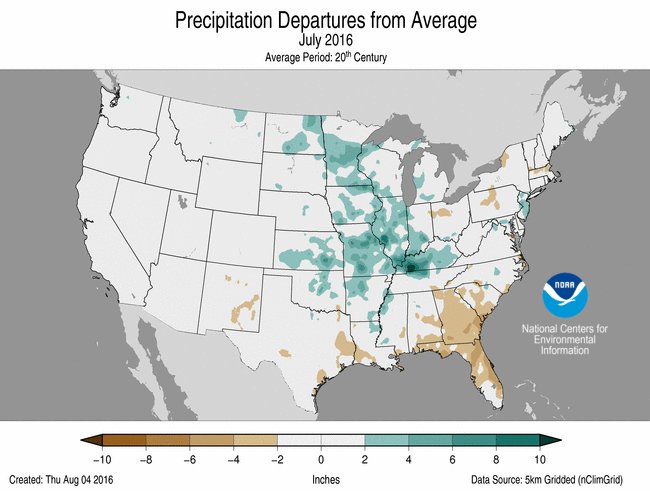
The July precipitation total for the contiguous U.S. was 2.87 inches, 0.09 inch above the 20th century average, and ranked near the middle value in the 122-year period of record. Record rainfall across western Kentucky caused widespread flooding. Tropical Storm Darby swept across Hawaii in late July causing flooding, but helped to alleviate drought conditions. The year-to-date precipitation total for the contiguous U.S. was 18.49 inches, 0.40 inch above average, and ranked near the middle value in the 122-year period of record.
This analysis of U.S. temperature and precipitation is based on data back to January 1895, resulting in 122 years of data.
U.S. climate highlights: July
Temperature

July 2016 Temperature Departure from Average
(top) and Precipitation Percent of Average (bottom)
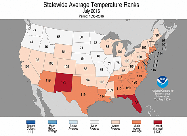
- Above-average temperatures were widespread across the southern half of the nation and along the East Coast. Eighteen states, including Alaska, had July temperatures that were much above average. Florida and New Mexico had their warmest July on record.
- The New Mexico statewide average temperature was 76.8°F, 4.1°F above average, tying July 2003 as the warmest month for the state.
- The Florida statewide average temperature was 84.0°F, 3.0°F above average, and was the second warmest month in the 122-year period of record, behind only Jule 1998.
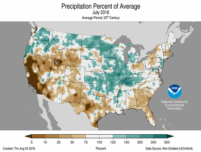
Precipitation
- Above-average precipitation was widespread across the Northwest, Northern and Central Plains, and Midwest. Illinois, Kentucky, Minnesota, Missouri and North Dakota each had July precipitation totals that were much above average. Parts of western Kentucky were record wet where heavy rainfall caused widespread flooding.
- Below-average precipitation was observed across the Southwest, Central Rockies, Southern Plains and along parts of the East Coast. Florida, Georgia, New Mexico and Wyoming each had much below average July precipitation. In the Northeast, continued dry conditions contributed to expanding drought.
- On July 24, Tropical Storm Darby made landfall on Hawaii's Big Island with sustained winds of 40 mph. The storm moved to the northwest, skirting southern parts of the state. Heavy rains from Darby caused flooding with precipitation totals exceeding 10 inches in some locations. Darby is only the fifth tropical storm or hurricane to make landfall in Hawaii since records began in 1949.
- According to the August 2 U.S. Drought Monitor report, 21.1 percent of the contiguous U.S. was in drought, up about 4.9 percent compared to the end of Jule. Drought conditions worsened and expanded across parts of the Southeast, Great Plains and Northeast. Drought reduction was observed across parts of the Upper Midwest and the Hawaiian Islands. Drought and wildfires continued to plague California.
U.S. climate highlights: year-to-date (January-July)
Temperature
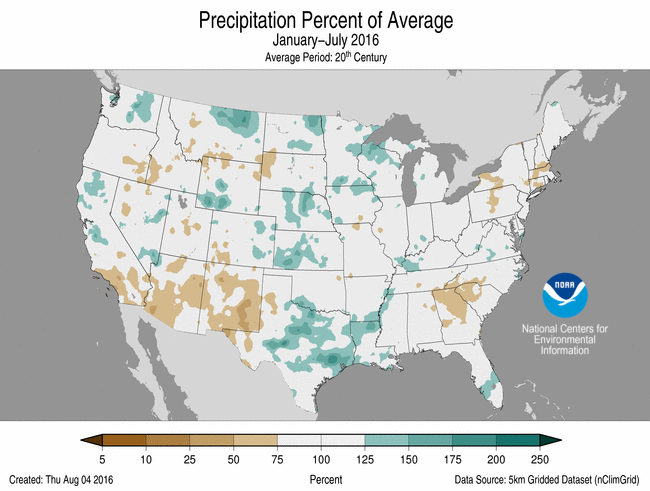
Jan-Jul Temperature Departure from Average
(top) and Precipitation Percent of Average (bottom)
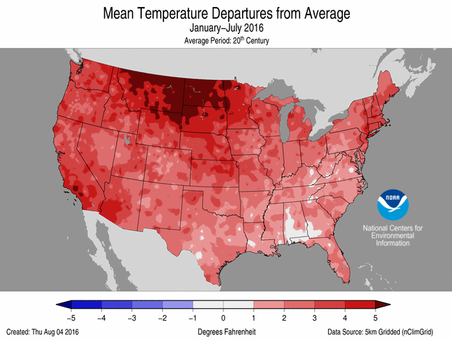
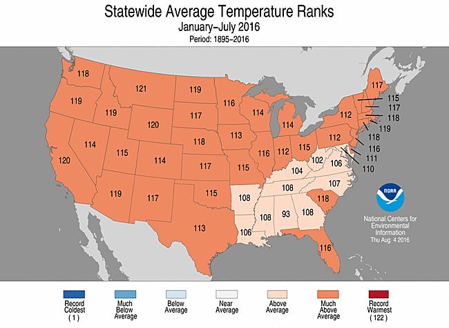
- Above-average temperatures spanned the nation for the first seven months of 2016, with every state being warmer than average. Overall, the contiguous U.S. was the third warmest on record. Thirty-eight states across the West, including Alaska, the Great Plains, Midwest and Northeast were much warmer than average, while parts of the Southeast observed above-average temperatures. No state in the contiguous U.S. was record warm.
- Alaska was record warm for the year-to-date with a statewide temperature of 33.9°F, 8.1°F above the 1925-2000 average. This bested the previous record of 31.2°F set in 1981.
Precipitation
- Year-to-date precipitation totals across the contiguous U.S. were mixed. Above-average precipitation was observed for parts of the Northwest, Great Plains, Midwest and Mid-Atlantic. Below-average precipitation fell across parts of the Southwest, Southeast and Northeast. No state was record dry or wet for the seven-month period, but Connecticut had its seventh driest year-to-date and Massachusetts its ninth driest.
Extremes
- The U.S. Climate Extremes Index (USCEI) for the year-to-date was 60 percent above average and the eighth highest value on record. On the national scale, extremes in warm maximum and minimum temperatures, the spatial extent of wetness and one-day precipitation totals were much above average. The USCEI is an index that tracks extremes (falling in the upper or lower 10 percent of the record) in land-falling tropical cyclones, temperature, precipitation and drought across the contiguous U.S.
For extended analysis of regional temperature and precipitation patterns, as well as extreme events, please see our full report that will be released on August 11th.