Summary Information
The Monthly Report Summary Information is a synopsis of the collection of national and global summaries released each month.
« National Summary Information 2016Full Report »
National Summary Information for March 2016
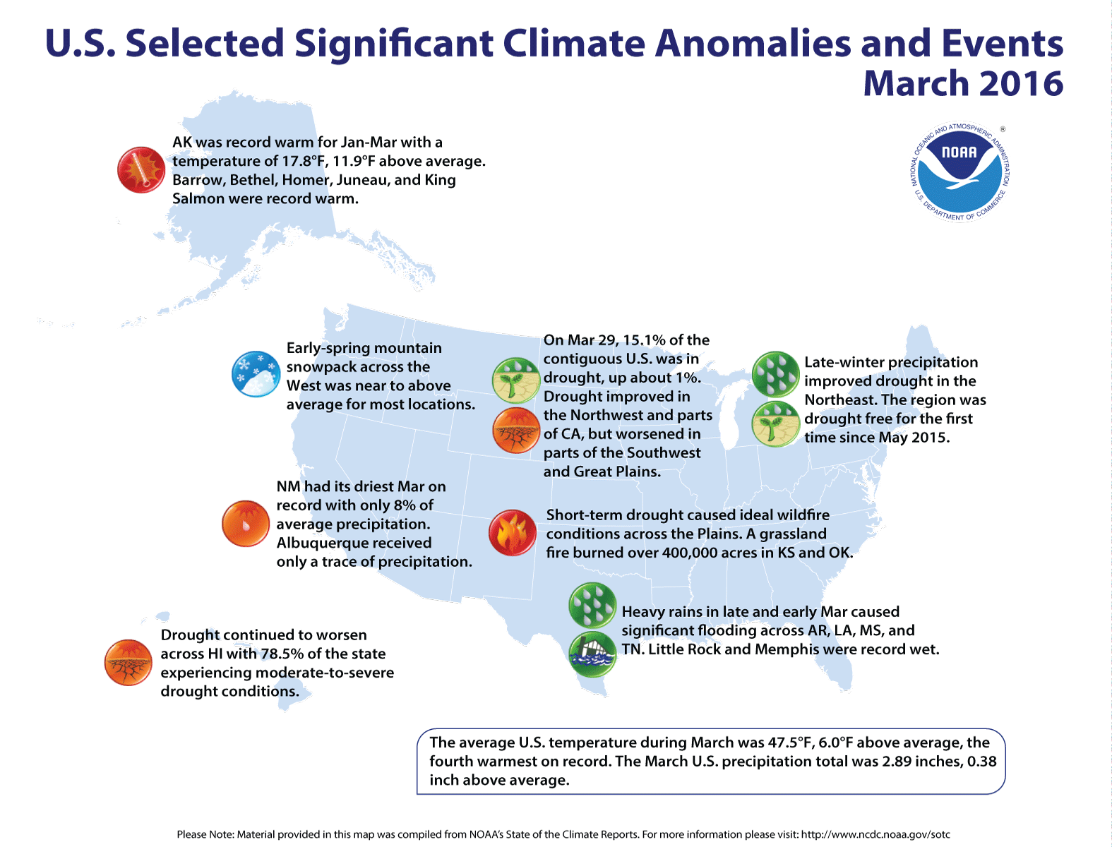
Significant climate events for March 2016
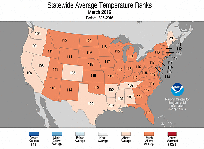
March was 4th warmest for contiguous US
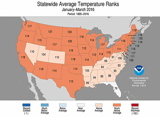
Lower 48 states had 3rd warmest year to date, and Alaska was record warm
The March temperature for the contiguous U.S. was 47.5°F, or 6.0°F above the 20th century average, the warmest since 2012. The January-March temperature was 39.7°F, 4.6°F above the 20th century average, also the warmest since 2012. The March precipitation total for the contiguous U.S. was 2.89 inches, 0.38 inch above the 20th century average. The January-March precipitation total was 6.92 inches, 0.04 inch below average.
This analysis of U.S. temperature and precipitation is based on data back to January 1895, resulting in 122 years of data.
Supplemental March 2016 Information
U.S. climate highlights: March
Temperature
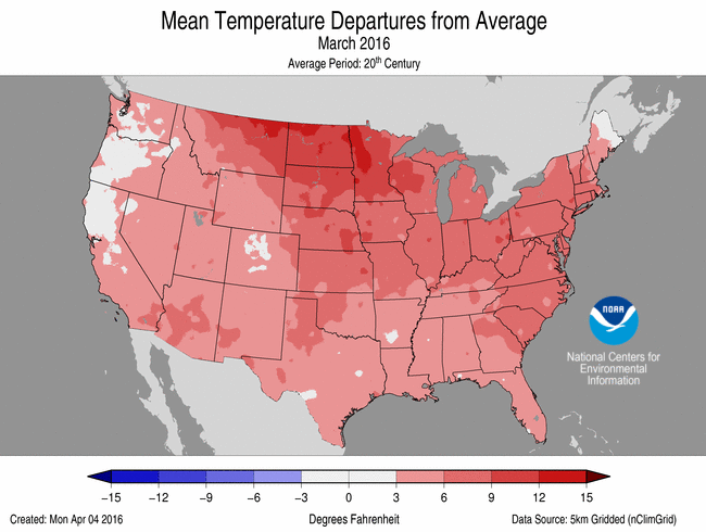
March 2016 Temperature Departure from Average
(top) and Precipitation Percent of Average (bottom)
- Every state in the contiguous U.S. had an above-average March temperature. Temperatures were much warmer than average across parts of the Rocky Mountains, Central and Northern Plains, Midwest, and along the East Coast. No state had a record warm March.
- The Alaska March temperature was the sixth warmest on record at 18.6°F, 7.8°F above average. Record warmth was observed across southern parts of the state. The end of March was particularly warm for Alaska with several locations setting new March daily temperature records. On March 31, the temperature at Klawock in southeastern Alaska reached 71.0°F, the warmest March temperature ever observed in the state.
Precipitation
- Above-average precipitation was observed along the West Coast, Midwest, Southern Plains and Lower Mississippi River Valley. Seven states were much wetter than average. Record-breaking rain events at both the beginning and end of March caused significant flooding across parts of the Lower Mississippi River Valley. Memphis, Tennessee and Little Rock, Arkansas, each had their wettest March on record with 16.20 inches and 12.33 inches of rain, respectively.
- Below-average precipitation was observed across parts of the Southwest and Central Plains and along parts of the East Coast, where eight states were much drier than average. New Mexico had its driest March on record with 0.06 inch of precipitation, only 8 percent of average.
- According to the March 29 U.S. Drought Monitor report, 15.1 percent of the contiguous U.S. was in drought, up about 0.8 percent compared to the beginning of March. Drought conditions improved across parts of the Northwest and Northern California, however, drought conditions continued to impact over 90 percent of California. Drought conditions worsened in the Southwest and parts of the Southern and Central Plains. Short-term drought created ideal wildfire conditions along the Oklahoma and Kansas border, where a grassland fire charred more than 400,000 acres, the largest wildfire on record in Kansas.
U.S. climate highlights: year-to-date (January-March)
Temperature
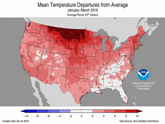

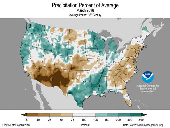
Jan-Mar Temperature Departure from Average
(top) and Precipitation Percent of Average (bottom)
- Above-average temperatures spanned the nation for the first three months of 2016. Thirty-two states across the West, Great Plains, Midwest and Northeast were much warmer than average. Florida had a near-average January-March temperature.
- Alaska was record warm for the year-to-date with a statewide temperature of 17.8°F, 11.9°F above average. This bested the previous record of 17.0°F in 1981. Record warmth was observed across large areas of the state with several locations being record warm including: Barrow, Bethel, Homer, Juneau and King Salmon.
Precipitation
- Above-average precipitation was observed for parts of the Northwest, Northern Rockies, Midwest and Southeast. Michigan and Wisconsin had a much wetter than average year-to-date. Below-average precipitation was observed across parts of the Southwest, Northern Rockies and Central Plains and along parts of the East Coast. New Mexico had its 11th driest year-to-date.
Extremes
- The U.S. Climate Extremes Index (USCEI) for the year-to-date was 45 percent above average and the 13th highest value on record. On the national scale, extremes in warm maximum and minimum temperatures and the spatial extent of wetness were much above average. The USCEI is an index that tracks extremes (falling in the upper or lower 10 percent of the record) in temperature, precipitation and drought across the contiguous United States
For extended analysis of regional temperature and precipitation patterns, as well as extreme events, please see our full report that will be released on April 11th.