Summary Information
The Monthly Report Summary Information is a synopsis of the collection of national and global summaries released each month.
« National Summary Information 2016Full Report »
National Summary Information for February 2016

Significant climate events for February 2016
Winter was record warm for the contiguous US
Alaska experiences 2nd warmest winter on record
The strong El Niño that was present in the Equatorial Pacific interacted with other climate patterns to influence U.S. weather conditions during winter and February.
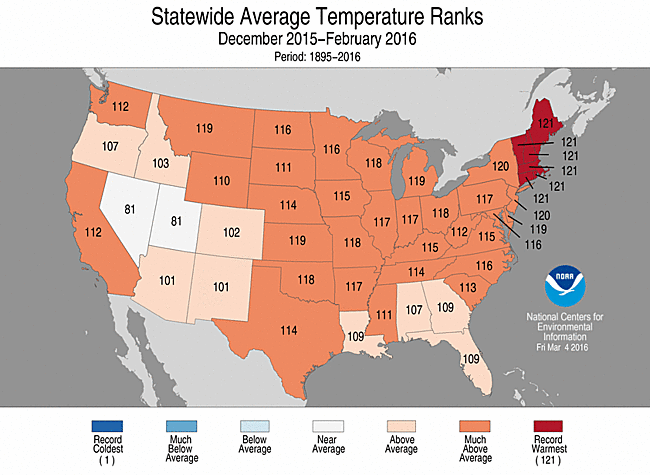
The December-February average temperature for the contiguous U.S. was 36.8°F, 4.6°F above the 20th century average, surpassing the previous record of 36.5°F set in 1999/2000. The exceptionally warm December boosted the contiguous U.S. winter temperature. The February temperature for the contiguous U.S. was 39.5°F, 5.7°F above the 20th century average, ranking as the seventh warmest on record and warmest since 2000.
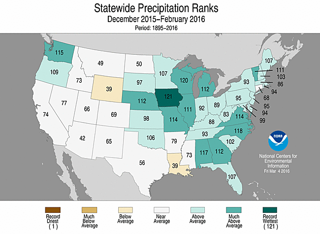
The winter precipitation total for the contiguous U.S. was 8.05 inches, 1.26 inches above the 20th century average. This was the 12th wettest December-February on record for the Lower 48 and the wettest since 1997/1998. The February precipitation total was 1.93 inches, 0.20 inch below average, and ranked near the median value in the 122-year period of record.
This analysis of U.S. temperature and precipitation is based on data back to January 1895, resulting in 122 years of data.
Supplemental February 2016 Information
- December-February station temperature anomalies
- December-February station precipitation anomalies
- Warmest winters for the contiguous U.S.
- Regional warmest winters
- Winter snowfall totals
- Alaska Divisional Temperature and Precipiation Maps
U.S. climate highlights: winter (December 2015-February 2016)
Temperature
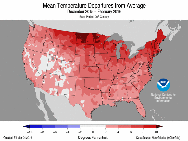
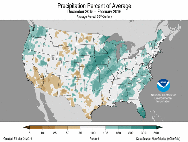
Dec 2015-Feb 2016 Temperature Departure from Average
(top) and Precipitation Percent of Average (bottom)
- Forty-six states across the contiguous U.S. had a winter temperature that was above average. Much-above average winter temperatures were observed across the West, Great Plains, Midwest, Southeast, and Northeast. Each of the six New England states had a winter temperature that was record warm.
- Alaska had its second warmest December-February with a statewide temperature of 14.2°F, 10.6°F above average. Several locations across Alaska were record warm including Barrow and King Salmon, while Anchorage and Juneau had their second warmest December-February.
Precipitation
- Above-average winter precipitation was observed across the Northwest, Central Plains, Midwest, and along the East Coast. Twelve states had winter precipitation totals that were much above average. Iowa was record wet with 6.20 inches of precipitation, 3.07 inches above average, surpassing the previous record of 5.79 inches in 1914/1915.
- Hawaii had a dry winter with nearly all locations across the islands observing below average precipitation. Honolulu received 0.70 inch of rain from December to February, only 9 percent of normal and 0.20 inch below the previous record in 1976/1977.
Extremes
- The U.S. Climate Extremes Index (USCEI) for winter was 20 percent above average and the 27th highest value on record. On the national scale, extremes in one-day precipitation totals and the spatial extent of wetness were much above average. The USCEI is an index that tracks extremes (falling in the upper or lower 10 percent of the record) in temperature, precipitation, land-falling tropical cyclones, and drought across the contiguous U.S.
U.S. climate highlights: February
Temperature
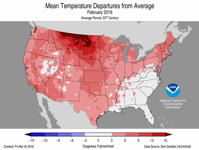
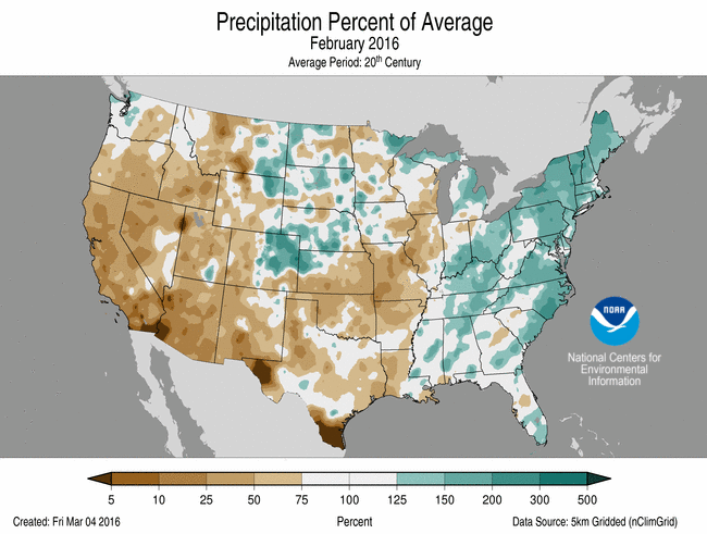
February 2016 Temperature Departure from Average
(top) and Precipitation Percent of Average (bottom)
- Above-average February temperatures were widespread across the western half of the nation as well as parts of the Midwest and Northeast, where 21 states were much warmer than average. Alaska had its warmest February on record with a statewide temperature of 17.2°F, 12.4°F above average. Near-average February temperatures were observed across the Southeast.
Precipitation
- Below-average February precipitation was observed across the western half of the Lower 48, including the drought-stricken areas of California. Above-average February precipitation was observed across the East. Four states in the Northeast had a February precipitation total that was much above average.
- According to the March 1 U.S. Drought Monitor report, 14.3 percent of the contiguous U.S. was in drought, down about 1.2 percent compared to the beginning of February. Drought conditions improved across parts of the Northwest and Northeast, with drought worsening in parts of the Southern Plains and Southwest. Over 95 percent of California continued experiencing drought conditions, with 38 percent of the state remaining in the worst category of drought.
- Outside of the contiguous U.S., the dry winter in Hawaii caused drought conditions to expand to over half of the state. Several months of drought across the U.S.-affiliated Pacific Islands led to a state of emergency in the Marshall Islands and the Federated States of Micronesia. Drought conditions improved across eastern Puerto Rico.
For extended analysis of regional temperature and precipitation patterns, as well as extreme events, please see our full report that will be released on March 10th.