Monthly Report Summary Information
The Monthly Report Summary Information is a synopsis of the collection of national and global summaries released each month.
National Summary Information - January 2016
See Full Report
For extended analysis of regional temperature and precipitation patterns,as well as extreme events, please see our full report that will be released on February 10th.

Significant climate events for January 2016
January was warmer, drier than average for contiguous US
A record-breaking snow storm impacted the Mid-Atlantic and Northeast. The contiguous U.S. drought footprint contracted to lowest extent since 2010.
The January contiguous U.S. average temperature was 32.2°F, 2.1°F above the 20th century average, ranking as the 34th warmest January on record. The January precipitation total for the contiguous U.S. was 2.03 inches, 0.28 inch below the 20th century average, the 36th driest January on record. Precipitation in the West slightly improved long-term drought conditions.
This analysis of U.S. temperature and precipitation is based on data back to January 1895, resulting in 122 years of data.
U.S. climate highlights: January
Temperature
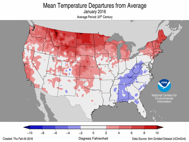
January 2016 Temperature Departure from Average
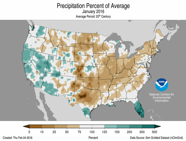
(top) and Precipitation Percent of Average (bottom)
- Above-average temperatures were observed across the West, Northern and Central Plains, Upper Midwest, and the Northeast. Maine observed its 11th warmest January on record. Below-average temperatures occurred in the Mid-Atlantic and Southeast.
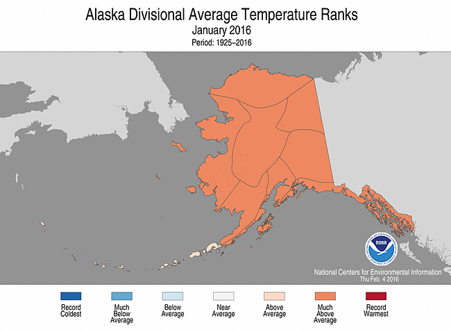
- Alaska had its fifth warmest January on record. The statewide average temperature of 17.1°F was 15.0°F above the long-term average. Much-above-average temperatures were observed throughout the state, with slightly above-average temperatures across the Aleutians.
Precipitation
- Below-average precipitation was observed across much of the eastern United States. Ohio had its ninth driest January with a precipitation total of 1.28 inches of precipitation, 1.53 inches below average.
- Above-average precipitation fell across parts of the West and in Florida. Parts of Florida were record wet and the statewide precipitation total of 5.96 inches was 3.00 inches above average and ranked as the fourth wettest January for the state.
- According to an analysis of NOAA data by the Rutgers Global Snow Lab, the January contiguous U.S. snow cover extent was 1.65 million square miles, 286,000 square miles above the 1981-2010 average, and the seventh largest in the 50-year period of record. Above-average snow cover was observed across the West, Northern Plains, and Northeast, with below-average snow cover in parts of the Southern Plains.
- According to the February 2nd U.S. Drought Monitor report, 15.5 percent of the contiguous U.S. was in drought, down from 18.7 percent at the end of December. Drought conditions improved for parts of the West and Northeast, with drought worsening in parts of the Northern Rockies and Plains. January was drier than average for much of Hawaii, with many locations receiving less than 25 percent of normal monthly precipitation. Abnormally dry and moderate drought conditions expanded to the entire state.
Significant Events
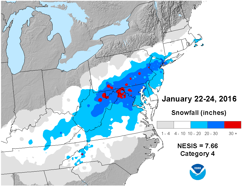
January 22-24 2016 Snowfall
- A powerful winter storm hit the Mid-Atlantic and Northeast from January 22-24, with snow falling from Arkansas to Massachusetts, impacting more than 100 million people. Several cities, including Baltimore, Maryland and New York City, set new all-time snowfall records. Impacts were widespread with power outages, more than 13,000 flight cancellations and severe coastal flooding. On the Northeast Snowfall Impact Scale (NESIS), the storm rated as a Category 4 (Crippling) winter storm and ranked as the fourth most impactful winter storm since 1950. Only winter storms in 1993, 1996, and 1960 ranked higher.
- Drought continued to shrink across much of the U.S. during January, resulting in the smallest drought footprint since October 2010. Several Pacific storms slammed into the West Coast, bringing beneficial precipitation but causing coastal erosion. At higher elevations, above-average mountain snowpack was observed across the Sierra Nevada Mountains, which have been snow starved for several winters. Despite the slightly improved drought conditions in the West, longer-term precipitation deficits persist with exceptional drought continuing for 39 percent of California. Drought conditions were nearly non-existent east of the Rockies.
For extended analysis of regional temperature and precipitation patterns, as well as extreme events, please see our full report that will be released on February 10th.