Monthly Report Summary Information
The Monthly Report Summary Information is a synopsis of the collection of national and global summaries released each month.
National Summary Information - December 2015
See Full Report
For extended analysis of regional temperature and precipitation patterns,as well as extreme events, please see our full report that will be released on January 13th.
Record December boosted 2015 to 2nd warmest year for Contiguous US
Ten weather, climate disasters exceeding $1 billion impacted the nation
The 2015 annual average U.S. temperature was 54.4°F, 2.4°F above the 20th century average, the second warmest year on record. Only 2012 was warmer for the U.S. with an average temperature of 55.3°F. This is the 19th consecutive year the annual average temperature exceeded the 20th century average. The first part of the year was marked by extreme warmth in the West and cold in the East, but by the end of 2015, record warmth spanned the East with near-average temperatures across the West. This temperature pattern resulted in every state having an above-average annual temperature.
The average contiguous U.S. precipitation was 34.47 inches, 4.53 inches above average, and ranked as the third wettest year in the 121-year period of record. Only 1973 and 1983 were wetter. The central and southeastern U.S. was much wetter than average, while parts of the West and Northeast were drier than average. The national drought footprint shrank about 10 percent during the course of the year.
In 2015, there were 10 weather and climate disaster events, each with losses exceeding $1 billion. These events included a drought, two floods, five severe storms, a wildfire event and a winter storm. Overall, these resulted in the deaths of 155 people and had significant economic effects. Further cost figures on individual events in 2015 will be updated when data are finalized later this year.
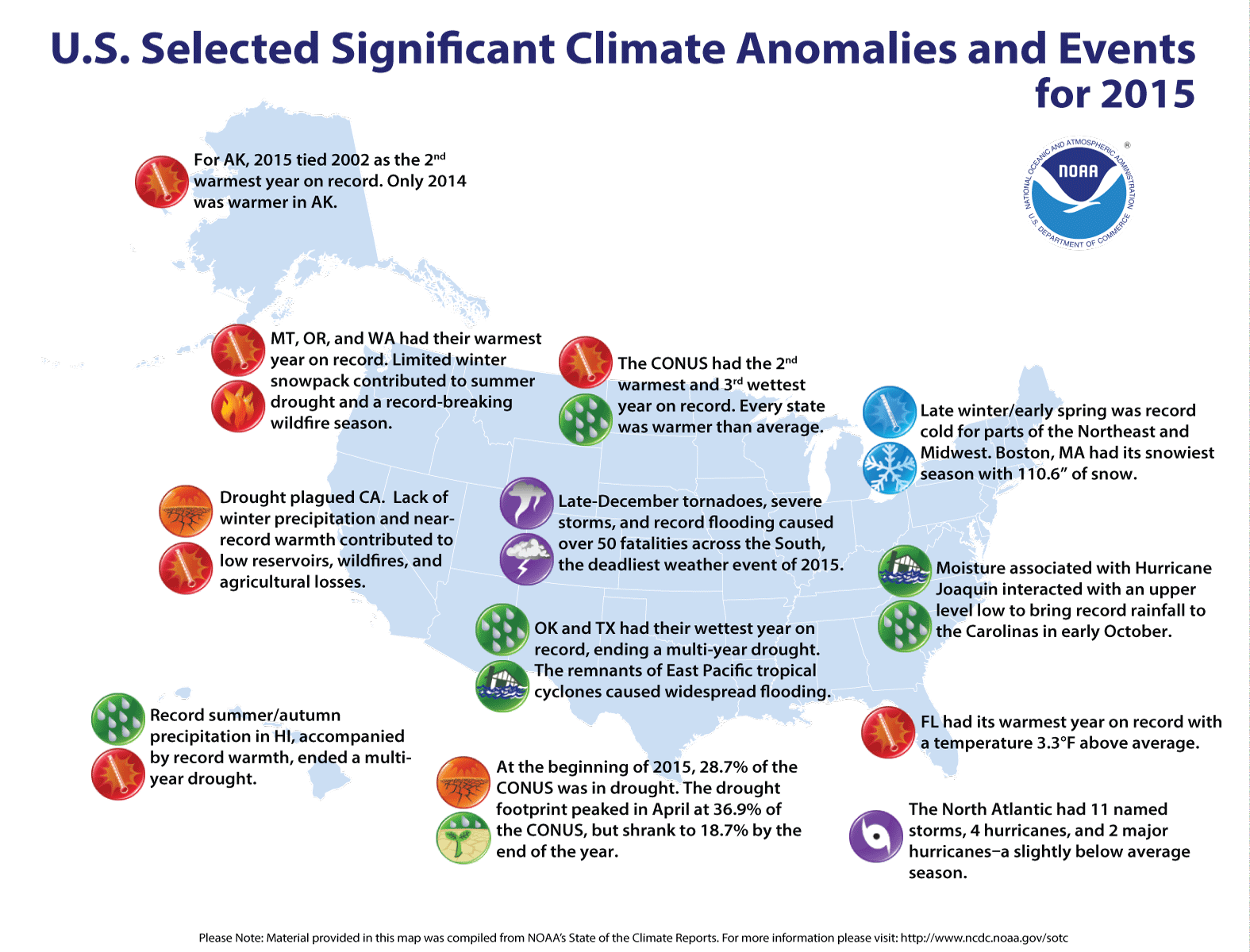
Significant climate events for 2015.
Supplemental 2015 Information
- Annual temperature evolution for select U.S. cities
- Annual precipitation evolution for select U.S. cities
- Annual temperature and precipitation records and near-records
- Regional warmest and wettest years
- Contiguous U.S. temperature horserace
- Contiguous U.S. monthly temperature historical context
- Warmest Decembers on record for Contiguous U.S.
- Warmest years on record for Contiguous U.S.
- Alaska divisional rank maps
- 2015 gridded temperature maps
U.S. climate highlights: 2015
- Much warmer than average annual temperatures were observed across the West, Northern and Central Plains, Southeast, and Mid-Atlantic. Twenty-eight states, including Alaska, were much warmer than average during 2015 — Florida, Montana, Oregon and Washington were record warm. Alaska, California, and Idaho had their second warmest year.
- Most of the central and southeastern U.S. were wetter than average, including 14 states that were much wetter than average. Oklahoma and Texas were record wet for the year, with both states becoming drought free for the first time since 2010. Parts of the Northeast and West were drier than average. Connecticut had its fourth driest year. In California, year-end precipitation helped erase early-year deficits, resulting in the state's 13th driest year.
- The U.S. Climate Extremes Index (USCEI) for 2015 was 70 percent above average, ranking as the fourth highest annual USCEI in the 106-year record and highest since 2012. The components of the USCEI that were much above average for the year included extremes in warm maximum and minimum temperatures, one-day precipitation totals and days with precipitation. The USCEI is an index that tracks extremes (falling in the upper or lower 10 percent of the record) in temperature, precipitation, drought and land-falling tropical cyclones across the contiguous United States.

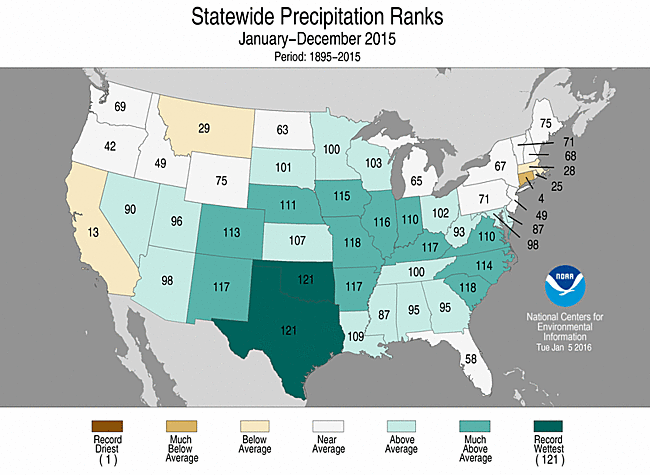
2015 Statewide Temperature (top)
and Precipitation (bottom) ranks
U.S. climate highlights: December 2015


December 2015 Statewide Temperature (top)
and Precipitation (bottom) ranks
- December 2015 was record warm for the contiguous U.S., with a temperature of 38.6°F, 6.0°F above the 20th century average. This broke the previous record of 37.7°F set in 1939. Record warmth engulfed the eastern half of the nation, where 29 states had the warmest December on record. Near- to below-average December temperatures were observed in the West. No state was record cold.
- The December precipitation total for the contiguous U.S. was 3.93 inches, 1.58 inches above the 20th century average, ranking as the wettest December on record. This surpassed the previous record of 3.76 inches set in 1982. Above-average precipitation was observed across the country, with 23 states being much wetter than average. Iowa and Wisconsin had a record wet December.
- A strong low pressure system moved through the central U.S. during the end of December causing record flooding, severe weather, and heavy snowfall. Record crests and overtopped levees were observed along parts of the Mississippi River and its tributaries, deadly tornadoes ripped through the Southern Plains and Mid-South and heavy snow/ice was observed from the Southern Rockies to Midwest and New England. This storm system resulted in at least 50 fatalities across the country — the deadliest weather event of 2015 — and caused over $1 billion in losses, according to preliminary estimates.
- According to the December 29th U.S. Drought Monitor report, 18.7 percent of contiguous U.S. was in drought, down from 20.6 percent at the beginning of the month. Drought conditions dramatically improved across the Pacific Northwest, where record and near-record precipitation was observed during December. Drought also improved in parts of the Central Plains and Upper Midwest. Drought conditions expanded in parts of the Great Lakes and Northeast.
This temperature and precipitation analysis is based on data back to 1895, resulting in 121 years of data. Data for 2015 should be considered preliminary. The most up-to-date temperature and precipitation data is available through NCEI's Climate at a Glance.
For extended analysis of regional temperature and precipitation patterns, as well as extreme events, please see our full report that will be released on January 13th.