Monthly Report Summary Information
The Monthly Report Summary Information is a synopsis of the collection of national and global summaries released each month.
National Summary Information - March 2015
See Full Report
For extended analysis of regional temperature and precipitation patterns,as well as extreme events, please see our full report that will be released on April 10th.

Significant climate events for March 2015
March was 12th warmest on record for the Contiguous United States
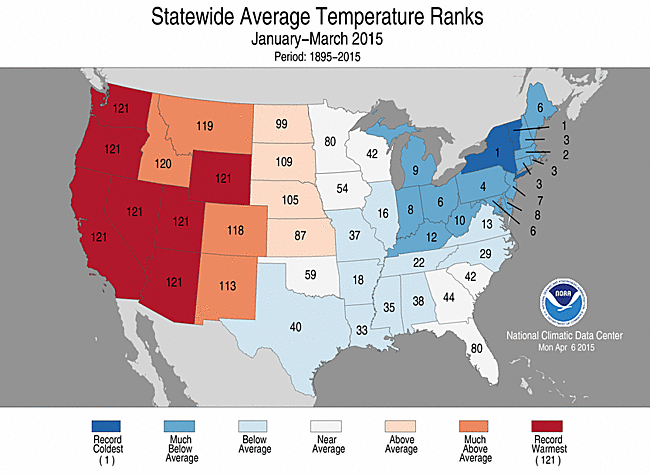
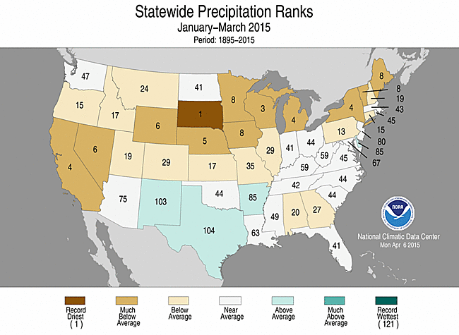
First quarter 2015: Record warmth in the West and cold in the Northeast, dire drought conditions in the West
The March contiguous U.S. average temperature was 45.4°F, 3.9°F above the 20th century average — the warmest March since 2012. Near-record warmth spanned the Great Plains to the West Coast and parts of the Southeast, while the Northeast was cooler than average. The March Lower 48 precipitation total was 2.08 inches, 0.43 inch below average, tying as the 19th driest March on record. Below-average precipitation was widespread across the northern tier states and the Southeast, with above-average precipitation in the Southern Plains and Ohio Valley.
This analysis of U.S. temperature and precipitation is based on data back to January 1895, resulting in 121 years of data.
March


March 2015 Statewide Temperature (top)
and Precipitation (bottom) ranks
- Fifteen states across the Southeast, Northern Plains, and West had a March temperature that was much above average, while five states in the Northeast had a March temperature that was much below average. No state was record warm or cold.
- Below-average precipitation was observed along both the East and West Coasts, connected by drier-than-average states across the northern tier. Twelve states had a March precipitation total that was much below average. Above-average precipitation accumulated from the Southern Plains into the Ohio Valley; Arkansas and Texas were both much wetter than average. No state was record dry or wet.
- According to the March 31st U.S. Drought Monitor report, 36.8 percent of the contiguous U.S. was in drought, up from 31.9 percent at the beginning of March. Drought conditions worsened across parts of the Central Rockies as well as the Central and Northern Plains and the Upper Midwest where spring drought could impact the upcoming growing season. Drought remained entrenched in the West, where mountain snowpack was record low for many locations in the Cascade and Sierra Nevada Mountains. Abnormally dry conditions developed in parts of the Southeast and Northeast. Drought improved in the Southern Plains and the Mid- to Lower-Mississippi River Valley.
U.S. climate highlights: Year-to-date (January-March)
March 2015 Statewide Temperature (top)
and Precipitation (bottom) ranks
- The year-to-date contiguous U.S. average temperature was 37.2°F, 2.0°F above the 20th century average, and the 24th warmest January-March on record. Record warmth engulfed much of the West, where seven states were record warm, and an additional five states, including Alaska, had temperatures that were much above average. California's year-to-date temperature of 53.0°F was 7.5°F above average and bested the previous record set just last year by 1.8°F.
- Below-average January-March temperatures were observed across the South, the Midwest, and Northeast where 16 states had a much cooler-than-average January-March period. New York and Vermont were both record cold for the year-to-date. The New York year-to-date temperature was 16.9°F, 6.8°F below average, dropping below the previous record of 17.4°F set in 1912. The Vermont January-March temperature was 13.3°F, 6.4°F below average, tying the same period in 1923.
- The year-to-date contiguous U.S. precipitation total was 5.66 inches, 1.30 inches below the 20th century average, and the seventh driest January-March on record. This was the driest first three months of a year since 1988. Below-average precipitation was observed across the West and much of the northern half of the nation. Twelve states had much below average precipitation during the first three months of 2015. South Dakota had its driest January-March on record with a precipitation total of 0.85 inch, 1.21 inches below average. Above-average precipitation was observed across the Southern Rockies and Plains.
- The U.S. Climate Extremes Index (USCEI) for the year-to-date was nine percent above average and the 11th highest value on record. The warm West and cold East temperature pattern during January-March contributed to the much above average USCEI, with the components that measure both warm and cold daytime and nighttime temperatures being much above average. The USCEI is an index that tracks extremes (falling in the upper or lower 10 percent of the record) in temperature, precipitation, and drought across the contiguous U.S.
Note: NOAA's National Centers for Environmental Information (NCEI) is the merger of the National Climatic Data Center, National Geophysical Data Center, and National Oceanographic Data Center as approved in the Consolidated and Further Continuing Appropriations Act, 2015, Public Law 113-235. From the depths of the ocean to the surface of the sun and from million-year-old sediment records to near real-time satellite images, NCEI is the Nation's leading authority for environmental information and data. For more information go to http://www.ncdc.noaa.gov/news/coming-soon-national-centers-environmental-information
For extended analysis of regional temperature and precipitation patterns, as well as extreme events, please see our full report that will be released on April 10th.