Monthly Report Summary Information
The Monthly Report Summary Information is a synopsis of the collection of national and global summaries released each month.
National Summary Information - February 2015
See Full Report
For extended analysis of regional temperature and precipitation patterns,as well as extreme events, please see our full report that will be released on March 11th.
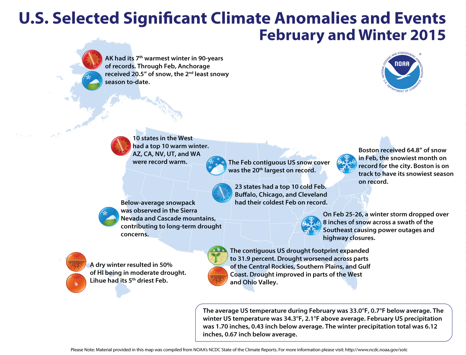
Significant climate events for February 2015
Record winter warmth in the West outweighed cold in the East
19th warmest winter for the contiguous US; February slightly below 20th-century average
The winter contiguous U.S. temperature was 34.3°F, 2.1°F above the 20th century average, but the February temperature was 33.1°F, 0.7°F below the 20th century average, ranking near the median value for February in the 121-year period of record*. Many northeastern states had February average temperatures that were the second coldest on record, with several individual cities being record cold. Record snowfalls were widespread in the East, while record warmth engulfed much of the West.
The February Lower 48 precipitation total was 1.70 inches, 0.43 inch below average, and marked the 20th driest on record. The winter precipitation total was 6.12 inches, 0.67 inch below average, and the 27th driest. Despite near-normal precipitation in February, long-term drought concerns continue in the West, compounded by a lack of mountain snowpack.
*This analysis of U.S. temperature and precipitation is based on data back to January 1895, resulting in 121 years of February data and 120 years of winter (December-February) data.
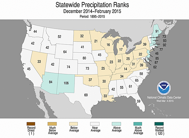
U.S. climate highlights: winter (December 2014-February 2015)

February 2015 Statewide Temperature (top)
and Precipitation (bottom) ranks
- Arizona, California, Nevada, Utah, and Washington each had their warmest winter on record. In California, the winter temperature bested the previous seasonal record that occurred just last year by 1.5°F. An additional five states, from the Rockies to West Coast, including Alaska, had one of their 10 warmest winters on record.
- Below-average winter temperatures, driven in large part by a frigid February, were observed from the Mississippi River to the East Coast. Due to a mild first half of winter, no state had winter temperatures that ranked among the 10 coldest on record.
- Below-average winter precipitation was observed across parts of the Great Basin, Upper Midwest, Mid-South, Great Lakes, and Mid-Atlantic. Above-average precipitation was observed in the Southern Rockies. No state had winter precipitation totals that ranked among the 10 driest or wettest on record.
- The U.S. Climate Extremes Index (USCEI) for winter was 15 percent above average, ranking as the 30th largest winter USCEI on record. The components that examine extremes in warm daily maximum and minimum temperatures and 1-day precipitation totals were much above average. The USCEI is an index that tracks extremes (falling in the upper or lower 10 percent of the record) in temperature, precipitation, and drought across the contiguous U.S.
U.S. climate highlights: February 2015


February 2015 Statewide Temperature (top)
and Precipitation (bottom) ranks
- The western U.S. was warmer than average, where eight states had a top 10 warm February. Arizona, California, Utah, and Washington each had their warmest February on record.
- Locations from the Mississippi River to the East Coast were colder than average, where 23 states had a top ten coldest February. While no state was record cold during February, nine states had their second coldest February. Several cities in the Northeast had their coldest month of any month on record including Buffalo, New York where the monthly average temperature was 10.9°F, dipping below the 11.6°F observed in February 1934.
- Most states across the contiguous U.S. had near to below-average monthly precipitation, with the exception of Colorado which was wetter than average. No state had February precipitation totals that ranked among the 10 wettest or driest on record.
- According to analysis of NOAA data by the Rutgers Global Snow Lab, the February contiguous U.S. snow cover extent was 1.3 million square miles, 91,000 square miles above the 1981-2010 average. This marked the 20th largest February snow cover extent in the 49-year period of record. Below-average snow cover and snowpack was observed across much of the West, while above-average snow cover was observed in the East. The Northeast was particularly snowy, where Boston, Massachusetts had its snowiest month of any month since records began there in 1872 with 64.8 inches of snow, besting the previous record of 43.3 inches set in January 2005.
- According to the March 3rd U.S. Drought Monitor report, 31.9 percent of the contiguous U.S. was in drought, up from 28.4 percent at the beginning of February. Drought conditions worsened across parts of the Central Rockies, Southern Plains, and central Gulf Coast. Drought conditions improved in parts of the West and Ohio Valley. Abnormally dry conditions developed across central parts of Alaska.
Note: With this report and data release, the National Climatic Data Center added historical Alaska climate divisions to its nClimDiv dataset. The new temperature and precipitation data for the 13 Alaskan climate divisions dates back to 1925 and will be updated monthly with our contiguous U.S. nClimDiv dataset. This newly expanded dataset improves the climate services that NOAA provides to the state of Alaska. For more information please visit the Alaska Climate Divisions FAQ.
For extended analysis of regional temperature and precipitation patterns, as well as extreme events, please see our full report that will be released on March 11th.