Monthly Report Summary Information
The Monthly Report Summary Information is a synopsis of the collection of national and global summaries released each month.
National Summary Information - September 2014
See Full Report
September was warmer than average for the contiguous US
The East Coast and West were warmer than average, while the Midwest was cool; The Southwest was wet, the Northeast was near-record dry, and drought persisted in California.
The average temperature for the contiguous U.S. during September was 66.2°F, 1.3°F above the 20th century average. This was the 26th warmest September on record for the Lower 48 and the coolest since 2011. The September precipitation total for the contiguous U.S. was 2.58 inches, 0.09 inch above average - ranking near the median value in the 120-year period of record.

Significant climate events for September 2014.
Click image to enlarge, or click here for the National Overview.
Note: The September Monthly Climate Report for the United States has several pages of supplemental information and data regarding some of the exceptional events from the month, season, and year-to-date.
Major climate events NOAA is closely monitoring:
- Persisting drought in parts of the West: Heavy precipitation during September improved short-term drought conditions across the Southwest. Along the Pacific Coast, precipitation was insufficient to significantly improve drought conditions, with drought still impacting all of California. The long-term drought conditions across the region will continue to impact water resources and agriculture and increase wildfire risk. More information is available from the U.S. Drought Monitor.
- El Niño still probable later this year: According to NOAA's Climate Prediction Center, there is a 2-in-3 chance of at least a weak El Niño developing during the next 1-2 months and lasting into spring 2015. El Niño conditions could impact temperature and precipitation patterns across the U.S. More information is available from NOAA's Climate Prediction Center.
- Transition to the cold season: September marks the end of the warm season for the United States, and over the next month freezing temperatures will bring an end to the growing season for most locations. Freezing temperatures typically impact high-elevation and northern locations first and expand southward as autumn progresses.
U.S. climate highlights: September 2014
- Locations from the Rockies westward were warmer than average during September. California, Nevada and Utah each had one of the 10 warmest Septembers on record. Much of the East Coast was also warmer than average. Near- to below-average temperatures were observed across much of the Plains and the Midwest.
- The near-average September precipitation total for the contiguous U.S. masked regional extremes. The Southwest was much wetter than average, where enhanced monsoonal flow and the remnants of Hurricanes Norbert and Odile brought an abundance of moisture to the region. Arizona, New Mexico and Utah each had a top 10 wet September. Much of the Mid-Atlantic and Northeast were drier than average, where Connecticut, Maine, Massachusetts, New Hampshire, Rhode Island, and Vermont each had one of the 10 driest Septembers on record.
- According to the September 30 U.S. Drought Monitor report, 30.6 percent of the contiguous U.S. was in drought, down from 32.8 percent at the beginning of the month. Drought conditions improved across the Southwest, Great Basin, Central Plains, and southern Georgia, while drought conditions worsened in parts of the Southern Plains, where the Dallas/Fort Worth metro area saw a reintroduction of exceptional drought for the first time in three years. Worsening conditions also occurred in the Southeast and Northeast, with abnormally dry conditions developing in the Mid-Atlantic. Drought continued to impact California and Nevada, with nearly 100 percent of both states in moderate-to-exceptional drought.
- Alaska was warmer and slightly wetter than average during September. The state had its 11th warmest September on record with a temperature 2.5°F above the 1971-2000 average. Locations in western Alaska were particularly warm; Cold Bay had its warmest September on record. Alaska's September precipitation total was 9.0 percent above the 1971-2000 average.
- The end of September was particularly warm for Hawaii, with several daily and monthly temperature records being broken. On September 26, the temperature at Hilo reached 93°F besting the all-time September temperature record for the city set on September 21, 1951. This was also 1°F shy of the all-time warmest temperature on record at Hilo, which occurred in November 2013.

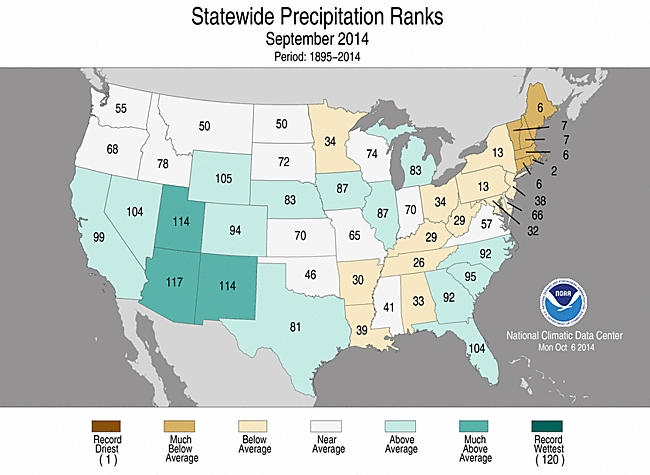
September 2014 Statewide Temperature (top)
and Precipitation (bottom) ranks
U.S. climate highlights: year-to-date (January–September) 2014
- The January-September contiguous U.S. temperature was 55.3°F. This was 0.2°F above the 20th century average, but also marked the coldest first nine months of a year since 1996. The West continued to be much warmer than average, where six states had a top 10 warm year-to-date. California was record warm for January-September, with a temperature 4.1°F above its 20th century average. The East was cooler than average, particularly the Midwest and the Mississippi River Valley, where January-September 2014 was among the 10 coldest such periods in nine states. No state was record cold.
- The year-to-date national precipitation total was 23.67 inches, 0.47 inch above the 20th century average. Above-average precipitation spanned the northern tier, where Wisconsin had its ninth wettest year-to-date. Below-average precipitation was observed in parts of the West, Southern Plains, Mid-Atlantic and Northeast.
- The U.S. Climate Extremes Index (USCEI) for the January-September period was the 19th highest in the 105-year period of record at 35 percent above average. The elevated year-to-date USCEI value was partially due to extremes in both warm and cool daily maximum and minimum temperatures, reflecting the dominant warm-west/cold-east pattern entrenched throughout the year. The component that examines extremes in one-day precipitation totals was also above average. The USCEI is an index that tracks extremes (falling in the upper or lower 10 percent of the record) in temperature, precipitation, drought and land-falling tropical cyclones across the contiguous U.S.
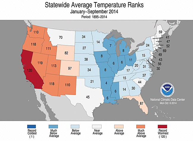
 January–September 2014 Statewide Temperature (top)
 and Precipitation (bottom) ranks