Monthly Report Summary Information
The Monthly Report Summary Information is a synopsis of the collection of national and global summaries released each month.
National Summary Information - December 2014
See Full Report
For extended analysis of regional temperature and precipitation patterns,as well as extreme events, please see our full report that will be released on January 12th.
2014 U.S. temperature exceeds 20th-century average for the 18th consecutive year
Second warmest December boosted 2014 to 34th warmest year for contiguous U.S; eight weather and climate disasters exceeded $1 billion in damages
The 2014 annual average contiguous U.S. temperature was 52.6°F, 0.5°F above the 20th century average. Very warm conditions dominated the West, with four states having their warmest year on record, while the Midwest and Mississippi Valley were cool. This ranked as the 34th warmest year since we began keeping track in the 1895, while the temperature exceeded the 20th Century average for the 18th consecutive year.
The average contiguous U.S. precipitation was 30.76 inches, 0.82 inch above average, and ranked as the 40th wettest year in the 120-year period of record. The Northern U.S. was wet, and the Southern Plains were dry; the national drought footprint shrank about 2 percent.
In 2014, there were eight weather/climate disaster events with losses exceeding $1 billion each across the United States. These eight events resulted in the deaths of 53 people. The events include: the western U.S. drought, the Michigan & Northeast flooding event, five severe storm events, and one winter storm event.

Significant climate events for 2014.
U.S. climate highlights: 2014
- The West was warmer than average for much of 2014. Nine states had a top 10 warm year. Alaska, Arizona, California, and Nevada each had their warmest year on record. Most locations from the Rockies to the East Coast were cooler than average, with the exception of New England and Florida. Seven states across the Midwest and Mississippi River Valley had a top 10 cool year. No state was record cold during 2014.
- The Pacific Northwest, Northern Rockies, Midwest, and Northeast were all wetter than average. Michigan and Wisconsin each had their seventh wettest year on record. The Southern Plains and parts of the Ohio Valley were drier than average, but no state was top 10 dry. The rest of the contiguous U.S. had near-average annual precipitation totals.
- The U.S. Climate Extremes Index (USCEI) for 2014 was 35 percent above average, ranking as the 19th highest annual USCEI in the 105-year record. The components of the USCEI that were much above average for the year included warm nighttime temperatures and 1-day precipitation totals. The USCEI is an index that tracks extremes (falling in the upper or lower 10 percent of the record) in temperature, precipitation, drought, and land-falling tropical cyclones across the contiguous U.S.


2014 Statewide Temperature (top)
and Precipitation (bottom) ranks
U.S. climate highlights: December 2014
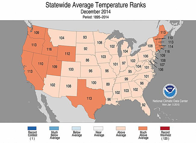
December 2014 Statewide Temperature (top)
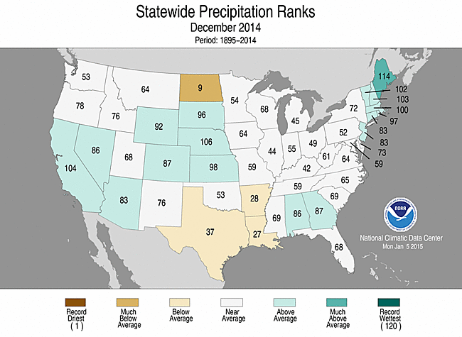
and Precipitation (bottom) ranks
- During December, the average contiguous U.S. temperature was 37.1°F, 4.5°F above the 20th century average. This ranked as the second warmest December on record, and the warmest since 1939. Every state in the contiguous U.S. had above-average December temperatures, with nine states across the West, Southern Plains, and Northeast having a top 10 warm December. No state was record warm.
- The December total precipitation for the contiguous U.S. was 2.51 inches, 0.16 inch above the 20th century average. This ranked near the median value in the 120-year period of record. Above-average precipitation was observed across the West, Central Plains, Southeast, and Northeast. Maine had its seventh wettest December on record. Below-average precipitation was observed across the Southern Plains and Northern Plains. North Dakota had its ninth driest December. No state had its wettest or driest December on record.
- According to the December 30th U.S. Drought Monitor, 28.7 percent of the contiguous U.S. was in drought, down from 29.1 percent at the end of last month. Drought conditions improved across parts of Northern California, the Southeast, and the Northeast, but worsened across parts of the Northern Plains, Southern Plains, and Lower Mississippi River Valley. Despite above-average precipitation in California, only modest drought improvements occurred due to long-term precipitation deficits.
For extended analysis of regional temperature and precipitation patterns, as well as extreme events, please see our full report that will be released on January 12th.