Monthly Report Summary Information
The Monthly Report Summary Information is a synopsis of the collection of national and global summaries released each month.
National Summary Information - February 2013
See Full Report
Contiguous U.S. warmer and wetter than average for winter season
February temperatures and precipitation near-normal; Drought conditions improve for Southeast and Midwest and persist for much of Plains and West.
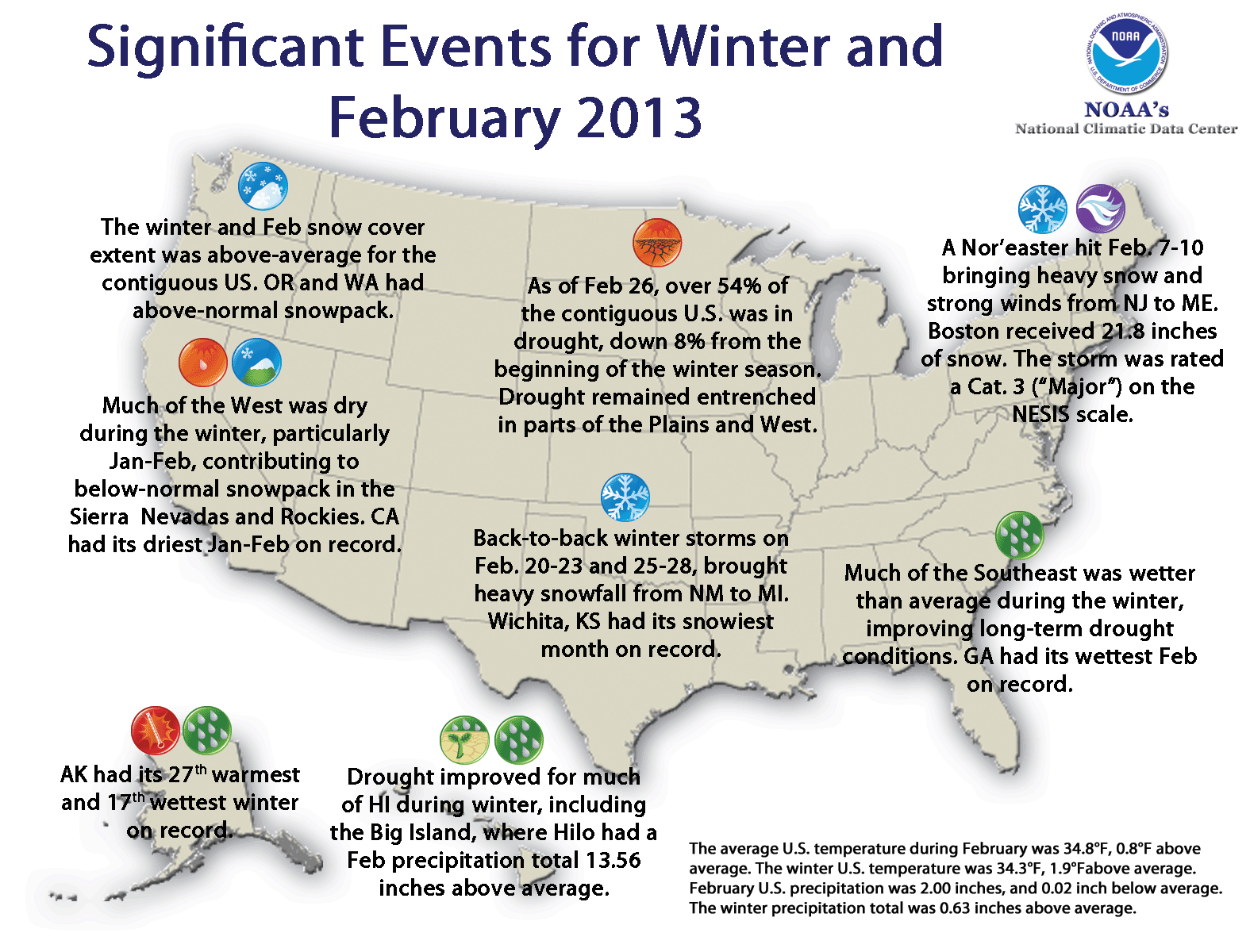
The average temperature for the contiguous U.S. during the winter season (December 2012 — February 2013) was 34.3°F, 1.9°F above the 20th century average, marking the 20th warmest winter on record. The February temperature for the contiguous U.S. was 34.8°F, 0.8°F above average.
The total winter precipitation averaged across the contiguous United States was 7.10 inches and this was 0.63 inches above the 20th century average. February contributed 2.00 inches to this total, which was near the long-term average. During February, several winter storms impacted the nation, improving drought conditions across the Southeast and Midwest, but lighter precipitation totals across the Central Plains and Mountain West provided little drought relief.
Significant climate events for February 2013.
Click image to enlarge, or click here for the National Overview.
Note: The February/Winter Monthly Climate Report for the United States has several pages of supplemental information and data regarding some of the weather/climate events from the month.
U.S. climate highlights: February
-
Canadian-border states and parts of the Gulf Coast were warmer than average.

 February 2013 Statewide Temperature (top) and Precipitation (bottom) ranks
- Three major winter storms impacted the nation during February, contributing to an above-average monthly snow cover extent, according to data from the Rutgers Global Snow Lab. A Nor’easter hit the East Coast on February 7-10, dropping over 30 inches of snow in parts of New England. The storm was rated a Category 3, a “major” winter storm, on the Northeast Snowfall Impact Scale (NESIS), which takes into account snowfall accumulation in the densely populated areas of the northeastern United States. Back-to-back winter storms hit the central U.S. on February 20-23 and 25-28, bringing heavy snowfall totals and near blizzard conditions from New Mexico to Michigan.
- The February nationally-averaged precipitation total was near-average but masked Oregon’s precipitation total of 1.20 inches was 2.00 inches below average and marked the seventh driest February for the state.
- Rhode Island had its third wettest.
- Georgia had its wettest February on record with 9.92 inches of precipitation, 5.42 inches above average. The above-average precipitation drastically improved drought conditions which have been present since the summer of 2010. Neighboring Alabama had its fourth wettest February and South Carolina its seventh wettest.
- According to the February 26 U.S. Drought Monitor report, 54.2 of the contiguous U.S. was experiencing moderate-to-exceptional drought, smaller than the 57.7 percent at the end of January. Drought conditions continued to plague much of the Great Plains and West.
U.S. climate highlights: Winter Season (December 2012 — February 2013
- Winter was warmer than average for all states Northwest.
- The above-average temperatures were accompanied by Below-average precipitation occurred from the West Coast through the Northern Plains and Rockies.
- Alaska was warmer and wetter than average during the 2012-13 winter season. The statewide average temperature average was 2.0°F above average and the 27th warmest 3-month period in the 95-year period of record. The Alaskan winter precipitation total was 32.2 percent above average and the 17th largest seasonal value on record.
- According to data from the Rutgers Global Snow Lab, the winter average snow cover extent for the contiguous U.S. was 1.3 million square miles, which was 127,000 square miles above the 1981-2010 average. This marked the 15th largest seasonal snow cover extent in the 1966-present period of record.

 Winter 2012–2013 Statewide Temperature (top) and Precipitation (bottom) ranks
U.S. climate highlights: Year-to-Date (January — February 2013)
- The first two months of 2013 were warmer than average for the contiguous U.S. with a nationally-averaged temperature of 33.3°F, 1.2°F above average. Near- and above-average temperatures were recorded Utah had its 12th coolest January — February, with temperatures 5.3°F below average.
- The January — February precipitation total for the U.S. was 4.36 inches, just 0.12 inch below average. The West and Northeast were both Above-average precipitation was present for parts of the Midwest and Gulf Coast, where seven states were top ten wet.