Monthly Report Summary Information
The Monthly Report Summary Information is a synopsis of the collection of national and global summaries released each month.
National Summary Information - December 2013
See Full Report
2013 warmer and wetter than average for the contiguous US
Seven weather and climate disasters exceeded $1 billion in damages; national drought footprint shrank drastically though intensified in Far West
The average temperature for the contiguous U.S. during 2013 was 52.4°F, 0.3°F above the 20th century average, tying with 1980 as the 37th warmest year in the 119-year period of record. The year consisted of a warmer-than-average winter, summer, and autumn, and a cooler-than-average spring.
For the year, the average precipitation total for the contiguous U.S. was 31.17 inches, 2.03 inches above the 20th century average. This marked the 21st wettest year on record and the wettest since 2009. California was record dry, while Michigan and North Dakota were record wet; Alaska had its third wettest year.

Significant weather and climate events for 2013
Click image to enlarge, or click here for the National Overview.
Note: The Annual Climate Report for the United States has several pages of supplemental information and data regarding some of the exceptional events 2013.
2013 Extremes
- In 2013, the U.S. experienced seven weather and climate disaster events, each with losses exceeding $1 billion in damages. These events included five severe weather and tornado events, a major flood event, and the western drought / heat wave. Overall, these events killed 109 people and delivered significant economic effects.
- The 2013 U.S. billion-dollar events include:
- Southeast severe weather event on March 18
- Midwest / Plains severe weather event on April 7-11
- Midwest / Plains / East tornadoes on May 18-22
- Midwest / Plains / Northeast tornadoes on May 27-31
- Colorado floods on September 10-16
- Western drought / heatwave from March to September.
- late-season Ohio Valley tornado outbreak on November 17
- Drought conditions improved substantially across much of the southeastern and central U.S. during 2013, but deteriorated in the Far West. According to the U.S. Drought Monitor, at the end of 2013, about 31.0 percent of the contiguous U.S. was experiencing drought, down from 61.1 percent at the beginning of the year.
- There were few tornado outbreaks in 2013 with the two most active days coming in late January and mid-November. During May, there were a number of intense and destructive tornadoes, including the EF5 Moore, Okla. tornado. The total number of tornadoes for the year will be around 900, the lowest annual count since 1989. The annual average number of tornadoes in the U.S. is approximately 1,250.
- According to NOAA's National Hurricane Center, 13 tropical storms formed during the 2013 North Atlantic hurricane season. The annual number of tropical storms was slightly above average. Two hurricanes, Humberto and Ingrid, developed during the season, neither of which strengthened into a major hurricane. The number of hurricanes and major hurricanes was well below average. The last time only two hurricanes were observed in the North Atlantic was in 1982. The last season with no major hurricanes was 1994.
- The U.S. Climate Extremes Index (USCEI) was slightly below average during 2013, marking the first time since 2009 with a below average annual USCEI. The components of the UCSEI that examine extremes in the spatial extent of drought, one-day precipitation totals, and days with precipitation were all above average. The USCEI is an index that tracks the highest and lowest 10 percent of extremes in temperature, precipitation, tropical cyclones, and drought across the contiguous United States.
-
The year brought above-average temperatures to the Northeast, the West, and Florida, while below-average temperatures were observed from the Northern Plains, through the Central Plains and Midwest, and into the Southeast. No state had annual temperatures that ranked among the 10 warmest or coolest on record.
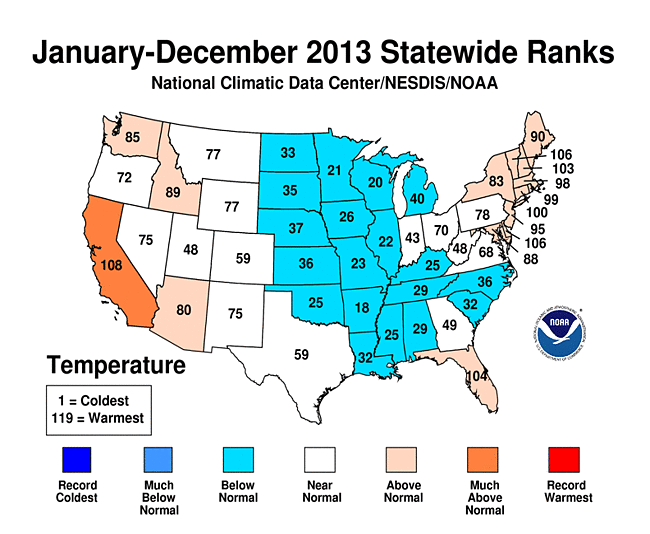
2013 Statewide Temperature Ranks - Alaska had its 10th warmest year in the 95-year period of record with a temperature 1.8°F above the 1971-2000 average. This was the warmest year for Alaska since 2005. Temperatures peaked during the summer, which was the second warmest such season on record for the state, behind summer 2004, with a temperature 2.7°F above average.
- For the contiguous U.S., 2013 started off warmer than average, with the 20th warmest winter (December 2012-February 2013) on record. The nationally averaged temperature of 34.3°F was 1.9°F above the 20th century average for the season. States east of the Rockies were warmer than average, particularly parts of the Northeast and Florida. Below-average winter temperatures were present for the parts of the West.
- Spring was cooler-than-average for the contiguous U.S. with a seasonal temperature of 50.4°F, 0.5°F below average. This was the coolest spring since 1996. On a statewide level, below-average temperatures were present from the Northern Plains to the Southeast, where 12 states had a top 10 cool spring. The West was warm, where Arizona and California had a top 10 warm spring.
- The summer tied with 1937 as the 15th warmest summer on record for the Lower-48 with an average temperature of 72.6°F, 1.3°F above average. This was the coolest summer for the nation since 2009. In the West, eight states had a top 10 warm summer, in addition to Massachusetts in the Northeast. Below-average summer temperatures were observed in the Midwest and Southeast.
- The average autumn temperature for the contiguous U.S. was 54.1°F, 0.5°F above average, ranking near the median value for the season. Much of the nation had near-average autumn temperatures. December 2013 was cold with an average temperature of 30.9°F, 2.0°F below the 20th century average, and the 21st coldest December on record. Below-average temperatures dominated the northwestern and central U.S., with above-average temperatures in the Southeast.
-
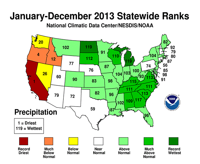
Much of the U.S. east of the Rockies had above-average precipitation during 2013. Ten states, in the Northern Plains, Midwest, and Southeast, had one of their 10 wettest years on record, with numerous cities breaking long-standing records for their wettest year on record. Michigan and North Dakota both experienced their wettest year on record.
 2013 Statewide Precipitation Ranks
- The West was dry during 2013. California had its driest calendar year on record with a statewide average precipitation 2.42 inches less than the previous record dry year of 1898. By the end of 2013, 27.6 percent of California was in Severe Drought. Just to the north, Oregon had its fourth driest year on record.
- Alaska had its third wettest year on record with a precipitation total 25.1 percent above the 1971-2000 average. Only 1929 and 1963 were wetter for Alaska.
- Each season of 2013 had precipitation totals that were above average for the contiguous United States. The summer season (June-August) was the most unusually wet, with a precipitation total 15 percent above average — the eighth wettest summer on record and the wettest since 2004.