Monthly Report Summary Information
The Monthly Report Summary Information is a synopsis of the collection of national and global summaries released each month.
Global Summary Information - September 2014
See Full Report
September global temperature reaches record high;
January–September global temperature ties as record highest
The globally averaged temperature over land and ocean surfaces for September 2014 was the highest for September since record keeping began in 1880. It also marked the 38th consecutive September with a global temperature above the 20th century average. The last below-average global temperature for September occurred in 1976.

Global temperature highlights: September
- The average temperature over global land and ocean surfaces combined for September 2014 was the record highest for the month, at 60.30°F (15.72°C) or 1.30°F (0.72°C) above the 20th century average. The margin of error associated with this temperature is ±0.22°F (0.12°C). With the exception of February, every month to date in 2014 has been among its four warmest on record, with May, June, August, and September all record warm.
- September marked the 38th consecutive September with a global temperature above the 20th century average. The last below-average temperature for September occurred in 1976.
- The global land temperature was the sixth highest for September on record, at 1.60°F (0.89°C) above the 20th century average. The margin of error is ±0.43°F (0.24°C). Warmer-than-average temperatures were evident over most of the global land surface, except for central Russia, some areas in eastern and northern Canada, and a small region in Namibia. Record warmth was notable in much of northwestern Africa, coastal regions of southeastern South America, southwestern Australia, parts of the Middle East, and regions of southeastern Asia.
- Some national highlights are included below:
- The September maximum temperature for Australia was 3.65°F (2.03°C) higher than the 1961–1990 average, the fifth highest for the month since national records began in 1910. The state of Western Australia was record warm at 4.95°F (2.75°C) above average, breaking the previous record set in 1980 by 0.79°F (0.44°C). Tasmania reported its second highest September maximum temperature on record and Victoria its seventh highest.
- Many countries in Europe were warmer than average during September, including Norway, Germany, Finland, Austria, and France. Denmark reported its seventh warmest September since national records began in 1874, while the United Kingdom had its fourth warmest in the country's 115-year period of record.
- For the ocean, the September global sea surface temperature was 1.19°F (0.66°C) above the 20th century average, the highest on record for September. This also marked the highest departure from average for any month since records began in 1880, breaking the previous record of 1.17°F (0.65°C) set just one month earlier in August. This is the third time in 2014 this all-time record has been broken. The margin of error is ±0.09°F (0.05°C). Record warmth was observed in parts of every major ocean basin, particularly notable in the northeastern and equatorial Pacific Ocean.
- Although El Niño conditions were not officially present across the central and eastern equatorial Pacific Ocean during September 2014. NOAA's Climate Prediction Center favors El Niño to begin in the next one to two months and last into the Northern Hemisphere spring 2015.

September 2014 Blended Land & Sea Surface Temperature Percentiles
Snow and ice highlights: September
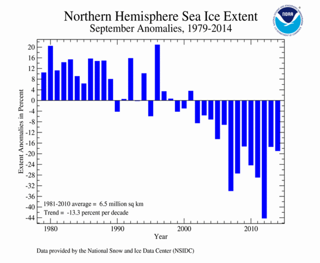
- On September 17, Arctic sea ice reached its annual minimum extent at 1.94 million square miles, the sixth smallest in the 1979–2014 satellite record, according to the National Snow and Ice Data Center. This was 463,000 square miles below the 1981–2010 average, but 622,000 square miles larger than the record small minimum that occurred in 2012. Between the annual maximum extent that occurred in March and the minimum extent, the Arctic lost 3.82 million square miles of ice during the 2014 melt season, the ninth most on record but the least since 2006.
- The average September Arctic sea ice extent was 2.04 million square miles, 480,000 square miles (19.02 percent) below the 1981–2010 average and the sixth smallest on record. Much-below-average sea ice was observed in the Laptev, Kara and Chukchi Seas; above-average sea ice was observed in the Barents Sea. Near-average ice extent in the Canadian Archipelago caused the Northeast Passage to remain closed, unlike recent Septembers when the sea route was navigable by ship.
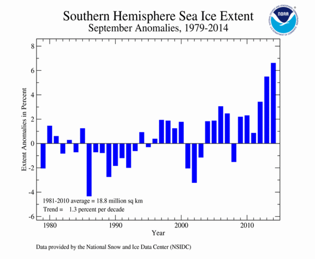
- Antarctic: On September 22, Antarctic sea ice reached its annual maximum extent at 7.76 million square miles, 595,000 square miles above the 1981–2010 average and the largest maximum Antarctic sea ice extent in the 1979–2014 satellite record. This beat the previous record set just last year by approximately 216,000 square miles and marked the third consecutive year that a new record maximum sea ice extent has been set in the Antarctic.
- The average September Antarctic sea ice extent was 7.73 million square miles, 480,000 square miles (6.60 percent) above the 1981–2010 average. This was the largest September average Antarctic sea ice extent on record and the largest average Antarctic sea ice extent for any month. This bested the previous September Antarctic sea ice extent record set last year by approximately 80,000 square miles. Much-above-average sea ice was observed in the western Pacific and Indian Ocean areas.
Precipitation highlights: September
- As is typical, extreme wet and extreme dry conditions were scattered across the globe. Select notable events include the following:
- High pressure systems not only brought warmth to the UK during September, but also record dryness. The country had its driest September since records began in 1910, with just 20 percent of average rainfall for the month. Besides breaking the record itself, this rainfall deficit is particularly notable because the preceding eight-month period of January–August was the wettest such period on record for the country.
- The Southwest Indian Monsoon began its annual withdrawal in September, but the withdrawal began later than normal. From June 1 to September 30, India as a whole received 88 percent of average seasonal rainfall for the period. All regions were below average, with Northwest India experiencing the greatest precipitation deficit, receiving 79 percent of average rainfall. Most of the below-average rainfall for India can be attributed to below-average precipitation during June and early July. In early September, the northern state of Jammu and Kashmir, along with the neighboring region in Pakistan, experienced intense flooding from downpours that brought over a foot of rain. More than 400 residents perished due to the disaster.
- The combined average temperature over global land and ocean surfaces for January–September tied with 1998 as the warmest such period on record, at 1.22°F (0.68°C) above the 20th century average of 57.5°F (14.1°C). If 2014 maintains this temperature departure from average for the remainder of the year, it will be the warmest year on record. The margin of error associated with this temperature is ±0.20°F (0.11°C).
- The January–September worldwide land surface temperature was 1.75°F (0.97°C) above the 20th century average, the sixth warmest such period on record. The margin of error is ±0.41°F (0.23°C).
- The global sea surface temperature for the year to date was 1.03°F (0.57°C) above the 20th century average, the warmest such period on record. The margin of error is ±0.09°F (0.05°C).