Overview:
During May, the annual snow retreat across the contiguous U.S. occurred in earnest with the return of warmer, seasonal temperatures. One snow storm impacted the Central Rockies in mid-May, causing a temporary increase in the national snow footprint. According to NOAA's National Snow Analysis, at the beginning of May, 5.7 percent of the contiguous U.S. had snow on the ground — the highest terrain in the West, parts of the northern Upper Midwest, and far northern New England. Snow cover peaked during the month on May 12th with 8.6 percent of the Lower 48 having snow on the ground. By the end of May, 1.4 percent of the contiguous U.S. had snow on the ground — the highest terrain in the Central and Northern Rockies and the Cascades. The lack of snowstorms to impact the Upper Midwest during May caused Duluth and International Falls in Minnesota to have the second lowest May snow totals on record; this is in contrast to the rest of the snow season that brought much-average snow to the region.
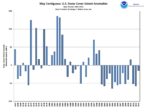
According to NOAA data analyzed by the Rutgers Global Snow Lab, the May snow cover extent for the contiguous U.S. was approximately 50,000 square miles, which was about 15,000 square miles below the 1981-2010 average, marking the 22nd smallest (27th largest) May snow cover extent in the 48-year period of record. Above-average snow cover extent was observed across parts of the Central Rockies, while below-average snow cover extent was observed in the Northern Rockies, the Pacific Northwest, and the Sierra Nevada mountains. For the spring season (March-May), the contiguous U.S. snow cover extent was 28,000 square miles above the 1981-2010 average, ranking as the 21st largest (28th smallest) spring snow cover extent on record. A warm and dry spring in Alaska contributed to the state having its record smallest May snow cover extent on record at 252,000 square miles, 134,000 square miles below the 1981-2010 average. Much of the state had below-average May snow cover, with the exception of the North Slope.
Summary of Notable Snow Events:
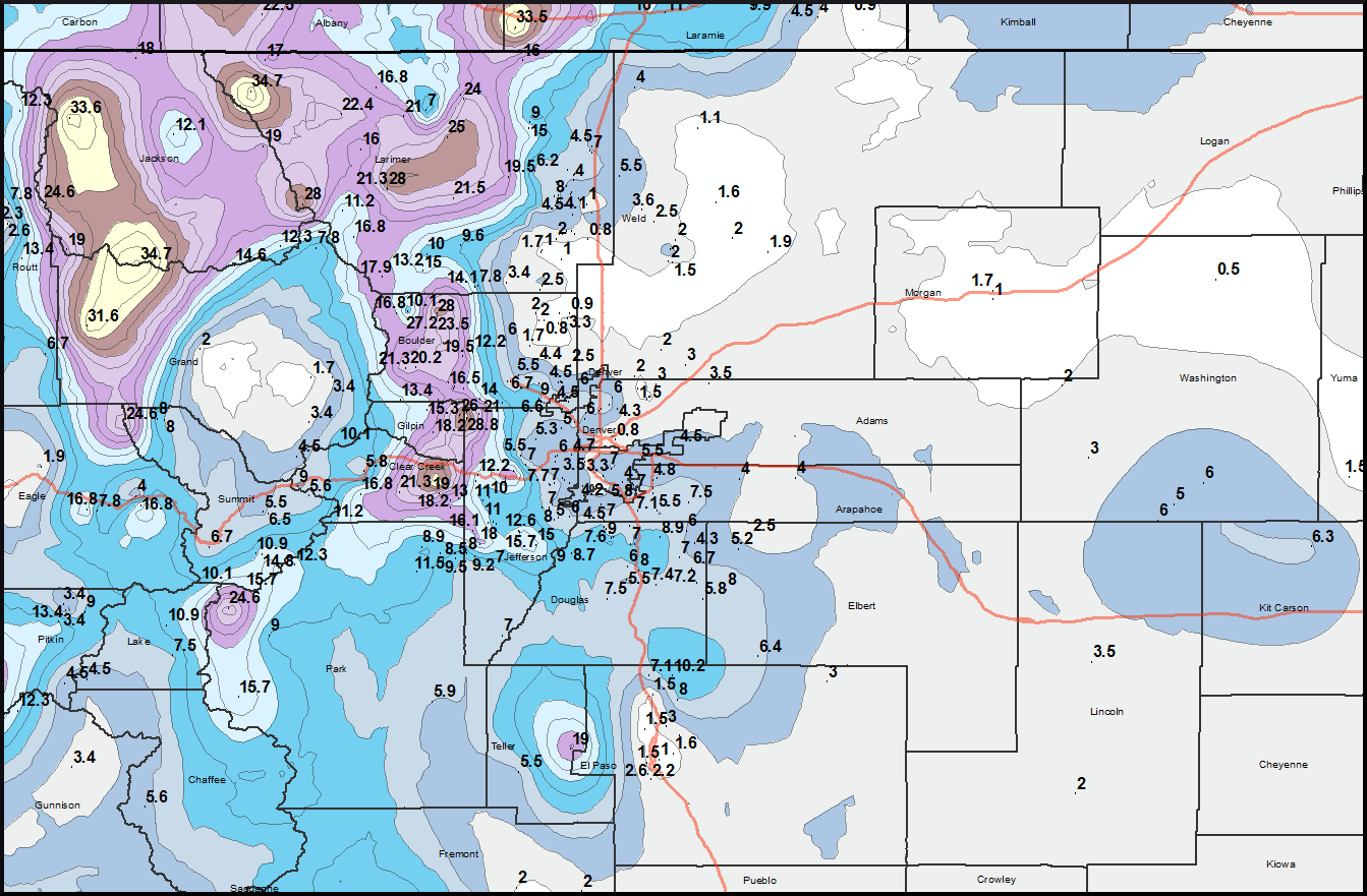
From May 11th to 13th a late-season snow storm impacted the Central Rockies and Front Range, bringing widespread heavy snow. A Pacific low pressure system pushed inland, across the Central Rockies, as a colder air mass was moving in from Canada. The largest snow totals occurred across the highest elevations. Over 40 inches of snow was observed in parts of Wyoming, with over 30 inches occurring at several locations in Colorado. Parts of the Denver metro area received over five inches of snow. Snowfall totals broke several daily records. The 12.0 inches that fell in Cheyenne, Wyoming, was the heaviest single-day snowfall this late in the season. It should be noted that snow totals over six inches have been reported several times in June in Cheyenne. Snow was also observed in parts of Utah, New Mexico, and Nebraska. The largest impacts from the event were snapping trees and highway closures. Approximately 17,000 homes lost power, while much of Interstate 80 was closed for up to 24 hours across Wyoming. The snow on the ground was short lived, with warmer conditions moving into the region shortly after the storm.
This will be the last U.S. snow report issued until the October 2014 report is released in November 2014.
 NOAA's National Centers for Environmental Information


