
Overview:
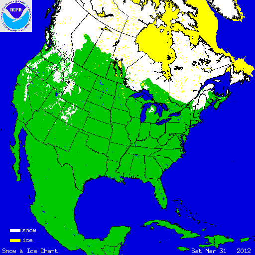
During March, an amplified weather pattern brought record and near-record warm temperatures to the eastern two-thirds of the nation, limiting snowfall for a large area of the country. Across the Pacific Northwest, which experienced below-average temperatures for the month and above-average precipitation, snowfall was plentiful, as several large Pacific storms impacted the region. At the beginning of the month, 36.2 percent of the contiguous U.S. was snow covered — much of New England and New York, the Great Lakes, Northern Plains, and the high elevations of the West. The light snow depths across the Northeast, Great Lakes, and Northern Plains quickly melted as the warm temperatures became anchored across those regions. On March 31st, 8.8 percent of the contiguous U.S. had snow on the ground, with very shallow snow depths across the Northeast and parts of Michigan, and more robust snow depths across the highest terrain of the West.

According to data from the Rutgers Global Snow Lab, the monthly snow cover extent across the contiguous U.S. was approximately 502,000 square miles, which is 241,000 square miles below the long-term average. This was the fourth smallest March snow cover extent on record for the contiguous United States. According to data from the U.S. Department of Agriculture, snowpack levels at the end of March were mixed. The Pacific Northwest had snowpack levels which were much above normal, with near-normal snowpack stretching into the Northern Rockies. Parts of Washington’s Olympic Peninsula had snowpack totals greater than 180 percent of normal. The rest of the mountainous West had much-below-normal snowpack totals, stretching from the Sierra Nevadas, across the Great Basin, and into the Central and Southern Rockies. Many locations from California to Colorado had snowpack levels less than half of normal. The amount of snowpack at this time of year is important in determining the water supply for the region during the upcoming summer period. Alaska generally had above-normal snowpack, with below-normal snowpack along the northern coast.
Summary of Notable Snow Events:

As much of the eastern U.S. was basking in record breaking warmth, an upper-level trough brought cooler-than-average conditions and late-season precipitation to the Pacific Northwest. On March 22nd, a large Pacific extra-tropical cyclone slammed into the West Coast, dumping upwards of three feet of snow across the high elevations of the Washington and Oregon Cascade Mountains. The 0.5 inch of snow that fell at the Portland, Oregon airport was the largest snowfall accumulation this late in the season. Salem and Eugene, Oregon both set new March snow storm records with 2.5 and 7.5 inches of snow, respectively. This storm was part of a larger and persistent weather pattern which brought much-above-average precipitation and below-average temperatures to the region during March. The 7.89 inches of precipitation that accumulated in Portland was a new monthly record.