
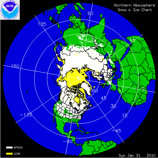
During the month of January, the U.S. experienced near–normal temperatures and slightly above–normal precipitation — see the national temperature and precipitation state of the climate report. These environmental conditions, as well as record snowfall during December 2009, were associated with above-normal snow cover extents across the contiguous U.S. and North America for the month. Snow cover extent during January 2010 ranked as sixth largest January extent since 1967 for North America and the United States. The North American monthly area snow extent was 18.20 million square km (7.0 million square miles), 713,000 square km (275,000 square miles) above the long–term average. Snow cover in the U.S. extented to 4.2 million square km (1.6 million square miles), 661,000 square km (232,000 square miles) above the long–term average. At the beginning of the month, snow was present for approximately 61 percent of the contiguous United States, including the Sierra Nevada Mountains, Cascade Mountains, Great Basin, Intermountain Rockies, northern and central Plains, the Great Lakes, Northeast, Mid-Atlantic, and Southern Appalachians. Winter storms during the month added to existing snow cover and increased snow cover extent across the country. At the end of January, 69.7 percent of the U.S. was under snow cover with the addition of the southern Plains, Tennessee River Valley, Ohio River Valley, and parts of the Southeast.


Arctic sea ice extent during the month of January was below normal. Most of the Arctic Ocean experienced cool temperatures during the month, except for the Atlantic sector where ice extent was unusually low. The Pacific side of the Bearing Sea had above–average ice extent. The Arctic ice extent averaged 13.78 million square km (5.32 million square miles), 1.09 million square km (417,000 square miles) below the 1979–2000 average for January. Arctic sea ice during January 2010 was 180,000 square km (69,000 square miles) greater than the record low for the month, which occurred in 2006. During the month, the sea ice extent grew at an average rate of 34,000 square km (13,000 square miles) per day, with ice growing faster at the beginning of the month compared to the end. This is significantly slower than the average January growth rate of 90,000 square km (35,000 squares) per day during the 1980’s. Please see the Arctic Sea ice analysis by the National Snow and Ice Data Center for additional information.

An intense low pressure system moving along the Northeast coast brought over two feet (61 cm) of snow to New England on January 2nd and 3rd. The suburbs of Boston received as much as 13 inches (33 cm) of snow accumulation. The National Weather Service Office in Burlington, Vermont measured 33.1 inches (84 cm) of snowfall for the event, marking the largest snowfall event recorded for the city. The previous heaviest snowfall occurred in December 1969, when the city received 29.8 inches (76 cm).

Satellite Image of West Coast Storm 20 January
Source: NASA
A series of strong Pacific storms impacted Arizona, California, Colorado, New Mexico, Nevada and Utah from January 17th through 23rd, leaving behind several feet of snow across the higher terrain and breaking numerous lowest barometric pressure records across the region. Sunrise Mountain, Arizona received 77 inches (196 cm) of snow, while Mammoth Lakes, California received 90 inches (229 cm) of snow. Apache Junction, Arizona had wind gusts in excess of 90 mph (145 km/hr). The storm also set all-time low pressure records over roughly 10-15 percent of the U.S., including the major cities of Los Angeles (983.3 mb), San Diego (987.0 mb), Salt Lake City (979.9 mb), Las Vegas (983.0 mb), and Phoenix (983.0 mb). Several of the stations breaking pressure records have data going back at least 140 years. El Niño events in the Pacific Ocean are typically accompanied by strong storms affecting the southwestern United States. Please see the CPC El Niño discussion for more details on ENSO conditions in the Pacific.

A large winter storm, bringing snow, sleet, and freezing rain paralyzed the Southern tier of the U.S. from January 27th through 30th. Wintry precipitation hit a string of states from New Mexico to New Jersey. Major interstates were forced to close, including large stretches of Interstate 40, an important east-west transportation artery for the country. Hundreds of thousands of people lost power due to impacts from the storm. Snowfall amounts greater than 10 inches (25 cm) were reported in New Mexico, Colorado, Kansas, North Carolina, Virginia, West Virginia, and Maryland. Freezing rain of over 1 inch (2.5 cm) was reported across Oklahoma and Texas, with many locations also receiving several inches of snowfall and sleet in addition to the ice.