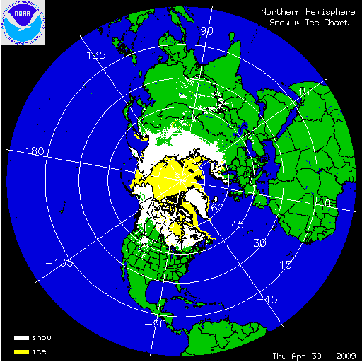

The Arctic sea ice reached its annual maximum extent on February 28, 2009, at 15.14 million square kilometers (5.85 million square miles). This is 720,000 square kilometers (278,000 square miles) below the 1979-2000 average of 15.86 million square kilometers (6.12 million square miles), marking the fifth-lowest maximum extent in the satellite record. The six lowest maximum extents have all occurred in the last six years (Source: National Snow and Ice Data Center). The Arctic sea ice reached its annual minimum extent on September 12, 2009, at 5.10 million square kilometers (1.97 millions square miles). This marks the third-lowest recorded extent since 1979, larger than the minimum extents of September 2007 and 2008. The 2009 minimum extent is 1.61 million square kilometers (620,000 square miles) below the 1979-2000 average minimum. The sea ice began its annual growth in Autumn, but at a slower rate compared to previous years. For the first weeks of November, the sea ice extent dropped below the 2007 record low extent, setting a new record for the month. However, by month's end the sea ice had grown above 2007 levels.
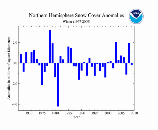
For the 2008-09 winter (Dec-Feb) the Northern Hemisphere experienced slightly below average snow cover, and had the 20th lowest snow cover extent on record. The 43-year mean Northern Hemisphere winter snow cover extent for the 1967-2009 period of record is 45.5 million square kilometers (17.6 million square miles).
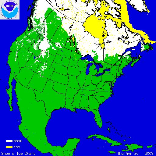
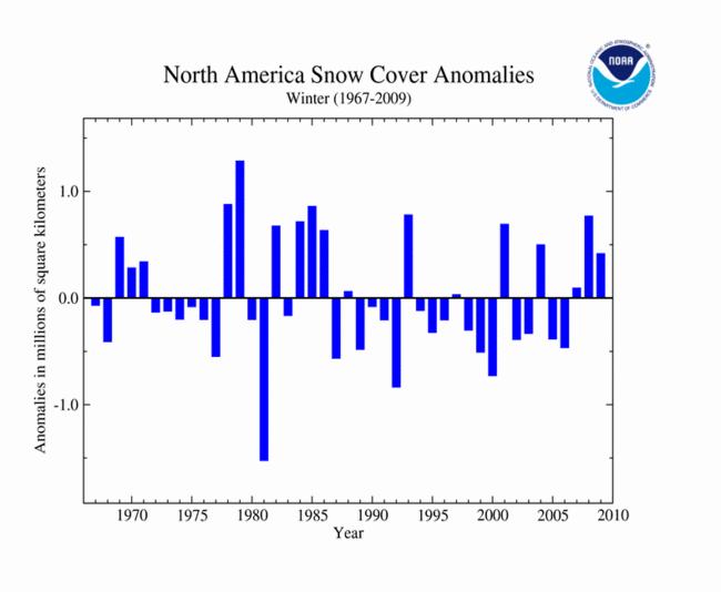
Across North America, snow cover for the 2008-09 winter was above average, with the 12th largest extent since satellite records began in 1967. The 43-year mean North America winter snow cover extent is 17.1 million square kilometers for the 1967-2009 period of record. A series of large snow and ice storms struck the U.S. during the winter months. The 2008-09 snow season brought numerous daily, monthly, and seasonal snowfall records across the contiguous United States.
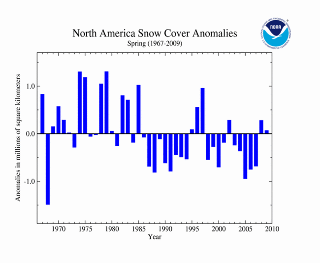
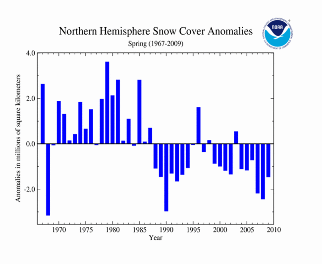
Snow cover extent during spring 2009 was the sixth-lowest spring snow cover extent on record. The 43-year average Northern Hemisphere spring snow cover extent for the 1967-2009 period of record is 30.8 million square kilometers (11.9 million square miles).
Across North America, snow cover for spring 2009 was the 17th largest extent since satellite records began in 1967. The average North America spring snow cover extent is 12.9 million square kilometers (5.0 millions square miles) for the 43-year period of record.
In 2009, the contiguous U.S. experienced nearly the same amount of snowfall for the month of October as the month of November. October 2009 ranked as the snowiest such period for the contiguous U.S. with 538,000 square kilometers (207,720 square miles) of snow cover extent, 385,000 square kilometers (148,650 square miles) above the long-term mean. The U.S. in November observed 585,000 square kilometers (225,870 square miles) of snow cover extent, 512,000 square kilometers (197,680 square miles) below the long-term mean. November 2009 ranked as the 6th smallest snow extent since the satellite record began in 1965. Cool temperatures in October and warm temperatures in November contributed to the snow cover extent anomalies across the contiguous United States.
Analysis provided by the Global Snow Laboratory, Rutgers University.
2008-2009
Significant Events
On December 11th 2008, southwest Louisiana and southeast Texas experienced a rare accumulating snowfall event. A cool upper level low pressure system interacted with rainfall lingering from a previous storm leading to the snow. Snowfall amounts up to six inches were reported in the region. On the following day in the Northeast, the same storm coated trees and wires with ice, causing an estimated 1.4 million customers to lose power. The damage from the storm was so severe that President Bush declared a state of emergency across much of the New England area.
On December 17th 2008, the mountains of Southern California received as much as 30 inches (76 cm) of snow while the Las Vegas, Nevada airport reported a new daily record of 3.6 inches (9 cm). It was the most snow for Las Vegas during any month since 7.5 inches (19 cm) fell in January 1979. More than 200 additional records were set on the 18th and 19th, when the same system moved northeast into the Great Plains. The snow totals from this system ranged from 6 to 10 inches (15 cm to 15 cm).
December 2008 snowfall broke historical monthly records in many locations across the Upper Midwest. La Crosse, Wisconsin had their snowiest December on record with 32.7 inches (83 cm) of snowfall. This also ranked as their fourth snowiest month on record. A December record of 45.6 inches (116 cm) of snow fell in Green Bay, Wisconsin, topping their previous record of 36.4 inches (92 cm) which was set in 1887. Madison, Wisconsin also experienced their snowiest December on record with 40.4 inches (103 cm). Grand Forks received a record 30.1 inches (76 cm) of snow for the month, which was also their second snowiest month on record. In Bismarck, North Dakota, the National Weather Service office recorded an all-time monthly snowfall record of 33.3 inches (85 cm). Fargo also recorded an all-time record snowfall amount for any month with 33.5 inches (85 cm).
In the northwestern U.S., Portland, Oregon experienced their snowiest December with 18.9 inches (48 cm) observed at the airport. This monthly total was their second snowiest month ever on record, bested only by the 41 inches (104 cm) that fell in January 1950. Spokane, Washington also set a December record with 46.2 inches (117 cm) of snow. The old record of 42.7 inches (108 cm) was set in 1996.
The Black Hills of South Dakota experienced a powerful blizzard on March 23rd through 24th. As much as 43 inches (109 cm) of snow fell in western South Dakota. The Rapid City airport received 11.5 inches (29 cm) of snow from the event. The airport also recorded consecutive record highs of 73°F and 77°F on the 21st and 22nd. Fargo, North Dakota received a record amount of snow for the month of March. The 28.1 inches (71 cm) shattered the previous record of 26.2 inches (67 cm) set in 1997. Just to the west, 29.7 inches (75 cm) at Bismarck tied with March 1950 for its highest amount of snow for March and its 5th highest amount for any month.
Another strong storm affected the middle of the country the last week of March, leaving heavy snow accumulations across the Southern Plains. The states of Texas, Oklahoma, and Kansas set new all-time 24-hour snowfall records during the blizzard on March 27th and 28th. A National Weather Service cooperative network observer in Follett, Texas reported a 24-hour snowfall total of 25 inches (64 cm). A cooperative observer in Kansas measured 30 inches (76 cm) in 24-hours in the town of Pratt. Two separate cooperative stations observed 26 inches (66 cm) of snowfall in 24-hours at Freedom and Woodward, Oklahoma, both breaking the previous 38 year-old record of 23.0 inches (58 cm). Snow drifts as high as 20 feet (6 meters) were reported across the Southern Plains.
During the 2008-09 winter season, several seasonal snowfall totals were noteworthy. International Falls, Minnesota, recorded 125 inches (318 cm) of snow, which broke a season snowfall record. The previous record of 116 inches (295 cm) was set during the 1995-96 season. The 97.7 inches (248 cm) of snow in Spokane, Washington, surpassed the previous record of 93.5 inches (238 cm) set in 1915-16. Bismarck, North Dakota received 100.3 inches (255 cm) of snow, only 1.3 inches (3 cm) shy of the record set during the 1996-97 season. The annual snowy trend continued in Youngstown, Ohio, which recorded 86.5 (220 cm) inches. Based on records that date back to 1948, the northeastern Ohio town has experienced its three snowiest seasons in the past three years (90.2 inches (229 cm) in 2006-07 and 102.8 inches (261 cm) in 2007-08).
The unusually cool and wet conditions experienced across the middle of the U.S. in October led to several locations setting snowfall records. Cheyenne, Wyoming experienced 28 inches (71 cm) of snow for the month, making October 2009 the city’s snowiest October on record. North Platte, Nebraska observed 30.3 inches (77 cm) of snowfall, making October 2009 the snowiest month of all months on record for the city. The previous record was 27.8 inches (71 cm) recorded in March 1912.