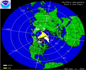
The two satellite-derived images above show the daily snow cover across the Northern Hemisphere (left map) and North America (right map) throughout October 2007. The maps show very small amounts of snow cover on October 1st, illustrating the beginning of the snow pack in the northern latitudes. By clicking on the images, the gradual expansion of snow and ice cover is shown to increase throughout the month across much of Siberia as well as parts of Alaska and Canada. Snow events in the U.S. are evident in the Rockies and the Sierras throughout the month of October, yet snow cover is short-lived.
More information on significant winter weather and other hazards can be found on NCDC's Hazards page.