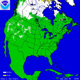
As can be seen in the animated image to the right, snow extent increased across North America during October, with anomalously sustained snow cover for the time of year in central and western Canada, and less than average snow cover for eastern Canada and southwestern Alaska. The first major snowfall of the season occurred for areas of the West as two large storms brought heavy snow to some western states, including California. Snow water content was also above average for basins in Wyoming, Montana and New Mexico at the end of October.

The graphs to the left show snow cover extent and departures from average for the contiguous US (top) and Alaska (bottom). Despite the advance of continental snow cover during October (as can be seen from the red line), snow cover extent was still below average for both Alaska and the contiguous US for the month (shown by the blue bars). Alaska had 51,000 km2 less snow cover than average, while the contiguous US had -92,000 km2 less than the mean. However, snow cover across Canada was greater than the October average leading to a positive anomaly of 550,000 km2 for the whole of North America.
(Averages are calculated based on data from Nov 1966 to present).

The image to the right shows a MODIS satellite image taken on October 31st from NASA's Terra satellite. Snow is visible on the Sierra Nevada Mountains of California following the second major storm in as many weeks to hit the state. Several feet of snow fell in some mountain locations and ski-resorts were able to open early.
See NCDC's snow climatology page for snow statistics for U.S. states and stations.