
The map to the right shows the percent average snowfall for the 2003-2004 winter season, as of the beginning of May. Below average seasonal snowfall generally occurred in the far eastern Mississippi Valley through the Tennessee Valley. Less than average seasonal snowfall was also evident in parts of the South, Colorado and western Kansas as well as patchy areas of the West. Above average snow amounts were recorded along much of the Appalachian chain, southwest Iowa, parts of the West and the northern Great Plains.
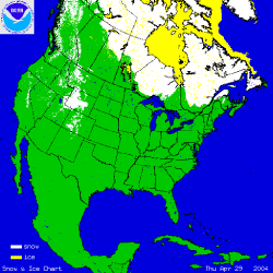
The map to the left shows snow cover on April 29th after a snow storm left 3-6 inches of snow across much of western Wyoming, with locally greater amounts in the higher elevations. When the map is Snow retreated rapidly and was below average across most of the West at the end of April, partly in response to a large ridge of high pressure and near record temperatures across much of the far West. At the beginning of May, snow and ice remained in the high regions of the Rockies and in eastern Canada. Hudson Bay was still frozen as of the end of April, though no significant ice remained across the Great Lakes.
See NCDC's snow monitoring page for the latest snow totals and the snow climatology pages for snow statistics for U.S. states and stations.