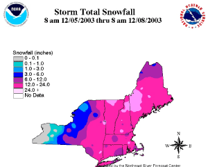
The map to the right shows snowfall totals in inches from a storm which tracked across the Northeast between December 5th and December 7th. The National Weather Service 24-hour snow totals and other information on the storm can be found at the Taunton, MA NWS office.
The image to the left shows the snow cover on December 30th 2003 after a series of snow storms left much the West covered in many feet of snow. Over 6 feet (2 meters) of snow fell on Utah's Salt Lake City leading to avalanches in the surrounding area and loss of electrical power for many residents.
A fast moving snow storm caused 150 miles of Interstate 5 through northern California/southern Oregon to be closed on December 28th and 29th. As much as 2 feet of snow fell along parts of the highway with drifts of 6-7 feet stranding motorists overnight with little food or water.
See NCDC's snow monitoring page for the latest snow totals and the snow climatology pages for snow statistics for U.S. states and stations.
 NOAA's National Centers for Environmental Information

