National Overview:

- Climate Highlights — July
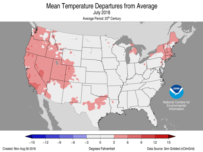 July Average Temperature Departures |
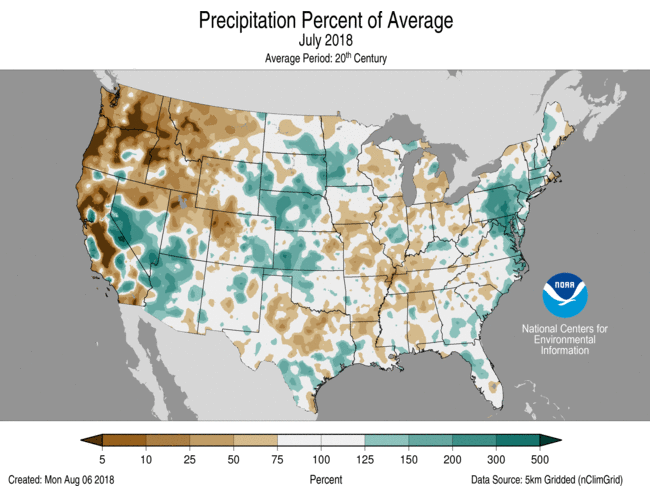 July Percent of Average Precipitation |
Temperature
- The July 2018 contiguous U.S. temperature was 75.5°F, 1.9°F above the 20th century average. This tied with 1998 as the 11th warmest July on record.
- Above-average July temperatures stretched from the West Coast to
the Rockies, through the South and into parts of the Northeast. Seventeen
states had July temperatures that were much-above-average, including California
which was record warm. The monthly average July temperature for Death Valley,
California, was 108.1°F, making it the hottest monthly temperature on
record for any station in the world, according to NCEI’s data holdings. This surpassed the record of 107.4°F set just last July in 2017 at Death Valley. - The warm and dry conditions across the West created ideal wildfire conditions. Numerous large and destructive fires burned across the region with many continuing to burn into August. These included, but were not limited to:
- The Spring Creek Fire in Colorado burned over 108,000 acres and destroyed 251 homes. This was the third largest wildfire on record for Colorado.
- The Carr Fire in California burned over 164,000 acres, destroyed more than 1,000 residences and was responsible for at least seven fatalities. This marks the sixth most destructive fire in terms of property loss on record for California.
- The Ferguson Fire in California burned over 94,300 acres, was responsible for at least two fatalities and forced the closure of parts of Yosemite National Park.
- The Mendocino Complex Fire in California burned over 283,800 acres and marked the largest wildfire on record for the state, surpassing the Thomas Fire that burned 281,000 acres in late 2017.
- Near- to below-average temperatures stretched from the Great Plains into parts of the Midwest and Southeast. In the central U.S., maximum temperatures, or afternoon highs, were particularly cool during July. Above-average precipitation in parts of the region contributed to the below-average temperatures.
- The Alaska July 2018 temperature tied with 2016 as the fifth highest since statewide records began in 1925. Parts of the Alaska Panhandle were record warm, including Juneau and Annette. Each of those locations also observed their warmest month of any month on record. Ketchikan had its second warmest July. The warm conditions contributed to a fish kill near Petersburg, Alaska.
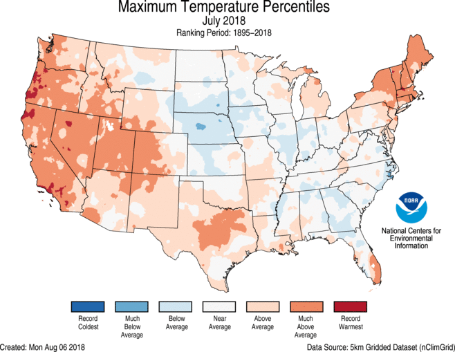
- The contiguous U.S. average maximum (daytime) temperature during July was 88.3°F, 1.6°F above the 20th century average, marking the 19th warmest value on record. Much-above-average maximum temperatures were observed across the West, Southern Plains and Northeast. Below-average maximum temperatures stretched form the Central and Northern Plains, through the Midwest and into parts of the Southeast.
- The contiguous U.S. average minimum (nighttime) temperature during July was 62.7°F, 2.2°F above the 20th century average, marking the eighth warmest value on record. Above-average minimum temperatures spanned the nation with record and much-above-average minimum temperatures across the West, South and northeast. California, Nevada and Utah had record warm July minimum temperatures. Near- to below-average minimum temperatures were observed in the Great Plains and parts of the Midwest and mid-Atlantic.
- During July there were 5,532 record warm daily high (1,945) and low (3,587) temperature records, which was more than five times the 943 record cold daily high (476) and low (467) temperature records.
- Based on NOAA's Residential Energy Demand Temperature Index (REDTI), the contiguous U.S. temperature-related energy demand during July was 87 percent above average and tied with July 1936 as the 10th highest value in the 124-year period of record.
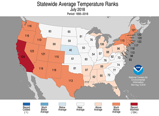
July 2018 Statewide Temperature Ranks
Precipitation
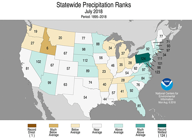
July 2018 Statewide Precipitation Ranks
- The July precipitation total for the contiguous U.S. was 2.80 inches, 0.02 inch above average, and ranked near the middle value in the 124-year period of record.
- Above-average precipitation was observed across parts of the Southwest, Great Plains and along the East Coast. In the Southwest, an active monsoon season brought heavy thunderstorms to the region. In the East, record and near-record precipitation was observed for much of Pennsylvania and parts of Maryland. Pennsylvania had its wettest July on record with 7.37 inches of precipitation, 3.18 inches above average. Maryland had its second wettest July with 8.73 inches, 4.55 inches above average.
- Below-average precipitation fell across much of the Northwest and in parts of the northern to central Rockies, Midwest and South. Idaho tied its sixth driest July on record with just 0.24 inch of precipitation, 0.59 inch below average. Much of Alaska was also drier than average, particularly the central regions and the panhandle.
- According to the July 31S. Drought Monitor report, 34.1 percent of the contiguous U.S. was in drought, up from 29.7 percent at the beginning of July. Drought conditions worsened in the Northwest, Central Rockies, Southern Plains, mid-Mississippi Valley and
Great Lakes. Drought improved in the Southwest, Northeast and parts of the
Central to Northern Plains. Outside of the contiguous U.S., drought worsened
for parts of Hawaii, but abnormally dry conditions improved for parts of southern Puerto Rico.
- Climate Highlights — year-to-date (January-July)
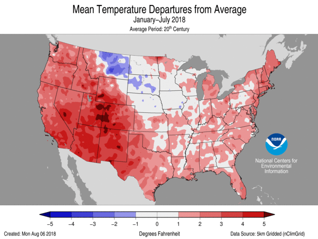 Jan-July Average Temperature Departures |
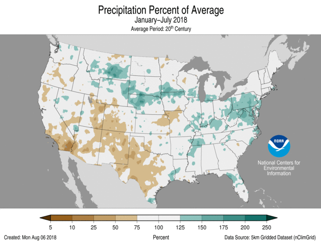 Jan-July Percent of Average Precipitation |
Temperature
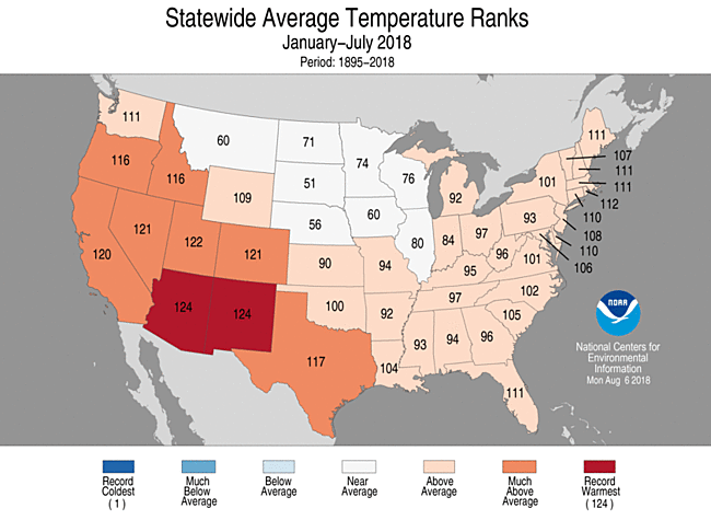
- For the year-to-date, the national temperature was 53.1°F, 1.9°F above average, also the 11th warmest on record. Of note, the last three month-period, May through July, ranked as the warmest such period on record with a national temperature of 70.9°F, 3.4°F above average. This surpassed the previous record of 70.6°F in 1934.
- Above-average January-July temperatures were observed across the West, Southern Plains, East Coast and much of the Midwest. Nine states in the West and South had much-above-average year-to-date temperatures, including Arizona and New Mexico which were record warm. The Arizona statewide average temperature was 62.7°F, 4.0°F above average, and the New Mexico temperature was 56.5°F, 3.9°F above average. Near- to below-average temperatures were observed in the north-central contiguous U.S.
- The Alaska statewide average temperature for the year-to-date was 29.9°F, 4.0°F above average, and tied 2014 as the sixth warmest on record. Above-average temperatures were observed across western and northern areas of the state, with near-average temperatures in southern Alaska.
- The contiguous U.S. average maximum (daytime) temperature during January-July was 65.2°F, 2.0°F above the 20th century average, marking the 11th warmest value on record. Much-above-average maximum temperatures were observed across the West, Southern Plains and parts of the Northeast. Arizona and New Mexico had record warm maximum temperatures. Below-average maximum temperatures stretched across the Northern Plains.
- The contiguous U.S. average minimum (nighttime) temperature during January-July was 41.1°F, 1.8°F above the 20th century average, marking the 15th warmest value on record. Above-average minimum temperatures were observed across much of the West and the East with near- to below-average conditions across parts of the Northern and Central Plains and the Upper Midwest.
- Based on NOAA's Residential Energy Demand Temperature Index (REDTI), the contiguous U.S. temperature-related energy demand during January-July was near average age and ranked near the median value in the 124-year period of record.
Jan-July Statewide Temperature Ranks
Precipitation
- The year-to-date precipitation total for the Lower 48 was 18.65 inches, 0.56 inch above average, and ranked near the middle value in the record.
- Above-average precipitation was observed in the Northern Plains, Midwest and along parts of the East Coast. Record precipitation was observed across parts of the mid-Atlantic, where Pennsylvania was record wet with 34.08 inches of precipitation, 9.01 inches above average. Six additional states in the East were also much wetter than average including Maryland and West Virginia which had their second wettest year-to-date.
- Below-average precipitation was observed for locations across the West and Southern to Central Plains. Colorado had its 12th driest year-to-date on record with 8.79 inches of precipitation, 2.38 inches below average.
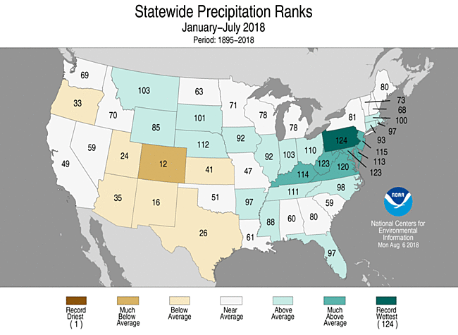
Jan-July Statewide Precipitation Ranks
Extremes
- The U.S. Climate Extremes Index (USCEI) for the year-to-date was 30 percent above average and ranked as the 20th highest value in the 109-year period of record. This was the smallest January-July USCEI since 2013. On the national scale, extremes in warm minimum and maximum temperatures and one-day precipitation totals were much above average.
- On the regional scale, the Southwest had a record high CEI value for the year-to-date due to elevated extremes in warm maximum and minimum temperatures, the spatial extent of dry conditions and one-day precipitation totals.
Regional Highlights:
These regional summaries were provided by the six Regional Climate Centers and reflect conditions in their respective regions. These six regions differ spatially from the nine climatic regions of the National Centers for Environmental Information.
- Northeast Region: (Information provided by the Northeast Regional Climate Center)
- The average temperature for the Northeast for the month of July was 71.7 degrees F (22.1 degrees C), ranking this as the 14th warmest July on record for the region, with a departure of 2.1 degrees F (1.2 degrees C) above normal. Each state in the region experienced average temperatures that were above normal for July. Eight of the twelve states in the Northeast ranked this July among their 20 warmest on record: Maine, fourth warmest; Massachusetts, New Hampshire, and Vermont, fifth warmest; Rhode Island, eighth warmest; Connecticut, ninth warmest; New York, 10th warmest; and New Jersey, 16th warmest. Temperature departures from normal ranged from 0.3 degrees F (0.2 degrees C) above normal in Maryland to 3.1 degrees F (1.7 degrees C) above normal in Maine, New Hampshire, Vermont, and Massachusetts.
- Precipitation varied greatly throughout the region during the month of July. The Northeast received 5.44 inches (138.2 mm) of precipitation on average, which made this the 11th wettest July on record for the region. Pennsylvania received 7.37 inches of rain, which was 173 percent of normal, ranking this as their wettest July on record. Maryland experienced its second wettest July on record and received 8.73 inches (221.7 mm) of precipitation. Connecticut ranked this as their 14th wettest July after receiving 135 percent of normal precipitation. Three states in the region experienced a drier-than-normal July, including Maine, Vermont, and Rhode Island. Precipitation departures from normal ranged from 1.32 inches (33.5 mm) below normal in Rhode Island to 4.58 inches (116.3 mm) above normal in Maryland.
- At the beginning of the month, 25 percent of the Northeast was abnormally dry, which included central New York and New England. Moderate drought was impacting six percent of the region in southern Vermont, New Hampshire, and Maine. By the middle of July, 12 percent of the Northeast was experiencing moderate drought conditions. During that time, 30 percent of the region was abnormally dry, and abnormal dryness spread briefly into southern New Jersey and part of the Mid Atlantic. Compared to the beginning of the month, conditions improved by the end of July, when 18 percent of the entire Northeast was abnormally dry and nine percent of the region was in moderate drought.
- A heat wave impacted the Northeast at the beginning of July and heavy rain during the second half of the month led to significant flooding in the southern part of the region. From July 1 through July 4, high humidity along with unusually warm temperatures throughout the region, resulted in heat indices over 110 degrees F (43.3 degrees C) in some areas, prompting Excessive Heat Warnings to be issued by the National Weather Service. Daily high temperature records were set at numerous locations throughout New York, Vermont, and Maine. Burlington, Vermont experienced its warmest three-day stretch on record from June 30 through July 2. Two heat-related deaths were reported in New York, along with one in Pennsylvania. On July 10, severe weather produced hail up to one inch in diameter in Maine, denting cars and windows. Wind damage and fallen trees were also reported that day in parts of Maine and New Hampshire. An EF-0 tornado touched down briefly in Windham County, Connecticut on July 17 with winds up to 85 mph (40 m/s), uprooting numerous trees. Severe weather moved through Massachusetts on that same day and caused lightning strikes that resulted in three house fires. Heavy rain during the second half of the month led to flooding in many states in the southern part of the region in particular. Dulles Airport, Virginia received 5.02 inches (127.5 mm) of rain on July 21. Dunkirk, Maryland received 16.55 inches (420.4 mm) of rain over the span of five days, ending on July 26. After receiving no measureable precipitation during the entire first half of the month, heavy rain from July 23 through July 27 caused some creeks and streams to rise up to seven feet (2.1 m) in an hour, which led to flooding in parts of Washington, DC. More than a dozen water rescues were needed during those few days in that area. On July 24, many parts of New England received heavy rain, with much of western Massachusetts receiving over three inches (76.2 mm) of rain, which led to minor street flooding in some areas. Locations along Swatara Creek in Pennsylvania experienced significant flooding that led to home evacuations as a result of the swiftly moving water rising to 17 feet (5.2 m), which is 15 feet (4.6 m) above its usual height. In parts of northern New England, many farmers have been impacted by dry conditions. Reduced harvests and heat stress are both causing problems for growers as moderately dry conditions continue to impact New Hampshire, Vermont, and Maine.
- For more information, please go to the Northeast Regional Climate Center Home Page.
- Midwest Region: (Information provided by the Midwest Regional Climate Center)
- Precipitation was below normal in July across most of the Midwest. Regionwide, 3.24 inches (82 mm) fell, which was 80 percent of normal and ranked 36th driest on record (1895-2018). Minnesota (106 percent of normal) was the only state in the region with above normal precipitation. Every other state except Kentucky (93 percent of normal) and Missouri (57 percent of normal) had between 70 and 80 percent the normal amount. Missouri's 2.42 inches (61 mm) in July ranked as the 23rd driest on record. The Chicago-O'Hare Airport had its driest July in its 60-year period of record (1959-2018).
- A hot first half of July and a cooler second half led to slightly warmer than normal temperatures across the region. Average temperatures for July were 73.4°F (23.0°C) which was 0.8°F (0.6°C) above normal. During the warm first half of the month, very warm overnight minimum temperatures played a large role, while very cool maximum temperatures played a similar role during the cool second half. More than 250 daily high minimum and 150 daily low maximum records were either broken or tied during the month as a result.
- July was an active month of severe weather in the Midwest, with more than 950 reports of tornadoes, strong thunderstorm winds, or large hail. Nearly 400 of these reports occurred on July 19-20. Thirteen tornadoes impacted Iowa on July 19, with two of them rated EF-3. Extensive damage was reported in Marshalltown, IA from one of these EF-3 tornadoes, as it tracked directly through the town. Zero fatalities and only six injuries were reported from the 13 confirmed tornadoes. In Missouri, strong winds on July 19 caused a duck boat to capsize near Branson, killing 17 people. Strong winds and hail impacted central Kentucky on July 20. A four-inch diameter hailstone was reported near Tompkinsville, KY, one of the largest ever recorded in Kentucky.
- Regionwide, abnormally dry conditions and drought more than doubled in July. Drought significantly worsened in Missouri during the month. In the July 3 U.S. Drought Monitor, 17 percent of Missouri was in Severe Drought. By the July 31 U.S. Drought Monitor, more than 32 percent of the state was in Severe Drought, with more than 17 percent in Extreme Drought. Agriculture was severely impacted, as cattle were being sold due to lack of feed, while crops were being abandoned. Meanwhile, flash drought rapidly developed in Michigan. Less than ten percent of the state was considered abnormally dry at the beginning of the month. By the end of the month, more than a quarter of the state in moderate drought with nearly 70 percent of the state abnormally dry.
- For further details on the weather and climate events in the Midwest, see the weekly and monthly reports at the Midwest Climate Watch page.
- Southeast Region: (Information provided by the Southeast Regional Climate Center)
- Temperatures during July were near average (i.e. within 2 degree F (1.1 degrees C)) across most of the Southeast region, including Puerto Rico and the U.S. Virgin Islands. Temperatures, were extraordinarily warm in South Florida as several long-term stations observed monthly mean temperatures that were ranked within their five warmest values on record, including Key West, FL (1871-2018; first warmest) and Melbourne, FL (1937-2018; third warmest). Daily minimum temperatures were above average across much of the region. Eight long-term stations in Florida and Georgia observed average daily minimum temperatures that were ranked within their five warmest values on record, including Gainesville, FL (1890-2018; first warmest). On the 11th, sinking air motions between Hurricane Chris, situated off of the East Coast, and an upper-level ridge across the interior U.S produced the warmest weather of the month. The maximum temperature in Columbia, SC soared to 103 degrees F (39.3 C), which was the warmest temperature observed across the region during the month. In contrast, the coolest weather of the month occurred on the 8th and 9th, as an unseasonably strong, continental high pressure system ushered in cooler and drier air from Canada. Daily minimum temperatures ranged from 46 to 59 degrees F (7.8 to 15.0 degrees C) across most of Virginia and the western two-thirds of North Carolina. Mustoe 1 SW, VA (1994-2018) which lies in an elevated (2367 feet) valley, recorded a daily record minimum temperature of 43 degrees F (6.1 degrees C).
- Precipitation was highly variable across the Southeast region during the month, which is common during the summer. Monthly precipitation totals were 50 to 25 percent of normal across local areas of Alabama, portions of Georgia, and the central and western portions of Virginia and the Carolinas. Waynesville 1 E, NC (1894-2018) observed its fifth driest July on record, with only 1.72 inches (43.7 mm) of precipitation. In contrast, the wettest locations were found across portions of eastern Virginia, coastal areas of the Carolinas, northcentral Florida and local areas across the reminder of the region. Monthly precipitation totals were 150 to more than 300 percent of normal in these areas. Eleven long-term stations observed precipitation totals that were ranked within their five highest values on record. Most outstanding was Cape Hatteras, NC (18.74-2018), which observed it wettest July and second wettest all-time month with 20.31 inches (515.9 mm). Wilmington, NC (1871-2018) observed its fourth wettest July and its ninth wettest month on record, with 17.10 inches (434.3 mm) of precipitation. Washington Dulles Airport, VA (1962-2018) recorded its wettest July and 4th wettest month with 11.21 inches (284.7). As is typical of July, localized heavy rainfall produced flash flooding across small portions of the region. On the 6th, Tuscaloosa, AL (1948-2018) observed its wettest July day, with 4.39 inches (111.5 mm) of precipitation. Most of the precipitation fell in a single hour, overwhelming the city's drainage system and producing street flooding. On the 20th and 21st, heavy rainfall was observed across portions of the coastal Carolinas and eastern Virginia, as an unseasonably strong upper level low, diving into the Southeast, generated a surface low pressure that advanced northward across the region. Washington Dulles Airport observed its fifth wettest day for any month on record, with 5.02 inches (127.5 mm) of precipitation. Over the next three days (23nd to 25th) the upper level low slowly weakened and drifted westward, forcing a plume of extraordinarily moist tropical moisture northward across eastern portions of the Southeast. Nearly 9 inches of rain fell at Cape Hatteras over this three-day period. This amount contributed nearly half of the extraordinary July total precipitation and resulted in much street flooding.
- There were 537 severe weather reports across the Southeast during July, which is nearly 91 percent of the median monthly frequency of 591 reports during 2000-2017. At least one severe weather report was recorded on 29 days during the month, and there were two days (21st and 22nd) with over 200 reports. About 85 percent (459 of 537) of the severe weather reports during the month were for strong thunderstorm winds, and nearly half (242 of 459) of these reports occurred in Georgia and North Carolina. Some of the highest thunderstorm wind gusts that were recorded included 65 mph at Charlotte Douglas Airport in Charlotte, NC, 57 mph & 51 mph at Wilmington International Airport in Wilmington, NC, 52 mph at Charlottesville Albemarle Airport in Charlottesville, VA. Thunderstorm winds were responsible for 2 fatalities and 3 injuries in Florida and North Carolina, with most of these casualties caused by falling trees. On the 5th, straight line thunderstorm winds knocked over trees onto a car, killing 1 and injuring 2, near the Green Mountain Recreational Park in Lenoir, NC. On the 22nd, strong thunderstorm winds caused a tree to fall onto two men unloading furniture just north of Daytona Beach, Fl, killing a 56-year-man. Though there were 68 hail reports across the region in July, only a few reports stood out based on the size of the hail stone reported. On the 22nd, tennis ball-sized hail (4.00-inch diameter) was reported in Covington County, Alabama. On the 21st 3.00-inch diameter hail was reported in Cleburne County, Alabama, and 2.50-inch diameter hail was reported in Gwinnett County, Georgia. Only 7 tornadoes (6 EF-0, 1 EF-1) were confirmed across the region during the month, which is shy of the median frequency of 10 tornadoes observed during July. On the 27th, an EF-1 tornado tracked 2.35 miles across Chatham County near Savannah, GA. Powerlines were downed and over 100 large trees were snapped and uprooted along the path. The roof of a log cabin blew off and partially damaged another structure on Oatland Island, while an elementary school sustained severe roof damage. Lightning resulted in two fatalities during the month. On July 4th a Dalton, GA man was fishing with his kids when he was struck and killed. On July 10th, a 39 year old West Palm Beach, FL man was killed when three bolts hit near where he was cutting branches.
- Drought conditions (D1 and greater) were not observed across the Southeast region for the second consecutive month, though small pockets of abnormal dryness (D0) persisted across the interior Carolinas. In addition, a swath of abnormally dry conditions remained across southern Puerto Rico during the month. Farmers in the some of the wetter areas of the region experienced a variety of problems, especially where wet conditions were also observed in June. In portions of southern Georgia, the unrelenting wetness continued to encourage a host of crop diseases. Gummy Stem Blight, for example, impacted watermelons, forcing growers to carry out aggressive fungicide treatments. Blueberry farmers in Georgia lost about 60 percent of their crops this year due to the combined effects of very wet conditions in June and July and an early spring freeze. The heavy rainfall across portions of coastal North Carolina and Virginia flooded agricultural fields, which submerged and drowned various crops.
- For more information, please go to the Southeast Regional Climate Center Home Page.
- High Plains Region: (Information provided by the High Plains Regional Climate Center )
- Temperature and precipitation patterns varied across the High Plains in July, and the presence of extremes was no exception this month. Much of the region experienced relief from the heat, particularly in the eastern High Plains where temperatures were slightly below normal. In fact, the second half of July brought fall-like temperatures to areas of the Dakotas, Nebraska, and Kansas. However, the extreme heat continued in the western High Plains, providing no relief to drought-stricken areas of Colorado and southern Wyoming. Heavy rains provided drought relief to southwestern Kansas and portions of the Dakotas, but it also caused flooding in locations such as Brookings, South Dakota. Severe weather was a prominent feature throughout the High Plains in July, as tornadoes, hail, and high winds damaged crops and structures. Meanwhile, eastern Kansas, western Colorado, and southern Wyoming missed out on the rains, and drought impacts continued to mount. Streamflows were indicative of heavy rainfall or the lack thereof throughout the region, with high flows in portions of South Dakota and Nebraska, and low flows in areas of Colorado, Wyoming, and Kansas.
- July marked the approximate halfway point through the growing season and, for the most part, crops were faring well. Kansas was the exception where nearly one-quarter of the corn and soybean crops were in poor to very poor condition, according to the July 31st U.S. Department of Agriculture's Weekly Weather and Crop Bulletin. Corn progress was well ahead of schedule due to the heat experienced during the late spring and early summer, and it is expected to mature early across much of the region this year. The winter wheat harvest was nearly wrapped up in Colorado and Kansas, and production was negatively impacted by a combination of drought and hailstorms. Pastureland was suffering in the two states, with 46 percent of pastureland in Colorado and 35 percent of pastureland in Kansas in poor to very poor condition. Throughout the course of the month, topsoil moisture declined in all High Plains states except Colorado. However, it was still faring worst in Colorado, with 35 percent of the state's topsoil moisture rated poor to very poor.
- The warm pattern that began in May finally broke for much of the High Plains in July, with the majority of the region experiencing near normal to slightly below normal temperatures for the month. The exception was western Colorado and southern Wyoming, where above-normal temperatures prevailed. Departures in this region ranged from 3.0-5.0 degrees F (1.7-2.8 degrees C) above normal. Grand Junction, Colorado tied 1934 for its 2nd warmest July on record with a temperature departure of 4.3 degrees F (2.4 degrees C) above normal. Maximum daily temperatures were at or above 92.0 degrees F (33.3 degrees C) the entire month at this location, and the daily average temperature departure was above normal every day except July 1st.
- July started out quite warm, and the 4th of July was no exception. High heat and humidity prompted the issuance of heat advisories for portions of the region. The period from July 7th-11th was particularly warm, as numerous daily maximum temperature records were broken. However, eastern portions of the High Plains saw relief from the heat and humidity during the latter half of the month.
- Despite more seasonable temperatures in corn-producing areas of the region, the extreme warmth during the late spring and early part of the summer caused corn to progress more quickly than normal. The accumulation of corn Growing Degree Days, a way to estimate corn crop progress based on temperature, was well ahead of normal in July, which is an indication that the crop is expected to mature early. A positive outcome of an early maturing corn crop is a lower risk for damage from early fall frosts.
- Precipitation extremes on both sides of the spectrum occurred in the High Plains during July. Excessively wet conditions could be found throughout northern and western Nebraska, southern Kansas, and pockets of the Dakotas. Heavy rains caused flooding in some areas, but were welcomed in others that were suffering from drought. Locations with a top 10 wettest July on record included Brookings 2NE (COOP), SD (2nd wettest), Rapid City, SD (2nd wettest), McCook, NE (9th wettest), and Valentine, NE (9th wettest). Other areas missed out on heavy rains in July. Precipitation was less than 50 percent of normal in western Wyoming, western Colorado, and eastern Kansas, causing drought to spread and intensify across these areas. Topeka, Kansas had its 5th driest July on record, while Grand Junction, Colorado tied for its 9th driest.
- Severe weather ravaged the High Plains during July, with flooding, hail, tornadoes, and high winds causing damage to crops and structures. On the 10th, a tornado struck an RV park in the middle of the night in Watford City, North Dakota, killing one person and injuring 28 others. Rated an EF2 on the Enhanced Fujita Scale, the tornado was estimated to have winds of 127 miles per hour (204 km/hr) and destroyed 122 trailers, manufactured homes, and other structures, according to the National Weather Service in Bismarck.
- On the 19th, torrential rains fell in Brookings, South Dakota, causing power outages and basements to flood. An astounding 6.83 inches (173 mm) of rain was recorded at Brookings 2NE (COOP), which was the highest 1-day total precipitation ever recorded in any month for this location (period of record 1893-2018). This crushed the previous record of 5.54 inches (141 mm) set on June 25, 1980.
- Numerous hailstorms damaged crops and structures throughout the High Plains in July. On the 8th, hail shredded tasseled corn, soybeans, and alfalfa in Oakes, North Dakota. During the last week of July, large hail pummeled portions of Colorado, Wyoming, and South Dakota. Corn was destroyed by baseball-sized hail in Granada, Colorado. According to local producers, widespread crop damage in northern and eastern portions of the state is expected to be costly. Just south of Cheyenne, Wyoming, hail accumulated to three inches deep, causing traffic issues on Interstate 25.
- Streamflows varied across the region during July. According to the U.S. Geological Survey, streamflows were much above normal in western and southeastern South Dakota, as well as northern and central Nebraska. These areas were quite wet in July, receiving 150-300 percent of normal precipitation. Due to above-normal snowpack and heavy spring rains in the Upper Missouri River Basin, the U.S. Army Corps of Engineers continued higher-than-average releases from all Missouri River Mainstem projects in July. However, releases from Garrison Dam were reduced during the latter part of the month as they continued to evacuate stored floodwaters. Meanwhile, streamflows were much below normal in areas of the High Plains where drought has persisted, including eastern Kansas, southern and western Colorado, and southern Wyoming.
- Several improvements and degradations in drought conditions occurred during the past month across the High Plains, according to the U.S. Drought Monitor. Overall, the area experiencing drought or abnormally dry conditions (D0-D4) decreased from 45 percent to 38 percent in the region. Conditions continued to improve in many areas of the Dakotas. Near normal to slightly below normal temperatures and pockets of heavy rainfall allowed for the removal of severe drought (D2) in both states, as well as a reduction in moderate drought (D1) and abnormally dry conditions (D0). Areas of southwestern Kansas and southeastern Colorado received some relief as well, resulting in a one-category reduction in drought severity in southeastern Colorado and the removal of drought in southwestern Kansas.
- Areas in drought that missed out on beneficial precipitation saw a deterioration of conditions. While temperatures were mostly normal to slightly below normal in the region for the month, it was quite warm across southern Wyoming and western Colorado, with departures of 3.0-5.0 degrees F (1.7-2.8 degrees C) above normal. Combined with persistent dryness, drought spread and intensified across this region. In western Colorado, wildfires continued to burn, and the recreation and tourism industry experienced revenue loss. Conditions also worsened in eastern Kansas where it was warmer and drier than normal. The Governor of Kansas expanded the number of counties in a drought emergency to 50, and 43 counties were authorized for emergency haying and grazing of Conservation Reserve Program lands.
- For more information, please go to the High Plains Regional Climate Center Home Page.
- Southern Region: (Information provided by the Southern Regional Climate Center)
- Temperatures for the month of July varied spatially throughout the Southern Region. Parts of extreme northwestern Oklahoma, western Mississippi, and southern Texas experienced temperatures 1 to 2 degrees F (0.56 to 1.11 degrees C) below normal. Most of Texas, southern and eastern Oklahoma, northern, central, and southern Arkansas, northern and southeastern Louisiana, northern and southern Mississippi, and southwestern and northeastern Tennessee experienced temperatures 1 to 3 degrees F (0.56 to 1.67 degrees C) above normal. Central, eastern, northeastern, and extreme western Texas, northern and southeastern Louisiana, areas in northwestern, southwestern, and northeastern Arkansas, and an area in northeastern Mississippi experienced 3 to 5 degrees F (1.67 to 2.78 degrees C) above normal temperatures. The statewide monthly average temperatures were as follows: Arkansas – 81.60 degrees F (27.56 degrees C), Louisiana – 83.40 degrees F (28.56 degrees C), Mississippi – 81.80 degrees F (27.67 degrees C), Oklahoma – 82.70 degrees F (28.17 degrees C), Tennessee – 78.10 degrees F (25.61 degrees C), and Texas – 84.40 degrees F (29.11 degrees C). The statewide temperature rankings for July were as follows: Arkansas (twenty-eighth warmest), Louisiana (fourteenth warmest), Mississippi (thirty-third warmest), Oklahoma (forty-fourth warmest), Tennessee (thirty-sixth warmest), and Texas (twelfth warmest). July was the third consecutive month where temperatures were above normal throughout the Southern Region. All state rankings are based on the period spanning 1895-2018.
- Precipitation values for the month of July varied spatially throughout the Southern Region. Parts of western, southern, and central Texas received 5 percent or less of normal precipitation. Northern, northeastern, southern, western, and central Texas, northern and eastern Louisiana, northeastern, eastern, and southern Arkansas, northwestern, western, and southern Tennessee, and areas in northern and southwestern Mississippi received 50 percent or less of normal precipitation. In contrast, parts of western, southwestern, southern, and eastern Texas, western, northern, and southeastern Oklahoma, western, southern, and extreme southeastern Louisiana, western Arkansas, northwestern and southern Mississippi, and an area in southeastern Tennessee received 150 percent or more of normal precipitation. The state-wide precipitation totals for the month were as follows: Arkansas – 3.00 inches (76.20 mm), Louisiana – 4.90 inches (124.46 mm), Mississippi – 4.61 inches (117.09 mm), Oklahoma – 3.14 inches (79.76 mm), Tennessee – 3.46 inches (87.88 mm), and Texas – 2.18 inches (55.37 mm). The state precipitation rankings for the month were as follows: Arkansas (fortieth driest), Louisiana (forty-fourth driest), Mississippi (fifty-seventh driest), Oklahoma (fifty-first wettest), Tennessee (twenty-eighth driest), and Texas (fifty-fourth driest). All state rankings are based on the period spanning 1895-2018.
- At the end of July and into August, extreme drought classifications are still present in southwestern, extreme northwestern, and southeastern Oklahoma, southwestern, northern, central, and eastern Texas, and northwestern Louisiana. Severe drought classifications are present throughout parts of northern, central, southwestern, and northeastern Texas, southwestern, southeastern, northwestern, and northeastern Oklahoma, southwestern Arkansas, and northwestern Louisiana. Moderate drought classification is present throughout parts of central, southern, and eastern Texas, western, southern, and northeastern Oklahoma, most of Arkansas, eastern and northwestern Louisiana, northwestern Tennessee, and a part of southwestern Mississippi.
- In July, there were severe storm reports everyday throughout the Southern Region except on July 9, July 21, and July 26.
- On July 1, 2018, a microburst with a 75 mph (120.70 kph) windspeed was reported near Chico, Texas.
- On July 2, 2018, a wind gust of 71 mph (114.26 kph) was reported near Seagraves, Texas.
- On July 3, 2018, a wind gust of 66 mph (106.22 kph) was reported near Texarkana, Arkansas.
- On July 4, 2018, a landspout tornado was reported near Hutto, Texas. A fatality was reported in Pickwick Landing State Park, Tennessee, when a wind gust blew a tree onto a car, fatally injuring the occupant.
- On July 6, 2018, there were 59 wind reports throughout the Southern Region states. A wind gust of 67 mph (107.83 kph) was reported near Monroe, Louisiana. Two houses reported major roof damage near Limestone, Texas.
- On July 13, 2018, a wind gust of 82 mph (131.97 kph) was reported at the El Paso International Airport, Texas.
- On July 14, 2018, a wind gust of 69 mph (111.05 kph) was reported near Pampa, Texas.
- On July 15, 2018, a wind gust of 70 mph (112.65 kph) was reported near Claude, Texas.
- On July 16, 2018, there were 14 wind reports between Tennessee, Arkansas, and Mississippi.
- On July 19, 2018, a wind gust of 74 mph (119.09 kph) was reported near Metcalfe, Mississippi.
- On July 20, 2018, there were 112 wind reports between Tennessee, Arkansas, and Mississippi, and there were 27 hail reports between Arkansas, Tennessee, and Oklahoma. Four injuries were reported near Mull, Arkansas, when trees were blown down onto RV campers at Buffalo Point. Baseball sized hail was observed near Elkins, Arkansas. A wind gust of 85 mph (136.79 kph) was reported near Drew, Mississippi. Damage consistent with straight-line winds between 75-80 mph (120.70 – 128.75 kph) was reported in Atkins, Arkansas.
- On July 22, 2018, a wind gust of 70 mph (112.65 kph) was reported near Kenton, Oklahoma.
- On July 28, 2018, wind gusts between 60 – 70 mph (96.56 – 112.65 kph) were reported in Kremlin and Cromwell, Oklahoma.
- On July 31, 2018, tennis ball sized hail was reported near Newton, Mississippi. Also, a wind gust of 63 mph (101.39 kph) was reported in Pine Springs, Texas.
- For more information, please go to the Southern Regional Climate Center Home Page.
- Western Region: (Information provided by the Western Region Climate Center)
- Above normal temperatures were observed across much of the West this month, with several California and Nevada locations setting significant temperature records. Monsoon activity brought above normal precipitation to the Southwest, while the Northwest and most of California remained dry, typical of July.
- Anomalous high pressure over the West this month led to well above normal temperatures across much of the region. In southern California, Los Angeles reported its 3rd warmest July since records began in 1877 at 78.8 F (26 C), 5.5 F (3 C) above normal. Further north in California's Central Valley, Fresno set a record for all-time hottest calendar month at 88.2 F (31.2 C), 5.2 F (2.9 C) above normal. Records for Fresno began in 1949. Across the Sierra Nevada, the average July temperature at Reno, Nevada, was 81.8 F (27.7 C), 6.9 F (3.8 C) above normal, and set the record (beating out July 2017) for the warmest of any calendar month since records began in 1937. There were 14 days where the daily maximum temperature was greater than or equal to 100 F (37.8 C), setting a record for most such days in a month. On the eastern side of Nevada, Elko observed its all-time hottest month as well at an average 77.2 F (25.1 C), 7 F (3.9 C) above normal. Records for Elko began in 1890. The Pacific Northwest experienced significant temperature anomalies as well. Portland, Oregon, recorded its second warmest calendar month in an 81-year record at 74 F (23.3 C), 4.8 F (2.7 C) above normal.
- Many areas typically influenced by the North American Monsoon experienced near to above normal precipitation in July. Western Arizona, the southern portions of Utah and Nevada, and the eastern Sierra Nevada observed well above normal precipitation. Bishop, California, reported its wettest July in a 124-year record at 1.52 in (39 mm), 950% of normal. Further south, in western Arizona, Wikieup recorded 2.51 in (64 mm) for July, 482% of normal and the 4th wettest since records began in 1925. Some improvement in drought conditions was observed in Arizona and New Mexico in the US Drought Monitor this month due to the monsoon rains. Drought expansion occurred in portions of the Pacific Northwest due to short-term hot and dry conditions combined with dryness during much of the winter and spring seasons.
- Nearly all of Alaska observed warmer than normal temperatures in July, especially the Southeast. Juneau recorded its warmest July and warmest calendar month on record at an average temperature of 61.2 F (16.2 C), 4.3 F (4.3 C) above normal. The Panhandle was also unusually dry; Ketchikan logged its third driest July at 1.21 in (31 mm), 18% of normal. The dry weather extended into the Southeast mainland where Gulkana recorded 0.67 in (17 mm), 37% of normal. Above normal ocean temperatures were present this month in the Bering Sea, related in part to the unprecedented low sea ice during the past winter and spring. Reports have included incidences of dead Pollock washing ashore and unusually high mortality of sea birds and seal pups.
- July is typically one of the driest months of the year across much of Hawaii. Most locations observed drier than normal conditions for July. For example, Honolulu reported 0.23 in (6 mm), 45% of normal. However, a few locations recorded above normal precipitation including Kona, on the Big Island, which observed 1.25 in (32 mm) of precipitation, 178% of normal.
- All Month: Wildfire impacts across the West: Many large and impactful fires occurred in the West this month. Persistent well above normal temperatures and dry fuels have made firefighting efforts challenging in some areas. Smoke from the fires has reduced air quality throughout large areas of the West, with notable impacts in central and northern California, western Nevada, and southern Oregon. The most destructive fire has been the Carr Fire in northern California. It was ignited on July 23 due to mechanical failure of a vehicle and has since burned over 120,000 acres (48,500 ha) and destroyed over 1000 residences. The Ferguson Fire in the central Sierra Nevada has burned over 70,000 acres (28,000 ha) and prompted the evacuation and temporary closure of Yosemite National Park, a popular summer tourist destination. The Goose Creek Fire, at the Nevada-Utah state line, was ignited by lightning on July 26 and has burned over 120,000 acres (48,500 ha). In southwestern Oregon, the Taylor Creek Fire was started by lightning on July 15 and has burned over 30,000 acres (12,000 ha). By the end of July, the Washington State Department of Natural Resources had responded to over 900 fires in 2018, compared to 853 in all of 2017. However, most of these fires were contained while relatively small.
- Mid-month: Monsoon-related flash flooding in Southwest: High intensity rainfall associated with monsoon thunderstorms caused destructive flash flooding and mass movements. Flash floods damaged homes and farmland in central and southern Utah as well as initiated damaging mud and debris flows. On July 13th, thunderstorms resulted in debris flows and derailing of a freight train, leading to multiple hours of road closure on US Highway 95 near the California-Nevada border. Persistent heavy rainfall mid-month in Flagstaff, Arizona, resulted in flash flooding and difficult travel conditions including flooded roadways and road closures. Roughly 20 homes were damaged by flash floods on July 15 in the small town of San Antonio, New Mexico.
- For more information, please go to the Western Regional Climate Center Home Page.