National Overview:

- Climate Highlights — November
 November Average Temperature Departures |
 November Percent of Average Precipitation |
Temperature
- The contiguous U.S. average November temperature was 48.0°F, which was 6.3°F above the 20th century average. This was the second warmest November in the 122-year period of record, behind November 1999 (48.1°F).
- Every state in the Lower 48 experienced an average temperature that was at least above average. Idaho, North Dakota and Washington were record warm in November. North Dakota's average temperature was 12.8°F above normal, nearly 2.0°F above the previous record set in 1999. Near-record warmth blanketed the western half of the country where 15 states had their second or third warmest November. Alaska was slightly above normal, at 1.7°F above their 92-year period of record.
- Since 1970, the average November temperature for the contiguous U.S. has been warming at a rate of 6.6°F per century. Only January (10.5°F per century) is warming at a faster rate.
- During November there were 7,491 record warm daily high (4,537) and low (2,954) temperature records. This was more than 40 times the 181 record cold daily high (87) and low (94) temperature records.
- Based on NOAA's Residential Energy Demand Temperature Index (REDTI), the contiguous U.S. temperature-related energy demand during November was 6.7, the third lowest value on record, and a reflection of reduced heating requirements due to above-normal temperatures.

November 2016 Statewide Temperature Ranks
Precipitation

November 2016 Precipitation Ranks
- November was drier than normal nationally, and especially so east of the Mississippi. Of the nation's 168 climate divisions that are east of the river, only two, both in Minnesota, observed above normal precipitation for the month.
- Florida was record dry in November, 2.07 inches below its statewide average. Precipitation totals in seven additional mid-Atlantic and southeastern states were much below average.
- Several locations in the Southeast had more than 50 consecutive days with no measureable precipitation, before late-month rains associated with a frontal passage ended the streak for most of the region.
- Tuscaloosa, AL and Birmingham, AL recorded their longest streak of 71 and 61 days, respectively, with no measurable rainfall.
- Several locations tied their highest count of November days with no measurable precipitation, including Montgomery, AL (28 days), Atlanta, GA (28 days), Charleston, SC (28 days), and Charlotte, NC (27 days).
- During the month (as of November 29), the overall contiguous U.S. drought footprint increased from 26.8 percent to 31.5 percent. Extreme to Exceptional Drought nearly doubled from 4.9 percent to 8.7 percent, driven by continued drought intensification in the Southeast, where this measure increased from 19.7 percent to 36.2 percent coverage. Neighboring Mississippi and Tennessee (technically in the South region) had 71.5 percent and 60.4 percent coverage, respectively, in Extreme to Exceptional Drought.
- The drought in the Northeast continued where the overall footprint increased slightly from 51.2 to 54.4 percent. The worst drought conditions expanded from 1.4 percent to 3.4 percent.
Extremes
- Wildfire activity was higher than normal during November. Many of the fires were concentrated in the drought-stricken areas of the Southeast. Nationally, the number of fires for the month was the second highest since records began in 2000. The 8,560 fires were only behind the 10,223 fires in 2001. There were a total of 275,616 acres burned, the fourth most on record.
- Across the Southeast, over 180,000 acres burned during the month. About 28,000 of those acres were in the Cohutta Wilderness in northern Georgia and another 7,142 acres in Lake Lure, North Carolina.
- The late-month storm system brought consequential impacts to the Southeast. The winds ahead of the system aided an outbreak and rapid advance of fires in the Southern Appalachians. In particular, the Chimney Tops 2 fire in the Great Smoky Mountains grew out of control, burned hundreds of structures and killed at least 14 people in Gatlinburg, Tennessee, on November 28-29. Heavy rains shortly thereafter reduced, at least temporarily, the wildfire threat.
- The same storm system also produced the vast majority of the month's 69 preliminary reports of tornadoes, slightly more than the 1991-2010 average of 58 for November. It is typical for the number of confirmed tornadoes to be slightly lower than the number of preliminary reports. Five fatalities were reported from the tornadoes.
- Climate Highlights — autumn (Sep-Nov)
 Sep-Nov Average Temperature Departures |
 Sep-Nov Percent of Average Precipitation |
Temperature
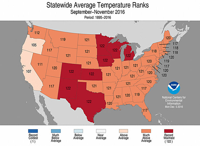
Sep-Nov Statewide Temperature Ranks
- The contiguous U.S. average temperature for September-November was 57.6°F, 4.1°F above the 20th century average, the warmest autumn period on record for the second consecutive year. The previous record from 2015 was 56.8°F.
- Temperatures were above average across nearly the entire country during autumn. Eight states were record warm (Colorado, Iowa, Kansas, Michigan, Minnesota, New Mexico, Texas and Wisconsin). An additional 27 states had an average autumn temperature that was either second or third warmest on record
- The warmest anomalies were located in the northern tier states, where Minnesota was 6.5°F above normal, Wisconsin 6.1°F above, Iowa 5.9°F above and Michigan 5.7°F above.
- For the contiguous U.S., both minimum (nighttime) temperatures and maximum (daytime) temperatures were warmest on record for autumn.
Precipitation
- Precipitation during autumn was near the middle of the record nationally, with wet extremes in the Northwest and dry extremes in the Central Rockies, Gulf Coast region and interior Southeast.
- Regional extremes dominated the precipitation patterns for autumn. It was the fourth wettest period in the Northwest. The state of Washington was record wet with 18.78 inches of precipitation, 7.05 inches above normal. Idaho and Montana also saw above normal precipitation
- Near-record dryness plagued the South and Southeast. Georgia had its third driest autumn, Kentucky its sixth, Tennessee its seventh, while both Alabama and Louisiana had their ninth driest such period. It was Colorado's eighth driest autumn, reflecting an area of dryness that pervaded the central Rockies during the period.
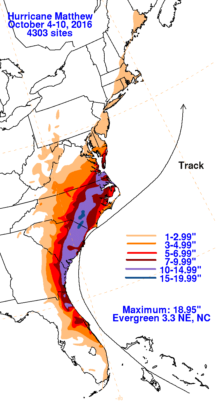
- Despite significant drought in the western Carolinas, much of the coastal southeast received above-normal precipitation, largely from the remnants of Hurricanes Hermine (early September) and Matthew (early October). Matthew's rains caused widespread destructive flooding along the coastal plain from northern Florida to southeastern Virginia.
- According to the November 29 U.S. Drought Monitor report, drought was resurgent during the season. The contiguous U.S. drought footprint expanded from 19.5 percent on August 30 to 31.5 percent on November 29. Drought intensified and expanded dramatically in the Southeast during autumn. By season's end, Exceptional Drought ("D4", the most severe category) had established across northern Georgia, northern Alabama and the Appalachian portions of the Carolinas and Tennessee. Drought also worsened in the ArkLaTex, Southern Plains and Northeast.

Sep-Nov Statewide Precipitation Ranks
Extremes
- The U.S. Climate Extremes Index (USCEI) for autumn was 115 percent above average, the highest value on record. On the national scale, extremes in warm maximum and minimum temperatures and one-day precipitation totals were much above average. The USCEI is an index that tracks extremes (falling in the upper or lower 10 percent of the record) in temperature, precipitation, land-falling tropical cyclones and drought across the contiguous U.S.
- Climate Highlights — January-November
 January-November Average Temperature Departures |
 January-November Percent of Average Precipitation |
Temperature
- The January-November temperature, averaged across the contiguous U.S., was 56.9°F for 2016, the second warmest value on record. The warmest on record is 2012, at 57.0°F.
- Louisiana (sixth warmest) is the only state to have a year-to-date temperature outside its five warmest on record. Seven states (Alaska, Georgia, Montana, North Carolina, North Dakota, South Carolina and Virginia) observed their warmest such period on record.
- The average temperature across Alaska was 6.2°F above normal, resulting in a record warm YTD period. Three out of the past four years have been record warm for Alaska.

January-November 2016 Statewide Temperature Ranks
Precipitation

January-November 2016 Precipitation Ranks
- The January-November precipitation, totaled across the contiguous U.S., was 28.96 inches, 1.37 inches above normal.
- Much above average precipitation fell in Wisconsin (second wettest), Minnesota (third wettest), Washington (eighth wettest) and Michigan (10th wettest). Conversely, Georgia had its sixth driest start to the year, while Connecticut had its seventh driest, and it was the eighth driest start for Massachusetts.
Extremes
- The U.S. Climate Extremes Index (USCEI) for autumn was 115 percent above average, the highest value on record. On the national scale, extremes in warm maximum and minimum temperatures and one-day precipitation totals were much above average. The USCEI is an index that tracks extremes (falling in the upper or lower 10 percent of the record) in temperature, precipitation, land-falling tropical cyclones and drought across the contiguous U.S.
**A comparison of the national temperature departure from average as calculated by NCDC's operational dataset (nClimDiv), the U.S. Historical Climatology Network (USHCN), and the U.S. Climate Reference Network (USCRN) is available on our National Temperature Index page.**
Regional Highlights:
These regional summaries were provided by the six Regional Climate Centers and reflect conditions in their respective regions. These six regions differ spatially from the nine climatic regions of the National Centers for Environmental Information.
- Northeast Region: (Information provided by the Northeast Regional Climate Center)
- For the seventh month in a row, the Northeast averaged out to be warmer than normal. The region's average temperature of 41.6 degrees F (5.3 degrees C) was 2.1 degrees F (1.2 degrees C) above normal, making it the 15th warmest November since recordkeeping began. All twelve states were warmer than normal, with departures ranging from 1.1 degrees F (0.6 degrees C) above normal in Delaware and Maryland to 3.3 degrees F (1.8 degrees C) above normal in Maine. Eight states ranked this November among their top 20 warmest: Maine, 10th warmest; Connecticut and New York, 16th warmest; New Jersey and Vermont, 17th warmest; Rhode Island and New Hampshire, 18th warmest; and West Virginia, 19th warmest. It was the third warmest autumn on record for the Northeast with an average temperature of 52.8 degrees F (11.6 degrees C), 2.9 degrees F (1.6 degrees C) above normal. State departures ranged from 2.3 degrees F (1.3 degrees C) above normal in Massachusetts to 3.7 degrees F (2.1 degrees C) above normal in West Virginia, with all twelve states ranking the season among their top 6 warmest. Maine, Maryland, Rhode Island, and West Virginia had their third warmest autumn on record, while Connecticut, Delaware, and Pennsylvania had their fourth warmest. New Hampshire and New York recorded their fifth warmest autumn on record, followed by Massachusetts, New Jersey, and Vermont with their sixth warmest. LaGuardia Airport, New York; Washington National, D.C.; and Bridgeport, Connecticut had their warmest autumn on record.
- November was a drier than normal month for the Northeast. The region received 2.35 inches (59.69 mm) of precipitation, which was 61 percent of normal. All twelve states saw below-normal precipitation, ranging from 27 percent of normal in Delaware and Maryland to 83 percent of normal in Maine. Maryland had its sixth driest November since 1895, while Delaware had its eighth driest and Pennsylvania had its 12th driest. The Northeast wrapped up autumn on the dry side of normal. The region picked up 9.50 inches (241.3 mm) of precipitation, which was 82 percent of normal. Delaware was the only wetter than normal state at 124 percent of normal, which made it the 17th wettest autumn on record. Precipitation for the dry states ranged from 68 percent of normal in Connecticut to 96 percent of normal in Rhode Island, with Vermont having its 19th driest autumn since recordkeeping began.
- The U.S. Drought Monitor released on November 3 showed 51 percent of the Northeast was experiencing moderate, severe, or extreme drought, with another 17 percent of the region abnormally dry. Drought conditions generally remained unchanged or worsened in an area from central Maryland northeast through central Maine. Western and northern New York saw improving conditions. The U.S. Drought Monitor released on December 1 indicated 54 percent of the Northeast was in a moderate, severe, or extreme drought, with another 24 percent being abnormally dry. In early November, Pennsylvania declared a Drought Warning for four counties (Monroe, Northampton, Carbon, and Lehigh), while thirty counties were in a Drought Watch and some counties returned to normal status. Western Massachusetts' drought level increased to a Drought Warning, while the Cape and Islands improved to a Drought Advisory. Western and central New York were reduced from a Drought Warning to a Drought Watch, which was also the drought status for the rest of the state. Streamflow during the month was generally near to below normal, with a few gauges having record to near record low streamflow. In early November, the New York Department of Environmental Conservation prohibited fishing along parts of Esopus Creek and Ashokan Reservoir because very low streamflow was stressing trout and additional stress could impact their ability to spawn. According to the Delaware River Basin Commission's website, low flows along the Delaware River in southern Pennsylvania and New Jersey allowed salt water to travel 19 miles upstream from its normal location for November, which resulted in the basin being placed in a Drought Watch on November 23. Groundwater and reservoir levels remained below normal in many of the drought-stricken areas. Worcester, Massachusetts's reservoir system was at 50.1% of capacity as of November 1, which was the lowest November 1 level since 1966. The city remained in a Stage 3 Drought Emergency. Data from the New Jersey Water Supply Authority showed that the Round Valley Reservoir fell to a new record low of 65.1% of capacity on November 28 and 29. As of November 30, the New York City reservoir system was at 56.3% of capacity compared to the normal 81.2%. Dry conditions also contributed to several wildfires in the region.
- On November 19, cold air and gusty winds moved in behind a strong low pressure system. Precipitation changed to snow, with some higher elevations getting up to a foot (0.3 m). Significant lake-effect snow fell from November 20-22, especially south and east of Lake Ontario. Numerous sites received more than a foot (0.3 m) of snow, with the greatest storm total of 54.5 inches (138.4 cm) in Oswego County, New York. The November 19-22 snowfall ranked as the greatest four-day total on record for Binghamton (27.6 inches, 70.1 cm) and the greatest four-day total for November for Syracuse (25.1 inches, 63.8 cm). It was the second snowiest November on record for Binghamton and the fourth snowiest on record for Syracuse. The winds and snow contributed to power outages, road closures, and numerous accidents.
- For more information, please go to the Northeast Regional Climate Center Home Page.
- Midwest Region: (Information provided by the Midwest Regional Climate Center)
- November temperatures ranked as the second warmest on record (1895-2016) for the Midwest as a whole. Temperatures for the month were 6.9 degrees F (3.8 C) above normal. All nine states in the region ranked among the warmest 10 percent in their respective histories with Iowa, Michigan, Minnesota, and Wis consin all ranking second. More than a thousand daily record highs were set in November versus just a handful of record lows. The fall (September-November) in the region set a new record for warmth, averaging 5.2 degrees F (2.9 C) above normal. New statewide records were set in Iowa, Michigan, Minnesota, and Wisconsin while the other five states in the region ranked as the second warmest on record. Year-to-date (January-November) temperatures for the region ranked as the second warmest with statewide temperatures ranking between second and fourth.
- Precipitation was mostly below normal in the Midwest in November. Only Minnesota reported a statewide value above normal for the month. Most of Missouri and Ohio received less than half of normal. Some parts of Missouri received less than a quarter of normal. A few pockets of slightly above normal p recipitation were scattered from Wisconsin to Indiana but the only area with significantly above normal precipitation was in Minnesota. Northeast Minnesota received as much as twice their normal total for the month. Fall precipitation was a mixed bag in the region with only Iowa, Minnesota, and Wisconsin above normal. Those three states ranked in the wettest 25 percent of their statewide histories. The other six states, and the region as a whole, were below normal for the season. Kentucky was well below normal with only half its normal total for the season, ranking as the sixth driest on record for the state.
- Drought in the southeastern US extended into Kentucky and conditions deteriorated in November. The month started out (November 1 US Drought Monitor) with 8 percent of the region and 82 percent of Kentucky in moderate drought. By the end of the month (November 29 US Drought Monitor) the coverage of mo derate drought had expanded slightly to 11 percent of the region and 98 percent of Kentucky, severe drought (90 percent of Kentucky) and extreme drought (25 percent of Kentucky) expanded across large parts of the state. Significant forest fires burned in eastern Kentucky during the month.
- First freeze came late to much of the Midwest. Dates of the first freeze and first hard freeze were weeks later than the median date for first freezes. Only the northern area had had a freeze prior to November, and nearly everywhere in the region had both a freeze and a hard freeze during November.< /li>
- Snowfall for the season was below normal for much of the Midwest. Measureable snow had not fallen yet in Illinois, Missouri, and Kentucky. Slightly over a third of the stations in the region had recorded snow through November in 2016, well behind the two-thirds who had reported snow through November in 2015. Snow totals were well below normal in Upper Michigan and below normal in most of the region. Only north central Minnesota was slightly above normal, largely due to a blizzard on the 18th and 19th which brought snowfall totals of up to 25 inches (63 cm) to the area. Nearly all of the snow had melted by the end of November.
- Severe convective weather was limited to only three days in November. On the 2nd, hail and strong winds were reported in Missouri and Illinois. On the 18th, strong winds were reported from east central Illinois, across Indiana, and into southeast Michigan. Three weak tornadoes touched down in central Iowa on the 28th.
- For further details on the weather and climate events in the Midwest, see the weekly and monthly reports at the Midwest Climate Watch page.
- Southeast Region: (Information provided by the Southeast Regional Climate Center)
- Mean temperatures ranged from near average to above average across the Southeast region during November. The greatest departures in mean temperature were found across Alabama, the Florida Panhandle, northern and southwestern Georgia, and western portions of the Carolinas and Virginia. Monthly departures were 3 to 5 degrees F (1.7 to 2.8 degrees C) above average in these areas, primarily due to well-above-average daytime maximum temperatures. Indeed, there were at least 35 long-term (i.e., period of record equaling or exceeding 50 years) stations across the region with average maximum temperatures during November that ranked within the top 3 warmest values on record. Two or more of these stations were located in every state except Virginia, including Montgomery, AL (76.3 degrees F; 24.6 degrees C), Pensacola, FL (76.3 degrees F), and Atlanta, GA (70.1 degrees F; 21.2 degrees C). Montgomery, AL (1872-2016) observed its second highest count of days during November with a maximum temperature at or above 70 degrees F (21.1 degrees C; 25 days) and 80 degrees F (26.7 degrees C; 10 days). Temperatures were above average in Puerto Rico and the U.S. Virgin Islands during the month, as San Juan, PR (1898-2016) tied its fifth warmest November mean temperature on record (81.4 degrees F; 27.4 degrees C). Within the Southeast, the warmest weather of the month occurred from the 1st through the 4th, as very warm, moist air pushed northwestward across the region ahead of a cold front. Daily maximum temperatures exceeded 80 degrees F across much of the region, with numerous locations in Alabama and Florida reaching the upper 80s F (30.6 to 31.7 degrees C). On the 1st, Montgomery, AL, Birmingham, AL (1895-2016), and Huntsville, AL (1907-2016) observed their highest daily maximum temperature for November on record, at 91 degrees F (32.8 degrees C), 88 degrees F (31.1 degrees C), and 88 degrees F, respectively. On the 4th, Pensacola, FL (1879-2016) and Mobile, AL (1872-2016) observed their highest daily maximum temperature for November on record, at 89 degrees F (31.7 degrees C) and 88 degrees F, respectively. In contrast, the coldest weather of the month occurred on the 21st and 22nd, as a continental high pressure system ushered in seasonably cold air from the northwest. Nighttime minimum temperatures fell below 30 degrees F (-1.1 degrees C) across a broad portion of the region, with a few locations in Virginia reaching the upper teens F (-8.3 to -7.2 degrees C).
- Precipitation was well below normal across the Southeast region during November, with numerous extremes recorded. Monthly precipitation totals were less than 50 percent of normal across much of the region, with no precipitation observed in pockets of Florida and southeastern Georgia. At least 37 long-term stations, with one or more located in nearly every state, observed November precipitation totals that were ranked within the three lowest values on record. Fort Myers, FL (1892-2016) and Tarpon Springs, FL (1892-2016) tied their driest November on record, with no measurable precipitation recorded during the month. Brunswick, GA (1948-2016) observed its driest November on record, with only 0.04 inches (1.0 mm) of precipitation. Several locations tied their highest count of November days with no measurable precipitation, including Montgomery, AL (1872-2016; 28 days), Atlanta, GA (1878-2016; 28 days), Charleston, SC (1938-2016; 28 days), and Charlotte, NC (1878-2016; 27 days). Record-breaking streaks of no rainfall were observed at numerous locations across the western portion of the region. Eufaula Wildlife Refuge, AL (1967-2016), located about 75 miles southeast of Montgomery, recorded its longest streak of 91 days with no measurable precipitation, ending on the 28th of the month. This is also the longest streak for any station in Alabama's historical record. Tuscaloosa, AL (1948-2016) and Birmingham, AL recorded their longest streak of 71 and 61 days, respectively, with no measurable rainfall. In southwestern Georgia, Plains Experiment Station (1956-2016) and Montezuma (1904-2016) recorded their longest streak of 72 days with no measurable rainfall. Precipitation was well above normal across much of Puerto Rico and the U.S. Virgin Islands during the month. San Juan, PR (1898-2016) observed its wettest November and second wettest month on record, with 17.65 inches (448 mm) of precipitation.
- There were 97 severe weather reports across the Southeast during the month, which is well above normal (based on the median frequency of 59 reports for November during 2000-2015). Nearly all of the reports were associated with a multi-day severe weather outbreak that affected a broad portion of the region on the 29th and 30th. Twenty-eight tornadoes (7 EF-0s, 15 EF-1s, 4 EF-2s, and 2 EF-3s) were confirmed in this outbreak, and this two-day count was more than double the median frequency of 11 tornadoes observed during November. About two-thirds of the tornadoes (19 of 28), including all of the EF-2s and EF-3s, occurred in Alabama. On the 29th, an EF-2 tornado touched down near Russellville, AL and caused significant damage to several homes along its 11-mile path. Three residents were injured by this tornado. Early on the 30th, an EF-3 tornado touched down near the town of Rosalie in northeastern Alabama and traveled nearly 14 miles to the Alabama-Georgia border. Numerous mobile homes and small buildings (including a strip mall and day care center) were destroyed along its path, resulting in 3 fatalities and 10 injuries. During the evening of the 30th, an EF-1 tornado touched down on the southeast side of Charlotte, NC. A few residential homes and commercial buildings sustained minor damage, and one injury was reported.
- Drought conditions intensified and expanded in coverage across the western half of the region during the month. In late November, a portion of every state in the region was classified in extreme (D3) drought for the first time since March 2008. Despite some beneficial rainfall from the 28th through the 30th, extreme-to-exceptional (D3-D4) drought covered approximately 97 percent of Alabama, 62 percent of Georgia, 21 percent of South Carolina, and 13 percent of North Carolina by the end of the month. Moderate-to-extreme (D1-D3) drought conditions developed across much of the Florida Panhandle, southwestern Virginia, and a portion of northern Virginia. A small area of moderate drought in southeastern Puerto Rico was eliminated during the month. Although the dry weather was favorable for harvesting activities, farmers in Georgia and Alabama struggled to dig up peanuts from excessively dry fields, and agricultural producers in the western Carolinas reported reduced yields of soybeans. Pastures and hay fields remained in very poor condition across drought-stricken portions of the region, which required livestock producers to sell off some cattle and continue feeding hay from diminishing reserves. In Alabama and Georgia, water for the cattle had to be hauled in by trailer, as ponds and streams continued to dry up. Cool season grains could not be planted for winter grazing in these areas because soil moisture levels were too low for seed germination. Across the interior portion of the region, the very dry forest floor coupled with seasonal leaf litter provided ideal conditions for an extraordinary number of wildfires, with over 180,000 acres burned during the month. About 28,000 acres of the Cohutta Wilderness in northern Georgia were burned by the Rough Ridge Fire, and thousands of North Carolina residents had to evacuate from several large fires, including the 7,142-acre Party Rock Fire near Lake Lure. The wind-driven transport of wildfire smoke caused poor air quality across a broad portion of the region, including the cities of Atlanta, GA, Asheville, NC, Charlotte, NC, and even cities farther away, such as Raleigh, NC and Charleston, SC. Respiratory issues were reported for both people and livestock in these affected areas. The extremely dry conditions caused large cracks to develop in many home foundations and roadways across northern Alabama.
- For more information, please go to the Southeast Regional Climate Center Home Page.
- High Plains Region: (Information provided by the High Plains Regional Climate Center )
- Above-normal temperatures continued into November throughout the High Plains. Many top 10 records for warmest November were set, as much of the region was 4.0-8.0 degrees F (2.2-4.4 degrees C) above normal. Departures were especially impressive in the Dakotas. In North Dakota, temperatures in Fargo and Grand Forks were 13.0 degrees F (7.2 degrees C) and 14.7 degrees F (8.2 degrees C) above normal, respectively, and Fargo, Grand Forks, Jamestown, and Minot all had their warmest Novembers on record. The continued warmth during the past few months led to some remarkable fall temperature records as well. The following is a selection of locations that experienced record-breaking warm falls: Colorado Springs, CO, Pueblo, CO, Salina, KS, and Aberdeen, SD (warmest); Bismarck, ND, Sioux Falls, SD, Omaha, NE, Wichita, KS, and Cheyenne, WY (2nd warmest); and Williston, ND and Rapid City, SD (3rd warmest).
- The continuation of above-normal temperatures resulted in several impacts around the region. Snowpack got off to a slow start in the Rockies. While some parts of the Rockies, such as the western half of Wyoming, received ample precipitation this fall, the warm temperatures caused precipitation to fall more as rain than snow. The warmth contributed to drought expanding across parts of every state in the High Plains region, especially in Colorado and Kansas. Colorado Springs, Colorado had its driest fall on record, and it was the 3rd driest in Dodge City, Kansas. Many locations experienced late first fall freezes. Although not in our region, it is worth noting that Minneapolis-St. Paul, Minnesota experienced its latest first fall freeze on record on November 18th (period of record 1873-2016). According to Nebraska Extension, several diseases were found in fall-planted wheat throughout the state. Stripe, stem, and leaf rust diseases were widespread in part due to extended above-normal temperatures into late fall. However, the warm temperatures did have some positive impacts. For example, the growing season was extended, allowing people to enjoy their garden plants and vegetables longer than usual, and it also helped accelerate harvest.
- November brought impressive warmth to the High Plains and continued the trend of above-normal temperatures experienced by the region throughout the fall. Departures of 4.0-8.0 degrees F (2.2-4.4 degrees C) above normal were widespread. However, it was even warmer across much of the Dakotas, where temperature departures exceeded 10.0 degrees F (5.6 degrees C) in several locations. For instance, the average temperature for November was a remarkable 14.7 degrees F (8.2 degrees C) above normal in Grand Forks, North Dakota. In fact, the average temperature was above normal every day of November in Grand Forks. The high temperature on the 4th, 5th, and 6th reached above 70.0 degrees F (21.1 degrees C), and these three days ranked in the top 10 for highest November temperature on record in Grand Forks (period of record 1893-2016). Other parts of the region experienced an especially warm day on the 16th, as quite a few daily records for highest maximum temperature were set. For example, it reached 80.0 degrees F (26.7 degrees C) in several locations, and Lincoln, Nebraska and Denver, Colorado had their latest 80.0 degrees F (26.7 degrees C) day on record. Also on the 16th, some places in Colorado set or tied a record for warmest November day, including Boulder, Colorado Springs, and Denver.
- Given the warm fall, it was not surprising that some locations experienced late freezes. By the end of October, southern and eastern Kansas had yet to reach the freezing mark. These locations did get their first fall freeze in November, although it occurred a few weeks later than the median date. In particular, the Manhattan, Kansas COOP station did not record a freeze this year until November 12th, which was its latest first fall freeze on record (period of record 1893-2016).
- November was mostly dry across the region with a few pockets receiving above-normal precipitation. The wettest areas included the eastern and central Dakotas where precipitation exceeded 150 percent of normal in many areas. It was especially wet in Pierre, South Dakota, which had its 8th wettest November on record. Otherwise, it was quite dry throughout the region, particularly in Kansas and parts of Colorado. A large part of Kansas received only 25 percent of normal precipitation, at best. It was the 10th driest November on record for Akron, Colorado. Pueblo, Colorado finally ended its streak of no measurable precipitation on the 17th. The streak lasted 63 days, which tied 1963 and 1934 for the 4th longest streak on record with no measurable precipitation in Pueblo (period of record 1888-2016).
- Two major storm systems impacted the High Plains during November. The first system came through on the 17th and 18th, following record-breaking high temperatures throughout the region. The storm brought large temperature swings, snow, and high winds to portions of Wyoming, Colorado, South Dakota, and Nebraska. Pueblo's streak of no measurable precipitation ended with this storm and, according to the National Weather Service Weather Forecast Office in Pueblo, thunder-graupel occurred at their office!
- The second storm system affected the region during the last week of the month. This system developed over the Dakotas and packed quite a punch, as it blanketed the northern Plains with snow and spawned severe weather in the Southeast U.S. As much as two feet of snow fell across western parts of North Dakota, and high winds and snow also caused problems in South Dakota, as Interstate 90 was closed in several locations.
- While severe weather is uncommon in the High Plains in November, it is not unheard of. This aforementioned system combined with warm and moist air streaming northward from the Gulf of Mexico to produce tornadoes in south-central Nebraska. Three tornadoes were confirmed on the 27th in that region, which is the first time on record that more than one tornado was ever reported during November in the state. According to the National Weather Service Weather Forecast Office in Hastings, it was the second-latest day of the year that tornadoes have occurred in Nebraska, and it was only the fourth time since 2000 that Nebraska saw a tornado in November.
- Snowpack got off to a slow start in the Rockies this year. As of the end of November, most SNOTEL sites in Wyoming and Colorado were reporting a snow-water equivalent of approximately 50-75 percent of median. According to the U.S. Army Corps of Engineers, mountain snowpack water content was well below the 1981-2010 average going into December in the Missouri River Basin above Fort Peck and from Fort Peck to Garrison. To date, the mountain snowpack water content was at or below the levels of 2001, which is considered the lowest snowpack year during the last 20-year period. Snowpack was below normal in large part due to a warm fall, and precipitation fell mostly as rain instead of snow. Dryness also contributed to the issue, especially in Colorado. Despite the abysmal snowpack, it is early in the season and there is ample time for mountain snowpack recovery. < /li>
- The continuation of dry conditions into November resulted in wide expansion of drought throughout parts of the High Plains region. Since late October, the area in drought (D1-D4) expanded from about 9 percent to 22 percent, and the area experiencing drought or abnormal dryness (D0-D4) increased from approximately 38 percent to 60 percent. Degradations in drought conditions occurred in all six states in the High Plains region.
- Colorado and Kansas saw the biggest expansion of drought during the past month. Nearly all (98 percent) of Colorado was experiencing at least abnormal dryness (D0), and 35 percent of the state was in moderate drought (D1) or severe drought (D2), most of which was occurring in the eastern half of the state. Meanwhile, the western half of Kansas has been particularly dry, and nearly 11 percent of the state was contending with D2 conditions. Eastern Colorado and western Kansas had a very dry fall, with much of the area receiving no more than 50 percent of normal precipitation.
- Several impacts have been reported as a result of drought conditions. Soil moisture was depleted across a large part of the region, especially in Colorado, Wyoming, Kansas, and Nebraska. Snowpack got off to a slow start in the Rockies. In Wyoming, the dryness increased the risk for rangeland fires, and winter wheat was challenged for growth. Diseases were already emerging in the winter wheat crop in western Kansas. Moisture is badly needed before the ground freezes to ensure adequate soil moisture in the spring for crop growth.
- For more information, please go to the High Plains Regional Climate Center Home Page.
- Southern Region: (Information provided by the Southern Regional Climate Center)
- As was the case in October, 2016, all six states in the Southern Region posted state-wide average monthly temperatures that were much warmer than normal. Three states, Arkansas, Oklahoma, and Texas all recorded their top five warmest November on record . The remaining three states of Louisiana, Mississippi, and Tennessee all experienced monthly temperatures in their top 20 of all Novembers on record. In Arkansas, Louisiana, Mississippi and Tennessee, temperatures ranged from 2-6 degrees F (1.11-3.33 degrees C) above normal. In the western states of Oklahoma and Texas, temperatures ranged from 2-8 degrees F (1.11-4.44 degrees C) above normal. The statewide monthly average temperatures were as follows: Arkansas reporting 55.60 degrees F (13.11 degrees C), Louisiana reporting 62.00 degrees F (16.67 degrees C), Mississippi reporting 58.30 degrees F (14.61 degrees C), Oklahoma reporting 55.50 degrees F (13.06 degrees C), Tennessee reporting 52.60 degrees F (11.44 degrees C), and Texas reporting 61.10 degrees F (16.17 degrees C). The state-wide temperature rankings for May are as follows: fifth warmest for Arkansas, thirteenth warmest for Louisiana, fifteenth warmest for Mississippi, second warmest for Oklahoma, eleventh warmest for Tennessee, and second warmest for Texas. All state rankings and records are based on the period spanning 1895-2016.
- With the exception of west-central Texas, the Southern Region experienced a third consecutive drier than normal month. Precipitation totals ranged from 50 to 70 percent of normal in Louisiana, Arkansas, Mississippi, and Tennessee. In Oklahoma, conditions were slightly drier, with many stations reporting less than half the expected precipitation, particularly in the north eastern quadrant of the state. In Texas, conditions were generally quite wet in the west central counties, with most stations reporting over twice the amount of normal precipitation. The state-wide precipitation totals for the month are as follows: Arkansas reporting 3.25 inches (82.55 mm), Louisiana reporting 3.07 inches (77.98 mm), Mississippi reporting 3.14 inches (79.76 mm), Oklahoma reporting 1.24 inches (31.50 mm), Tennessee reporting 3.10 inches (78.74 mm), and Texas reporting 2.30 inches (58.42 mm). The state precipitation rankings for the month are as follows: for Arkansas it was the forty-sixth driest, for Louisiana it was the forty-third driest, for Mississippi it was the forty-first driest, for Oklahoma it was the forty-first driest, for Tennessee it was the thirty-eighth driest , and for Texas it was the thirty-seventh wettest. All state rankings are based on the period spanning 1895-2016.
- Drought conditions over the month of November have deteriorated in the Southern Region. This is primarily due to the combination of the higher water demand produced by above normal temperatures, and a significant lack in precipitation. Though the amount of total drought coverage has changed little over the past month, the severity of the drought areas has changed significantly. Over the past month, the amount of areal coverage of extreme drought (D3) or worse has increased from 3.60 percent at the start of the month, to just over 13 percent near the end of the month. Extreme drought is currently observed in central Louisiana, central and eastern Tennessee, and over the majority of Mississippi. The state of Arkansas has also observed an increase in the amount of severe drought (D2) or worse.
- In Texas, crops across the state are expected to be a mixed bag thanks to drought conditions increasing across the state during the month of October. According to state agronomist Mark Welch, only 86 percent of winter wheat was planted compared to the five year average of 88 percent and the percentage of poor and very poor rating increased by 5 percent. Some top cotton producers, however, are expected to turn out in good conditions after the forecast was poor thanks to timely rains. Thanksgiving dinner is expected to cost more this year. Some dairy products and poultry saw price reductions compared to last year while vegetables mostly saw prices increases. The duck and waterfowl began this month and hunters are optimistic. Above-average rainfall over the past two years has primed conditions for the birds. The only thing hunters need is a blast of cold air to bring the birds south towards warmer temperatures. (Information provided by the Texas Office of State Climatology).
- In Texas, the first significant blast of cold air occurred about mid month with areas in the Panhandle, North Texas, and Central Texas seeing their first freezing temperatures of the season. Severe storms producing hail in the El Paso area caused more than $100 million of damage according to the Insurance Council of Texas (Information provided by the Texas Office of State Climatology).
- Twenty people were reported injured when a tornado touched down in McMinn County, Tennessee on November 29, 2016. The twister developed near the intersection of county roads 700 and 705. This tornado was a associated as part of a larger tornadic outbreak from a squall line that resulted in dozens of tornadoes spanning Louisiana, Mississippi, Alabama and Tennessee.
- For more information, please go to the Southern Regional Climate Center Home Page.
- Western Region: (Information provided by the Western Region Climate Center)
- November was drier than normal across much of the West, most notably in the intermountain region. Areas of above normal precipitation were observed along the Pacific Northwest coast, across Arizona and New Mexico, and in the Wyoming Rockies. Temperatures were above normal West-wide, with the greatest departures, in excess of 6 F (3.3 C) above normal, observed across the northern tier of the region.
- Several storm systems impacted the West in November, though they were generally moisture-limited and did not produce significant precipitation totals beyond the coastal mountains. In the Pacific Northwest, Quillayute, Washington, recorded 25.72 in (653 mm) of rainfall, 166% of normal. This was the 4th wettest November since records began in 1966. Further south, Eureka, California, logged 7.2 in (183 mm) in November, 107% of normal and the 7th wettest since records began in 1945. In southern California, scattered coastal areas observed near normal precipitation, beneficial for the drought-stricken area. Pismo Beach recorded 1.91 in (49 mm), 126% of normal. Arizona and New Mexico observed above normal precipitation, most of it associated with two storms. The first, a cutoff low-pressure system, produced widespread thunderstorms during the 3rd-5th. The second storm, a deep trough moving in from the Pacific, impacted the area on the 21st-22nd. In northeastern Arizona, Show Low reported a monthly precipitation total of 2.55 in (65 mm), 193% of normal. This was the 3rd wettest November in a 33-year record. Albuquerque, New Mexico, recorded 1.03 in (26 mm), 180% of normal and the 12th wettest November since records began in 1891. In western Wyoming, Lander reported 1.49 in (38 mm) precipitation for the month, 173% of normal. This was the 11th wettest November in Lander since records began in 1946. Drought conditions in the western Great Basin were scaled back this month in the US Drought Monitor. This was attributed mostly to October rains that reduced the long-term precipitation deficit and improved soil moisture and stream flow rather than November precipitation. Drought improvement was also noted in northern New Mexico and along the western Wyoming-Montana border.
- A broad upper level ridge dominated over the northern tier of the region this month, supporting drier than normal conditions over the Great Basin, Inland Northwest, and Montana. Along the Oregon-Nevada border, Denio reported only 0.03 in (0.8 mm), 3% of normal and the 3rd driest November since records began in 1951. Helena, Montana, observed only 0.02 in (0.5 mm) precipitation, 4% of normal and 2nd driest in a 79-year record. Small areas of Colorado and Montana saw expansion of drought conditions this month, mostly just denoting abnormally dry conditions.
- The ridge producing dry conditions over the northern interior West also favored above normal temperatures. In eastern Washington, Spokane observed an average November temperature of 43.5 F (6.4 C). This was 7.8 F (4.3 C) above normal and the 4th warmest since records began in 1881. Further east, Lewistown, Montana, reported a November average temperature of 41.8 F (5.4 C), 9.8 F (5.4 C) above normal and the 5th warmest in a record that began in 1896. Coastal southern California experienced a heat wave and Santa Ana winds roughly November 9-14th. Chula Vista reported its hottest November day in a 99-year record, reaching 98 F (36.7 C) on the 9th. San Diego logged its second warmest November on record at 65.8 F (18.8 C), 4.5 F (2.5 C) above normal. Records for San Diego began in 1939. There were no locations in the contiguous West reporting below normal average temperatures this month.
- In Alaska, the first two-thirds of the month were much warmer than normal across the majority of the state. The last third of the month saw the first consecutive days of below normal temperatures statewide in 2016; many interior locations saw temperatures below -30 F (-34.4 C). Average November temperatures in areas north of the Brooks Range were 5-10 F (3-6 C) above normal. From Fairbanks to Anchorage and down through southeast Alaska, temperatures were 2-4 F (1-2 C) above normal. The west-central region from Nome to Bethel was slightly cooler than normal. Precipitation was below normal in a large swath from Bethel to Anchorage north to the Brooks Range - including the entirety of the interior. Along the North Slope, Kuparuk reported 0.8 in (20 mm) precipitation, 533% of normal and its wettest November since records began in 1983. Precipitation in southeastern and southwestern Alaska was near normal. Further south, drier than normal conditions were observed throughout Hawaii, resulting in expansion of drought conditions on the leeward sides of all major islands. Lihue, Kauai, reported its driest November on record at 0.4 in (10 mm), 9% of normal. Records for Lihue began in 1950. Temperatures were variable across Hawaii, with some locations reporting above and some below normal. Molokai Airport recorded an average November temperature of 77.4 F (25.2 C), 2.6 F (1.4 C) above normal and the warmest since records began in 1949.
- November (all month): Slow start to snowpack in some parts of West: November storms added to the emerging snowpack across western mountains, though totals were generally not substantial. The central Great Basin, northern Sierra Nevada, Cascades, and southern Utah are off to a good start with snow water equivalent (SWE) generally >75% of normal. Across the Rockies and southern Sierra Nevada, SWE is generally below 75% of normal, with much of the northern Rockies seeing <50% of normal. However, it is early in the season and small amounts of snow can make the difference between being well above and well below normal at this point.
- For more information, please go to the Western Regional Climate Center Home Page.