National Overview:

- Climate Highlights — summer (June-August)
 Jun-Aug Average Temperature Departures |
 Jun-Aug Percent of Average Precipitation |
Temperature
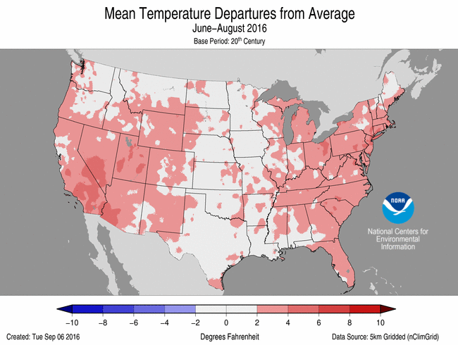
- The summer (June-August) temperature for the contiguous U.S. was 73.5°F, or 2.1°F above the 20th century average, tying 2006 as the fifth warmest in the 122-year period of record.
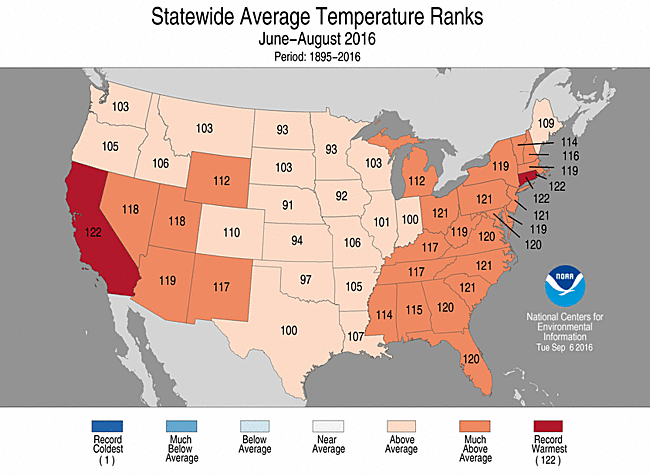
- Above-average temperatures spanned the nation during summer. Every state across the contiguous U.S. had a statewide temperature that was above average. Twenty-nine states across the West and in the East were much warmer than average.
- California, Connecticut and Rhode Island each had their warmest summer on record. The California statewide average temperature was 75.5°F, 3.3°F above average, the Connecticut statewide average temperature was 71.9°F, 3.7°F above average, and the Rhode Island statewide average temperature was 71.6°F, 3.7°F above average.
- Alaska observed its second warmest summer in its 92-year record at 53.6°F, 3.0°F above average. Only the summer of 2004 was warmer with a statewide temperature value of 55.9°F. Several locations across the state were record warm including Anchorage, Kenai, King Salmon and Yakutat.
- The contiguous U.S. average maximum (daytime) temperature during summer was 86.2°F, 1.8°F above the 20th century average, the 10th warmest on record. Above-average maximum temperatures were observed for both the eastern and western U.S. with near-average maximum temperatures across the Great Plains and parts of the Midwest. California and Rhode Island each had a record warm summer maximum temperature at 3.3°F and 4.2°F above average, respectively.
- The contiguous U.S. average minimum (nighttime) temperature during summer was 60.8°F, 2.4°F above the 20th century average, the warmest on record. This surpassed the previous record of 60.7°F in 2010. Every state across the Lower 48 had an above-average summer minimum temperature with 36 states much warmer than average. Ohio had a record warm summer minimum temperature at 63.2°F, 3.9°F, surpassing the previous record of 63.1°F in 2010.
- Based on NOAA's Residential Energy Demand Temperature Index (REDTI), the contiguous U.S. temperature-related energy demand during summer was 147 percent above average and the third highest value on record, driven in large part to warm temperatures across the densely populated Northeast.
June-August Statewide Temperature Ranks
Precipitation
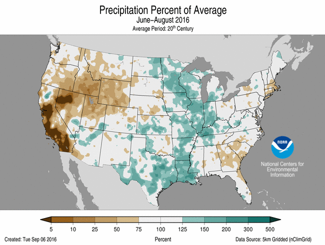
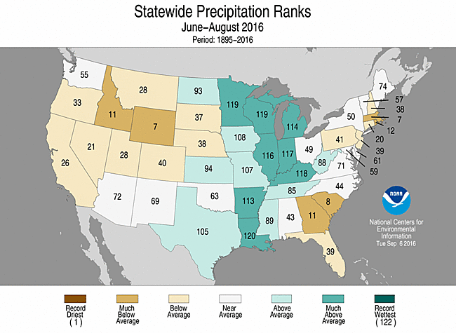
- The summer (June-August) precipitation total for the contiguous U.S. was 8.92 inches, 0.60 inch above average, and tied 1923 as the 24th wettest in the 122-year period of record.
- Above-average precipitation was widespread across the Midwest and Lower Mississippi Valley where eight states were much wetter than average.
- Below-average precipitation was observed across the West, Southeast and Northeast where six states were much drier than average. No state had a summer precipitation total that was record wet or dry.
June-August Statewide Precipitation Ranks
Extremes
- The U.S. Climate Extremes Index (USCEI) for the summer was 15 percent above average and the 22nd highest value on record. On the national scale, extremes in warm maximum and minimum temperatures were much above average. The USCEI is an index that tracks extremes (falling in the upper or lower 10 percent of the record) in land-falling tropical cyclones, temperature, precipitation and drought across the contiguous U.S.
- Regionally, extremes were much above-average in the Northeast, Southeast, Southwest, and West. The Northeast had its fifth highest CEI value due to elevated extremes in warm maximum and minimum temperatures and one-day precipitation totals. In the Southeast and Southwest extremes in maximum and minimum temperatures were much above average and in the West warm temperatures combined with days without precipitation contributed to the above-average CEI.
- Climate Highlights — August
 August Average Temperature Departures |
 August Percent of Average Precipitation |
Temperature
- The August temperature was 73.6°F, 1.5°F above the 20th century average, making it the 17th warmest on record.
- Above-average temperatures were observed along both coasts. Twenty-four states were much warmer than average, eight of which — Connecticut, Delaware Maryland, Massachusetts, New Jersey, New York Pennsylvania and Rhode Island — were record warm. Alaska had its third warmest August with a statewide temperature 3.8°F above average.
- Below-average temperatures were observed for parts of the Great Plains, Rocky Mountains and Southwest. Above-average precipitation across those regions suppressed daytime temperatures.
- The contiguous U.S. average maximum (daytime) temperature during August was 85.8°F, 0.7°F above the 20th century average, the 38th warmest on record. Above-average maximum temperatures were observed for both coasts with much above average maximum temperatures in the Northeast. Connecticut, Delaware, Massachusetts, Rhode Island, and New Jersey had record warm maximum temperatures. Below-average maximum temperatures were observed across the Southern and Central Plains, Lower Mississippi Valley, and Southwest, where above-average precipitation suppressed daytime temperatures.
- The contiguous U.S. average minimum (nighttime) temperature during August was 61.3°F, 2.2°F above the 20th century average, the sixth warmest on record. Above-average minimum temperatures were observed for much of the East and West Coast with near-average minimum temperatures for the Rockies and Central Plains. Eight states from North Carolina to Connecticut had a record warm August minimum temperature.
- Based on NOAA's REDTI, the contiguous U.S. temperature-related energy demand during August was 108 percent above average and the second highest value on record, driven in large part to warm temperatures across the heavily-populated East Coast, Great Lakes, Southeast, and West Coast regions.
- During August there were 4,826 record warm daily high (1,149) and low (3,677) temperature records, which is nearly three times the 1,622 record cold daily high (1,110) and low (512) temperature records.

August 2016 Statewide Temperature Ranks
Precipitation
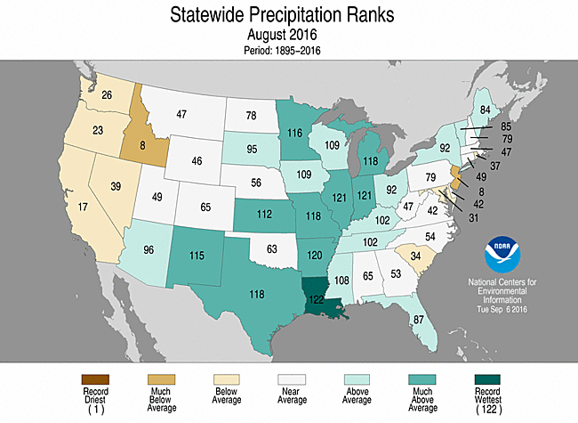
August 2016 Precipitation Ranks
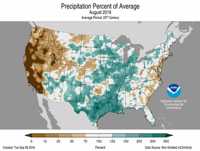
- The August precipitation total for the contiguous U.S. was 3.47 inches, 0.85 inch above the 20th century average, and the second wettest on record. The contiguous U.S. precipitation total was second only to 1977.
- Record and near-record precipitation was observed across parts of the Southwest, Southern Plains and Midwest. Ten states had monthly precipitation totals that were much above-average with the Louisiana precipitation total record high. The Louisiana statewide precipitation total was 12.91 inches, 8.27 inches above average, and surpassed the previous record of 9.71 inches in 1948.
- In mid-August, a nearly stationary low pressure system dumped torrential rainfall across southern Louisiana causing record flooding for large parts of the state. Precipitation totals over 20 inches were widespread with localized totals exceeding 30 inches. The U.S. Climate Reference Network (USCRN) station at Lafayette, Louisiana received 22.89 inches on the 11th and 12th, setting a new record for highest two-day precipitation total for any USCRN station in the contiguous U.S. The record flooding contributed to at least 13 fatalities.
- Below-average precipitation was observed across parts of the East Coast and the West. Dry conditions continued in the West contributed to ideal wildfire conditions, with over 100 homes destroyed by wildfires in California where the Chimney and Blue Cut fires cumulatively charred over 82,000 acres.
- Several weather systems brought heavy precipitation to Hawaii during August, including Tropical Storm Madeline, which brushed southern parts of the state at the end of the month. Hilo observed 24.68 inches of precipitation, marking the fourth wettest August for the city. The rainfall helped to alleviate drought for most of the Big Island with only 5.8 percent of the state experiencing drought conditions by month's end.
- According to the August 30 U.S. Drought Monitor report, 19.5 percent of the contiguous U.S. was in drought, down about 1.6 percent compared to the beginning of August. Drought conditions worsened and expanded across parts of the Southeast, Northeast, and Northern Rockies. Drought reduction was observed across parts of the Great Plains, Southeast and Midwest.
- Climate Highlights — year-to-date (January-August)
 Jan-Aug Average Temperature Departures |
 Jan-Aug Percent of Average Precipitation |
Temperature
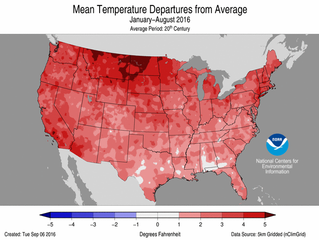
- The year-to-date (January-August) contiguous U.S. average temperature was 56.7°F, 2.8°F above average, ranking as the 3rd warmest.
- Much like summer, above-average temperatures spanned the contiguous U.S. for the year-to-date. Forty-five states observed much above average temperatures for the first eight months of the year, contributing to the third warmest year-to-date on record. Only 2006 and 2012 were warmer. No state in the contiguous U.S. had a record warm year-to-date.
- The Alaska year-to-date temperature was 36.4°F, 7.6°F above average, surpassing the previous record warm January-August of 1981 by 3.0°F. Record and near-record warmth engulfed Alaska for much of 2016.
- The contiguous U.S. average maximum (daytime) temperature during January-August was 68.6°F, 2.6°F above the 20th century average, the fifth warmest on record. Every state across the contiguous U.S. had an above-average maximum temperature with much above average maximum temperatures across the West, Rockies, Central and Northern Plains, Great Lakes, and Northeast.
- The contiguous U.S. average minimum (nighttime) temperature during January-August was 44.7°F, 3.0°F above the 20th century average, the second warmest on record. The minimum temperature during January-August 2012 was 45.3°F. Every state had a much above average minimum temperature during the year-to-date with Montana record warm at 35.3°F, 4.3°F above average.
- Based on NOAA's REDTI, the contiguous U.S. temperature-related energy demand during January-August was 50 percent below average and the 12th lowest value on record.
January-August Statewide Temperature Ranks
Precipitation
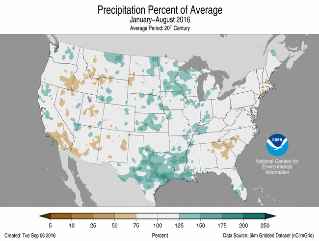
- The year-to-date (January-August) contiguous U.S. precipitation total was 22.03 inches, 1.32 inch above average, and the 25th wettest.
- Above-average precipitation was observed across parts of the Great Plains, Lower Mississippi Valley, Midwest, Northwest and Mid-Atlantic, where five states were much wetter than average. Below-average precipitation fell across the Northern Rockies, Southeast and Northeast where two states were much drier than average. No state was record wet or dry for the year-to-date.
Jan-August Statewide Precipitation Ranks
Extremes
- The USCEI for the year-to-date was 55 percent above average and the tenth highest value on record. On the national scale, extremes in warm maximum and minimum temperatures, the spatial extent of wetness and one-day precipitation totals were much above average.
- Regionally, the CEI was much above average for the Northeast, Upper Midwest, Ohio Valley, Northern Rockies and Plains, and South. In the Northeast, Upper Midwest, and Northern Plains and Rockies the elevated CEI was due to extremes in warm maximum and minimum temperatures. In the Ohio Valley and South, extremes in warm minimum temperatures and the spatial extent of wetness were above average.
**A comparison of the national temperature departure from average as calculated by NCDC's operational dataset (nClimDiv), the U.S. Historical Climatology Network (USHCN), and the U.S. Climate Reference Network (USCRN) is available on our National Temperature Index page.**
Regional Highlights:
These regional summaries were provided by the six Regional Climate Centers and reflect conditions in their respective regions. These six regions differ spatially from the nine climatic regions of the National Centers for Environmental Information.
- Northeast Region: (Information provided by the Northeast Regional Climate Center)
- The Northeast had its warmest August on record with an average temperature of 71.9 degrees F (22.2 degrees C), 3.7 degrees F (2.1 degrees C) above normal. Connecticut, Delaware, Maryland, Massachusetts, New Jersey, New York, Pennsylvania, and Rhode Island were all record warm. West Virginia had its second warmest August on record, followed by Vermont and New Hampshire with their sixth warmest and Maine with its tenth warmest. State departures ranged from 2.3 degrees F (1.3 degrees C) above normal in Maine to 4.4 degrees F (2.4 degrees C) above normal in Pennsylvania. Fifteen of the region's 35 major climate sites had a record warm August. Summer 2016 averaged out to be the fourth warmest on record for the Northeast. The region's average temperature of 69.7 degrees F (20.9 degrees C) was 2.0 degrees F (1.1 degrees C) above normal. Connecticut and Rhode Island were record warm, while the rest of the region ranked this summer among their top 15 warmest: New Jersey and Pennsylvania, second warmest; Maryland, third warmest; Delaware, Massachusetts, New York, and West Virginia, fourth warmest; New Hampshire, seventh warmest; Vermont, ninth warmest; and Maine, 15th warmest. State departures ranged from 1.0 degree F (0.6 degrees C) above normal in Maine to 2.6 degrees F (1.4 degrees C) above normal in Connecticut. Williamsport, Pennsylvania and Bridgeport, Connecticut also had a record warm summer.
- During August, the Northeast picked up 3.93 inches (99.82 mm) of precipitation, or 101 percent of normal. Eight states were drier than normal, with amounts ranging from 48 percent of normal in New Jersey, its eighth driest, to 99 percent of normal in New Hampshire. For the wetter-than-normal states, totals ranged from 103 percent of normal in Vermont to 112 percent of normal in Maine. Summer precipitation for the Northeast averaged out to be 11.38 inches (289.05 mm), or 92 percent of normal. Nine states were drier than normal, with three ranking the season among their top 20 driest: Massachusetts, seventh driest; Rhode Island, 12th driest; and Connecticut, 20th driest. Precipitation for all twelve states ranged from 59 percent of normal in Massachusetts and Rhode Island to 115 percent of normal in West Virginia. Boston, Massachusetts had its driest summer in 145 years of record.
- The U.S. Drought Monitor released on August 4 indicated 27 percent of the Northeast was in a moderate or severe drought, with another 32 percent being abnormally dry. Below-normal precipitation led to intensifying drought conditions mid-month, with extreme drought introduced in parts of New York and New England. It was the first time several counties had experienced extreme drought since at least 2000, which is when Drought Monitor data began. Some rain later in the month led to slight improvements in a few spots and generally kept conditions from worsening elsewhere. The September 1 Drought Monitor showed 27 percent of the region was experiencing moderate, severe, or extreme drought, with another 31 percent being abnormally dry. In early August, Pennsylvania issued a Drought Warning for Potter County and a Drought Watch for 34 other counties, while New York upgraded 22 counties to a Drought Warning. Later in the month, Rhode Island declared a statewide Drought Advisory, while Massachusetts upgraded each of their regions by one level (i.e. watch to warning, etc.). Streamflow and groundwater levels were at record or near record low levels and reservoir levels remained below normal. There continued to be reports of wells going dry in the drought region. As of August 29, Scituate, MA's reservoir was at 21.5 percent of capacity. Water bans and restrictions were in place for more than 165 Massachusetts and more than 115 New Hampshire water systems at the end of August. Warm temperatures, a lack of rain, and low water levels led a few fish-kills (in Connecticut) and heat-stressed fish. As a result, state officials in Pennsylvania and Connecticut closed parts of several waterways to protect the fish. According to the USDA Farm Service Agency (FSA), crop losses in Massachusetts are estimated to exceed $13 million as of late August for the 2016 growing season for those producers participating in FSA programs. The largest losses, of over 50 percent, were hay crops. Farmers in 24 New York counties, eight New Hampshire counties, four Pennsylvania counties, and three Massachusetts counties are eligible for federal assistance. Grape growers in the drought region indicated berries were ripening faster and were expected to be smaller-sized, but higher quality. Due to the elevated fire risk in Massachusetts, state firefighters were not sent to help fight fires in the western U.S. as they normally would. According to the Massachusetts chief fire warden, the drought made fighting fires in the state more labor intensive.
- Severe thunderstorms affected the Northeast several times during August. There were seven weak tornadoes: two each in New York and Pennsylvania and one each in Maryland, Connecticut, and Massachusetts. The tornadoes uprooted or snapped dozens of trees and caused some structural damage. Strong thunderstorm winds of up to 90 mph (40 m/s) caused similar damage. There were a few reports of hail, with the largest stones up to 1.75 inches (4.45 cm) in diameter, or golf ball-sized. Heavy rain led to a few flash flooding events, with reports of closed roads and water into buildings. In addition, there were five lightning fatalities: four in New York and one in Pennsylvania. By comparison, New York had four lightning fatalities from 2006 to 2015 (data from NOAA's lightning safety website).
- For more information, please go to the Northeast Regional Climate Center Home Page.
- Midwest Region: (Information provided by the Midwest Regional Climate Center)
- August temperatures were above normal for the Midwest. The region as a whole ranked as the 16th warmest in the 122 year record with temperatures 2.2 degrees F (1.2 C) above the 1981-2010 normal. Temperatures ranged from near normal in the western edge of the region to more than 5 degrees F (3 C) above normal in eastern Ohio. Statewide temperatures were above normal in all nine states with Ohio (ranked 3rd), Michigan (5th), Kentucky (10th), and Indiana (11th) falling in the warmest 10 percent since 1895. The warmth was due to warm nighttime temperatures more so than daytime temperatures. Dewpoint temperatures, and thus humidity, were above normal throughout the summer in the Midwest. Summer (June, July, and August) temperatures were also above normal. The region as a whole ranked as the 15th warmest on record with all nine states above normal. Summer in Ohio (2nd) and Michigan (11th) ranked among the warmest 10 percent in the period of record. Year-to-date (January to August) temperatures ranked among the warmest 10 percent in all nine states and the region as a whole.
- August precipitation was above normal for nearly the entire region with very wet conditions (more than twice normal) scattered across all nine Midwest states. On average across the region, precipitation was more than 50 percent above normal ranking as the 2nd wettest August since 1895. All nine states ranked among the wettest 25 percent on record with Illinois and Indiana ranking 2nd statewide, Michigan and Missouri 5th, and Minnesota 7th. Summer and year-to-date precipitation was above normal in every state except Ohio. Summer rainfall ranked 5th for the region and among the wettest 10 percent in six states. The wet summer in 2016 fell just short of the 2015 summer which ranked 4th wettest. Year-to-date precipitation ranked 13th for the region and among the wettest 10 percent in three states.
- Abundant rainfall in August has reduced drought in the Midwest to less than 2 percent of the region, mostly in northern Ohio. Soil moisture is well above average for August and stream flows are also well above average for most locations. Flooding and flash flooding was a problem especially late in the month.
- Conditions of corn and soybeans were good or excellent in more than 70 percent of seven states according to the NASS Crop Progress report. Michigan was lower with only 58 percent of the corn and 64 percent of the soybeans rated such. Ohio had only 45 percent of corn and 54 percent of soybeans rated good or better. The poorer crop conditions in Ohio and Michigan were due to dryness earlier in the summer.
- Severe weather was widespread in both time and space. Only four days in the month (6th-8th and the 21st) had no reports of severe weather. Tornadoes were reported on 12 days throughout the month with the busiest days on the 20th and the 24th. All nine states reported tornadoes in August and also thunderstorm wind damage. Only Michigan escaped large hail during the month. The largest hail fell in Minnesota on the 10th (2 inches or 5 cm) and the 28th (2.5 inches or 6 cm). An EF-2 tornado was reported near Indianapolis, Indiana on the 15th. Multiple EF-2 tornadoes struck Indiana and Ohio on the 24th with an EF-3 tornado the same day near Kokomo, Indiana responsible for 20 injuries. Northwestern Minnesota was hit by an EF-2 tornado on the 28th.
- For further details on the weather and climate events in the Midwest, see the weekly and monthly reports at the Midwest Climate Watch page.
- Southeast Region: (Information provided by the Southeast Regional Climate Center)
- Temperatures were well above average across the Southeast region, with numerous record-breaking extremes observed during August. Mean temperature departures were 1 to 4 degrees F (0.6 to 2.2 degrees C) above average across much of the region, with a few locations in North Carolina and Virginia reaching 5 degrees F (2.8 degrees C) above average. At least 48 long-term (i.e., period of record exceeding 50 years) stations across the region, with at least one station in every state, observed August mean temperatures that were ranked within the top 3 warmest values on record. Charleston, SC (1938-2016) and West Palm Beach, FL (1888-2016) observed their warmest August mean temperature on record, at 83.8 and 85.0 degrees F (28.8 and 29.4 degrees C), respectively. While relatively few daily temperature extremes were observed during August, the persistence of daytime heat and nighttime warmth was exceptional for many locations. Several stations observed or tied their highest count of days during August with a maximum temperature at or above 90 degrees F (32.2 degrees C), including Daytona Beach, FL (1923-2016; 29 days), Charleston, SC (28 days), and Washington, D.C. (1872-2016; 23 days). Ending on the 19th of the month, Athens, GA (1893-2016) recorded its longest streak of 52 days with a maximum temperature of at least 90 degrees F. A few stations observed a minimum temperature at or above 70 degrees F (21.1 degrees C) on all 31 days during the month, including Atlanta, GA (tied for the highest count on record, 1879-2016) and Birmingham, AL (tied for the highest count on record, 1896-2016). Ending on the 23rd of the month, Wilmington, NC (1873-2016) recorded its longest streak of 58 days with a minimum temperature of at least 70 degrees F. Temperatures were above average in Puerto Rico and the U.S. Virgin Islands during the month. Across the Southeast, the coolest weather of the month occurred from the 22nd through the 24th, as a continental high pressure system ushered in cooler and drier air across the northern portion of the region. Daily maximum temperatures remained below 90 degrees F, and nighttime minimum temperatures fell below 70 degrees F, with numerous locations in the North Carolina and Virginia mountains reaching the 50s F (10.0 to 15.0 degrees C).
- Precipitation was highly variable across the Southeast region during August, with numerous extremes recorded. The driest locations were found across northeastern Florida, east-central Georgia, central and coastal South Carolina, eastern North Carolina, and southeastern Virginia. Monthly precipitation totals were between 5 and 50 percent of normal in these areas. Florence, SC (1948-2016) and Richmond, VA (1887-2016) observed their driest and third driest August on record with 1.23 inches (31.2 mm) and 0.53 inch (13.5 mm) of precipitation, respectively. In contrast, the wettest locations were found across portions of northeastern Georgia, Upstate South Carolina, western North Carolina, southwestern Virginia, and the Gulf Coast of Florida. Monthly precipitation totals were between 150 and 400 percent of normal in these areas. Naples, FL (1942-2016) and Athens, GA (1858-2016) observed their wettest and third wettest August on record with 17.86 (454 mm) and 10.10 inches (257 mm) of precipitation, respectively. Nearly half of the monthly total for Athens was recorded on the 4th, as training thunderstorms produced 4.97 inches (126 mm) of precipitation (i.e., third wettest August day on record) in just over two hours. On the 1st, slow-moving thunderstorms produced flash flooding in Columbia, SC, with 5.44 inches (138 mm) of precipitation observed at the South Carolina State Climatology Office. Of that daily total, 4.64 inches (118 mm) was recorded in just 1.5 hours, leading to the flooding of many businesses and several road closures in the downtown area. On the 8th, a stalled low pressure system caused flash flooding across the Florida Panhandle and southwestern Georgia. Perry, FL (1897-2016) observed its second wettest August day and fourth wettest day all time with 8.10 inches (206 mm) of precipitation. Camilla, GA (1893-2016) observed its second wettest August day and seventh wettest day all time with 5.10 inches (130 mm) of precipitation. Precipitation was generally above normal across western Puerto Rico and the U.S. Virgin Islands and below normal in eastern Puerto Rico. Coloso, PR (1905-2016) observed its driest August on record with only 1.28 inches (32.5 mm) of precipitation.
- There were only 234 severe weather reports across the Southeast during the month, which is well below normal (based on the median frequency of 410 reports for August during 2000-2015). At least one severe weather report was recorded within the region on 23 days during the month, and the highest daily count of reports was 40 on the 17th. The greatest number of reports was recorded in Virginia (64; 27 percent of total) and North Carolina (50; 21 percent of total). Strong thunderstorm winds accounted for over 95 percent (226 of 234) of the severe weather reports during August. Only one tornado (EF-1) was confirmed across the region during the month, which is well below the short-term (2000-2015) median frequency of 9 tornadoes observed during August. In fact, only four other months of August since 1950 (1951, 1957, 1959, and 2007) had as few as one tornado recorded across the region. On the 4th, an EF-1 tornado touched down in Yulee, FL, a small town located about 20 miles north of Jacksonville. While an estimated 40-50 homes were damaged and a semi-trailer truck was overturned, no fatalities or injuries were reported. A total of three fatalities and eight injuries were caused by lightning strikes across the region. On the 5th, a 22-year-old male was killed by a lightning strike while attending umbrellas at the beach on Okaloosa Island, FL. On the 26th, a 50-year-old female was killed by a lightning strike while sheltering under a park gazebo in Sarasota, FL.
- Some improvement in drought conditions occurred across much of the Southeast region during August, especially in Alabama and the Carolinas. The percentage of the region under drought-free conditions (less than D1) increased from 79 percent on August 2nd to 82 percent on August 30th. The coverage of moderate-to-extreme (D1-D3) drought across Alabama, South Carolina, and North Carolina decreased by 14, 7, and 6 percent during the month, respectively. While extreme drought was reduced substantially in parts of northern Georgia, moderate-to-severe drought conditions expanded in coverage across portions of central Georgia. In addition, an area of moderate drought developed along a portion of the Georgia and South Carolina coastline. A small area of southeastern Puerto Rico remained in moderate drought during the month. Across much of the region, dryland crops remained stressed from excessive heat and dryness, but some improvement occurred in scattered locations that received higher amounts of rainfall. By the end of the month, nearly 40 percent of the corn crop in Alabama was reported to be in poor or very poor condition. However, coastal areas of South Carolina expected several bumper crops (i.e., a crop with an unusually high yield at harvest) this year, and exceptionally high yields of corn and sweet potatoes were anticipated in parts of North Carolina. Despite some improvement during the month, pasture conditions remained very poor across Alabama, Georgia, and South Carolina due to a lack of rainfall and a widespread infestation of fall armyworms.
- For more information, please go to the Southeast Regional Climate Center Home Page.
- High Plains Region: (Information provided by the High Plains Regional Climate Center )
- The summer ended with near-normal temperatures in August across the High Plains, but it was cooler compared to the above-normal temperatures experienced in most of the region in June and July. Average temperatures in August ranged from 2.0 degrees F (1.1 degrees C) below normal in the west to 2.0 degrees F (1.1 degrees C) above normal in the east, with near-normal temperatures in the central High Plains. Precipitation continued to be variable, with extreme wetness and dryness present throughout the area. A disparity in precipitation across the Missouri River Basin resulted in lower streamflows in the Upper Basin and higher streamflows in the Lower Basin, causing the U.S. Army Corps of Engineers to refrain from making releases to meet downstream targets, which is uncommon. As for drought conditions, beneficial rainfall improved conditions in western South Dakota/northeastern Wyoming, but the compounding precipitation departures across northwestern Wyoming caused expansion and intensification of drought in that area.
- During this time of year, climate conditions can impact crops as they near maturity, as well as the beginning of harvest season. Corn and soybeans were faring well across the region, although their conditions were not as good in South Dakota where drought has been present. The drought-stricken areas of South Dakota continued to experience issues with forage and hay. In Wyoming, dryness was causing pasture and range conditions to suffer. Thanks to ample rainfall, topsoil moisture improved in South Dakota and Kansas during August, but topsoil was drying out across Nebraska and Colorado.
- A major event worth noting that occurred outside the region was catastrophic flooding in Louisiana in mid-August. The flooding was caused by a slow-moving storm system that entered a moisture-rich environment and dumped over 30.00 inches (762 mm) of rain in just a couple of days near Baton Rouge. The storm was characterized as a 1 in 500 year flood event. According to the Associated Press, at least 40,000 homes were damaged, over 30,000 people had to be rescued from the rising floodwaters, and 12 parishes in Louisiana were declared major federal disaster areas.
- August temperatures were near normal throughout the region. Temperatures ranged from about 2.0 degrees F (1.1 degrees C) below normal in the western High Plains to 2.0 degrees F (1.1 degrees C) above normal in the eastern part of the region. The warmest areas included the Dakotas, specifically north-central North Dakota and eastern South Dakota. In Minot, North Dakota, the average temperature in August was 3.8 degrees F (2.1 degrees C) above normal and tied 1971 for the 7th warmest August on record. On the contrary, Colorado and Wyoming experienced cooler conditions in August. For example, Alamosa, Colorado had its 9th coolest August on record, tying with 2009. And, although Rawlins, Wyoming did not have a top 10 coolest August on record, this location did experience its 4th earliest freezing temperature of the season on August 20th when it got down to 31.0 degrees F (-0.6 degrees C).
- While August temperature records were not particularly impressive, the summer was quite warm in some locations in the High Plains. Except for eastern North Dakota where the average temperature for the summer was near normal, temperature departures throughout the rest of the region ranged from about 1.0-2.0 degrees F (0.6-1.1 degrees C) above normal, with locally higher departures. The areas that experienced a top 10 warmest summer on record include the following: Minot, North Dakota (3rd warmest); Pueblo, Colorado (4th warmest); Salina, Kansas (5th warmest); Colorado Springs, Colorado (6th warmest); Alamosa, Colorado (7th warmest); Sheridan, Wyoming (10th warmest); and Wichita, Kansas (tied with 1952 for 10th warmest). The warmth of June was most impressive of the summer months, as every High Plains state except North Dakota experienced a top 10 warmest June on record.
- Precipitation was variable across the High Plains during August, and both wet and dry extremes occurred. The wettest areas included the extreme eastern High Plains, southwestern Colorado, and the Nebraska panhandle extending northeast into southwestern South Dakota. Much of these areas received at least 150 percent of normal precipitation. South-central Kansas was the wettest area, where precipitation departures were greater than 4.00 inches (102 mm) above normal. As a result, Salina and Wichita had their 2nd and 4th wettest Augusts on record, respectively.
- It was also quite dry in some areas of the region. One area stretched from western Wyoming down through eastern Colorado, then northeast through central Nebraska. Another area of dryness occurred across western North Dakota. These areas generally received only 25-50 percent of normal precipitation during August. The locations with a top 10 driest August on record included Rawlins, Wyoming (2nd driest); Grand Island, Nebraska (3rd driest); and Denver, Colorado (8th driest).
- Summer precipitation caused extreme differences across the region as well. It was a particularly wet summer for North Dakota and the southern half of Kansas. According to the North Dakota State Climatologist, persistent rain events caused problems for potato and sugar beet growers, and flooding and hail damage were issues as well. In Kansas, Wichita had its 3rd wettest summer on record, while it was the 6th wettest summer for Garden City. On the contrary, much of the state of Wyoming experienced a very dry summer, including Rawlins, which only recorded 0.33 inches (8 mm) of precipitation and had its driest summer on record. Grand Island, Nebraska had its 6th driest summer with a precipitation deficit of 6.10 inches (155 mm).
- Even though the occurrence of tornadoes is less common in the High Plains during the late summer, several tornadoes were reported throughout the region during August. For instance, tornadoes were reported in north-central North Dakota on the 3rd, but thankfully damage was minimal. On the 4th, a waterspout occurred just across the Missouri River from Omaha, Nebraska in Council Bluffs, Iowa and was reported being seen from high-rise buildings in downtown Omaha and from air travelers aboard planes that were taking off from and landing at Eppley Airfield. It did not cause damage, but it did cause quite a stir during the evening rush hour!
- Monthly streamflows in the Upper Missouri Basin were generally below normal, while in the Lower Missouri Basin, streamflows were much higher in August. This was mostly due to disparate precipitation during the summer, as numerous high-precipitation events occurred in the Lower Basin, while dryness prevailed in the Upper Basin. Streamflows were especially low in northern and western Wyoming where dry conditions have caused drought to persist in some areas and develop in others. Meanwhile, streamflows were normal to above normal in eastern Kansas and eastern Nebraska where precipitation has been more ample. One positive impact of these conditions is the U.S. Army Corps of Engineers did not have to increase releases to meet downstream targets this summer, which was helpful because it was a low runoff year in the Missouri Basin.
- Regionwide, the area in drought in the High Plains improved slightly in August, thanks to cooler temperatures and beneficial rainfall occurring in drought-stricken locations. Since late July, the area in drought or abnormal dryness (D0-D4) shrank from about 35 percent to 32 percent. However, there were both improvements and degradations in drought conditions throughout the region in August.
- The Blackhills region of South Dakota extending west into Wyoming fared worst over the summer, but beneficial rainfall over the past month brought significant improvements in drought conditions to the area, especially across South Dakota. The areal coverage of drought in the state improved from 48 percent to about 35 percent over the month. The heaviest rain fell in early August, but several systems brought rain to the area the rest of the month, allowing conditions to continue to improve. Moderate drought (D1) was removed from the Nebraska panhandle. The area of D1 that had been present in northeastern South Dakota/southeastern North Dakota was also removed.
- As for degradations, drought that has been present in the Bighorn Mountains region of northern Wyoming expanded into the northwestern part of the state. It was very dry in this area in August, as it received no more than about 50 percent of normal precipitation. Other areas that missed out on precipitation in August included north-central Colorado, where a small area of D1 was introduced, and south-central Nebraska, where D1 was upgraded to severe drought (D2).
- For more information, please go to the High Plains Regional Climate Center Home Page.
- Southern Region: (Information provided by the Southern Regional Climate Center)
- As for degradations, drought that has been present in the Bighorn Mountains region of northern Wyoming expanded into the northwestern part of the state. It was very dry in this area in August, as it received no more than about 50 percent of normal precipitation. Other areas that missed out on precipitation in August included north-central Colorado, where a small area of D1 was introduced, and south-central Nebraska, where D1 was upgraded to severe drought (D2).
- August proved to be a wet month for the entire Southern Region. All six states averaged above normal precipitation. Collectively, the Southern Region averaged 5.85 inches (148.59 mm) of rain, making it the third wettest August on record (1895-2016). Conditions were considerably wet in Arkansas and eastern Texas, while in Louisiana, precipitation totals, especially in the southern parishes, was historic. Anomalously high precipitation totals occurred over a deep swath of the Southern Region covering the area from Del Rio, Texas to Dallas, Texas and eastward over all of Louisiana and most of Arkansas. The majority of stations in this area recorded well over two hundred percent (or higher) of normal. In eastern Texas, precipitation totals ranged from 6 to 12 inches (152.4-304.8 mm). This was also the case in central and southern Arkansas. In Louisiana, the northern parishes averaged between 5-12 inches (127.0-304.8 mm) for the month, while in the south, monthly precipitation totals were much higher ranging from 15-30 inches (381.0-762.0 mm). As an example, a station in Livingston, Louisiana reported 32.36 inches (821.94 mm) of rainfall and several other stations reported well over 20 inches (508 mm). Incredibly, most of this rainfall fell within just a couple of days, causing historic flooding from as far west as Jennings, Louisiana to as far east as Kentwood, Louisiana. Three day rainfall totals from August 11-13 ranged from 15-25 inches (381.0-635.0 mm), with many stations reporting over 15 inches (381 mm) in just twenty-four hours. The state-wide precipitation totals for the month are as follows: Arkansas reporting 7.49 inches (190.25 mm), Louisiana reporting an astounding 12.90 inches (327.66 mm), Mississippi reporting 5.77 inches (146.56 mm), Oklahoma reporting 2.86 inches (77.64 mm), Tennessee reporting 4.97 inches (126.24 mm), and Texas reporting 5.18 inches (131.57 mm). The state precipitation rankings for the month are as follows: for Arkansas it was the third wettest, for Louisiana it was the wettest ever, for Mississippi it was the fifteenth wettest, for Oklahoma it was the sixtieth wettest, for Tennessee it was the twenty-first wettest, and for Texas it was the fifth wettest. All state rankings are based on the period spanning 1895-2016. It is worthy to note that the Louisiana monthly precipitation total of 12.90 inches (327.66 mm) didn't just break the record, it smashed it. The previous August record for Louisiana occurred in 1940, when the state averaged 9.71 inches (246.63 mm), a value that was exceeded by over 3 inches (76.2 mm).
- Due to heavy rain through the month of August, drought conditions have improved dramatically across the Southern Region this past month. The state of Texas is now nearly drought-free, while drought conditions in south and central Mississippi have now been eliminated. Moderate to severe drought conditions are still listed in parts of southern Oklahoma, northern Mississippi, and south eastern Tennessee.
- In Texas, The flooding had impacts on some companies, for example the U.S. Concrete Inc. who lost some of their business due to places being too flooded to work. The Texas Water Development Board received $3.5 million to go towards better aid systems. Farmers had varying amounts of cooperation from the weather this month. Many farmers had to resort to secondary crops, such as sunflowers, because conditions were never right for their usual crops. One farmer lost 19 cows due to lightning striking the tree the cows were taking shelter under. In spite of the rain, high temperatures posed a threat to people's health. Frequent triple digit temperatures warranted several heat advisories across the state. Utility companies reported high revenues this month, including one in El Paso that saw an increase of $1.2 million while reducing their carbon output by 1 billion tons. While energy usage at peak times were higher on average, the highest peak usage of 69,877 MWh was lower than the expected 70,588 Mwh (Information provided by the Texas Office of State Climatology).
- Over the period spanning August 11-August 14, a semi-stationary, and well organized low pressure system stalled over southern Louisiana producing historic rainfall totals and historic flooding over the south-central parishes. Rainfall totals from the eleventh of the month through to the thirteenth of the month ranged from 15-25 inches (381.0-635.0 mm). Many stations reported over 15 inches (381 mm) in a 24-hour period. Putting that value into perspective is not very difficult when considering that there are many locations throughout the country that do not receive 15 inches (381 mm) of rainfall in one entire year. As a result of the heavy rainfall, many rivers in the area set record stages that were well above flood stage for several days following the event. The Amite river at Denham Springs, Louisiana, for example, crested a few days after the rainfall event at just over 46 feet (14 m) which broke the previous record by more than 5 feet (1.52 m). Flooding from local rivers led to historic evacuations and property damage. Cities that were hardest hit by the flooding included: Baton Rouge, Lafyette, Baker, and Denham Springs, to name but a few. A total of thirteen people died as a result of this event and over 30,000 people were evacuated by first responders, including the coast guard and the Louisiana National Guard. Rescue efforts were hampered by the fact that Interstate-12 was inundated in areas between Baton Rouge and Hammond, Louisiana. Fortunately, a group of Louisiana residents who own boats also responded to social media evacuation requests. This group, named by the media as the Cajun Navy, are believed to have rescued at least one thousand residents and pets. They also assisted in the distribution of emergency food and supplies. Thousands of Louisiana residents were left without a home to sleep in and had to seek shelter at local churches. The city of Baton Rouge also opened up the River Center as a shelter for hundreds of homeless residents. According to some reports, over 140,000 homes in Louisiana were damaged by the flooding event. Governor John Bel Edwards quickly designated thirteen Louisiana Parishes as federal disaster areas, allowing those without flood insurance to seek disaster aid from FEMA. It has been reported that over 100,000 residents have already applied for aid. The collective economic impact of this great flood is yet to be determined, but it is regarded by many as the worst US natural disaster since Hurricane Sandy devastated the east coast back in 2012.
- For more information, please go to the Southern Regional Climate Center Home Page.
- Western Region: (Information provided by the Western Region Climate Center)
- Temperatures were within a few degrees of normal across the West, with slightly warmer than normal temperatures observed in the coastal states and slightly cooler than normal temperatures for the inland states. Many locations in the Southwest and Rocky Mountain states observed above normal precipitation, while dry conditions dominated throughout California, the Great Basin, and the Pacific Northwest.
- Temperatures were above normal in a broad swath from western Nevada across interior northern California to western Oregon and Washington. Temperatures at Mt. Shasta, California, averaged to 70.8 F (21.6 C) for August, 4.2 F (2.3 C) above normal and the 2nd warmest since records began in 1948. Further north, Astoria, Oregon, recorded an average temperature of 64.3 F (17.9 C), 3.4 F (1.9 C) above normal and the warmest August in a 64-year record. Along the central and northern California coast, foggy conditions kept temperatures slightly cooler than normal. Temperatures 0-4 F (0-2 C) cooler than normal were also observed in most of the Southwest and areas within and east of the Rocky Mountains, generally resulting from cloudy conditions and precipitation associated with thunderstorm activity. In northern New Mexico, Santa Fe reported and average temperature of 68.5 F (20.3 C) for the month, 2.5 C (1.4 C) below normal and tie for the 3rd coolest August. Records for Santa Fe began in 1941. In southwestern Montana, Bozeman observed an average 64.2 F (17.9 C), 4.0 F (2.2 C) below normal.
- Dry conditions dominated much of the western half of the region, which for many locations was not abnormal. Los Angeles received no precipitation, consistent with August in over 100 other years in the station's 140-year record. Los Angeles' August normal is 0.04 in (1 mm). Medford, Oregon, also received no precipitation, as in 35 other years in the station's 106-year record. Normal August precipitation for Medford is 0.4 in (10 mm). Further north, the lack of precipitation was more anomalous. Seattle, Washington received only 0.17 in (4 mm), 19% of normal and the 10th driest August since records began in 1945. Dillon, Montana recorded 0.12 in (3 mm) for August, 11% of normal and the 5th driest August in a 77-year record. In northeastern Idaho, Dubois reported 0.12 in (3 mm) 7% of normal and the 8th driest August since records began in 1925. Drier than normal conditions in western Montana, eastern Idaho, and northwestern Wyoming prompted the introduction of abnormally dry conditions or increased severity of drought conditions in the US Drought Monitor this month. Drought conditions also worsened in a large area of northeastern Oregon, and abnormally dry conditions were noted along the Utah-Wyoming-Colorado border area.
- After a break for much of July, the Southwest Monsoon was active in August, bringing above normal precipitation to many areas of the Southwest. Northern Arizona was especially wet; Flagstaff reported 6.34 in (161 mm), 204% of normal and the second wettest August since records began in 1893. In eastern New Mexico, Roswell reported 5.05 in (128 mm), 256% of normal and the second wettest August in a 71-year record. This month's precipitation helped to ease drought conditions in the Four Corners area and along New Mexico's southern border. Further north, southern Montana and eastern Wyoming saw several days of thunderstorms that resulted in areas of above normal precipitation. Billings, Montana, observed 1.67 in (42 mm) precipitation, 223% of normal and the 12th wettest August since records began in 1934. In Wyoming, Casper recorded 1.3 in (33 mm), 153% of normal and the 10th wettest August in a 69-year record.
- August was a uniformly warm month across Alaska, with most stations reporting one of their top-three warmest Augusts on record. Annette Island (63.6 F/17.6 C), Cold Bay (56.5 F/13.6 C), King Salmon (59.5 F/15.3 C), Kodiak (58.9 F/14.9 C), and Yakutat (57.7 F/14.3 C) all saw their warmest average August temperatures on record. Precipitation was generally near normal across mainland Alaska; however, Anchorage observed several days of locally heavy rain and precipitation totaled 5.45 in (138 mm), 168% of normal and the 4th wettest August since records began in 1952. Further south, an upper level disturbance passing over the Hawaiian Islands on the 22-24th brought abundant precipitation to windward locations; Hilo, on Big Island, reported 7.15 in (182 mm) on the 23rd. Tropical Storm Madeline brushed the southern part of the state over the last few days of the month, bringing heavy rainfall to the southeast side of Big Island and light rain to other parts of the state. August rainfall totaled 24.68 in (627 mm) in Hilo, 250% of normal and the 4th wettest since records began in 1949. Honolulu, Oahu, also observed above normal precipitation at 1.58 in (40 mm), 282% of normal and the 8th wettest August since records began in 1940.
- August (all month): Large, destructive Fires in the West: Several large fires impacted the West this month, most notably in California. The Soberanes Fire in central California that began in late July more than doubled in size during August, reaching over 94,000 (38,000 hectares) acres and only 60% containment by month's end. Near San Luis Obispo, California, the Chimney Fire began on the 13th and has burned over 46,000 acres (19,000 hectares) and destroyed 49 residences. In southern California, the Blue Cut fire began on the 16th and burned over 36,000 acres (15,000 hectares) near Cajon Pass. The fire destroyed over 100 homes and caused temporary closure of major roads. In western Montana, the Roaring Lion Fire began July 31 and, during August, grew to over 8,600 acres (3,500 hectares), burned 16 homes, and was 70% contained at month's end.
- For more information, please go to the Western Regional Climate Center Home Page.