National Overview:

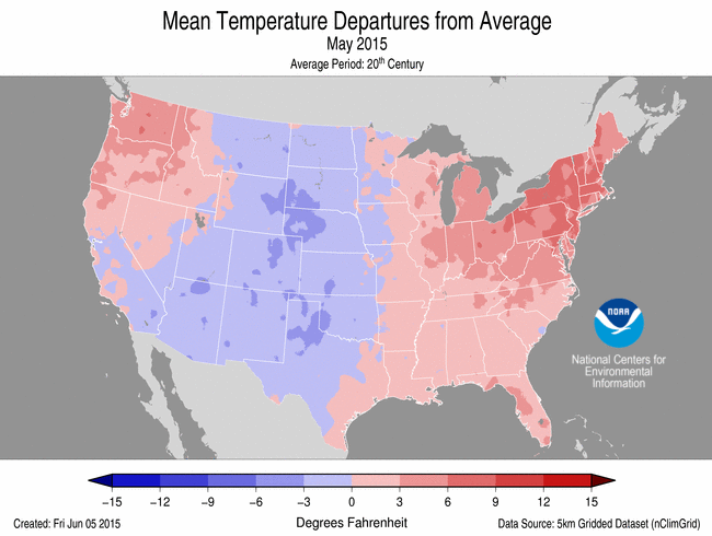 May Average Temperature Departures |
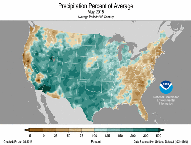 May Percent of Average Precipitation |
- Climate Highlights — May
- The May 2015 contiguous U.S. average temperature was 60.8°F, 0.6°F above the 20th century average. This was near the median value in the 121-year period of record. The May contiguous U.S. maximum (daytime) temperature was 72.5°F, 0.4°F below average. The May contiguous U.S. minimum (nighttime) temperature was 49.1°F, 1.6°F above average and the 17th warmest on record.
- Above-average temperatures were widespread in the East, where 15 states were much warmer than average. Connecticut, Massachusetts, New Hampshire and Rhode Island were each record warm, driven largely by warm daytime temperatures. In the Pacific Northwest, Washington was also much warmer than average.
- Below-average temperatures spanned the Great Plains and Southern Rockies. Daytime temperatures across the Central and Southern Plains and Southern Rockies were much below average with four states having a top 10 cold May maximum temperature. The above-average precipitation in the region kept daytime temperatures suppressed.
- The Alaska statewide average temperature for May was the warmest on record in 91-years of record keeping at 44.9°F, 7.1°F above average. The statewide maximum temperature was 8.1°F above average and the minimum temperature was 6.0°F above average; both were record warm. The previous warmest May for Alaska occurred in 2005. The warmth in Alaska was widespread with several cities being record warm, including Barrow and Juneau. The Alaska May precipitation total was 1.68 inches, 0.43 inch below average, and the 16th driest May on record.
- The May precipitation total for the contiguous U.S. was 4.36 inches, 1.45 inches above average. This was the wettest May on record and the all-time wettest month in 121-years of record keeping. The previous wettest May was in 1957 when 4.24 inches of precipitation was observed. The previous wettest month was October 2009 when 4.29 inches of precipitation was observed.
- Wetter than average conditions were widespread across the central United States. Fifteen states from the Great Basin to Mississippi River had precipitation totals that were much above average. Colorado, Oklahoma, and Texas were each record wet for the month. In fact, Oklahoma and Texas each had their wettest month of any month on record with precipitation totals more than twice the long-term average.
- The Oklahoma May precipitation total of 14.06 inches bested the previous wettest May of 1957 by 3.52 inches and the previous wettest month of October 1941 by 3.31 inches. The Texas May precipitation total of 8.93 inches bested the previous wettest May of 1914 by 2.31 inches and the previous wettest month of June 2006 by 2.27 inches.
- The heavy precipitation during May essentially ended the multi-year drought that has plagued the Southern Plains since 2011. At the beginning of June, only 0.6 percent of Texas and 0.0 percent Oklahoma were in drought. This was the first time since 2010 that the drought footprint in both states has been this low. Although long-term (60+ months) precipitation deficits persist in some locations, some reservoirs have returned to above-average levels after being record and near-record low for the past several years.
- The heavy rains in the central U.S. were accompanied by severe weather with over 400 preliminary tornado reports, the most since April 2011. The flooding rains and severe weather resulted in dozens of fatalities and widespread property damage.
- Much of the East Coast was drier than average, despite the record high contiguous U.S. precipitation value and despite tropical storm Ana making landfall in the Carolinas early in the month. Seven states from the Southeast to New England had May precipitation totals that were much below average. No state was record dry.
- According to NOAA data analyzed by the Rutgers Global Snow Lab, the May snow cover extent for the contiguous U.S. was 39,000 square miles, 25,000 square miles below the 1981-2010 average. This was the 18th smallest May snow cover extent for the contiguous U.S. and the smallest since 2012. The Alaska May snow cover extent was 161,000 square miles below average and the smallest May snow cover extent on record for the state. The entire state had below-average snow cover during the month. Looking further back at the entire snow season in Alaska, Anchorage only observed 25.1 inches of snow from September through May, the least snowy snow season record. The previous lowest seasonal snowfall for Anchorage was 30.4 inches in 1957/58 and normal is 74.5 inches.
- Tropical Storm Ana made landfall near Myrtle Beach, South Carolina on May 10th with sustained winds of 45 mph and gusts exceeding 60 mph. The winds and high surf caused severe beach erosion in parts of the Carolinas. After landfall, the storm moved to the northeast across coastal North Carolina and Virginia where precipitation totals exceeded six inches. Tropical Storm Ana is the second earliest landfalling tropical cyclone on record for the United States. Only the Groundhog Day tropical storm that struck Florida in February 1952 was earlier.
- According to the June 2nd U.S. Drought Monitor report, 24.6 percent of the contiguous U.S. was in drought, down from 37.4 percent at the end of April and the smallest drought footprint since February 2011. Drought conditions drastically improved across the Southern Plains. Drought improvement was also observed across the Central and Northern Plains, Upper Midwest, and the Central Rockies. Drought conditions developed and worsened across parts of the Northeast, Southeast, Northwest, and Puerto Rico. Drought conditions remained entrenched in the West.
- During May, there were 3,030 record warm daily high (837) and low (2,193) temperature records, which is a little more than the 2,400 record cold daily high (1,813) and low (587) temperature records.
- Based on NOAA's Residential Energy Demand Temperature Index (REDTI), the contiguous U.S. temperature-related energy demand during May was 60.9 percent below average and the 23rd lowest in the 1895-2015 period of record.


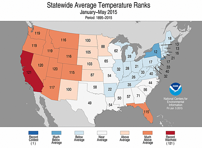
May 2015 Statewide Temperature and Precipitation ranks
- Climate Highlights — spring (March–May)
- The March-May 2015 contiguous U.S. average temperature was 53.2°F, 2.2°F above the 20th century average, the 11th warmest spring on record for the contiguous United States. The spring contiguous U.S. maximum (daytime) temperature was 65.4°F,2.2°F above average, the 14th warmest on record. The spring contiguous U.S. minimum (nighttime) temperature was 40.9°F, 2.2°F above average, the sixth warmest on record.
- Much of the contiguous U.S. was warmer than average during spring, except the Southern Plains and the Northeast. The Southeast and West were especially warm, particularly due to warm nighttime temperatures. Eleven states had mean temperatures that were much warmer than average, while 16 states had minimum temperatures that were much above average.
- Florida had its warmest spring on record, with a temperature of 74.1°F, 4.6°F above average, and 1.1°F warmer than the previous record that occurred in 2012. The Florida spring maximum temperature was 3.6°F above average, the second highest on record. The Florida spring minimum temperature was 5.8°F above average, besting the previous record by 1.2°F.
- Alaska had it fourth warmest spring with a statewide temperature that was 5.6°F above average and the warmest since 1998. The statewide maximum temperature was record high at 5.9°F above average while the minimum temperature was the fourth warmest at 5.4°F above average.
- Similar to May, above-average spring precipitation was observed across the Central and Southern Plains. Arkansas, Colorado, Kansas, Louisiana, and Oklahoma were much wetter than average. Texas had its wettest spring on record with 16.34 inches of precipitation, 8.95 inches above average, and 1.59 inches above the previous record set in 1957.
- Below-average precipitation was observed along both coasts — California, Connecticut, Massachusetts, New Hampshire, New York, Rhode Island, and Vermont were much drier than average. No state was record dry.
- Based on REDTI, the contiguous U.S. temperature-related energy demand during spring was 27.0 percent below average and the 26th lowest in the 1895-2015 period of record.
- The U.S. Climate Extremes Index (USCEI) for spring was slightly below average. On the national-scale, extremes in warm maximum and minimum temperatures and days with precipitation were much above average. Regionally, the CEI was elevated in the West due to warm daytime and nighttime temperatures and the spatial extent of drought. In the South, extremes in days with precipitation were the second highest on record. In the Southeast, extremes in warm nighttime temperature were the sixth highest on record. The USCEI is an index that tracks extremes (falling in the upper or lower 10 percent of the record) in temperature, precipitation and drought across the contiguous United States.


March-May 2015 Statewide Temperature and Precipitation ranks
- Climate Highlights — year-to-date (January–May)
- The January-May 2015 contiguous U.S. average temperature was 45.1°F, 1.8°F above the 20th century average, the 17th warmest year-to-date on record for the contiguous United States. The year-to-date contiguous U.S. maximum (daytime) temperature was 56.8°F, 1.8°F above average, the 16th warmest on record. The year-to-date contiguous U.S. minimum (nighttime) temperature was 33.4°F, 1.7°F above average, also the 16th warmest on record.
- Much-warmer-than-average conditions were observed from the Rockies to the West Coast and in Florida. In total, 11 states had year-to-date temperatures that were much above average. California was record warm for the five-month period with a temperature 5.1°F above average and 0.1°F warmer than the previous record set just last year.
- Below-average temperatures were observed in the Midwest and Northeast, particularly nighttime temperatures, where New York was the only state that had a much-cooler-than-average year-to-date temperature. The statewide average temperature was 31.0°F, 2.7°F below the 20th century average and the 12th coldest on record and coldest since 1994. New York had its second coldest January-May minimum temperature 3.8°F below average and the coldest since 1934.
- The year-to-date contiguous U.S. precipitation total was 12.91 inches, 0.52 inch above the 20th century average, and ranked among the wettest third of the historical record.
- Above-average precipitation was observed across the Great Plains and the Southern Rockies, where five states were much wetter than average. Texas had its wettest year-to-date on record with 20.11 inches, 9.63 inches above average, and 2.37 inches above the previous record set in 1957. Below-average precipitation was observed across the West and the Northeast. California had its fifth driest start to the year with 6.21 inches of precipitation, 7.62 inches below average. New York had its third driest with 11.63 inches of precipitation, 3.75 inches below average. Six addition states in the Northeast were much drier than average.
- Based on REDTI, the contiguous U.S. temperature-related energy demand during January-May was 3.6 percent above average and the 57th highest in the 1895-2015 period of record.
- The USCEI for the year-to-date was 30 percent above average and the 19th highest value on record. On the national scale, the components that measure extremes in warm maximum and minimum temperatures and days with precipitation were much above average. Regionally, the West had its record highest CEI for the year-to-date due to elevated extremes in warm daytime and nighttime temperatures, the spatial extent of drought, and days without precipitation. The Northwest had its third highest CEI due to warm daytime and night time temperatures and 1-day precipitation totals. Extremes in cold nighttime temperatures were elevated in the Northeast, while 1-day precipitation totals were high in the Northern Rockies and Plains.

January-May 2015 Statewide Temperature and Precipitation ranks
**A comparison of the national temperature departure from average as calculated by NCDC's operational dataset (nClimDiv), the U.S. Historical Climatology Network (USHCN), and the U.S. Climate Reference Network (USCRN) is available on our National Temperature Index page.**
Regional Highlights:
These regional summaries were provided by the six Regional Climate Centers and reflect conditions in their respective regions. These six regions differ spatially from the nine climatic regions of the National Climatic Data Center.
- Northeast Region: (Information provided by the Northeast Regional Climate Center)
- May was quite a mild month for the Northeast. The region's average temperature of 59.5 degrees F (15.3 degrees C) was 3.3 degrees F (1.8 degrees C) above normal, making it the 11th warmest May since recordkeeping began. Ten of the twelve Northeast states ranked the month among their top 13 warmest Mays: 6th warmest in Connecticut; 9th warmest in Massachusetts, New Jersey, New York, and Vermont; 10th warmest in Maryland, Pennsylvania, and Rhode Island; 12th warmest in New Hampshire; and 13th warmest in Delaware. Departures ranged from 1.7 degrees F (0.9 degrees C) in Maine to 4.1 degrees F (2.3 degrees C) in New York. Seven of the region's 35 major airport climate sites had record-warm Mays: Binghamton, NY; Rochester, NY; Scranton, PA; Washington National, DC; Concord, NH; Burlington, VT; and Hartford, CT. With a cool March, variable April, and warm May, the spring season averaged out to be cooler than normal for ten of the twelve states. The region's average temperature of 44.8 degrees F (7.1 degrees C) was 0.8 degrees F (0.4 degrees C) colder than normal. State departures ranged from 1.8 degrees F (1.0 degree C) colder than normal in Maine to 0.6 degrees F (0.3 degrees C) warmer than normal in West Virginia.
- The Northeast saw well below-normal precipitation during May. The region received 2.14 inches (54.36 mm), 53 percent of normal, making it the 9th driest May on record. Massachusetts and Rhode Island had record-dry Mays, while Connecticut and New Jersey had their 2nd driest Mays. New Hampshire had its 9th driest May, followed by Delaware with its 10th driest May and West Virginia with its 13th driest May. New York and Pennsylvania ended the month with their 18th driest May and 19th driest May, respectively. Departures for the states ranged from 14 percent of normal precipitation in Rhode Island to 73 percent of normal in Maine. Three of the region's 35 major airport climate sites had record-dry Mays, as well: Islip, NY; Kennedy Airport, NY; and Worcester, MA. The month also ranked among the top 15 driest of all-time for the three sites. Generally dry conditions during March, April, and May made for an overall dry spring. The region saw 8.47 inches (215.14 mm), 75 percent of normal, making it the 9th driest spring on record. Eight of the twelve states ranked the season among their top 17 driest springs: 2nd driest in Connecticut and Massachusetts, 4th driest in New Hampshire, 5th driest in New York and Vermont, 8th driest in Rhode Island, 14th driest in New Jersey, and 17th driest in Maine. State departures ranged from 47 percent of normal in Connecticut and Massachusetts to 111 percent of normal in West Virginia.
- At the beginning of May, 50 percent of the Northeast was abnormally dry. A continuing lack of precipitation and extremely low stream flows contributed to moderate drought being introduced in parts of the region in the U.S. Drought Monitor issued on May 21. By month's end, 47 percent of the region was abnormally dry, while 24 percent of the region was experiencing moderate drought conditions. USDA crop reports indicated that plant growth was slow due to lack of moisture, with some farmers already irrigating and other farmers delaying planting until rain fell. Dry conditions also contributed to numerous wildfires across the region, including a fire that burned around 2,600 acres in Sullivan and Ulster counties in New York.
- Severe weather struck the region numerous times in May. Winds of up to 70 mph (31 m/s) caused damage, while heavy rain triggered flash flooding. Golf-ball size hail was also reported. On May 31, an EF-0 tornado touched down in Mercer County, Pennsylvania.
- For more information, please go to the Northeast Regional Climate Center Home Page.
- Midwest Region: (Information provided by the Midwest Regional Climate Center)
- Average temperatures for the month of May ranged from the lower to upper 50s F (10 to 15 degrees C) across Minnesota, Wisconsin, northwest Iowa, and the northern half of Michigan, and gradually warmed to the 60s F (16 to 21 degrees C) across southeast Iowa, southern Michigan, Missouri, Illinois, Indiana, and Ohio. Southeast Missouri, roughly the southern halves of Illinois, Indiana, and Ohio, and all of Kentucky observed average temperatures in the upper 60s F (18 to 21 degrees C). Average temperatures were predominantly 1 to 5 degrees F (0.6 to 2.8 C) above average east of the Mississippi River and 2 to 3 degrees F (1.1 to 1.7 C) below normal heading west from the Mississippi River. Northeast Ohio observed average temperatures for the month 6.0 degrees F (3.3 C) above normal. The monthly average maximum temperatures for the region followed a similar distribution to the average observed temperature, with warmer temperatures in the eastern half of the region. Monthly average minimum temperatures were 2 to 5 degrees F (1.1 to 2.8 C) warmer than normal across much of the region, with western Iowa and Minnesota experiencing normal average minimum temperatures for the month of May. Overall, the region experience its 53rd warmest May on record (1895-2015), only 0.1 degrees F (0.1 C) above normal (59.4 degrees F (15.2 C)). The warmest state was Ohio with an average temperature 3 degrees F (1.7 C) above normal making May 2015 the 21st warmest May on record. The coldest state, with a departure of 2.3 degrees F (4.1 C) below normal, was Minnesota - ranking 43rd coldest on record. A warm spell over the eastern half of the region broke many daily maximum high temperature records when high temperatures climbed into the mid and upper 80s F (degrees F, 28 to 32 C) May 7th - 11th. A cold spell over the region May 19th - 22nd broke many daily minimum low temperature records with average daily minimum temperatures around 35 degrees F (1.7 C) and brought frost to the northern latitudes of the region.
- May brought over five inches (127 mm) of precipitation across much of Minnesota, central Wisconsin, and portions of Iowa, Illinois, northwest Indiana, and all of Missouri. Western and southwest Missouri recorded seven and a half inches (191 mm) or more of precipitation. Other locations in the region observed between two to five inches (51 to 127 mm) of rain with the driest areas being southern Ohio and eastern Kentucky where only one to two inches (25 to 51 mm) of rain fell. This pattern provided 100 percent of normal rainfall to much of the region except for the southern half of Indiana, the southern two-thirds of Ohio, and the eastern two-thirds of Kentucky. These portions only received 25 to 75 percent of normal rainfall. Therefore, the southeast portion of the Midwest region saw rainfall of zero to four inches (0 - 102 mm) below normal, while the remaining part of the region except for some isolated areas in Iowa, southeast Wisconsin, and the thumb of Michigan saw rainfall two to four inches (51 - 102 mm) above normal. The Midwest region was 0.14 inches (4 mm) below normal for May having observed 4.06 inches (103 mm) of precipitation. The wettest state as a departure from normal was Minnesota with May 2015 ranking 15th wettest on record for the state. Minnesota observed 4.80 inches (122 mm) of precipitation, with May's normal precipitation being 3.19 inches (81 mm). The driest state, experiencing close to a three inch (76 mm) deficit of rainfall was Kentucky. May 2015 experienced only 2.39 inches (61 mm) of rain, 2.90 inches (74 mm) below normal. It was Kentucky's 13th driest May on record.
- A split weather pattern of drier and warmer weather in the northwest part of the Midwest region and wetter weather across the southeast portion of the Midwest region in late April and early May allowed many farmers across the northwest states to get into the fields earlier than average and complete planting. Much of the region was above the 5-year average for corn planting. Minnesota and Wisconsin were the states to benefit the most form the drier and warmer weather pattern before heavier rain events came later in May, having 100 percent and 85 percent of the crop planted across the states, respectively, by the week ending on May 17th, 2015. This was roughly 60 to 70 percent greater than the 5-year average. The wetter conditions in the southeast portion of the region delayed planting some, but all states remained ahead of the 5-year average planting dates. Soybean planting in Minnesota was also much ahead of schedule, with 88 percent of the crop planted, with the 5-year average of 59 percent by this time of year. Remaining states had 60 to 76 percent of soybeans planted by May 26th, with Missouri only at 20 percent planted.
- May was an active severe weather month across the Midwest region. Tornado and wind events were the predominant reports. On May 10th -11th, wind damage was reported in southern Illinois and southeastern Missouri, and a confirmed EF-1 tornado moved through Lake City and Rockwell City, IA. The system progressed eastward May 11th, resulting in winds of 50 to 70 miles per hour (81 to 113 kilometers per hour) across eastern parts of Indiana and Kentucky as well as most of Ohio. Northeastern Ohio was hit particularly hard with reports of mobile homes sustaining major damage. May 15th -17th was another active period. Strong thunderstorms formed on May 15th across Missouri into central Illinois and then across eastern Indiana as the system progressed eastward. The most severe storms developed on May 16th as the main low pressure system organized in the eastern Dakotas. Wind damage was reported from Iowa through Missouri with embedded EF-0 and EF1 tornadoes in storms that fired along the cold front. Closer to the main low, tornadoes formed in central and western Minnesota. Preliminary reports from the National Weather Service-Chanhassen identified 15 separate tornadoes. May 17th brought Wisconsin its first tornado of the year. Additional severe weather events with wind and tornado reports occurred on May 24th (Iowa, Missouri, and Illinois), May 26th (Wisconsin, Illinois, and Ohio), and May 30th (Indiana).
- A wetter period from May 8th -21st brought some much needed rainfall to Minnesota, downgrading moderate drought conditions to abnormally dry conditions in much of Minnesota and Wisconsin according to the U.S. Drought Monitor.
- For details on the weather and climate events of the Midwest, see the weekly summaries in the Midwest Climate Watch page.
- Southeast Region: (Information provided by the Southeast Regional Climate Center)
- Mean temperatures in May were slightly above average across much of the Southeast region. The greatest departures were found across Virginia and portions of Florida and western North Carolina, where monthly temperatures were 4 to 7 degrees F (2.2 to 3.9 degrees C) above average. Washington, DC (1872-2015) observed its warmest May mean temperature on record, and Tallahassee, FL (1893-2015) observed its second warmest mean temperature for May on record. The unusually warm conditions were also quite persistent during May at these locations. For example, the daily maximum temperature in Washington, DC was 80 degrees F (26.7 degrees C) or higher for 22 days during the month, ranking this May first in its 143-year period of record. In addition, Tallahassee, FL recorded four consecutive days (9th through the 12th) with a maximum temperature of at least 95 degrees F (35 degrees C), which is tied for the eighth longest streak prior to May 31st. Mean temperatures were also above average in Puerto Rico and the U.S. Virgin Islands. Both Guayama, PR (1914-2015) and Juncos, PR (1931-2015) observed their warmest mean temperature for May on record. The warmest weather of the month occurred on the 11th and 12th, as moist tropical air surged northward ahead of an approaching cold front. During this two-day period, maximum temperatures reached the upper 80s F (30.6 to 31.7 degrees C) to lower 90s F (32.8 to 33.9 degrees C) across the entire region, with portions of Florida recording temperatures in the middle 90s F (34.4 to 35.6 degrees C). In contrast, the coolest weather of the month occurred on the 2nd, as a modified Arctic high pushed southward across the region. Daily minimum temperatures remained below 50 degrees F (10 degrees C) across a large portion of the region, with temperatures dropping into the upper 30s F (2.8 to 3.9 degrees C) in portions of western North Carolina and Virginia.
- Precipitation was generally below normal across the Southeast during May, with isolated pockets of wetness in some locations. The driest locations were found across Virginia, central portions of the Carolinas, coastal Georgia, and eastern Florida. Monthly precipitation totals in these areas were 2 to 4 inches (50.8 to 101.6 mm) below normal, or 50 to as little as 5 percent of normal. Charlotte, NC (1879-2015) and Moultrie, GA (1926-2015) observed their third driest May on record with only 0.32 (8.1 mm) and 0.46 inch (11.7 mm) of precipitation, respectively. In addition, only one day of measurable precipitation was recorded in Charlotte during the month, which ties for the fewest number of days during May with measurable precipitation at this location. The wettest locations were found in localized areas of coastal North Carolina, southern Alabama, and western Florida, where monthly precipitation totals exceeded 200 percent of normal. The passage of Tropical Storm Ana on the 11th resulted in Kinston, NC (1900-2015) observing its wettest day on record for May with 4.80 inches (122 mm) of precipitation. Precipitation was below normal for much of Puerto Rico and the U.S. Virgin Islands during May. Guayama, PR observed its driest May on record with only 0.27 inch (6.9 mm) of precipitation, and Juncos, PR observed its second driest May on record with 1.01 inches (25.7 mm) of precipitation.
- There were 209 severe weather reports across the Southeast during May, and over 80 percent of these reports were for damaging thunderstorm winds. At least one severe weather report was recorded within the region on 21 days during the month, but nearly 40 percent of these reports were associated with severe weather outbreaks that occurred on just two days during May (11th and 26th). On the 21st, a thunderstorm microburst with maximum wind speeds estimated at 90 mph caused significant damage to trees and one home in Duplin County, NC. Only four tornadoes (2 EF-0s, 2 EF-1s) were confirmed across the Southeast in May, which is surpassed by only five other years since 1950 with less than four May tornadoes according to the SPC severe weather database. On the 11th, an EF-0 waterspout spawned by Tropical Storm Ana moved onshore and caused minor tree damage near the town of Manteo in Dare County, NC. Ana made landfall near Myrtle Beach, SC during the morning of May 10th, making it the earliest landfalling tropical storm on record along the South Carolina coastline. The highest wind gusts associated with Ana exceeded 60 mph and were recorded at Southport, NC as well as the Frying Pan Shoals buoy off of Cape Fear, NC. Another EF-0 waterspout came onshore at Fort Lauderdale Beach, FL on the 25th of the month. An inflatable bounce house located on the beachfront was lifted approximately 20 feet into the air, injuring three children who were inside the house and one adult nearby. On the 13th, two construction workers were injured by a lightning strike while working on a residential rooftop in Bonita Springs, FL.
- A modest change in drought conditions was observed across the region during May. The percentage of the region under drought-free conditions (less than D1) decreased slightly from approximately 99 percent on May 5th to 98 percent on May 26th. Moderate (D1) drought conditions expanded across far southern Florida, and a small area of moderate drought developed near Valdosta in south-central Georgia. The unusually warm and dry conditions during May contributed to numerous agricultural impacts throughout the region. Peanut planting in Georgia was aided by dry conditions at the beginning of the month, but recent dryness prevented any significant growth in the crop. Despite a late frost across southern Georgia in late March, the persistent warmth during May helped the peach crop develop quickly, leading to a favorable harvest of small but sweet fruit.
- For more information, please go to the Southeast Regional Climate Center Home Page.
- High Plains Region: (Information provided by the High Plains Regional Climate Center )
- Sometimes when it rains it pours, and that is exactly what happened across portions of the central and western U.S. this May. Widespread heavy rainfall in excess of 200 percent of normal not only led to the reduction or removal of drought conditions, but in many cases, extensive flooding. Southern Oklahoma was hit particularly hard with widespread monthly totals that were well over 12.00 inches (305 mm) above normal. Here in the High Plains region, the highest precipitation amounts occurred in Kansas where 12.00-15.00 inches (305-381 mm) of precipitation fell over the course of the month, which led to surpluses in excess of 6.00 inches (152 mm). Heavy rainfall was not the only story, however. The Mother's Day Snowstorm brought heavy snows to parts of eastern Wyoming, western Nebraska, and the Black Hills of South Dakota causing some locations to rank in the top 10 snowiest Mays on record. This month was quite a contrast to the past few months with the pattern switching from very dry to very wet. South Dakota was a dramatic example as it went from having its driest start to any year (January through April) to having its 7th wettest May on record (please note that statewide precipitation data are preliminary and subject to change). Another dramatic example comes from western Kansas, which had been experiencing drought for years, but is now almost completely drought free. It is worth noting that in some areas of drought recovery, some lingering drought impacts remain. While precipitation was the big story this month, there were some notable impacts due to temperatures. Overall, temperatures were below normal this month and the mercury dipped below freezing on a few untimely occasions. In Kansas, a freeze event at the beginning of the month hit while wheat was in its flowering stage, making it more vulnerable to freeze damage. The crop is still being assessed for damage at this time. In the middle of the month, a freeze event in South Dakota caused minimal damage to wheat, while a late-month freeze event in North Dakota damaged some canola fields there. A better assessment of the damage to these crops will be available in June.
- It was a cool month for the High Plains region. A large area across central portions of the region had monthly temperature departures of at least 2.0 degrees F (1.1 degrees C) below normal. Embedded within this area, temperature departures of 4.0-6.0 degrees F (2.2-3.3 degrees C) below normal were common in eastern Wyoming, western South Dakota, the panhandle of Nebraska, and eastern Colorado. Due to these cool conditions, a few locations ranked in the top 20 coolest Mays on record, including Denver, Colorado (12th), Pueblo, Colorado (12th), Rapid City, South Dakota (13th), Laramie, Wyoming (14th), Scottsbluff, Nebraska (15th), and Pierre, South Dakota (19th). Although monthly temperatures were not record breaking, there were some notable daily records this month. Unseasonably cold temperatures during the last weekend of the month appear to have caused frost damage in areas of northern North Dakota. At the beginning of June, there were reports of frost damage to canola in the Wales area. It will take some time, however, to assess the full extent of the damage. North Dakota's neighbor to the north, Manitoba, Canada, was also hit as many fields of canola were damaged completely. According to Reuters, this damage caused canola prices to spike. Stations from the North Dakota Agricultural Weather Network (NDAWN) confirm that temperatures were below freezing for several hours in the early morning hours of the 30th.
- May was an extremely wet month for the High Plains region with widespread precipitation totals ranging between 200 and 400 percent of normal. A few isolated areas even received greater than 400 percent of normal precipitation. Only two areas of the region were below normal - western North Dakota and central through northeastern Nebraska. The wet weather led to numerous records across the region. Many locations had their wettest May on record and a few ranked in the top 10 snowiest Mays on record as well. A sampling of locations having their wettest May included Colorado Springs and Pueblo in Colorado, Lincoln and Scottsbluff in Nebraska, and Fargo, North Dakota. One example of the heavy rainfall comes from Lincoln, Nebraska, which received 10.90 inches (277 mm) of precipitation this month. Over half of this monthly total fell in about an 8-10-hour stretch during the evening and overnight hours of May 6-7. The 2-day total of 6.73 inches (171 mm) was the highest 2-day total for May and the second highest 2-day total for any month on record for Lincoln, with reports dating back to 1887. Some Community Collaborative Rain, Hail, and Snow Network (CoCoRaHS) stations across the city received over 7.00 inches (178 mm) of rain. The heavy nature of the event combined with the short duration caused flooding to occur throughout the city. The heavy rain and flooding was not confined to Lincoln, however, as residents in portions of Lancaster, Saline, and Jefferson Counties were evacuated from the rising floodwaters. Several locations in these counties reported rainfall totals over 9.00 inches (229 mm) with the highest amount of 10.47 inches (266 mm) occurring at the Fairbury 11.4 NW CoCoRaHS site. That much rain over about an 8 hour period translates into approximately a 1 in 1000 year event. The heavy rain was quite widespread this month and flooding issues were not confined to Nebraska. For example, at the end of the month, Governor Brownback of Kansas declared 44 counties as disaster areas due to storms and flooding. The heavy rain has not just impacted roadways and buildings, but has also caused problems for producers as planting and haying activities have been delayed in several areas due to wet field conditions. The excessively wet conditions have also allowed for an increase in insect and disease issues for crops, especially in Kansas, Nebraska, and South Dakota. Leaf rust, stripe rust, and head scab in wheat have been the major issues. Additionally, fertilizer applications have been disrupted or even lost due to the heavy rains.
- Heavy precipitation greatly improved drought conditions this month, according to the U.S. Drought Monitor. The total area in drought (D1-D4) across the High Plains region decreased from about 44 percent to just under 7 percent. South Dakota and Kansas experienced the largest changes over the past month, decreasing their drought coverage area by 68 percent and 62 percent, respectively. All extreme drought conditions (D3) have been erased from the region and only a small area of severe drought (D2) remains in eastern South Dakota. Colorado, Kansas, Nebraska, and Wyoming have some areas of abnormally dry (D0) or moderate drought conditions (D1) remaining, while North Dakota is now drought free, with areas of D0 in the east and west. Precipitation outlooks for the region indicate that these dry areas will continue to improve over the summer. The only areas to degrade included small areas of western North Dakota and northwestern Wyoming, where D0 developed.
- For more information, please go to the High Plains Regional Climate Center Home Page.
- Southern Region: (Information provided by the Southern Regional Climate Center)
- Heavy precipitation greatly improved drought conditions this month, according to the U.S. Drought Monitor. The total area in drought (D1-D4) across the High Plains region decreased from about 44 percent to just under 7 percent. South Dakota and Kansas experienced the largest changes over the past month, decreasing their drought coverage area by 68 percent and 62 percent, respectively. All extreme drought conditions (D3) have been erased from the region and only a small area of severe drought (D2) remains in eastern South Dakota. Colorado, Kansas, Nebraska, and Wyoming have some areas of abnormally dry (D0) or moderate drought conditions (D1) remaining, while North Dakota is now drought free, with areas of D0 in the east and west. Precipitation outlooks for the region indicate that these dry areas will continue to improve over the summer. The only areas to degrade included small areas of western North Dakota and northwestern Wyoming, where D0 developed.
- With the exception of Tennessee, May was an extremely wet month across the Southern Region, with historically high precipitation totals at both the station and state level. The wettest portions on the region included most of southern Oklahoma and northern Texas, where stations saw as much as 28 inches (711.2 mm) of rainfall for the month. In the South Central Climate Division of Oklahoma, several stations reported over 20 inches (508.0 mm) for the month. Similarly, stations in the North Central Climate Division of Texas consistently reported well over 10-11 inches (254.0-279.4 mm). The state-wide average precipitation totals for the month are as follows with: Arkansas reporting 10.35 inches (262.89 mm), Louisiana reporting 8.12 inches (206.25 mm), Mississippi reporting 6.02 inches (152.91 mm), Oklahoma reporting 14.06 inches (357.12 mm), Tennessee reporting 3.65 inches (92.71 mm), and Texas reporting 8.93 inches (226.82 mm). The value of 8.93 inches (226.82 mm) for Texas was not only the wettest May on record, but it was also the wettest month ever, eclipsing the previous value of 6.66 inches (169.16 mm) set back in June of 2004. The state-wide average for Oklahoma was also the wettest month ever. The previous record was 10.75 inches (273.05 mm), which was set in October of 1941. For Arkansas it was the second wettest May on record, and the twelfth wettest May for Louisiana. Mississippi recorded its twenty-sixth wettest May on record. All records are based on data for the period 1895-2015. Putting this rainfall in perspective, the Southern Region averaged over eight inches (203.2 mm) of rain, that's the equivalent of an ankle deep pool of water spread over an area just over half a million square miles (1,294994 square km).
- Historic May rainfall totals in Oklahoma and Texas have resulted in a tremendous improvement of drought conditions in both states. As of June 2, 2015, only 0.32 percent of the Southern Region is in drought, with no states showing any severe (D2), extreme (D3) or exceptional (D4) drought conditions. The May 19th United States Drought Monitor marked the first time since June 22, 2010 that there was no extreme or exceptional drought in the Southern Region. It was also the first time since November 23, 2010 for Texas, and the first time since March 8, 2011 for Oklahoma, that the drought map for each state was not showing any D3/D4 drought.
- In Texas, state reservoirs now stand at 83.3% full which is a 10% jump since the start of the month. Dallas-area reservoirs increased from 64% of capacity in March to more than 95% of capacity. Wichita Falls ended the month under a Stage 2 water restriction, having started under Stage 5 Drought Catastrophe. Not all of the state saw the same improvements, however, as both Abilene and San Angelo are sitting at near record low reservoir storage — 12 and 22 percent of capacity, respectively. Agriculturally, the flooding that has occurred across multiple parts of the state has washed out a lot of crops. In the Rio Grande Valley, some farmers are saying that their entire summer batch of squash has been washed completely out. This problem stretches all across the state since flooding has been a big issue throughout the month. Other crops that are still being planted, such as cotton, are behind schedule due to the extreme rainfall and saturation of soils across the state; cotton planting is 10 percent behind the last several years' average. Despite the problems with saturated topsoil, the recent rains did much to ease the subsoil moisture loss from the last several years, as now only 5% of croplands are short or very short. Ecologically, cattle have an abundance of water from the rains, and pastures and rangeland improved such that only 5% are poor or very poor and 72% are good or excellent (Information provided by the Texas Office of State Climatology).
- According to CBS News in Houston, twenty-one people have died there as a result of flash flooding that devastated the city on Memorial Day weekend. Eleven more people are still reported missing. The rainfall occurred overnight on May24-25. Rainfall totals over 11 inches (279.4 mm) were reported at CoCoRaHS stations throughout the city. The hardest hit areas included the Sugarland and Richmond areas. This storm is being referred to as a one-hundred year flood. The total damage of the storm won't be tallied up for some time, but the storm brought the city to a stand still, flooding interstate highways, homes and leaving thousands of people without power.
- For more information, please go to the Southern Regional Climate Center Home Page.
- Western Region: (Information provided by the Western Region Climate Center)
- The West saw a transition to a more active atmospheric pattern this month. Several slow-moving low-pressure systems passed through the region bringing widespread above normal precipitation to the Great Basin, Desert Southwest, and the Central and Southern Rocky Mountain states. Below normal temperatures accompanied the storminess.
- Trajectories of low pressure systems across the southern Great Basin favored easterly winds directed at the eastern slope of the Sierra Nevada, facilitating well above normal precipitation in this area. Parts of eight western states experienced their record wettest May. Bodie, California, noted its wettest May on record with 6.06 in (154 mm), 866% of normal, surpassing by 79 % the previous record of 3.38 in (86 mm) in 1995. Bodie also recorded its wettest May day on record, 1.67 in (42 mm) on the 8th; records began in 1895. Over two feet of late season snow fell in the high Sierra Nevada during the month, providing a small addition to the nearly non-existent snowpack. Slow-moving systems brought precipitation and thunderstorms to other parts of the Great Basin and Southwest as well. Tonopah, Nevada, and Rome, Oregon, each saw their wettest May on record at 2.44 in (62 mm) and 3.48 in (88 mm), respectively. Records began in 1902 at Tonopah and 1949 in Rome. In the eastern Great Basin, Cedar City, Utah, recorded its 2nd wettest May in a 68-year record at 3.12 in (79 mm), 405% of normal. In the Southwest, Phoenix, Arizona, observed its wettest May in an 83-year record at 1.17 in (30 mm). Precipitation in these areas increased soil moisture, reduced irrigation demands, and supported vegetation growth. However, it did not reduce the persistent hydrologic drought in California, Nevada, and southern Oregon. Above normal rainfall was observed in central Washington as well, where Yakima logged 1.8 in (46 mm), 310% of normal, the 4th wettest May since records began in 1946. In the Rocky Mountain states, Clayton, New Mexico received 6.81 in (173 mm), 347% of normal and the 2nd wettest May since records began in 1896. In Colorado, Colorado Springs logged 8.13 in (207 mm) precipitation, 400% of normal and the wettest May in a 68-year record. This precipitation helped to ameliorate drought conditions across a large area of the Colorado-Utah-Wyoming borders, and along the eastern part of the Colorado-New Mexico border.
- Precipitation was below normal along the Pacific Coast west of the Sierra and Cascades from Los Angeles to the Canadian border and along the northern tier of the West. In northern California, Arcata received 0.1 in (3 mm), 4% of normal rainfall, tied with 2008 for driest May since records began in 1945. Further north, Quillayute, Washington, observed 0.67 in (17 mm) precipitation, only 13% of normal, the driest May in a 50-year record.
- The Pacific Northwest saw above normal temperatures this month. In central Washington, the average May temperature at Yakima was was 64.9 F (18.3 C), 7.8 F (4.3 C) above normal and the 2nd warmest May in a record that began in 1946. In contrast, the rest of the West was generally 1-4 F (0.5-2 C) cooler than normal, with some departures reaching -4 to -6 F (2-3 C) in the Southwest. Douglas, Arizona, reported an average 64.9 F (18.3 C) for the month, 5 F (2.7 C) below normal and the second coldest May in a 68-year record. In Colorado, Boulder observed its 5th coolest May in a 123-year record at an average 52.4 F (11.3 C).
- May marked the end of Alaska's main snow season and end of the least snowy season on record for Anchorage, where only 25.1 in (63 cm) of snow fell September through May. The previous lowest snowfall was 30.4 in (77 cm) in 1957-58 and normal is 74.5 in (189 cm). Several locations throughout Alaska observed their warmest May on record this month including Juneau in the southeast (54.1 F/12.3 C) and Kotzebue (40.3 F/4.6 C) in the northwestern part of the state. Records for Juneau began in 1936 and for Kotzebue in 1897. Further south, as Hawaii moved into its dry season this month, precipitation was variable across the state. Kahului received 2.23 in (57 mm), 300% of normal and the 8th wettest May since records began in 1905. In contrast, Honolulu recorded only 0.2 in (5 mm), 32% of normal.
- May (all month): Severe drought persists in California/Nevada/Oregon: Despite above normal May precipitation, drought conditions remain in these states. Impacts include low spring runoff threatening fisheries and water resources, curtailment of water deliveries for agriculture, mandatory water restrictions in California, and ecological impacts on forests and wildlife.
- May 15: Washington Governor declares statewide drought emergency: Due to low snowpack, wildfire hazards, crop losses, and threats to wildlife, Washington Governor Jay Inslee declared a statewide drought emergency.
- May 30-31: Hurricane Andres forms in eastern Pacific: Andres was the 5th major hurricane to form in the Pacific Basin in May since reliable records began in 1970.
- For more information, please go to the Western Regional Climate Center Home Page.