Climate Extremes Index | Tornadoes | Tropical Cyclones | Snow
Map of U.S. Climate Regions | Map of U.S. Climate Divisions

2013 National Events Map
Click for more information
Issued January 15, 2014: The data presented in this report are preliminary. Ranks, anomalies, and percent areas may change as more complete data are received and processed.
National Temperature and Precipitation Analysis
Supplemental 2013 Temperature and Precipitation Information
- Year-to-date temperature evolution for select U.S. cities
- Year-to-date precipitation evolution for the contiguous U.S.
- 2013 U.S. Drought Improvement
- 2013 Alaska Extremes
- Select U.S. stations with extreme year
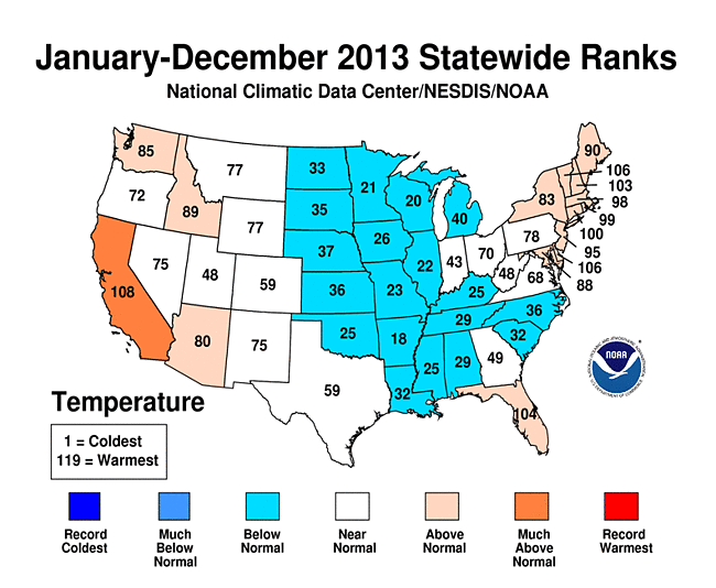
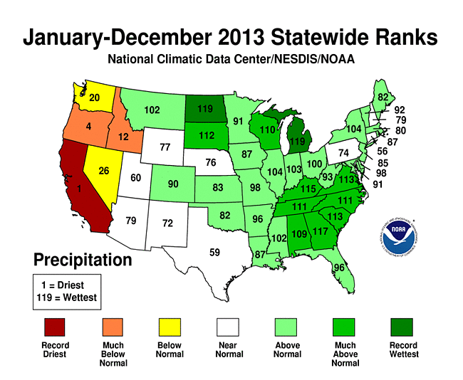
In 2013, the contiguous United States (CONUS) average temperature of 52.4°F was 0.3°F above the 20th century average, and tied with 1980 as the 37th warmest year in the 119-year period of record. The 2013 annual temperature marked the coolest year for the nation since 2009. The 2013 CONUS average temperature was 2.9°F cooler than the 2012 average temperature, which was the warmest year on record for the nation. Since 1895, when national temperature records began, the CONUS has observed a long-term temperature increase of about 0.13°F per decade. Precipitation averaged across the CONUS in 2013 was 31.17 inches, 2.03 inches above the 20th century average. This marked the 21st wettest year on record for the nation and the wettest since 2009. Compared to 2012, which was the 18th driest year on record, the CONUS was 4.50 inches wetter in 2013. Over the 119-year period of record, precipitation across the CONUS increased at an average rate of 0.17 inch per decade.
On a statewide and seasonal level, 2013 was a year of precipitation extremes, with temperature extremes being more muted than the previous year. Above-average temperatures during 2013 were observed in parts of the West, Northeast, and in Florida. No state had annual temperatures that ranked among the ten warmest. California tied its 12th warmest year with a statewide average temperature of 60.3°F, 1.4°F above average. Below-average annual temperatures were observed from the Northern Plains, through the Central Plains and Midwest, and into the Southeast. No state had annual temperatures that ranked among the ten coolest. Despite no state having a record warm or cool year, numerous locations across California and Florida had their warmest year on record, while numerous locations across the Plains and Mid-South had their coolest year on record. A map of those stations is available here. Based on NOAA's Residential Energy Demand Temperature Index (REDTI), the contiguous U.S. temperature-related energy demand during 2013 was 7 percent above average and ranked as the 49th lowest in the 1895-2013 period of record. On a local level during 2013, approximately 26,100 daily warm temperature records were tied or broken (10,100 warm daily maximum records and 16,000 warm daily minimum records); while approximately 28,800 daily cool temperature records were tied or broken (16,900 cool daily maximum records and 11,900 cool daily minimum records).
Overall, U.S. Drought Monitor, conditions improved across much of the southeastern and central U.S. during 2013, but deteriorated in the Far West and Northeast. At the end of 2013, about 31.0 percent of the contiguous U.S. was experiencing drought, down from 61.1 percent at the beginning of the year.
Seasonal highlights in 2013 included:
- The CONUS had its 20th warmest winter on record, with much of the eastern U.S. having above-average temperatures. Florida had its tenth warmest winter on record. Below-average temperatures were observed in parts of the West. The CONUS winter precipitation was above average with wetter-than-average conditions along the Gulf Coast and the western Great Lakes, where seven states had a top ten wet winter season. The winter snow cover extent for the CONUS was 15th largest on record.
- Spring temperatures were cool for the CONUS with a temperature 0.5°F below average. This marked the first season since the winter of 2010/11 with below average CONUS temperatures and this was the coldest spring since 1996. Below-average temperatures were widespread in the central and southeastern U.S., where 14 states had spring temperatures ranking among the ten coolest on record. The West and New England were warmer than average. California had its seventh warmest spring on record. Spring precipitation was near-average nationally, with above-average precipitation in the Upper Midwest and below-average precipitation in much of the West. Iowa had its wettest spring on record, in addition to five additional nearby states having a top 10 wet spring. Below-average spring precipitation was observed in the West and Mid-Atlantic. California and New Mexico had a top 10 dry spring.
- The summer CONUS temperature was above average and tied with 1937 as the 15th warmest summer on record. Above-average temperatures were present in the West and Northeast where nine states had one of the 10 warmest summers on record. Below-average temperatures were observed in the Midwest and Southeast. The summer of 2013 was the eighth wettest on record for the CONUS and the wettest since 2004. Record and near-record wet conditions were observed in the East and Southwest. New York, South Carolina, Georgia, and Florida each had their wettest summer on record.
- The CONUS was slightly warmer than average during autumn, with much of the nation having near-average temperatures. The autumn precipitation total was above average. Near-record wet conditions were observed across the High Plains and Northern Plains, where five states were top 10 wet. California had its 10th driest autumn on record.
This annual report places the temperature and precipitation averages into historical perspective, while summarizing the notable events that occurred in 2013. More detailed analysis on individual months can be found through the Climate Monitoring home page.
Seasonal Analysis
Winter


The winter season of 2012/13 was warmer than average for the contiguous U.S. with a temperature of 34.2°F, 1.9°F above the 20th century average, and the 20th warmest winter on record. Much of the winter warmth came early in the season. The December average temperature was 3.4°F above average and tied with 1994 as the 10th warmest December on record. The January and February average temperatures were both near the 20th century average. During the December 2012–February 2013 period, above-average temperatures were widespread east of the Rockies. Florida had its tenth warmest winter with a seasonal temperature 3.4 °F above average. Part of the West had near-average winter temperatures, while the Southwest and Oregon had a cooler-than-average winter season.
The 3-month average CONUS precipitation of 7.05 inches was 0.58 inch above average and the 26th wettest winter season on record. Above-average winter precipitation was widespread east of the Rockies, with the largest departures from average occurring across the Southeast and Great Lakes. Louisiana, Mississippi, Alabama, Georgia, Wisconsin, Illinois, and Michigan each had a top ten wet winter season. Below-average precipitation was present across the northwestern quadrant of the country and the West Coast. December was particularly wet across the country, with the CONUS average precipitation 0.50 inch above average marking the 20th wettest December. January and February both had near-average precipitation, masking both regional wet and dry extremes during the two months. Georgia had its wettest February on record, receiving more than twice the average monthly precipitation. This began a very wet year for the state that drastically improved the drought conditions that had plagued the state since 2010. Over the course of the season, the above-average precipitation shrank the national drought footprint from 62.4 percent at the beginning of December 2012 to 61.1 percent at the beginning of January and to 54. percent at the end of February. Most of the drought improvement occurred in the Southeast. In terms of snow cover, numerous winter storms impacted the CONUS during the three-month period. The satellite-derived snow cover extent for December 2012-February 2013 was approximately 1.3 million square miles, which was 127,000 square miles above the 1981-2010 average. This marked the 15th largest seasonal snow cover extent in the 1966-present period of record. Despite the above-average precipitation in the Great Lakes region, all of the Great Lakes had below-average water levels in January 2013 and Lakes Huron and Michigan (hydrologically the same lake) reached a new record low level in the 1918-present period of record, according to the Army Corps of Engineers.
Spring
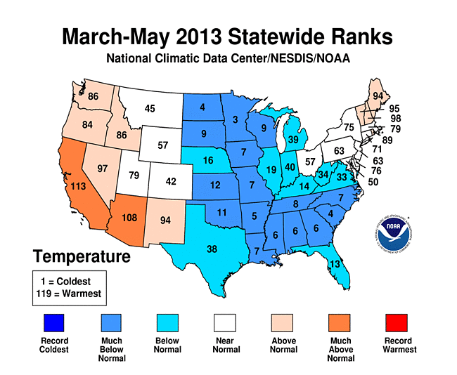
The national spring temperature of 50.4°F was 0.5°F below the 20th century average. This was the coolest spring for the nation since 1996 and in stark contrast to the spring of 2012, just one year earlier, when the U.S. experienced its record warmest spring. The spring of 2013 was 5.6°F cooler than the spring of 2012. The March temperature was 0.9°F below than average, April was 1.4°F cooler than average, and the May temperature was 0.8°F above average. The starkest contrast between 2012 and 2013 was in March, when the year-over-year difference in monthly temperature was 9.7°F. On a statewide level, below-average temperature stretched from the Upper Midwest, through the Mississippi River Valley, and into the Southeast where 14 states had seasonal temperatures ranking among the 10 coolest. Above-average temperatures were present in parts of New England and the West. California had its seventh warmest spring with a temperature of 60.5°F, 3.9°F above average.
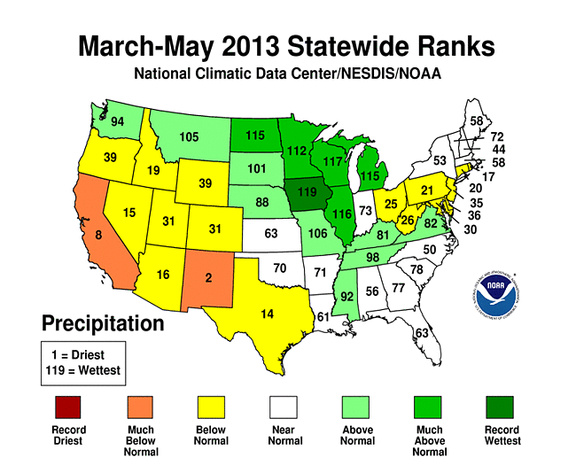
The national spring precipitation total was 0.21 inch above average at 7.92 inches, which ranked near the median value for the season. Nationally, March was drier than average and ranked as the fifth driest such month on record, April was wetter than average and the 19th wettest such month, and May was the 17th wettest on record. The national precipitation average masked both wet and dry extremes that occurred regionally during the season. The Great Lakes and Upper Midwest had a very wet spring. Six states from Michigan to North Dakota had a top 10 wet spring. Iowa was record wet with 196 percent of average precipitation for the period March-May. The Mid-Atlantic and southwestern quadrant of the country were drier than average during spring. California had its eighth driest spring with a seasonal precipitation total 41 percent of average. New Mexico had its second driest spring with a seasonal precipitation total 28 percent of average.
The wet conditions in the central U.S. resulted in several rivers in Illinois, Iowa, and Michigan reaching record high levels, with widespread flooding observed. The Mississippi River at St. Louis also reached flood stage after dropping to near-record low levels at the beginning of the year. Drought conditions during spring drastically improved in the Southeast and Midwest, remained the nearly the same across parts of the High Plains, and deteriorated in the Southern Rockies and Far West. At the beginning of the spring, the CONUS drought footprint covered 54.2 percent of the Lower-48, but contracted to 44.3 percent of the CONUS by the end of spring. Snow cover extent was above average and ranked as the eighth largest on record for the spring season. After a warmer than average winter with many locations receiving below-average snowfall, several winter storms resulted in numerous cities receiving more snowfall during the March-May period than during the December-February period. A list of those cities can be found here. Despite the national snow cover extent being above average, many locations across the Sierra Nevada Mountains, Great Basin, and Southern Rockies had snow pack totals less than 50 percent of normal as of April 1st Snowpack this time of year is important due to the water it provides to communities during the spring and summer melt season.
Summer
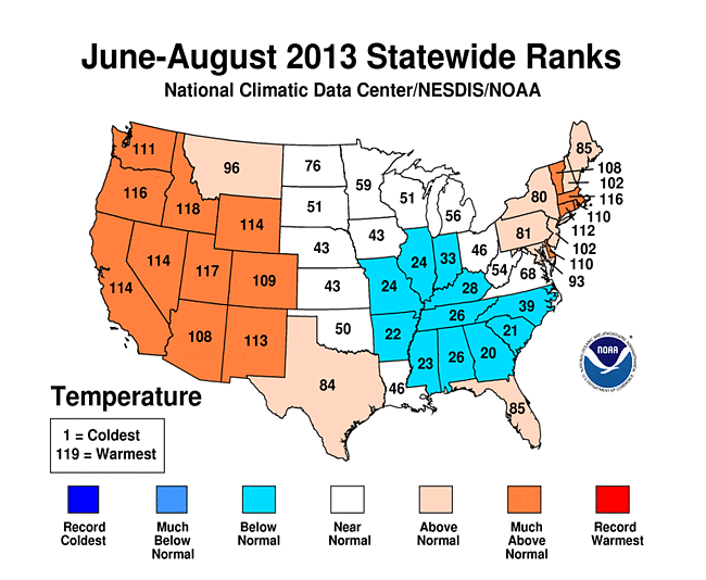

The CONUS average temperature during summer (June-August) was 72.6°F, 1.2°F above average, and tied with 1937 as the 15th warmest summer on record. This was on the heels of the summers of 2011 and 2012, both of which were among the three warmest summer seasons on record. Cooler-than-average temperatures were present during summer from the Midwest and into the Southeast. Above-average temperatures dominated West of the Rockies, with above-average temperatures also present in the Northeast. In the West, eight states had summer temperatures that ranked among the ten warmest on record. In the Northeast, Massachusetts had its ninth warmest summer on record. June was the 15th warmest such month on record for the CONUS with a temperature 2.0°F above average; the July temperature was 0.7°F above average, the 30th warmest July, and the CONUS had its 28th warmest August with a temperature 1.0°F above average. In Alaska, the statewide average temperature for the June-August period was 2.7°F above the 1971-2000 average and the second warmest summer in the 1918-2013 record. The state had its third warmest June, fifth warmest July, and 11st warmest August.
The CONUS precipitation total during summer was 9.53 inches, 1.28 inches above average, and the eighth wettest summer on record. This was the wettest summer since 2004. Most locations in the East had much-above-average precipitation during the June-August period. Twenty states, from Maine to Florida, had three-month precipitation totals that were among the top 10 wettest. New York, South Carolina, Georgia, and Florida each had their wettest summer on record. In fact, this was the second summer in a row that Florida broke its June-August precipitation record. Specific locations that had their wettest summer on record can be found here. Above-average precipitation was also observed in the Southwest and parts of the Plains. Arizona had its ninth wettest summer on record, partially due increased monsoonal precipitation during the season. Below-average precipitation was observed across the western Gulf States, parts of the Midwest and Northern Rockies and Plains. The June precipitation total ranked as the 13th wettest such month on record. Tropical Storm Andrea, the only tropical cyclone to make landfall in the U.S. during 2013, made landfall along Florida's Gulf Coast on June 6th, bringing heavy rain to parts of the Southeast. The July precipitation total ranked as the fifth wettest on record, while the August CONUS precipitation total was near average. In terms of the drought footprint, 44.3 percent of the Lower-48 was experiencing drought at the beginning of the summer, and 50.1 percent at the end of the summer. Drought conditions redeveloped across parts of the Upper Mississippi River Valley and Midwest. Drought improved in parts of the Southern Plains and Rockies and intensified in the West. The drought conditions in the West were also associated with several large wildfires, including the Rim Fire in California which burned over 255,000 acres, the third largest fire in California history; the Black Forest Fire, which destroyed over 500 homes near Colorado Springs, Colorado, the most destructive wildfire in Colorado history; and the erratic Yarnell Hill Fire, near Prescott, Arizona, that was responsible for 19 firefighter fatalities.
Fall


The September–November CONUS temperature of 54.1°F was 0.5°F above average and ranked near the long-term median value for the season. Most of the CONUS had near-average temperatures during the three-month season. Below-average temperatures were observed across parts of the Northeast, Mid-Atlantic, and Southeast. Above-average temperatures were observed in Florida and parts of the Rockies. September was the seventh warmest such month on record for the CONUS, with a monthly temperature 2.4°F above average, while the October temperature was below average, and the November temperature near average. Alaska had its tenth warmest autumn with a seasonal temperature 4.0°F above the 1971-2000 average. The seasonal warmth was mostly driven by a record warm October in the state, when the monthly temperature was 8.8°F above average and 1.1°F warmer than the previous record warm October. Locally, the Fairbanks average October temperature of 36.1°F was 11.9°F above normal.
The autumn CONUS precipitation total was 0.52 inch above average at 7.23 inches, and the 34th wettest autumn on record. Below-average precipitation was observed in the Southeast and parts of the Mid-Mississippi River Valley. California continued its trend of below average precipitation during 2013 with its tenth driest autumn season. Above-average precipitation was observed in parts of the Midwest, Gulf Coast, Rockies, Northern Plains, and Great Basin. Five states from Colorado to North Dakota had one of their ten wettest autumns on record. Much of the heavy precipitation fell during the month of September in Colorado. Between September 9th–16th, a cut-off low pressure system situated over the Great Basin pumped deep tropical moisture into the Colorado Front Range, resulting in record-breaking precipitation. Streams and rivers approached and exceeded record levels with widespread flooding reported. Colorado had its wettest September on record with 312 percent of average precipitation. Oregon and Washington also had a record wet September, which is part of the dry season there. However, below-average precipitation in those two states during October and November, led to a seasonal precipitation total that was near average. The CONUS drought footprint shrank drastically during the autumn. At the beginning of the season, 50.0 percent of the CONUS was experiencing drought, by the end of the season, the drought footprint shrank to 30.1 percent of the CONUS, the smallest extent in nearly two years. Drought improved across the High Plains, Southern Plains, and parts of the Rockies. Drought intensified in the Far West, with 98 percent of California in drought at the end of the season. Alaska had its third wettest autumn season with a precipitation total 42.7 percent above the 1971-2010 average. This marked the wettest autumn for the state since 1993 when the seasonal precipitation total was 52.0 percent above average.
Alaska Annual Summary


Alaska temperatures in 2013 were above the 1971-2000 average. The annual temperature for the state was 1.8°F above average and marked the 10th warmest year in the 95-year period of record for the state. This was the warmest year since 2005 for Alaska, when the temperature was 2.3°F above the 1971-2000 average. The warmest year on record for the state was 1926, when the temperature was 3.8°F above average. Alaska had its 27th warmest winter season, with a temperature 2.0°F above average. Alaska was cooler than average during the spring with a temperature 3.2°F below average, the 18th coolest such season on record. During the spring season, Alaska had its seventh coolest April on record. Temperatures quickly rose during the summer season, which was the second warmest summer on record for Alaska with a temperature 2.6°F above average. The warmest summer on record in Alaska occurred in 2004 when the seasonal temperature was 4.2°F above average. The summer of 2013 consisted of the third warmest June, the fifth warmest July, and 11st warmest August. Autumn ranked as the 10th warmest in Alaska, with a temperature 4.0°F above average. The state experienced its warmest October on record with a temperature 8.8°F above average. This bested the previous record warm October of 1925 by more than 1.0°F. The December temperature was 2.0°F above average — the 28th warmest such month on record.
The Alaska precipitation total during 2013 was 25.1 percent above the 1971-2000 average and ranked as the third wettest year in the 95-year period of record for the state. Only 1929 and 1963 were wetter. Alaska had its 17th wettest winter season, with a precipitation total 33.0 percent above average. Spring ranked as the 31st wettest season for the state with precipitation total 17.0 percent above average. Summer precipitation was slightly above average and ranked as the 48th wettest such season on record. Precipitation peaked during autumn, which was the third wettest such season on record. The seasonal precipitation total was 42.7 percent above average, and consisted of the 18th wettest September, 3rd wettest October, and 13th wettest November. December precipitation ranked as the fifth highest on record for the month at 51.0 percent above average.
Very Warm/Cold and Wet/Dry Percentages
One way to assess the magnitude of warm/cold and wet/dry episodes is to compute the percent area of the contiguous United States that was "very warm/very cold" and that which was "very wet/very dry". The figures above depict these values for each month in the past 30 years. These percentages are computed based on the climate division data set. Those climate divisions having a monthly average temperature/precipitation in the top ten percent (> 90th percentile) of their historical distribution are considered "very warm/very wet" and those in the bottom ten percent (< 10th percentile) are "very cold/very dry". The “very warm” categories translate to the “much above average” while the “very cold” categories translate to the “much below average” in terms of the NCDC ranking methods. This is similar for the “very wet” and “very dry” categories and the NCDC ranking methods of precipitation totals.
The table below shows the percent area of the nation "very warm" and "very cold" for each month of 2013 as well as the annual averaged values.
| Month | Percent area of CONUS "very warm" | Percent area of CONUS "very cold" |
|---|---|---|
| January | 1.89 | 6.66 |
| February | 0.44 | 0.00 |
| March | 12.98 | 13.37 |
| April | 3.50 | 24.30 |
| May | 2.53 | 3.31 |
| June | 21.92 | 0.00 |
| July | 24.09 | 8.39 |
| August | 11.64 | 3.29 |
| September | 32.44 | 0.04 |
| October | 0.26 | 13.93 |
| November | 1.01 | 3.61 |
| December | 1.39 | 16.14 |
| 2013 | 9.51 | 7.75 |
The table below shows the percent area of the nation "very wet" and "very dry" for each month of 2013 as well as the annual averaged values.
| Month | Percent area of CONUS "very wet" | Percent area of CONUS "very dry" |
|---|---|---|
| January | 9.95 | 9.96 |
| February | 11.69 | 14.81 |
| March | 0.74 | 18.18 |
| April | 12.00 | 7.64 |
| May | 15.60 | 8.66 |
| June | 15.29 | 16.09 |
| July | 25.85 | 8.34 |
| August | 10.59 | 10.54 |
| September | 28.62 | 2.22 |
| October | 14.79 | 7.76 |
| November | 3.56 | 3.51 |
| December | 13.18 | 13.12 |
| 2013 | 13.49 | 10.07 |
Climate Extremes Index
The annual USCEI was 18 percent, which is slightly below the long-term average extent of extremes. This was the first time since 2009 the annual USCEI value was below average. The principal contributor to this value was the large footprint of dry Palmer Drought Severity Index (PDSI) extremes, covering approximately twice the average area. The Southeast had approximately 41 percent of the region impacted by extremes in 2013. The above average extremes were primarily due to above average extent of cold maximum temperatures, wet PDSI, proportion of 1-day precipitation and days with precipitation.

Regional CEI values for spring 2013
In the spring (Mar-May), the USCEI indicated that approximately 28 percent of the CONUS was impacted by extremes. Regions which experienced an above average extent in extremes include the West, the Northern Rockies and Plains, and the Upper Midwest. In the West, warm temperatures, dry PDSI and extremes in the proportion of 1-day precipitation were the most significant factors to the elevated extent of extremes across the region. Cold temperatures, dry PDSI, and extremes in 1-day precipitation were above average across the Northern Plains and Rockies. Extremes across the Upper Midwest were seen primarily in the cold temperature and 1-day precipitation indicators.

Regional CEI values for summer 2013
During the summer (Jun-Aug), extremes in the USCEI covered about 24 percent of the CONUS. The Northwest, West, Southwest and Southeast Regions had extremes which were above average. An above average extent of warm temperatures and extremes in 1-day precipitation dominated the Northwest. Warm temperatures also impacted the West as well as an above average footprint of dry PDSI. A lack of substantial precipitation during 2013 led California to its driest year on record. In the Southwest, extremes in warm temperatures and dry PDSI prevailed. Conversely, the above average extent of extremes experienced across the Southeast were the result of cold maximum temperatures, warm minimum temperatures, wet PDSI and a large number of days experiencing precipitation.
In contrast to the two previous seasons, fall (Sep-Nov) had below average extremes across the CONUS with an extent of only 11 percent. Extremes in temperatures were nearly absent across the Lower 48 states. Below to near average extremes occurred in all regions except the Northern Rockies and Plains, where warm minimum temperatures, wet PDSI, 1-day precipitation extremes, and the number of days with precipitation were above average.
Monthly National Snow and Ice Report
The 2012/13 winter season (December 2012-February 2013) was warmer and wetter than average for the contiguous United States. December was warm (10th warmest) and wet (20th wettest) for the Lower-48, while January and February were both near average in terms of temperature and precipitation. Regionally, warmer-than-average temperatures during the three-month period were observed east of the Rockies, while the West had near- and below-average temperatures. In terms of precipitation, most locations east of the Rockies were also wetter than average, with the wettest locations being the Great Lakes and Southeast. The West Coast and Northern Rockies had below-average precipitation during the winter season. Several major winter storms did impact the central and eastern U.S. during the cold season of 2012/13 bringing with them significant snowfall, mostly during February and March, with two unusual late-season storms in April and May. However, snowfall and winter snowpack were below-average across the high elevations of California, the Great Basin, and the Southern Rockies. The low snowfall totals across California were a precursor to both the driest year on record in the state and the development of drought conditions during 2013.

According to data from the Rutgers Global Snow Lab, the winter snow cover extent was above average, while the spring snow cover extent was much above average. The satellite-derived snow cover extent for December 2012—February 2013 was approximately 1.3 million square miles, which was 127,000 square miles above the 1981-2010 average. This marked the 15th largest seasonal snow cover extent in the 1966-present period of record. Despite a below-average May snow cover extent for the Lower-48, the above-average snow cover in March and April was enough for the spring (March-May) snow cover extent to be 130,090 square miles above the 1981-2010 average of 355,500 square miles and the eighth largest spring snow cover extent on record. The above-average spring snowfall in many locations exceeded the amount of snow that was observed during the preceding winter season. A select list of those locations is available here.

Winter and spring mountain snowpack provide a crucial water source across much of the western United States. The total annual water budget for agriculture and human use in the mountainous West is highly dependant on the amount of snow melt that will occur in spring and is proportional to the amount of snow on the ground. The annual snowpack typically reaches its maximum value at the end of March. According to data from the USDA, on April 1st, above-normal snowpack was observed across the Cascades of Oregon and Washington; near-normal snowpack was present for much of the Northern Rockies of Idaho and Montana; below and much below normal snowpack was observed for central and eastern Oregon, the Sierra Nevada Mountains, much of the Great Basin and in the Central and Southern Rockies. Locations in California, Nevada, Arizona, and New Mexico had snowpack totals less than 25 percent of normal. In Alaska, much of the state had near-normal snowpack with the exception of northwestern and southwestern areas of the state. Snowpack totals greater than 130 percent of normal were reported along the Alaskan panhandle. By May 1st, the snowpack totals across the Sierra Nevada Mountains and the Southern Rockies were less than 25 percent of normal.
Monthly Tropical Cyclones Report


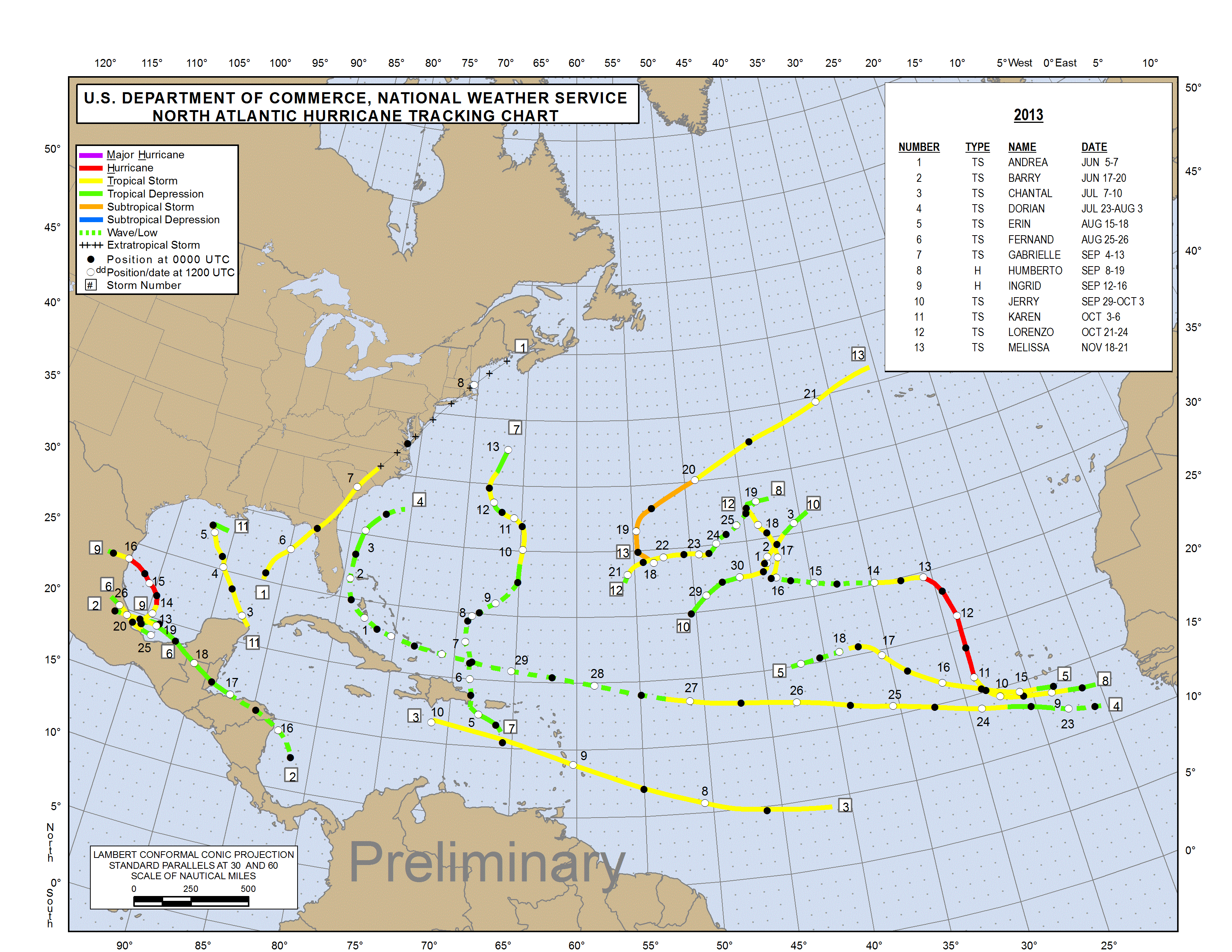
The 2013 North Atlantic hurricane season had 13 named storms, two hurricanes, and no major hurricanes. The number of tropical storms was slightly above the 1981-2010 average of 12.1, the number of hurricanes was below the average of 6.4, and the lack of major hurricanes was also below the average of 2.7. In terms of total named storms, this was the slowest season since 2009. The last time only two hurricanes were observed was in 1982 and the last season with no major hurricanes was 1994. The two hurricanes that formed during the season, Humberto and Ingrid, were both short lived. Humberto reached hurricane strength on September 11th, tying the latest date for the first hurricane of the season. The average date for the first hurricane is August 4th. No hurricanes made landfall in the U.S. during 2013. Tropical Storm Andrea made landfall along the Gulf Coast of Florida in June, and was the only tropical storm to directly impact the contiguous U.S. during the season. Hurricane Ingrid made landfall in Mexico in September, causing major flooding; more information is available below.
The Accumulated Cyclone Energy (ACE) index of tropical cyclone activity also indicated a below-average season in the North Atlantic. The ACE index is used to calculate the intensity of the hurricane season and is a function of the wind speed and duration of each tropical cyclone. The 2013 Atlantic hurricane season had an approximate ACE of 33 (x104 knots2) which was well below the 1981-2010 average value of 104 (x104 knots2). This is the lowest ACE for a hurricane season since 1983 and the 14th lowest in the 1851-present period of record. Despite the above-average number of named storms, the low number and short-lived nature of the hurricanes and the lack of major hurricanes depressed the ACE value for 2013 in the North Atlantic.
Individual tropical cyclone summaries are available through NOAA's National Hurricane Center.
Monthly Tornadoes Report

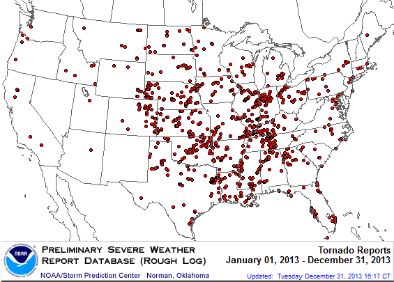
2013 Tornado Occurrences
Source: SPC
Similar to 2012, tornado activity across the U.S. during 2013 was below average. During 2013, there were 742 confirmed tornadoes during the January–September period, with 149 preliminary tornado reports still pending for October–December according to NOAA's Storm Prediction Center. This gives 2013 a preliminary tornado count of 891. Depending on the final confirmation rate, this could be the slowest tornado year since 1989 when 856 tornados were confirmed. The 1991-2010 annual tornado average is 1,253. Despite the below-average number of annual tornadoes, there were several large and destructive tornadoes and tornado outbreaks that led to significant damage and loss of life. There were 54 tornado-related fatalities and five severe weather and tornado outbreaks that resulted in at least one billion U.S. dollars in damage each.
The year started off with above-average tornado activity in January, when there were 75 confirmed tornadoes, well above the average of 35 for the month. February had a near-average tornado count, while the March tornado count was below average. Tornado activity remained below average during the climatologically most active time of year between April and July. However, several large tornado outbreaks did impact the U.S. during May, including the EF-5 tornado that hit Moore, Oklahoma. May was the deadliest tornado month of the year, with 41 reported tornado-related fatalities. Above-average tornado activity returned in November when a large late-season tornado outbreak hit the Midwest, with over 70 tornadoes confirmed. The monthly average number of November tornadoes is 58.
NOAA's National Climatic Data Center is the world's largest active archive of weather data. The preliminary temperature and precipitation rankings are available from the center by calling: 828-271-4800.
NOAA works closely with the academic and science communities on climate-related research projects to increase the understanding of El Niño and improve forecasting techniques. NOAA's Climate Prediction Center monitors, analyzes and predicts climate events ranging from weeks to seasons for the nation. NOAA also operates the network of data buoys and satellites that provide vital information about the ocean waters, and initiates research projects to improve future climate forecasts.