National Overview:
The  weather pattern for September consisted mostly of the Bermuda High pressure system (also known as the North Atlantic High) dominating the southern states with an active jet stream across the northern states. The Bermuda High brought persistent hot temperatures and dry weather to much of the region, deflecting most of the tropical systems out into the Atlantic or guiding them across the Caribbean and Gulf of Mexico along its southern periphery. However, moisture from the remnants of some of the tropical storms and hurricanes penetrated into the southern U.S., bringing locally heavy rains. These included the remnants of Tropical Storm Hermine, which moved across the southern Plains early in the month, and Hurricane Karl, which moistened Texas and areas further north in mid-September. Increased evaporation from unusually hot temperatures worsened drought conditions for those areas missed by the tropical moisture. By the end of the month, Louisiana had the second driest September on record and Alabama third driest, with dry conditions spreading into the Ohio Valley. Ten states, in the Southwest, Southeast, and Northeast, had the tenth warmest, or warmer, September on record.
Meanwhile, at least half a dozen strong low pressure systems and associated cold fronts moved across the northern states as they formed and were caught up in the jet stream flow. As a result of this persistent frontal activity, below-normal temperatures and heavy rains dominated the northern Plains and western Great Lakes. Moisture from the remnants of Hurricane Karl became entrained in the circulation, bringing flooding rains to parts of southwest Wisconsin, southern Minnesota, and southeast South Dakota and contributing to Minnesota's wettest September in the 1895-2010 record. A change in the upper-level circulation occurred during the last week of September. A dry high pressure ridge developed in the West as an upper-level trough built over the eastern U.S. and a strong upper low and associated cold front moved slowly into the Southeast. This combination brought cooler temperatures and locally heavy rains to parts of the Southeast and mid-Atlantic states. Moisture from the remains of Tropical Storm Nicole affected Florida in late September and became entrained in this upper-level system at the end of September and beginning of October, bringing torrential rains which ended the drought in parts of the East.
- Temperature Highlights - September
- September was the fourth consecutive month with above average U.S. temperatures. The average temperature was 1.7°F above the long-term average.
- Most states had above-average temperatures, and several others had monthly temperature ranking among their top 10 warmest: Rhode Island (third warmest), New Mexico (fourth), New Jersey (fourth), Colorado (fifth), Massachusetts (sixth), Florida (seventh), Connecticut (seventh), New Hampshire (seventh) Arizona (ninth), and Maine (ninth). No state had an average temperature ranking in the top ten coolest.
- Regionally, the Southwest climate region experienced its third warmest September on record. Only the East North Central climate region had below-normal temperatures.
- Year-to-Date (January–September)
- The nationally averaged temperature for 2010 year-to-date (January–September) was 56.9 °F, 1.0 °F above the long term mean.
- On a regional level, the Northeast climate region had its warmest 2010 year-to-date on record at 3.3 °F above the long term mean. Despite having a cool September, the East North Central climate region had its sixth warmest January-September period on record. No region had a January-September average temperature below normal.
- Several states had their warmest January-September on record: Maine, New Hampshire, Vermont, Massachusetts, Rhode Island, Connecticut, and New Jersey. In addition, New York, Pennsylvania, Delaware, Virginia, Michigan, Wisconsin, and Minnesota had average year-to-date temperatures in their top 10 warmest. Only Florida and Texas had below-normal temperatures for the period.
- Precipitation Highlights - September
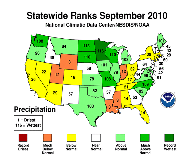
- Precipitation averaged for the entire U.S. was above normal. Several states had much below–normal precipitation and many others had much above–normal precipitation.
- Wyoming had its driest September on record with 0.90 inch of precipitation below the long term mean, while Louisiana had its second driest September and Mississippi its third driest.
- An active weather pattern across the northern tier of the country was associated with the East North Central climate region having its fifth wettest September on record. Numerous states in the central part of the country had much above normal precipitation during the month, including Minnesota which had its wettest September on record. Other states with September precipitation ranking in their top 10 wettest for the month include North Dakota (fourth wettest), Wisconsin (ninth), Washington (ninth), South Dakota (tenth), and Missouri (tenth).
- Year-to-Date (January–September)
- Precipitation averaged for the U.S. during the January–September period was 0.90 inch above the long term mean.
- The northern tier of the country has been consistently wet throughout 2010, and the East North Central region had its third wettest year-to-date period, while the West North Central region had its ninth wettest such period. The Southeast was the only climate region with below average precipitation for January–September.
- Numerous states had precipitation amounts ranking in their top ten wettest for the January–September period Wisconsin (second wettest), Iowa (second), North Dakota (third), South Dakota (fifth), and Minnesota (seventh). Conversely, Louisiana had its sixth driest such period.
- Other Items of Note
- An unusual heat wave affected Southern California the last week of September. On September 27th, the temperature in downtown Los Angeles reached 113 °F, setting a new all-time record high temperature for the city. Unfortunately, the official recording instrument then failed. However, the USCRN station at Fallbrook, CA, about 75 miles to the southeast, continued operating, reaching 113 °F twice for 5-minute periods during the afternoon at 1:25 p.m. and 2:50 p.m. local time. Wind speeds were light, indicating this was not likely due to Santa Ana winds, and humidity levels were less than 10 percent. Interestingly, the USCRN station in Death Valley reached only 112 °F. The USCRN station on the coast at Santa Barbara was a relatively pleasant 86 °F. The previous record for L.A. was 112 °F, set in June 1990.
- NCDC's Climate Extremes Index (CEI) for April-September ('The Warm Season') was about 35, or 15 points higher than the historical average, making it the fourth highest value since 1910. The CEI measures several types of climate extremes like record or near-record warmth, prolonged drought, flooding events, and frequency and intensity of storms like hurricanes and tornadoes. Factors contributing to the ranking: a very large area of the country experienced high temperatures over an unusually large number of days. For the year-to-date, extremes measured by the CEI were nearly 10 points higher than the historical average of 20.
- Based on NOAA's Residential Energy Demand Temperature Index (REDTI), the contiguous U.S. temperature-related energy demand for the warm season (April–September) 2010 was the ninth highest of the 116-year record. The unusual warmth in the highly populated mid-Atlantic and Southeast contributed to the high REDTI value.
- Drought coverage increased during September. The U.S. Drought Monitor reported 11.1 percent of the United States was affected by drought by September 28th. While improvements were seen in the southern Plains and the Upper Midwest, drought conditions deteriorated during the month in the Lower Mississippi River Valley, along the Gulf Coast and northward along the eastern Seaboard.
- Tornado activity across the U.S. during September was slightly below average. However, two rare tornadoes were confirmed in the New York City metropolitan area.
Alaska Temperature and Precipitation:
Beginning with January 2010 processing, the Alaska temperature and precipitation report is comprised of several datasets at NCDC, integrating GHCN and COOP datasets. Prior to 2010, the Alaskan temperature timeseries was processed with just GHCN data.
-
 Alaska
had its 18th warmest September since records began in 1918, with a temperature 1.8°F (1.0°C) above the 1971–2000 average.
Alaska
had its 18th warmest September since records began in 1918, with a temperature 1.8°F (1.0°C) above the 1971–2000 average.
-
 Alaska
had its 29th warmest July–September on record, with a temperature 0.4°F (0.2°C) above to the 1971–2000 average.
Alaska
had its 29th warmest July–September on record, with a temperature 0.4°F (0.2°C) above to the 1971–2000 average.
-
 Alaska
had its 27th warmest year–to–date on record, with a temperature 0.7°F (0.4°C) above the 1971–2000 average.
Alaska
had its 27th warmest year–to–date on record, with a temperature 0.7°F (0.4°C) above the 1971–2000 average.
-
 Alaska
had its 8th driest September since records began in 1918, with an anomaly that was 33.9 percent below the 1971–2000 average.
Alaska
had its 8th driest September since records began in 1918, with an anomaly that was 33.9 percent below the 1971–2000 average.
-
 Alaska
had its 38th driest July–September on record, with an anomaly that was 2.3 percent below the 1971–2000 average.
Alaska
had its 38th driest July–September on record, with an anomaly that was 2.3 percent below the 1971–2000 average.
-
 Alaska
had its 20th driest year–to–date on record, with an anomaly that was 8.0 percent below the 1971–2000 average.
Alaska
had its 20th driest year–to–date on record, with an anomaly that was 8.0 percent below the 1971–2000 average.
For additional details about recent temperatures and precipitation across the U.S., see the Regional Highlights section below. For information on local temperature and precipitation records during the month, please visit NCDC's Records page. For details and graphics on weather events across the U.S. and the globe please visit NCDC's Global Hazards page.
Regional Highlights:
These regional summaries were provided by the six Regional Climate Centers and reflect conditions in their respective regions. These six regions differ spatially from the nine climatic regions of the National Climatic Data Center.
- Northeast Region: (Information provided by the Northeast Regional Climate Center)
- The Northeast had its ninth consecutive month with above normal temperatures; in addition, it was the 7th consecutive month that all the states in the region averaged above normal. The regional average of 62.8 degrees F (17.1 degrees C) was 2.6 degrees F (1.4 degrees C) above normal and 2.8 degrees F (1.6 degrees C) warmer than September 2009. Temperature departures among the twelve states in the region ranged from 1.7 degrees F (0.9 degrees C) above normal in West Virginia to 3.9 degrees F (2.2 degrees C) above normal in Massachusetts and Rhode Island. Six states had averages that were within the top 10 warmest in 116 years: New Jersey and Rhode Island, 4th; Connecticut, Massachusetts and New Hampshire, 7th; and Maine, 9th. The Northeast ranked 21st warmest since 1895.
- Precipitation totals averaged below normal for the third month in a row. The Northeast average rainfall total was 3.41 inches (87 mm) and this was 86 percent of normal. Only two states, Maine (135 percent) and Maryland (125 percent) had totals that were above normal. Departures among the remaining states ranged from 53 percent of normal in Massachusetts to 79 percent of normal in New York.
- Three months of below normal rainfall has led to drought conditions, ranging from abnormally dry to extreme, in portions of the Northeast. According to the U.S. Drought Monitor issued September 28, 2010, the eastern panhandle of West Virginia and the western panhandle of Maryland were in extreme or severe drought, while most of New Jersey was experiencing severe or moderate drought conditions. Northern Connecticut, western Massachusetts and southern Vermont were also under moderate drought conditions. The Pennsylvania Department of Environmental Protection put 24 counties under a drought warning and the rest of the state under a drought watch as abnormally dry to severe conditions lowered ground and surface water levels. In mid–September, Maryland’s Department of the Environment issued a drought warning for the western panhandle and a drought watch for the eastern shore and the Washington, DC suburbs. Drought-related reports from around the region included reduced crop yields, smaller fruit size and early drop, local water restrictions and increased fire risk. While dry and sunny conditions are generally good for tourism, quite a few boat launch ramps were closed due to reduced water levels in lakes and reservoirs.
- A low-pressure system that formed over the Carolinas funneled tropical moisture to eastern U. S. on the 30th, dumping 3 to 6 inches (76 to 152 mm) of rain over central portions of the Northeast. A few locations in Maryland and southeastern Pennsylvania reported storm totals greater than 10 inches (254 mm). These totals relieved the dry conditions in the region, however, the heavy, steady rain also disrupted travel, sent rivers and streams over their banks and flooded low–lying neighborhoods. New daily rainfall records were set from West Virginia to New York, including Baltimore, MD (6.02 inches, 153 mm), Allentown, PA (5.73 inches, 146 mm), Washington, DC (4.66 inches, 118 mm), Binghamton, NY (4.24 inches, mm), and Williamsport, PA (3.91 inches, mm). Binghamton, NY’s total was an all-time daily record, topping the 4.05 inches (103 mm) that fell on June 27, 2006. Baltimore’s total was the 2nd all-time highest daily amount; the wettest day was August 24, 1933 with 7.62 inches (194 mm).
- For more information, please go to the Northeast Regional Climate Center Home Page.
- Midwest Region: (Information provided by the Midwest Regional Climate Center)
- Temperatures across Minnesota, Wisconsin, and the Michigan Upper Peninsula were 1degree F to 3 degrees F (0.9 to 2.7 degrees C) below normal during the month. In the central third of the region, September temperatures were near normal, although they were variable during the month. In the southeastern third of the region, temperatures were 1degree F to 3 degrees F (0.9 to 2.7 degrees C) above normal, with the greatest departures in the Ohio Valley. The month started out much cooler than normal, with temperatures running from 1degree F to 7 degrees F (0.9 to 6.3 degrees C) below normal across the region the first ten days of September. During the middle third of the month it remained cool in the northern Midwest, while temperatures ran from 1 degree F to 4 degrees F (0.9 to 3.6 degrees C) above normal in the south. The last ten days of September were warmer than normal everywhere but the far north, with departures running 6 degrees F (5.4 degrees C) above normal in the Ohio Valley. More than 270 record maximum and record high minimum temperatures were set in this period, including two readings of 100 degrees F (37.8 degrees C) in Kentucky.
- The active weather pattern across the central and northern Midwest brought abundant rainfall to those areas, while in the southwestern half of the Midwest lack of rain exacerbated drought conditions. Monthly rainfall across most of Minnesota, Wisconsin, Iowa, and Missouri was at least twice normal, with an area of 300 percent of normal across southern Minnesota. A preliminary analysis of Minnesota's rainfall by the Minnesota State Climate Office indicates that September 2010 was the wettest September in Minnesota's modern climate record. The state-average September rainfall total was 6.46 inches (164 mm), topping the previous high of 6.20 inches (158mm) from 1900. Rainfall was above normal over all but small portions of north-central and northeast Iowa. Iowa’s statewide average precipitation for the year to date already ranks as the ninth highest among 138 years of records. In Missouri, preliminary rainfall data indicate a statewide average of 8.46 inches (214.9 mm), nearly four inches (102 mm) above normal for the monthly. It was the fifth wettest September on record and the wettest September since 1993. All areas of the state experienced above normal rainfall with the exception of the Bootheel. Excluding the northwestern tip, the western one third of Missouri reported highest monthly totals between 8 to 12 inches (203 mm to 305 mm), whereas the Bootheel averaged less than three inches (76 mm). A few counties in southwestern Missouri reported more than 14 inches (356 mm) of rain for the month with locations in Christian and Greene counties reporting nearly 19 inches (483 mm). Alternatively, two Bootheel locations, Kennett and Caruthersville, reported less than one inch (25 mm) for the entire month. The Bootheel is classified as in Severe Drought on the U.S. Drought Monitor. Severe Drought was also depicted over much of southeastern Indiana.
- A major rain storm across southern Minnesota and central Wisconsin on September 22-24, on top of an already wet month, pushed many rivers well over flood stage in Minnesota and Wisconsin. Six to ten inches (152 mm to 254 mm) of rain fell in the southern tier of counties in Minnesota. The flooding closed roads and resulted in evacuations in some areas. At the end of the month moderate flooding was observed on the Minnesota, Wisconsin, and Mississippi Rivers, and in general streamflows were well above normal across the northern Midwest
- Two notable severe weather events hit during the third week of September. A tornado outbreak occurred in Ohio on September 16, when at least seven tornadoes were confirmed. A hailstone 5.5 inches (14 cm) in diameter was reported in western Missouri on September 18 and hail two inches (5.1 cm) or more in diameter caused extensive damage to vehicles during that event.
- For details on the weather and climate events of the Midwest, see the weekly summaries in the MRCC Midwest Climate Watch page.
- Southeast Region: (Information provided by the Southeast Regional Climate Center)
- Mean temperatures were above normal across the Southeast in September. The greatest departures occurred in a corridor from central Alabama to northern Virginia [4-6 degrees F (2.2-3.3 degrees C)] while Florida, Puerto Rico, and numerous coastal locations were 1-2 degrees F (0.5-1.1 degrees C) above normal for the month. At least 10 locations experienced their warmest September on record, including Raleigh-Durham, NC, Columbus, GA, Tampa, FL, and West Palm Beach, FL. Other locations experienced near-record warmth for the month, including Atlanta, GA, Tallahassee, FL, and Washington D.C. Across the region, 779 record daily maximum temperatures were tied or broken in September. The station on the University of South Carolina campus in Columbia recorded a high of 101 degrees F (38.3 degrees C) on the 20th of the month, making it the latest date in a calendar year that the temperature reached the century mark there in a record extending back to 1954. Raleigh-Durham Intl Airport in North Carolina recorded 16 days of 90 degree F (32.2 degrees C) temperatures or greater during the month, breaking the previous record of 15 days set back in September 1941. For the year, Raleigh-Durham has recorded 91 days of 90 degree temperatures or greater, which breaks the previous record of 83 days set back in 2007. The pattern of summer-like warmth across the region during most the month was the result of a persistent mid and upper level ridge that remained anchored over the eastern U.S. Moreover, for most of the month the region was dominated by a dry, continental air mass. Coupled with longer nights, this promoted strong radiational cooling and resulted in daily minimum temperatures that were near normal across most of the region (except for southern Florida). This was a significant change from the previous four months which saw an extraordinary number of record high minimum temperatures across the Southeast.
- It was truly “feast or famine” across the Southeast in September with respect to precipitation. For the first three weeks of the month, precipitation across a large portion of the region was less than 50 percent of normal and many locations were on track to set monthly record low precipitation totals. However, a combination of meteorological features across the southern U.S. and in the Caribbean conspired to produce a major precipitation event during the last week of September that affected South Florida, northeastern South Carolina, and the eastern half of North Carolina and Virginia. From the 26th to the 30th of the month, 262 record daily maximum precipitation totals were tied or broken in these regions. The precipitation was generated and sustained by a persistent feed of deep tropical moisture associated with a quasi-stationary upper-level low. Additionally, the remnants of Tropical Storm Nicole moved along a stalled frontal boundary later in the event. Over a six-day period, more than 8 inches (203.2 mm) of rain fell over eastern North Carolina and across the Virginia Tidewater region, with a swath of over 15 inches (381 mm) recorded in the North Carolina coastal plain. Wilmington, NC recorded 22.54 inches (572.5 mm) from the event, which set an all-time record for three, four, and five-day rainfall totals in a record extending back to 1871. The ensuing flooding resulted in a federal disaster declaration for New Hanover County. In addition, numerous thunderstorms occurred throughout northern and central Georgia beneath the core of the upper-level low. Monthly precipitation was 150 percent of normal in this region. In contrast, monthly precipitation totals remained less than 50 percent of normal across much of western North Carolina, central South Carolina, western Georgia, and central Florida. The driest parts of the Southeast (less than 25 percent of normal) were found across nearly all of Alabama, the Florida Panhandle, and parts of western and northeastern Florida. Remarkably, many COOP stations across Alabama failed to record any precipitation during the month. September precipitation was near normal across Puerto Rico.
- There were 114 reports of severe weather across the Southeast in September. A line of strong storms produced numerous high wind reports through central Virginia on the 22nd of the month. Strong storms associated with the aforementioned upper-level low produced golf ball-sized hail and high winds near Atlanta, GA on the 27th of the month. Only five tornadoes were reported across the Southeast in September. The strongest was an EF-1 that touched down in the western Piedmont of North Carolina (Burke County) on the 27th of the month and resulted in large pieces of flying debris, torn car ports, blown windows, and a collapsed garage wall. No casualties were reported. A series of weak tornadoes produced minor damage and felled trees in the northeast corner of North Carolina on the 29th of the month. The passage of Hurricane Earl off the U.S. East Coast resulted in a storm surge of 2-6 feet (0.6-1.8 m) and winds in excess of 80 mph (35.8 m/s) along the Outer Banks of North Carolina on the 2nd and 3rd of the month. Preliminary damage reports from Dare County totaled around $0.5 million.
- The warm temperatures and lack of rainfall across the Southeast in September resulted in an expansion of drought conditions across the region. By the third week of the month, over 85 percent of the region displayed D0 or greater conditions, up from 40 percent at the beginning of the month. Central portions of the Carolinas, which began the month drought-free, experienced moderate drought (D1) conditions by the end of September. The most notable change in the Drought Monitor occurred in eastern Alabama, where a small area observed extreme drought (D3) conditions. The warm, dry weather throughout much of the month continued to place stress on crops, particularly cotton, soybean, and peanuts. In Georgia, the peanut crop in particular was severely impacted as persistent warmth and dry soils forced an early season harvest with largely under-filled pods. In contrast, the pumpkin crop was plentiful across much of the region, particularly for farmers who planted early enough in the season to take advantage of the dry weather.
- For more information, please go to the Southeast Regional Climate Center Home Page.
- High Plains Region: (Information provided by the High Plains Regional Climate Center)
- September 2010 was cool and wet in the northern portion of the High Plains Region and the southern and western portions of the Region were warm and dry. Overall, the wet conditions slowed the harvest of row crops; however areas planting winter wheat welcomed the rain.
- Average temperatures for the month ranged from 2–6 degrees F (1.1–3.3 degrees C) below normal for most of the Dakotas, were near normal in Nebraska, and generally ranged from 4–6 degrees F (2.2–3.3 degrees C) above normal in much of Colorado, Kansas, and Wyoming. Central Colorado was particularly warm this month. High average temperatures, which were up to 9.0 degrees F (5.0 degrees C) above normal, allowed many locations to break into the top 10 warmest Septembers on record. Colorado Springs, Colorado recorded its warmest September on record with an average temperature of 67.0 degrees F (19.4 degrees C) which was 7.2 degrees F (4.0 degrees C) above normal (period of record 1894-2010). This broke the old record of 66.6 degrees F (19.2 degrees C) recorded in 1931.
- Above normal precipitation was mainly confined to the northern and eastern parts of the High Plains Region this month. Much of North Dakota, northern and eastern South Dakota, southeastern Nebraska, and eastern Kansas received at least 150 percent of normal precipitation. The southeastern corner of South Dakota has been extremely wet this year and this month’s wet spot was Brookings 2 NE, South Dakota. Brookings 2 NE received 8.43 inches (214 mm) of precipitation, or 340 percent of normal precipitation, which broke the old September record of 7.67 inches (195 mm) received in 1986 (period of record 1893-2010). The total precipitation received at Brookings 2 NE this year now totals 36.80 inches (935 mm) which sets a new record for the entire year! The previous record was in 2005 with 33.12 inches (841 mm) of precipitation.
- Severe weather was still a concern in some areas as hail damage to crops was reported in Nebraska, North Dakota, and Wyoming (source: National Agricultural Statistics Service). One storm in eastern Nebraska caused extensive damage on September 13th. The storm produced baseball sized hail and winds from 80–90 miles per hour (129–145 kilometers per hour). A University of Nebraska research facility near Mead, Nebraska sustained an estimated $1.5 million in damage as crops were flattened, buildings were damaged, and vehicles were totaled.
- Other areas of the Region received little to no precipitation this month. The majority of Wyoming, northern and central Colorado, southwestern Kansas, and the panhandle of Nebraska all received precipitation which was only 50 percent of normal or less. Some locations even received less than 5 percent of normal precipitation. This month’s dry spot was Boysen Dam, Wyoming which received no precipitation this month and set the record for driest September (period of record 1948–2010). The old record was 0.02 inches (0.5 mm) received in 1956.
- Above normal precipitation this month eliminated abnormally dry conditions (D0) in North Dakota, southeastern Nebraska, and northeastern Kansas, and changed the moderate drought conditions (D1) in South Dakota to D0. However, dry conditions allowed D0 to spread from western Colorado into eastern Colorado, eastern Wyoming, the panhandle of Nebraska, western Kansas, and southwestern South Dakota. In addition, an area of D1 had developed in central Colorado and extreme southern Wyoming where precipitation deficits were impacting soil moisture along with fall and winter crop decisions. According to the U.S. Seasonal Drought Outlook released September 16th, the drought conditions in western Wyoming and north central South Dakota were expected to improve through December 2010.
- For more information, please go to the High Plains Regional Climate Center Home Page.
- Southern Region: (Information provided by the Southern Regional Climate Center)
- Above normal temperatures continued on from August into September throughout most of the Southern Region. Only a small area of southern Texas experienced slightly below normal average temperatures for the month. In Louisiana, southern Arkansas and the majority of Mississippi, September average temperatures were generally 2–4 degrees F (1.11–2.22 degrees C) above expected values. Similar anomalies were also observed in central Tennessee, central Oklahoma and north central (and eastern) Texas. Temperatures deviated a little higher than normal in the Oklahoma panhandle and in north eastern Texas. Average temperatures there ranged from 4–8 degrees F (2.22–4.44 degrees C) above normal.
- As was the case in August, September precipitation totals varied significantly throughout the Southern Region. Only small pockets of the Southern Region experienced normal precipitation for the month; conditions were either very wet or very dry. In Mississippi, it was the third driest September on record (1895–2010). The state reported a monthly total of only 0.79 inches (20.07 mm) of precipitation. Precipitation totals throughout much of the southern half of the state remained below 25 percent of the monthly normal. Conditions were also very dry in Louisiana. The Bayou state reported a precipitation total of 1.36 inches (34.54 mm), which makes it the second driest September on record (1895–2010). Most stations in Louisiana reported less than half of the monthly normal. In Tennessee, conditions were dry through most of the state, except for in the north east, where some stations reported more than 150 percent of expected values. Elsewhere in the state, however; conditions were quite dry. In the western areas of Tennessee, most stations reported less than 25 percent of normal values, while in the central counties, precipitation totals ranged from 5 to 50 percent of normal. This was also the case in western Oklahoma, western Texas and the southern half of Arkansas. Areas that received an abundance of September precipitation included much of southern and central Texas and north western Arkansas. In the case of the former, a bulk of the precipitation was the direct result of tropical activity. Many stations through southern and central Texas reported precipitation totals for the month that ranged from 4 to over 15 inches (101.60 to over 381.00 mm). Tropical Storm Hermine, for example, which made landfall near Rio Grande, Texas on September 6, 2010, was responsible for dumping 15.62 inches (396.75 mm) of rainfall in Georgetown, Texas (just north of Austin). Hurricane Karl, which did not pass through Texas, did push some of its rain bands through the state of Texas. Areas in southern Texas received in excess of 10 inches (254.00 mm) from the storm, which led to widespread flooding (See Drought and Severe Weather). For Texas, it was the 18th wettest September on record (1895-2010), with a state-wide precipitation total of 4.43 inches (112.52 mm). In the case of north western Arkansas, heavy precipitation led to monthly totals that ranged from 150 to 300 percent of normal. Station examples of high monthly precipitation totals in north western Arkansas include: Lead Hill, Arkansas, which reported 13.79 inches (350.27 mm), Compton, Arkansas, which reported 11.30 inches (287.02 mm), and Omaha, Arkansas, which reported 12.98 inches (329.69 mm) for the month. In fact, almost all stations in the Northwest Climate Division reported over 5 inches (127 mm) of precipitation for the month.
- Drought conditions in the Southern Region have changed dramatically over the past month. Dry conditions have led to the introduction of moderate drought throughout much of the state of Mississippi. This change is due in part to the fact that the state of Mississippi experienced its third driest September on record (1895–2010). Drought conditions have also deteriorated in south western Louisiana, which last month was drought free, but is now classified as moderate drought. Similarly, dry conditions in Arkansas have led to a one category deterioration. Counties along the eastern and southern border of the state are now classified as being in severe drought. Wet conditions in southern Texas, north western Arkansas and south central Oklahoma have led to a one category improvement from moderate drought to being drought free. In total, as of September 28, 2010, 20 percent of the Southern Region is experiencing moderate drought or worse, with 6.8 experiencing severe drought or worse. Only 0.8 percent of the Southern Region is experiencing extreme drought. The latter is confined to several Parishes in northern Louisiana.
- On September 7, 2010, a tornado touched down in Lavarca, County Texas. Power lines were reported to have been damaged
- On September 8, 2010, a cluster of twisters were reported in north central Texas and in south central Oklahoma. One tornado–related injury was reported in Bryan County, Oklahoma. The twister there also damaged two homes and overturned two cars. In Lamar, County Texas, homes suffered roof damage due the brief touchdown of a tornado there. Similar damage was also reported that day in Carter, County Texas.
- The major weather story in Texas during September 2010 was heavy precipitation that fell in a large area of central and southern Texas, which caused widespread flooding. Tropical Storm Hermine was the main culprit for flooding during the first half of the month, while Hurricane Karl provided moisture for flooding rains during the second half of the month. Tropical Storm Hermine came onshore along the northeastern Gulf Coast of Mexico late on the 6th and maintained tropical storm strength as it passed over San Antonio on the 7th. Overall, 40 counties were declared federal disaster areas in the storm’s aftermath. The total damage from the storm in Texas was estimated to be $150-$200 million. Seven deaths have been directly attributed to Hermine, all related to flooding, after the storm dumped more than more than a foot across a large swath of the state, including 15.62 inches (396.75 mm) in Georgetown. An elderly Arlington woman also died after equipment left at her home to deal with the flooding caught fire. Damage due to high winds with Tropical Storm Hermine coming on shore was minor and confined to the lower Rio Grande Valley. About 30,000 customers lost power due to downed lines in Cameron and Willacy counties. However, the storm did spawn 6 tornadoes in North Texas on the 8th, including an EF-2 tornado in the industrial district of West Dallas that caused significant damage to a warehouse. Three apartment buildings in the community of Seagoville suffered heavy damage and displaced at least 12 families. The outer bands of Hurricane Karl brought rainfall in excessive of 10 inches (254.00 mm) to areas of South Texas, which caused widespread flooding. A Corpus Christi man was killed when his car was swept away by floodwaters in Oso Creek, which reached a record 30.62 feet (9.33 m) . The flooding damaged 180 homes in a Corpus Christi subdivision. Farther south, more than 10 inches (254.00 mm) of rain fell in the Lower Rio Grande Valley in association with Karl and another disturbance passing through the region. More than 60 homes suffered significant flood damage in a neighborhood on the west side of Brownsville. Additionally, the International Boundary and Water Commission decided to release water into a spillway for the second time in 2010 (Impact Information for this bullet was provided by The Texas Office of State Climatology).
- For more information, please go to the Southern Regional Climate Center Home Page.
- Western Region: (Information provided by the Western Regional Climate Center)
- Temperatures were mostly above normal throughout the West except for portions of coastal California, the Pacific Northwest and northern and eastern Montana. At Los Angeles Airport it was the coolest September since 1986. At San Diego-Lindbergh Field only 12 days out of the past 152 (from May-Sep) were above the 30-year normal and half of those occurred on the final 6 days of September. It was the 4th coolest May-Sep at San Diego in the past 80 years. The cool summer ended with the warmest reading ever at the Los Angeles Civic Center, noted below.
- Rainfall was well below normal throughout the region except for the Pacific Northwest, Montana and isolated pockets of the interior Southwest. This was the third wettest September at Seattle dating back to 1948 and second wettest in Olympia. The month was very dry across the central Intermountain West. It was the first September in Lander, WY, to receive no precipitation dating back to 1948 and Cheyenne was tied for the driest September (.01”) dating back to 1915. As a study in contrasts, this was the driest September at Pueblo, CO, in 54 years yet only 125 miles southeast in Clayton, NM, it was third wettest September dating back 50 years.
- Significant Events:September 6-13: Four Mile Canyon Fire, Boulder, CO — Fire 5 miles west of Boulder burned nearly 6,200 acres and destroyed at least 48 homes. Strong winds and dry conditions led to the evacuation of about 3,500 people at one point before the fire was under control. September 19-26: Machine Gun Fire, Herriman, UT — Machine gun fire at a nearby Army National Guard training camp sparked a wildfire on the 19th that quickly grew to 3,500 acres the next day thanks to hot, dry conditions and 50 mph winds. Roughly 1,600 homes were evacuated and 4 homes were burned. September 27: Record heat in California — The temperature reached 113 degrees F (45 degrees C) in downtown Los Angeles breaking an all-time record for that site dating back over 100 years. This heat affected all of southern California and broke many records. Even coastal locations reported temperatures of over 100 degrees F (38 degrees C). Nearly 30,000 customers were without power on Monday the 27th as the Los Angeles Department of Water and Power recorded it highest ever demand for electricity. September (all month): Twitchell Canyon Fire, Utah — This lightning caused fire began July 20th and has grown to over 42,000 acres and was only 28 percent contained by the end of this month.
See NCDC's Monthly Records web-page for weather and climate records for the month of May. For additional national, regional, and statewide data and graphics from 1895-present, for any period, please visit the Climate at a Glance page.
PLEASE NOTE: All of the temperature and precipitation ranks and values are based on preliminary data. The ranks will change when the final data are processed, but will not be replaced on these pages. Graphics based on final data are provided on the Temperature and Precipitation Maps page and the Climate at a Glance page as they become available.