National Overview:
- Temperature Highlights - March
- For the month of March
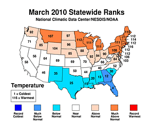
 the temperature, averaged across the contiguous U.S., was above normal. Several storms developed along the Atlantic Coast, bringing below-normal temperatures to the South and Southeast, while bringing warm and wet weather to the Northeast and East North Central regions.
- On a
 statewide level,
  Rhode Island had its warmest March on record. It was
  Maine's second warmest March,
  New Hampshire's third warmest, and the fifth warmest for
  Massachusetts,
  Connecticut,
  New Jersey,
  Vermont, and
  Minnesota. Five other states (for a total of thirteen) also had a March average temperature among their ten warmest.
 - Cooler-than-normal temperatures prevailed across the Gulf Coast states, plus New Mexico, Georgia and South Carolina. This cool pattern was most pronounced in
 Florida which experienced its fourth coolest March on record.
 - For the
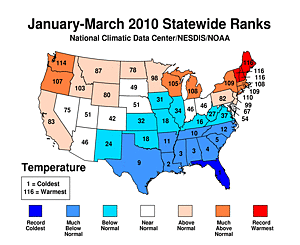 year-to-date (January-March) period, climatic extremes were seen the
  Northeast where
  Maine,
  Vermont and
  New Hampshire each experienced their warmest such period. Other states that were abnormally warm were Washington (3rd warmest), Connecticut (7th warmest), Rhode Island and New York (8th warmest), Massachusetts and Michigan (9th warmest), and Oregon (10th warmest).
 - The unrelenting cool pattern during the winter season spilled into the three-month period as several states were below normal. It was Florida's coldest ever, Louisiana's second coldest, and the third coldest for Mississippi and Alabama. Georgia, South Carolina, and Texas also experienced a January-March period that ranked among their five coolest.
- The past six months (October-March) were abnormally warm in the Northeast. Maine had its warmest such period, New Hampshire had its third, and Vermont its eighth.
- Precipitation Highlights - March
-
March precipitation, averaged across the contiguous United States, was below the long-term mean. The national average of 2.16 inches ranked as the 35th driest. The Northeast was above-normal, while the Central and East North Central climate regions were below-normal. All other regions were near normal.
-
 Massachusetts,
  New Jersey and
  Rhode Island had a record wet March.
  Connecticut and
  New Hampshire experienced their second and fifth wettest March on record, respectively. March was dry for Michigan, Montana, and Wisconsin where precipitation values were fourth, sixth and ninth driest, respectively.
 - Precipitation extremes were widespread throughout the country for the
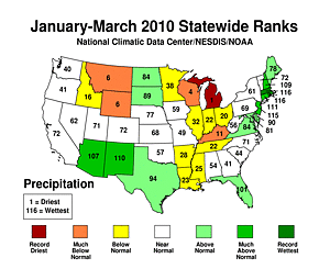 year-to-date period.
  Michigan had its driest January-March period. Dry conditions also prevailed in
  Wisconsin (4th driest),
  Montana and
  Wyoming (6th driest).
 - A ubiquitous storm track during
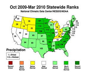 October-March delivered much-above normal precipitation averages to much of the eastern United States.
  Massachusetts,
  Rhode Island and
  New Jersey had their wettest such period. A total of 20 states had precipitation rankings in the top ten wettest.
 - Other Items of Note
- The 2009-2010 Cold Season (Oct-Mar) Climate Extremes Index (CEI) was 26 percent, which is 6 percent above average. Contributing factors to this elevated CEI value were: the extent of cool maximum temperature extremes, a footprint of extreme wetness more than three times the average, and the number of extreme precipitation days around the country.
- According to the Storm Prediction Center, the preliminary tornado count for the month of March was 36. This tied as the 14th quietest March since reliable records began in 1950 and it was the third fewest since 1980. Final counts are usually less than the preliminary counts, so the final rank might change.
- According to the Canadian Ice Service, mid-March ice coverage over the Great Lakes was at a record low - only 3.5 percent of the lakes' surface. The normal ice extent for the period is roughly 31 percent of the lakes' surface. Records go back to 1973.
- In the Northeast, flooding episodes reflected the record and near-record precipitation seen throughout the region. In the Midwest, several rivers flooded in part because of rapid snow melt in the region.
- Based on NOAA's Residential Energy Demand Temperature Index (REDTI), the contiguous U.S. temperature-related energy demand was 8.2 percent below average for March and 0.6 percent above average for the Cold Season (October-March).
- Drought coverage remained small throughout the month. On March 30, the U.S. Drought Monitor reported that 9.0 percent of the United States was affected by drought.
 the temperature
 statewide level
 Rhode Island
 Maine's
 New Hampshire's
 Massachusetts
 Connecticut
 New Jersey
 Vermont
 Minnesota
 Florida
  year-to-date
 Northeast
  Maine
Maine Vermont
 New Hampshire
  Massachusetts
 New Jersey
 Rhode Island
 Connecticut
 New Hampshire
 year-to-date
 Michigan
 Wisconsin
 Montana
 Wyoming
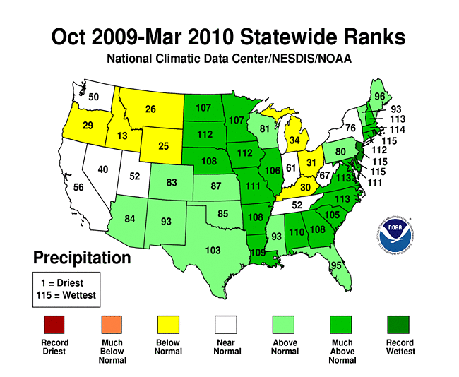 October-March
 Massachusetts
 Rhode Island
 New Jersey
Beginning with January 2010 processing, the Alaska temperature and precipitation report is comprised of several datasets at NCDC, integrating GHCN and COOP datasets. Prior to 2010, the Alaskan temperature timeseries was processed with just GHCN data.
-
 Alaska
had its 40th coolest March since records began in 1918, with a
temperature 1.6°F (0.9°C) below the 1971–2000
average.
Alaska
had its 40th coolest March since records began in 1918, with a
temperature 1.6°F (0.9°C) below the 1971–2000
average.
-
 Alaska
had its 34th warmest year–to–date on record, with a
temperature 1.4°F (0.8°C) above the 1971–2000
average.
Alaska
had its 34th warmest year–to–date on record, with a
temperature 1.4°F (0.8°C) above the 1971–2000
average.
-
 Alaska
had its 47th wettest March since records began in 1918, with
an anomaly that was 6 percent above the 1971–2000
average.
Alaska
had its 47th wettest March since records began in 1918, with
an anomaly that was 6 percent above the 1971–2000
average.
-
 Alaska
had its 13th driest year–to–date on record, with
an anomaly that was 22 percent below the 1971–2000
average.
Alaska
had its 13th driest year–to–date on record, with
an anomaly that was 22 percent below the 1971–2000
average.
For additional details about recent temperatures and precipitation across the U.S., see the Regional Highlights section below. For information on local temperature and precipitation records during the month, please visit NCDC's Records page. For details and graphics on weather events across the U.S. and the globe please visit NCDC's Global Hazards page.
Regional Highlights:
These regional summaries were provided by the six Regional Climate Centers and reflect conditions in their respective regions. These six regions differ spatially from the nine climatic regions of the National Climatic Data Center.
- Northeast Region: (Information provided by the Northeast Regional Climate Center)
- March temperatures in the Northeast averaged 40.2 degrees F (4.6 degrees C), which was 5.5 degrees F (3.1 degrees C) above normal. Departures ranged from 1.4 degrees F (0.8 degrees C) above normal in West Virginia to 7.6 degrees F (4.2 degrees C) above normal in Maine. This was the third consecutive month that Maine's departure was +7 degrees F (3.9 degrees C) or greater. March 2010 was the warmest March in 116 years in Rhode Island and the 2nd warmest in Maine. Other state rankings are below; overall, the Northeast saw its 6th warmest March since 1895. High's reached the upper 60's (teens C) and low 70's (twenties C) during the third week of the month, establishing new maximum temperature records from New Jersey to Maine.
- With such warm temperatures, precipitation was mostly in the form of rain. The region averaged 4.62 inches (117.3 mm) of precipitation, which was 131 percent of normal. There was quite a gradient in precipitation totals from west to east; areas downwind of the Great Lakes in western New York and northwestern Pennsylvania received only 25 to 50 percent of the normal, while sections of the New England coast saw over 300 percent of normal rainfall. Three eastern states, Massachusetts, New Jersey and Rhode Island, had their wettest March since records began in 1895. In addition, Connecticut had its 2nd wettest March; New Hampshire, its 5th wettest; and this was the 17th wettest March in the Northeast. Precipitation departures for the month ranged from 84 percent of normal in West Virginia to 331 percent of normal in Rhode Island. Many precipitation records were set, including new monthly totals at Boston, MA, Portland, ME, Bridgeport, CT, Central Park, NY and Providence, RI. The totals at each of these locations exceeded 10 inches (254 mm) and the monthly total at Providence (16.34 inches, 41.5 mm) is also a new all-time monthly record. March was notable for the lack of snow in normally snowy locations. Syracuse and Rochester, NY ended up with zero snow in March, the first time that has occurred at either location.
- During February, three major winter storms brought record and budget breaking snow totals to the mid-Atlantic region. The weather pattern shifted, but was just as active in March, with three major rain events that severely impacted parts of the Northeast, especially Massachusetts and Rhode Island. The first storm hit the region from the 13th to the 15th, drenching the area from New Jersey to southern Maine. The highest rainfall amounts were in eastern Massachusetts and southeastern New Hampshire where as much as 9 inches (229 mm) of rain fell. In many cases, the rain fell on soil already waterlogged from snowmelt, leaving no room for absorption. Flood warnings were issued for rivers in Connecticut, Maine, Massachusetts, New Hampshire, New Jersey, and Rhode Island. The Pawtuxet River in Rhode Island flooded to a new record height of 14.98 ft (4.6 m); the Charles and Concord Rivers in Massachusetts also reached new record heights. High winds, with gusts up to 75 mph, (34 m/s) combined with the soggy conditions, felled trees and power lines, leaving about 900,000 customers without power. At least 8 deaths were reported, most caused by falling trees. High amounts of runoff forced a few sewage treatment plants, including Boston, MA and Bristol, RI, to release raw sewage into local bays. This resulted in the closing Bristol Harbor and upper Narragansett Bay to shellfish harvesting for at least a week.
- Just as floodwaters were receding, the next storm on the 22nd and 23rd added 2 to 5 inches (51 to 127 mm) of rain to the monthly totals in a large portion of the Northeast. The highest amounts fell in southeastern Rhode Island, flooding homes, roads and businesses as the Pawtuxet River crested to 12 ft (3.6 m) (3 ft, 0.9 m above flood stage).
- The last rain event of the month soaked eastern portions of the region once again, with the highest totals in eastern Connecticut, southern Rhode Island and southern Massachusetts. Totals of 5 to 9 inches (127 to 229 mm) caused unprecedented flooding in this area, with the Pawtuxet River cresting at a new high of 20.79 feet (6.3 m). The Taunton and Sudbury Rivers in Massachusetts and the Yantic River in Connecticut also reached new record heights. Floodwaters closed a section of I-95 in Rhode Island for two days and Amtrak suspended service from New Haven, CT to Boston until the water receded from its tracks. At least two wastewater treatment plants in Rhode Island were out of commission due to high water flooding their pumps. An electric power substation in Cranston, RI was under water, leaving up to 14,000 customers without power. Throughout the affected area, bridges and roads were damaged, while businesses and homes filled with debris and toxic floodwaters. The costs, while not yet assessed, will be high.
- For more information, please go to the Northeast Regional Climate Center Home Page.
- Midwest Region: (Information provided by the Midwest Regional Climate Center)
- Winter made a quick transition to spring across the Midwest in March. Temperatures gradually warmed as the month progressed, with a rapid warm up at the end of the month that pushed temperatures into the 70s (21 degrees C to 26 degrees C) across the region. Temperature departures were near normal to 1degrees F (0.5 degrees C) below normal south of the Ohio River and across much of Missouri and southwestern Iowa. Over the rest of the region, the gradient in temperature departures northward was remarkable. Temperatures from Iowa eastward through Ohio were generally 1 degrees F to 4 degrees F (0.5 degrees C to 2.2 degrees C) above normal. From there, temperature departures ranged from 5 degrees F (2.8 degrees C) in central Minnesota and Wisconsin to 10 degrees F (5.6 degrees C) above normal from northern Minnesota to the western Upper Peninsula of Michigan.
- March was also very dry across the northern Midwest, with precipitation less than 25 percent of normal across most of Wisconsin and Michigan, and less than 10 percent of normal across the Michigan Upper Peninsula. The U.S. Drought Monitor continues to depict Moderate to Severe Drought in northern Wisconsin and the western Michigan Upper Peninsula. Precipitation was less than 50 percent of normal over central Kentucky, and Abnormal Dryness was depicted there. The central portion of Kentucky, including Louisville, Lexington, and Bowling Green, has experienced five consecutive months of below normal rainfall. For this area, precipitation is around 5 to 10 inches below normal for the November to March time period which ranks among the top ten driest such periods. In the remainder of the region, precipitation was at least 75 percent of normal. Far western Missouri received normal precipitation and a band from northwest Missouri across north-central Illinois and into central Indiana and Ohio received from 100 to 125 percent of normal. The precipitation occurred mostly during the second week of March. Another round of significant precipitation occurred during the last ten days of the month. The episodic precipitation was often associated with slow moving low pressure systems, and resulted in heavy rain which caused flash flooding.
- Southwestern and western Missouri was the only part of the Midwest to receive above normal snow fall during March and all of this snow came in one storm March 19-20. The dry and warmer than normal weather in the northern Midwest brought an early end to the snow season there. From Grand Rapids to Rochester, Minnesota, scores of observers reported a snowless March, the first time in history for many. In the Twin Cities it was the first snowless March since 1878. In Iowa, the statewide average snowfall was 2.0 inches (5 cm) for the month, or 2.8 inches (7 cm) less than normal. This ranks as the 23rd lowest March total among 123 years of record. However, the meager March snowfall was enough to push the statewide average seasonal snowfall total to 47.7 inches (121 cm) or seventh highest of record (greatest total since 1978-1979 winter).
- Runoff from the melting of a deep snow cover in the northern Midwest and additional rain resulted in flooding along many rivers and streams in Minnesota, Iowa, Illinois, and Missouri. Major rivers in flood this month included the Red River in Minnesota, the Des Moines River in Iowa, the Mississippi River from the headwaters to south of St. Louis, and the Illinois River. Lack of precipitation in the northern Midwest kept flooding from becoming worse, and by the end of the month river and stream levels, while still above flood stage in many areas, were falling.
- For details on the weather and climate events of the Midwest, see the weekly summaries in the MRCC Midwest Climate Watch page.
- Southeast Region: (Information provided by the Southeast Regional Climate Center)
- Monthly average temperatures for March 2010 were below normal across the southern three quarters of the region. Mean temperatures were more than 5 degrees F (2.8 degrees C) below normal across southern Alabama and Georgia as well as Florida. This marked the third consecutive month in which temperatures were well below normal temperatures across the region. The coldest temperatures occurred during the first week of the month as a strong cyclone moved northeastward along the coast advecting very cold air southward in its wake. Under clear skies and calm winds, minimum temperatures dropped to 20 and 26 degrees F (-6.7 and -3.3 degrees C) in Elberton, Georgia and Tallahassee, Florida, respectively, on the 6th of the month. There were 126 record daily minimum temperatures tied or broken during the month, and the vast majority of these were registered in Florida. Temperatures were more than 2 degrees above normal across portions of central Virginia and northeastern North Carolina. It was the warmest March in a 47-year record at Dulles Airport in northern Virginia where the temperature dropped to freezing or below only six times during the month. The warmest temperatures of the month occurred on the 20 and 21st across much of the region as an approaching cyclone advected warm air into the region. Amelia, Virginia and Lewiston, North Carolina reached 82 and 80 degrees F (27.8 and 26.7 C), respectively, during this period. Monthly mean temperatures were above normal across Puerto Rico for the second consecutive month.
- Precipitation totals for March 2010 were below normal across most of the region. Precipitation totals were less than 75 percent of normal across much of South Carolina, portions of North Carolina, and much of southern Georgia, Alabama as well as northern Florida and extreme southern Florida. Key West, Florida and Albany, Georgia recorded only 0.34 inches and 1.67 inches (9 and 42 mm) of precipitation, which was only 18 percent and 32.6 percent of normal for the month. Precipitation totals were more than 200 percent of normal across a small portion of northern and central Virginia and along an east to west oriented band stretching across South Florida. Okeechobee, Florida received 12.53 inches (318 mm) of precipitation for the month, which was 9.60 inches (244 mm) above normal. Orlando, Florida recorded nearly 9 inches of precipitation, making it the 4th wettest March in a record extending back to 1948. Farther north, Keysville, Virginia received 8.90 inches (226 mm) of precipitation for the month, which was 5.62 inches (143 mm) above normal. Over half of this precipitation fell on the 29th of the month as a series of strong thunderstorms trained northeastward across west central North Carolina and central Virginia. Monthly precipitation totals were below normal across much of the interior of Puerto Rico, and above normal along portions of the northern coast. San Juan Puerto Rico received over two inches of precipitation on the 11th of the month.
- There were 168 severe thunderstorm reports across the region during the month, including 27 tornadoes. On the 25th of the month, four tornadoes were reported in Alabama, one of which damaged 5 structures and destroyed one in Chilton. On the 27th of the month, an approaching strong cyclone and frontal system contributed to the development of a swarm of supercell thunderstorms across the central Carolinas and southern Virginia. These storms produced at least 12 tornadoes, a few which were strong (EF-2). One of these tornadoes caused three injuries and ripped off the roofs of several buildings near High Point, North Carolina.
- In polar contrast to February, there was relatively little snowfall across the region. After a record snowy winter season, only trace amounts of snow were observed in the Washington, DC area during the month of March. On the 2nd of the month, a strong cyclone moved northeastward along the Atlantic Coast dropping snowfall over mountainous portions of southwestern Virginia, western North Carolina, and portions of northeastern Georgia. Asheville, North Carolina and Mountain City, Georgia reported 8.8 inches and 9.2 inches (224 and 155 mm) of snow, respectively, in this event.
- For more information, please go to the Southeast Regional Climate Center Home Page.
- High Plains Region: (Information provided by the High Plains Regional Climate Center)
- In stark contrast to the colder than normal temperatures of February, March 2010 was warmer than normal across the majority of the High Plains Region. Many locations of the Region were near normal. However, temperature departures ranged from 2 degrees F (1.1 degrees C) to 9 degrees F (5.0 degrees C) above normal from central Nebraska to Wyoming to the Canadian border. Isolated areas of the Region had temperature departures that were greater than 2 degrees F (1.1 degrees C) below normal. These occurred in central Colorado, southern and eastern Kansas, and pockets of Nebraska and North Dakota. Many locations across eastern portions of North Dakota were ranked in the top 10 warmest. This month's warm location was Fargo, North Dakota which recorded its 4th warmest March on record (period of record 1881-2010). The average temperature was 35.4 degrees F (1.9 degrees C) which was 8.2 degrees F (4.6 degrees C) above normal. The warmest March on record occurred in 1910 when the average temperature was 40.9 degrees F (4.9 degrees C).
- March was an active month for many areas of the Region. Areas of the Region which received at least 150 percent of normal precipitation included central North Dakota, south central South Dakota, southwestern Nebraska, isolated pockets of Kansas, southeastern Wyoming, and western, central, and southeastern Colorado. Major flooding was reported in the Red River Valley in North Dakota and heavy precipitation broke records in southeast Colorado. Unfortunately, precipitation was lacking in areas which were already experiencing abnormally dry or drought conditions. This caused severe drought to develop in western Wyoming and moderate drought to develop in north central Colorado. This month?s wet location was again south central Colorado where precipitation totals were well over 300 percent of normal. The Trinidad Perry Stokes Airport, Colorado received 3.65 inches (92.71 mm) of precipitation which was 388 percent of normal precipitation (period of record 1948-2010). This crushed the old record of 2.58 inches (65.53 mm) received in March 2000. Interestingly, this was the second record breaking month in a row as the Trinidad Perry Stokes Airport, Colorado also set its wettest February on record in 2010. Of the total monthly precipitation at the Trinidad Perry Stokes Airport, 2.22 inches (56.39 mm) fell in one day, March 8th. This amount not only set the new record for the day, but also for the highest one day precipitation total for the month of March and the 4th highest one day precipitation total for entire period of record. The previous record for one day precipitation for March occurred March 18, 1984 when 0.95 inches (24.13 mm) of precipitation fell.
- There were big changes to the U.S. Drought Monitor for the High Plains Region this month. Abnormally dry conditions (D0) spread further east in Wyoming, while moderate drought conditions (D1) developed in north central Colorado. In addition, severe drought conditions (D2) developed in western Wyoming due to continued below average snow water equivalence measurements and below normal precipitation. According to the U.S. Seasonal Drought Outlook released March 18th, the abnormally dry and drought conditions in northwestern Colorado and western Wyoming are expected to persist through June 2010.
- For more information, please go to the High Plains Regional Climate Center Home Page.
- Southern Region: (Information provided by the Southern Regional Climate Center)
- As was observed last month, and over much of the winter, March mean monthly temperature averages in the Southern Region remained below normal. In southern Texas, southern Louisiana and southern Mississippi, temperature values varied from 4 to 6 degrees F (2.22 to 3.33 degrees C) below the monthly normal. The state-wide temperature average for Louisiana was 55.30 degrees F (12.94 degrees C), which was the 15th coldest March on record (1895-2010). For Mississippi, it was the 20th coldest March (1895-2010), with a state-wide average temperature of 52.10 degrees F (11.17 degrees C). Texas observed its 25th coldest March on record (1895-2010), with a state-wide average temperature of 54.60 degrees F (12.56 degrees C). Elsewhere, temperatures were generally only 2 to 4 degrees F (1.11 to 2.22 degrees C) below normal.
- Monthly precipitation totals for the month of March varied spatially over the Southern Region. In the Oklahoma Panhandle, precipitation totals for the month were generally above normal with values ranging from 100 percent to 200 percent of normal. Similar anomalies were observed in northwestern and western Texas. In west central Texas, some stations received up to three times the monthly normal. Near normal to slightly above normal values were observed in the central portion of Texas. Elsewhere in the region, conditions were quite dry, with most stations reporting between 25 and 70 percent of the monthly normal. The driest portions of the Southern Region included most of Louisiana, southern Arkansas and south Texas, where stations generally reported less than half of the monthly normal. The only state precipitation ranking worth noting this month is for Louisiana. The state-wide monthly total precipitation value for the Bayou State was 2.44 inches (61.98 mm), which makes it the 13th driest March in Louisiana over the 1895-2010 period of record.
- Throughout the month of March, 2010, the Southern Region remained drought-free. As of March 30, 2010, small areas of abnormally dry conditions are being observed in west Texas, southern Texas, northeastern Louisiana and southeastern Arkansas.
- On March 8, 2010, a tornado touched down on the south side of town in Hammon, Oklahoma. Four homes were reported to be damaged along with one barn. Power lines and poles were downed during the storm.
- On March 10, 2010, dozens of hail storms were reported throughout Arkansas, northeast Texas and northwestern Louisiana. In Arkansas, the towns of Miller and Delight reported baseball-sized hail. Baseball-sized hail was also reported in Plain Dealing, Louisiana. Strong winds in Forrest City, Arkansas resulted in an injury, and damage was reported for one business and two barns. A tornado in Center Hill, Arkansas resulted in one injury. Houses were badly damaged and trees and power lines were reported down. Three injuries were reported from a tornado that touched down in Pearson, Arkansas. Homes were badly damaged and trees and power lines were reported to be downed. Another tornado was also reported in Scott County, Mississippi. The twister was reported to have a maximum width of 400 yards. The storm uprooted and snapped several trees in the area.
- For more information, please go to the Southern Regional Climate Center Home Page.
- Western Region: (Information provided by the Western Regional Climate Center)
- Overall, March was a fairly quiet month for the West with unremarkable temperature and precipitation anomalies.
- Temperatures were near normal for the West except for parts of Montana where some locations were 6-8 degrees F (3.3-4.4 C) above the March normal. Great Falls, Montana, recorded their warmest March in 24 years. Most of the Southwest was slightly below normal while the Northwest was slightly above.
- Precipitation was mostly below normal throughout the region except for eastern New Mexico and isolated pockets of the intermountain region. Clayton, NM, recorded their second wettest March on record going back 100 years.
- Mountain snowpack on April 1st was below normal throughout the region except for Arizona, New Mexico and southern Utah. Locations in Pacific Northwest and the northern Intermountain region were as low as 55 percent to 70 percent of normal.
- March 29-30: Strong Winds: A powerful front swept through the entire west with some heavy snow in the Sierra Nevada and rather strong winds in almost every western state causing blowing dust and numerous reports of trucks being blown over. Interstate 90 in near Livingston, MT, was closed early on the 29th after reports of tractor-trailers flipping from 71 mph wind gusts. Another truck flipped on U.S 395 near Olancha, CA, in the Owens Valley due to powerful winds on the 30th and twelve overhead transmission towers were lost just south of Olancha near Haiwee Lake.
See NCDC's Monthly Records web-page for weather and climate records for the month of May. For additional national, regional, and statewide data and graphics from 1895-present, for any period, please visit the Climate at a Glance page.
PLEASE NOTE: All of the temperature and precipitation ranks and values are based on preliminary data. The ranks will change when the final data are processed, but will not be replaced on these pages. Graphics based on final data are provided on the Climate Monitoring Products page and the Climate at a Glance page as they become available.