Did You Know?
Monthly Report RSS Feed

NOAA's National Centers for Environmental Information produces a monthly report on the state of the climate. These
monthly reports summarize climate conditions and extreme weather events across the globe, while placing them into
historical perspective. An RSS feed helps notify and deliver these reports to customers when they are updated. You can
subscribe by visiting the Monthly
Report RSS Feed ![]() .
.
National Overview:
The 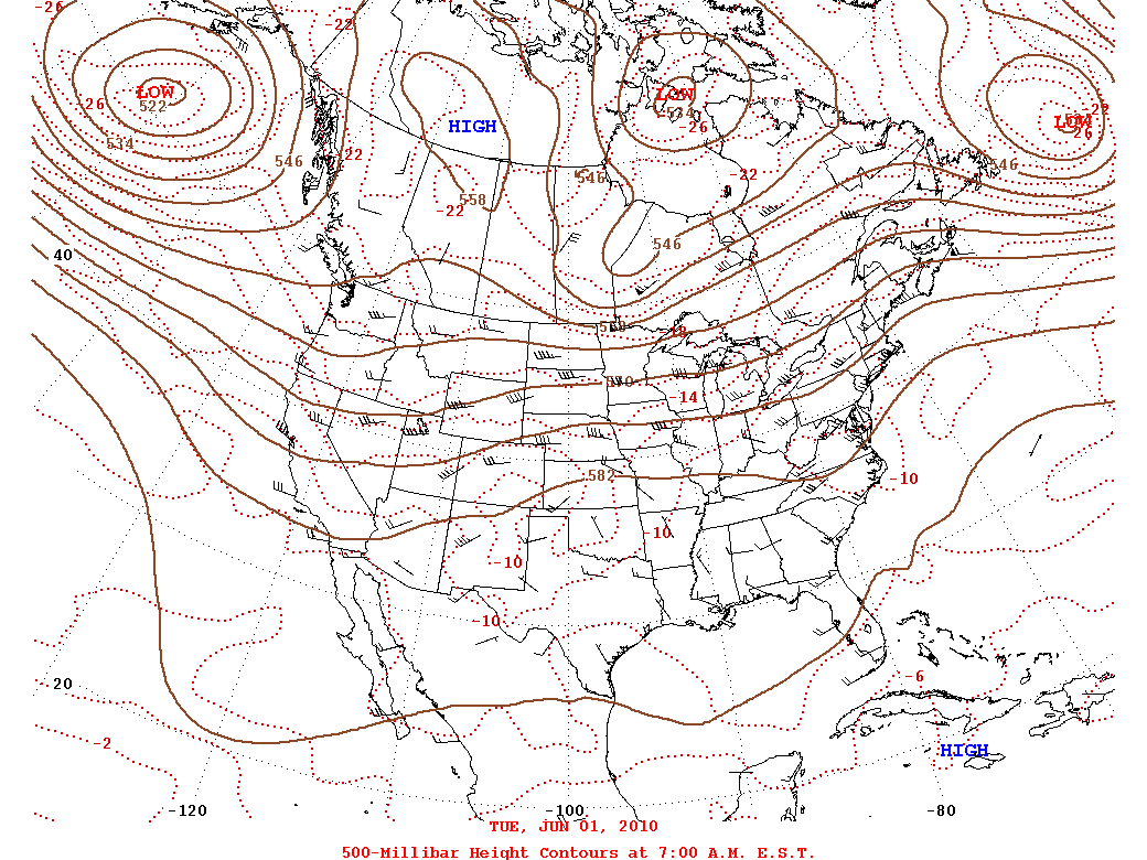 weather pattern for June 2010 was dominated by the North Atlantic High over the eastern and southern United States and an upper-level trough over the northwestern quarter of the country. This pattern directed the storm track across the central and northern tier states. Cooler- and wetter-than-average weather was associated with the trough in the Pacific Northwest, and weather systems moving in the storm track brought record and near-record wet conditions to several central states. The wettest June on record improved drought conditions in
  Michigan, with a near-record wet June occurring in
  Iowa,
Iowa,  Illinois, and
  Nebraska. Weather systems moving along the storm track generated an above-average number of tornadoes this month. A couple particularly potent low pressure systems developed in the West at mid-month and moved into the Plains and Midwest, bringing severe weather and flooding rains. The North Atlantic High (also known as the Bermuda High) delivered sunny, dry, and
 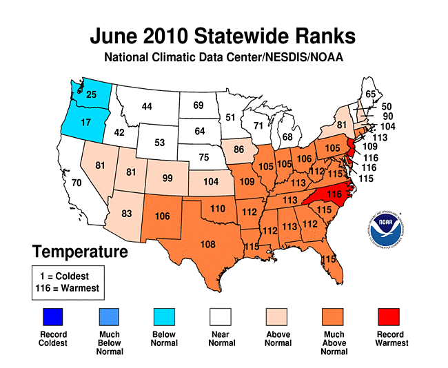 hot weather to much of the Gulf and Atlantic coast states and into the Midwest. New daily high temperature records were set in many cities, with June 2010 ranking as the hottest June on record for
  Delaware,
  New Jersey, and
  North Carolina. A few cold fronts managed to penetrate into the Southeast and mid-Atlantic states, but widespread frontal precipitation was inhibited by the descending air associated with the Bermuda High. The High also blocked tropical systems from entering the Southeast. Several Southeast and mid-Atlantic states had a
 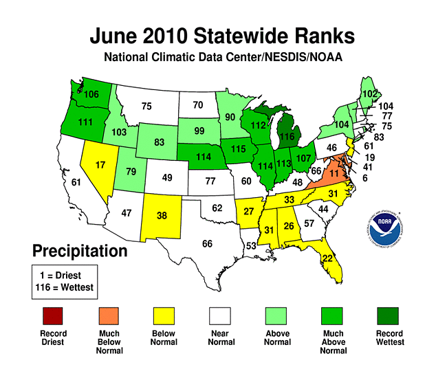 drier-than-normal June, with Maryland ranking as sixth driest. The easterly flow along the southern edge of the North Atlantic High guided the first named storm of the 2010 Atlantic hurricane season, Hurricane Alex, across the Caribbean and Gulf of Mexico into southeast Texas and northeast Mexico. NOAA's Residential Energy Demand Temperature Index (REDTI) measures temperature-related energy demand for the contiguous United States. The unusual warmth in the highly populated South and Southeast resulted in the second highest June REDTI value in the 116-year record. For the first half of 2010, large footprints of extreme wetness (more than three times the average footprint), warm minimum temperatures ("warm overnight lows"), and areas experiencing heavy 1-day precipitation events resulted in a Climate Extremes Index (CEI) that was about 6 percent higher than the historical average.
- Temperature Highlights - June
- The
 nationally-averaged temperature for June was much warmer than normal. A deep layer of high pressure dominated much of the
  eastern United States during the month. The southerly influx of warm air contributed to record high temperatures in many cities.
 - The
 Southeast,
  South and
  Central regions experienced their second, fifth and seventh warmest June on record, respectively. Only the
 Northwest had an average temperature below normal for the month.
 - Record-warm June temperatures were observed in
 Delaware,
  New Jersey and
  North Carolina (tied), where each had average temperatures 5 to 6 degrees F above the long-term mean. Many other states ranked in their top ten based on 116 years of data. Only
  Oregon and
  Washington had below normal monthly average temperatures for the month.
 - Midway through 2010, four New England states (
 Maine,
  New Hampshire,
  Vermont and
  Rhode Island) have experienced their warmest January-June period on record. Eight other states in the Northeast and Great Lakes areas had a top-ten warm such period. In contrast,
  Florida observed its seventh-coolest year-to-date on record.
 - Persistent warmth made the year's second quarter (April-June) much warmer than normal for
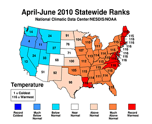 every state east of the Mississippi River, and several to its west.
  Louisiana and ten Atlantic Seaboard states (
 Maine,
  New Hampshire,
  Massachusetts,
  Delaware,
  Rhode Island,
  Connecticut [tied],
  New Jersey,
  Maryland,
  Virginia, and
  North Carolina) had a record-warm second quarter. In all, twenty states had their warmest or second-warmest such period on record. The warmth in these areas contributed to both the
  Northeast and
  Southeast climate regions' warmest April-June period.
 - There were significantly
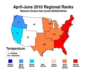 cool conditions in the West and Northwest.
  Oregon (4th coolest) and
  Idaho (11th coolest) had much below normal temperatures for April-June which led to the
  Northwest climate region's ninth coolest on record.
 - Precipitation Highlights - June
- The prevailing high pressure that brought warmth to the South and Southeast also blocked many storm systems from entering those
 regions, increasing the threat of drought there. However, the active upper-level pattern in the
 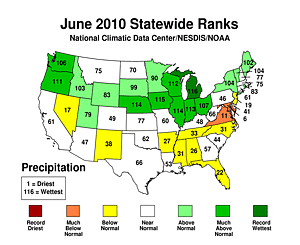 northern tier states helped to alleviate persistent drought conditions and produce record flooding in the High Plains.
 - June precipitation was the wettest on record for
 Michigan. Several other states were also anomalously wet, including:
  Iowa (2nd wettest),
  Nebraska and
  Illinois (3rd wettest),
  Indiana (4th wettest),
  Wisconsin (5th wettest),
  Oregon (6th wettest), and
  Ohio (10th wettest). Meanwhile,
  Maryland and
  Virginia experienced much below average precipitation for June.
 - Regionally, the
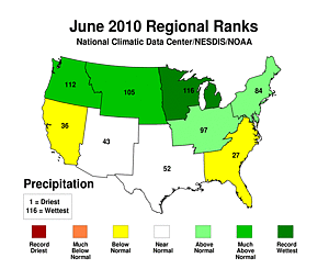
 East North Central climate region had its wettest June and the
  Northwest had its fifth wettest.
 - Precipitation during the year's second quarter
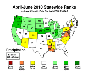 (April-June) was more widespread as
  Iowa and
  Washington each had its second wettest such period. It was
  Oregon's fourth and
  Nebraska's ninth wettest while persistent dryness in
  Maryland,
  Delaware and
  New Jersey resulted in their seventh, ninth and tenth driest such periods, respectively.
 - Other Items of Note
- Hurricane Alex, the first Atlantic June hurricane since 1995, affected portions of southern Texas on June 30th, making landfall 110 miles south of the US-Mexico border. Alex had sustained winds of 105 mph, marking the most intense Atlantic hurricane during June since Hurricane Alma in 1966. More information on tropical cylone activity during the month of June can be found on NCDC's Hurricanes and Tropical Storms Page
- NCDC's Climate Extremes Index (CEI) for January-through-June 2010 was about 6 percent higher than the historical average. The CEI measures the occurrence of several types of climate extremes, like record or near-record warmth, dry spells, or rainy periods. Factors contributing to the elevated 2010 value were large footprints of: extreme wetness (more than three times the average footprint), warm minimum temperatures ("warm overnight lows"), and areas experiencing heavy 1-day precipitation events.
- According to NOAA's Storm Prediction Center, there were 387 preliminary tornado reports during June. If confirmed, this will be the second most active June on record — behind 1992. Minnesota had a particularly busy month with 67 preliminary tornado reports, besting the previous record of 35 tornadoes during June 2005.
- Drought coverage decreased slightly in June. The U.S. Drought Monitor reported 8.5 percent of the United States was affected by drought on June 29th. Slight improvements were seen in the Northern Rockies and western Great Lakes, while conditions deteriorated in Louisiana and Texas.
- Based on NOAA's Residential Energy Demand Temperature Index (REDTI), the contiguous U.S. temperature-related energy demand was 11.9 percent above average for June. The unusual warmth in the highly populated South and Southeast contributed in the second highest June REDTI value in 116 years.
 nationally-averaged temperature
 Southeast
 South
South Central
 Northwest
 Oregon
 Washington
 Maine
Maine New Hampshire
 Vermont
 Rhode Island
 Florida
 every state
 Louisiana
 Maine
Maine New Hampshire
 Massachusetts
 Delaware
 Rhode Island
 Connecticut
 New Jersey
 Maryland
 Virginia
 North Carolina
 Northeast
 Southeast
 cool conditions
 Oregon
 Idaho
Idaho Northwest climate region's
 regions
 Indiana
 Wisconsin
 Oregon
 Ohio
Ohio Maryland
 Virginia
 East North Central
 Northwest
 (April-June)
 Iowa
Iowa Washington
 Oregon's
 Nebraska's
 Maryland
 Delaware
 New Jersey
Beginning with January 2010 processing, the Alaska temperature and precipitation report is comprised of several datasets at NCDC, integrating GHCN and COOP datasets. Prior to 2010, the Alaskan temperature timeseries was processed with just GHCN data.
-
 Alaska
had its 31st coldest June since records began in 1918, with a
temperature 1.4°F (0.8°C) below the 1971–2000
average.
Alaska
had its 31st coldest June since records began in 1918, with a
temperature 1.4°F (0.8°C) below the 1971–2000
average.
-
 Alaska
had its 26th warmest spring (March–June) on record, with a
temperature 1.1°F (0.6°C) above the 1971–2000
average.
Alaska
had its 26th warmest spring (March–June) on record, with a
temperature 1.1°F (0.6°C) above the 1971–2000
average.
-
 Alaska
had its 28th warmest year–to–date on record, with a
temperature 1.1°F (0.6°C) above the 1971–2000
average.
Alaska
had its 28th warmest year–to–date on record, with a
temperature 1.1°F (0.6°C) above the 1971–2000
average.
-
 Alaska
had its 26th wettest June since records began in 1918, with
an anomaly that was 4.2 percent above the 1971–2000
average.
Alaska
had its 26th wettest June since records began in 1918, with
an anomaly that was 4.2 percent above the 1971–2000
average.
-
 Alaska
had its 46th driest April–June on record, with
an anomaly that was 1.8 percent above the 1971–2000
average.
Alaska
had its 46th driest April–June on record, with
an anomaly that was 1.8 percent above the 1971–2000
average.
-
 Alaska
had its 18th driest year–to–date on record, with
an anomaly that was 13.1 percent below the 1971–2000
average.
Alaska
had its 18th driest year–to–date on record, with
an anomaly that was 13.1 percent below the 1971–2000
average.
For additional details about recent temperatures and precipitation across the U.S., see the Regional Highlights section below. For information on local temperature and precipitation records during the month, please visit NCDC's Records page. For details and graphics on weather events across the U.S. and the globe please visit NCDC's Global Hazards page.
Regional Highlights:
These regional summaries were provided by the six Regional Climate Centers and reflect conditions in their respective regions. These six regions differ spatially from the nine climatic regions of the National Climatic Data Center.
- Northeast Region: (Information provided by the Northeast Regional Climate Center)
- June 2010 was the 6th consecutive month with above normal temperatures in the Northeast and the 18th warmest June in 116 years. The region averaged 67.3 degrees F (19.6 degrees C), which was 2.2 degrees F (1.2 degrees C) above normal. Departures increased from north to south and ranged from 0.3 degrees F (0.2 degrees C) below normal in Vermont to 5.8 degrees F (3.2 degrees C) above normal in Delaware. It was the warmest June since 1895 in Delaware and New Jersey, the 2nd warmest in Maryland, the 4th warmest in Rhode Island and the 5th warmest in West Virginia. All but three of the first order stations in the Northeast had a monthly average that was in the top 25 warmest on record; of these, Dulles Airport, Virginia, Washington, DC, Atlantic City, New Jersey, Islip, New York, JFK Airport, New York, LaGuardia Airport, New York and Philadelphia, Pennsylvania had their warmest June on record.
- Rainfall in the Northeast averaged above normal in June, however, the totals were quite variable, with above normal rainfall in the west and north and dry conditions in the southeastern third of the region. The regional total was 4.30 inches (109 mm) and this was 106 percent of normal. Vermont, Maine and New York were the wettest states, with 141, 136 and 131 percent of normal rainfall, respectively. It was the 13th wettest June since 1895 in Vermont and New York and the 15th wettest in Maine. Maryland, on the other hand, had its 6th driest June in 116 years with only 53 percent of the normal rainfall amount. Four consecutive months of below normal precipitation in Pennsylvania and three consecutive drier than normal months in Connecticut, Delaware, Maryland, Massachusetts and New Jersey have resulted in some drought concerns as of June 29, 2010. According to the U.S. Drought Monitor of that date, all of New Jersey and Delaware, parts of southern New York, eastern and southern Pennsylvania, eastern West Virginia and most of Maryland were abnormally dry, while the southernmost part of Maryland was under moderate drought conditions.
- Severe weather at the end of June spawned EF1 tornados on the 22nd in Bradford, County, PA, on the 24th in Bridgeport, Connecticut, on the 27th in Warren County, Pennsylvania and an EF0 tornado on the 28th in Oswego, New York. Due to the downtown location, the Bridgeport, Connecticut tornado caused the most damage as winds up to 110 mph (49 m/s) blew in windows, tore off roofs, sheared treetops and left portions of the city littered with debris. At least 3 injuries were reported. Also on the 24th, a wind gust of 75 mph (33 m/s) was recorded at the Philadelphia airport as storms whipped through the area. This was the third highest gust recorded at that location.
- For more information, please go to the Northeast Regional Climate Center Home Page.
- Midwest Region: (Information provided by the Midwest Regional Climate Center)
- June temperatures were within 2 degrees F (1 degrees C) of normal in Iowa, Minnesota, Wisconsin, and Michigan. To the south, temperatures were warmer with departures reaching 5 to 7 degrees F (3 to 6 degrees C) above normal in southeast Missouri. Missouri experienced its warmest June since 1953, ranking as the 7th warmest June in the past 116 years.
- June precipitation was above normal for most of the Midwest. Only southern Missouri, western and central Kentucky, extreme northeast Ohio, and parts of northwest Minnesota saw below normal precipitation. Only southern Missouri received less than 75 percent of normal with southeast Missouri the driest as some locations got less than a quarter inch (6 mm) for the month. On the other hand, parts of several states got at least twice their normal rainfall. Most of Iowa, central Illinois, central Indiana, northern Missouri, and parts of Minnesota, Wisconsin, and Michigan received 200 percent or more of normal. Iowa's preliminary statewide total of 10.34 inches (263 mm) would top the old June record of 10.33 inches (262 mm) set in 1947 and would rank second to July 1993's 10.50 inches (267 mm) for any month. Eight stations in Iowa, with periods of record ranging from 53 to 123 years, set new records for any month. Indianola, 16.86 inches (428 mm) was the highest new total breaking its old record of 15.26 inches (388 mm) from June of 1947. The driest station in Iowa was Sidney which received 5.44 inches (138 mm) which is still 1.22 inches (31 mm) above normal.
- June was a deadly month in the Midwest with 11 deaths related to the weather. Ten died in five tornadoes on three days and another died in a severe thunderstorm. After dark on June 5th, a tornado tore through Millbury, Ohio killing six people. A tornado outbreak in eastern North Dakota and Minnesota on the 17th spawned at least 20 tornadoes, including three in Minnesota that were each blamed for a death. On the 27th, a tornado hit a campground in St. Clair County, Michigan killing a camper. The eleventh weather related death in the Midwest occurred on the 18th when a severe thunderstorm felled a tree onto an occupied car in Indiana. June was a busy month for severe weather in the Midwest with more than 2000 reports of severe weather and only three quiet days without a report (7th, 29th, and 30th).
- Flooding in Iowa and surrounding states has largely spared urban areas. Though the flooding is widespread it has not yet been as devastating as 1993 or 2008. Mitigating factors are the warm weather that has increased evapotranspiration, rainfall that has fallen throughout the month rather than in a shorter time period, and that the rain has been spread evenly across a large area rather than being more localized.
- June rains improved drought conditions in the Upper Midwest. Multi-year precipitation deficits and the low lake levels they caused remain but the shorter-term conditions are much improved.
- For details on the weather and climate events of the Midwest, see the weekly summaries in the MRCC Midwest Climate Watch page.
- Southeast Region: (Information provided by the Southeast Regional Climate Center)
- June was an exceptionally warm month across the Southeast owing to a deep ridge of high pressure that remained anchored over the region for most of the month. Mean temperatures ranged from 2 degrees F above normal along the Florida Panhandle to over 7 degrees F above normal across central North Carolina and Virginia. Mean temperatures for the month were near normal across Puerto Rico. Over 60 locations in the Southeast experienced their warmest June on record, including Miami, FL, Key West, FL, Raleigh-Durham, NC, Charleston, SC, Roanoke, VA, and Washington, D.C. Across the region, 480 record daily maximum temperatures were tied or broken during the month. June 14th marked only the fifth time ever in a record extending back to 1948 that the temperature reached the century mark (100 degrees F) at the Orlando Executive Airport in Florida. The persistence of the warm weather across the region in June was also noteworthy. Greenville-Spartanburg, SC, and Charlotte, NC, both experienced 18 consecutive days (from the 12th to the 29th) in which the maximum temperature equaled or exceeded 90 degrees F (32 degrees C). This is the longest streak of 90 degree F and higher maximum temperatures in June at either location. Continuing the trend from May, overnight temperatures were unusually warm in June. In fact, there were over 1,000 record daily high minimum temperatures tied or broken across the region. Sterling, VA registered a minimum temperature of 75 degrees F (24 degrees C) on the 29th of the month, which set the record for the warmest minimum temperature for any day in June. North Myrtle Beach, SC experienced a streak of 21 days between the 10th and 30th of the month in which the daily minimum temperature equaled or exceeded 70 degrees (21 degrees C), a new record for June.
- Precipitation totals were below normal across the Southeast in June. However, localized areas that experienced more thunderstorm activity were near normal or slightly above normal. The wettest locations were found in southeast North Carolina, northeast South Carolina, and east-central Georgia, where precipitation for the month was between 150 and 250 percent of normal. New Bern, NC recorded nearly 9 inches (229 mm) of precipitation for the month, its second highest June rainfall total in a record extending back to 1948. The 2010 calendar year continues to be exceptionally wet across Puerto Rico; monthly precipitation totals were over 200 percent of normal along the southern end of the island in June. In contrast, precipitation totals were less than 50 percent of normal across broad portions of Virginia, while precipitation totals in the northern and southeast parts of the state were less than 25 percent of normal. Clarksville, VA received 0.65 inches (16.5 mm) of precipitation for the month, which was only 16 percent of normal. Outside of Virginia, the driest locations across the Southeast (less than 25 percent of normal) were along the immediate coast from the Outer Banks of North Carolina to the southern tip of Florida, east-central Alabama, and northwest South Carolina.
- There were 962 reports of severe weather across the Southeast in June. For the second straight month, there was a paucity of tornado reports in the region. Only two tornadoes were reported in June, both on the 20th of the month as part of a line of strong storms that moved over Fort Myers and Cape Coral, FL. Only minor roof damage was reported. High winds were the primary threat from severe thunderstorms during the month (93 percent of all reports) as a dry lower troposphere supported evaporative cooling and strong downdrafts. On the 2nd of the month, a man pushing a baby in a carriage was injured when lightning struck a nearby rock on Kennesaw Mountain in northern Georgia. The baby was not injured.
- Despite the lack of rainfall across much of the Southeast, there were no areas displaying drought conditions (D1 or greater) during the month. By the end of the month, abnormally dry (D0) conditions had developed throughout much of Virginia, northeast North Carolina, and northwest South Carolina where precipitation deficits were the greatest. Abnormally dry conditions also developed in the mountains of North Carolina. The combination of warmth and wetness throughout much of central Georgia likely contributed to the development of a soil fungus known to kill watermelon seedlings. As a result, watermelon growers in the region were anticipating up to a 50 percent loss on the crop.
- For more information, please go to the Southeast Regional Climate Center Home Page.
- High Plains Region: (Information provided by the High Plains Regional Climate Center)
- June 2010 temperatures were near normal for most locations across the High Plains Region. Colorado and Kansas were the exceptions with both states having temperature departures of 2-4 degrees F (1.1-2.2 degrees C) above normal with pockets of temperature departures of 4-6 degrees F (2.2-3.3 degrees C) above normal. Only small areas of Wyoming, South Dakota, and North Dakota had temperature departures of 2-4 degrees F (1.1-2.2 degrees C) below normal. These temperature departures caused many locations across Kansas and eastern Colorado to be ranked in the top 10 warmest Junes on record. Topeka, Kansas recorded its 7th warmest June with an average temperature of 78.7 degrees F (25.9 degrees C). This could not beat out the warmest June on record which occurred in 1934 with an average temperature of 82.3 degrees F (27.9 degrees C) (period of record 1887-2010). Meanwhile, Colorado Springs, Colorado recorded its 5th warmest June with an average temperature of 69.6 degrees F (20.9 degrees C) which was 5.2 degrees F (2.9 degrees C) above normal. The warmest June in Colorado Springs occurred in 2002 when an average temperature of 70.8 degrees F (21.6 degrees C) was recorded (period of record 1894-2010).
- June 2010 was a wet month for much of the High Plains Region as a large swath extending from Wyoming, into Nebraska, and South Dakota received over 200 percent of normal precipitation. Areas of central and eastern Nebraska received over 300 percent of normal precipitation. The heavy rains led to flooding along many rivers and also in fields. Record flooding occurred on the Elkhorn River at Norfolk, Nebraska when the river crested at 16.85 feet on June 16th. The heavy rains also slowed crop progress and delayed field work. In addition to heavy rains, severe weather was reported almost every day of the month in the Region. A major tornado outbreak occurred on June 17th and at least 20 tornadoes were confirmed in eastern North Dakota and northwestern Minnesota. Numerous locations throughout Nebraska, South Dakota, Kansas, and Wyoming ranked in the top 10 wettest Junes on record and many recorded their wettest June on record. This month's wet spot was Ericson 6 WNW, Nebraska which is located in central Nebraska. Ericson 6 WNW received 12.93 inches (328.42 mm) of precipitation which is 9.37 inches (238.00 mm) above normal, or 363 percent of normal precipitation. This beat the old record of 9.32 inches (236.73 mm) which was recorded in 1908 (period of record 1893-2010). In addition, 4.26 inches (108.20 mm) of the monthly total precipitation fell in one day, June 13th. This heavy precipitation crushed the record for the most one-day precipitation received during the month of June. The old record was 3.50 inches (88.90 mm) received June 14, 1920. Also, the June 13th rainfall went down as the second highest one-day precipitation total ever recorded at Ericson 6 WNW. The record one-day precipitation total was set August 12, 1966 when 5.80 inches (147.32 mm) of precipitation fell.
- June brought only minor changes to the Drought Monitor. North Dakota, South Dakota, Nebraska, and Kansas remained drought free this month. However, little to no precipitation fell in southern Colorado which led to the development of abnormally dry conditions (D0). D0 in northern Colorado persisted and D0 and moderate drought conditions (D1) in western Wyoming remained largely unchanged this month. However, in the northwest corner of Wyoming, the severe drought conditions (D2) were downgraded to D1 and D0. Even with this improvement, according to the U.S. Seasonal Drought Outlook released June 17th, the drought conditions in western Wyoming are expected to persist through September 2010.
- For more information, please go to the High Plains Regional Climate Center Home Page.
- Southern Region: (Information provided by the Southern Regional Climate Center)
- It was a generally warm June for much of the Southern Region. The warmest state was Arkansas, which averaged 4-8 degrees F (2.2-4.4 degrees C) above the monthly average. Similar anomalies were also observed in Tennessee, northern Louisiana, and central and northern Mississippi. Elsewhere, temperature conditions in southern Texas were only 0-2 degrees F (0.0-2.2 degrees C) above normal. In total, the six states combined had an monthly average temperature of 81.95 degrees F (27.8 degrees C), making it the fourth warmest June on record (1895-2010) for the entire region. With a monthly average temperature of 78.60 degrees F (25.9 degrees C), Tennessee experienced its fourth warmest June on record (1895-2010). Both Arkansas and Mississippi reported their fifth warmest June on record (1895-2010), with monthly average temperatures of 81.70 degrees F (27.6 degrees C) and 82.00 degrees F (27.8 degrees C), respectively. Elsewhere, Louisiana reported a state monthly average temperature of 83.40 degrees F (28.6 degrees C), which was the second warmest June on record (1895-2010). Oklahoma reported its seventh warmest June on record with a monthly average temperature of 80.60 degrees F (27.0 degrees C), while Texas reported a monthly average temperature of 82.60 degrees F (28.1 degrees C). for Texas, it was the ninth warmest June on record (1895-2010).
- June Precipitation totals in the Southern Region varied dramatically from state to state, and from climate division to climate division. The majority of the stations in the region reported values for the month that varied between 70 and 110 percent of normal. Relative to the monthly normals, the wettest areas of the region occurred in eastern Oklahoma, where many stations recorded between 150 to 200 percent of normal. Similar values were also observed in east central Texas, western Texas and southwestern Louisiana. The driest location within the region was eastern Arkansas, where most stations reported less than half the monthly allotment. There were many similar pockets of dryness in: western Oklahoma, Southern Texas, and northwestern Mississippi.
- Drought conditions in the Southern Region have significantly changed over the past month. Areal coverage of moderate drought or worse in the Southern Region has increased from 12 percent to 14.1 percent. New drought locations include north central Texas, southern Arkansas, and the northwestern Mississippi border. In addition, conditions have worsened in northern Louisiana, which is now showing extreme drought (D3) conditions. The D3 area makes up 1.5 percent of the Southern Region and 16.8 percent of the state of Louisiana.
- On June 8 and 9, flash flooding occurred in south central Texas, leading to at least one fatality. A slow moving storm passed through the San Antonio and New Braunfels area. According to UPI.com, a total of 11 inches (279.4 mm) of rainfall was reported in the San Antonio area, however; this value could not be confirmed. New Braunfels reported a storm total of 6.59 inches (167.4 mm) of precipitation. The wettest station in the state in the window of June 7 - June 11 was Tyler, Texas, which received 9.66 inches (245.4 mm) of precipitation.
- In southwestern Arkansas, heavy rainfall from June 10-11, 2010 led to major flooding in the Ouachita National Forest. Flooding caused both the Little Missouri River and the Caddo River to rise over 20 feet (6.1 m) in stage. Reports indicate that the Little Missouri River reached a peak stage of 23 feet (7 m). The flooding led to 20 known fatalities, six of which were children. The casualties are believed to be high because the flooding affected a remote camping site where campers may not have been able to heed the issued flood warnings. Precipitation totals in the Southwest Climate division for the two day period show that many stations received over 4 inches (101.6 mm). The station at Athens, Arkansas reported a two day total of 9.12 inches (231.6 mm), while the stations at Glenwood, Hopper, and Langley reported 7.55 (191.8 mm), 7.48 (190 mm), and 7.74 inches (196.6 mm), respectively.
- Hurricane Alex made landfall on the evening of June 30, 2010 as a category 2 storm, packing winds of 105 mph (165 km/hr). Because Hurricane Alex made landfall in northern Mexico (Soto la Marina), the northern side of the hurricane caused heavy rainfall and high winds on South Padre Island. Several tornadoes were spawned in the area, which resulted in the overturning of a mobile home. On June 30, Brownsville Airport reported 5.86 inches (149 mm) of rainfall. In McAllen, Texas, a total of 6.66 inches (169 mm) was received on the 30th of June. As the storm pushed inland, heavy rainfalls in western Texas led to record stages on the Rio Grande river at the Foster Ranch river reach. Reports indicate the that stage exceeded 31 feet (9.4 m), which set a new stage record.
- For more information, please go to the Southern Regional Climate Center Home Page.
- Western Region: (Information provided by the Western Regional Climate Center)
- Temperatures throughout the West were 1 to 4 degrees F (0.5 to 2.5 deg C) below normal in the northern tier with the Northwest having the coolest temperatures. In the southern portions of the West, temperatures were generally 1 to 4 degrees F (0.5 to 2.5 deg C) above normal with portions of New Mexico having the greatest positive departures. A persistent marine layer blanketed the south coast of California leading to a particularly cool and gray June. San Diego recorded their coolest June in 11 years. Not a single day there during the month had a positive temperature departure and the range from the warmest to coolest day was only 5 degrees F (3 deg C).
- Precipitation was well above normal in the Pacific Northwest, near normal in the Intermountain and very low in the Southwest. A new record June rainfall total of 4.27 inches (108.5 mm) fell in Portland, Oregon. It was the wettest June in Billings, Montana, since 1991. One exception in the dry Southwest was Roswell, New Mexico. Their total of 4.21 inches (107 mm) was the most in June since 1986. An unusually strong late season rain event hit northwest California and southwest Oregon early in the month (see below) leading to the wettest June in over 70 years in some locations.
- June 2-4: Heavy Rain in the Northwest: Strong late season storms dumped up to 13 inches (330 mm) of rain over a 3-day period in SW Oregon and NW California. The combination of heavy rain and rapid mountain snowmelt caused widespread flooding in parts of eastern Oregon and western Idaho and also caused the closure of some campgrounds and highways in anticipation of rock slides and flooding.
- June 9-15: Flooding in Wyoming: Heavy precipitation and rapid snowmelt led to flooding in many parts of Wyoming. The Little Wind River at Riverton set a new record stage and remained above flood stage for numerous days. An estimated 32 square miles of land has been flooded in Fremont County with a few homes and mobile home parks in Saratoga under water. A bridge in Lander had to be closed after it was found to be unsound due to high water.
- June: Wildfires in AZ and NM: The Schultz fire north of Flagstaff, Arizona, was started by an abandoned campfire and quickly spread due to very dry, hot and windy conditions. As of June 30th, the fire was 90 percent contained and had burned over 15,000 acres. Luckily, no homes were destroyed. The South Fork Fire, near Los Alamos, New Mexico, was caused by lightning on June 10th and has burned over 17,000 acres by the 30th with only 50 percent containment. Again, no structures were burned.
See NCDC's Monthly Records web-page for weather and climate records for the month of May. For additional national, regional, and statewide data and graphics from 1895-present, for any period, please visit the Climate at a Glance page.
PLEASE NOTE: All of the temperature and precipitation ranks and values are based on preliminary data. The ranks will change when the final data are processed, but will not be replaced on these pages. Graphics based on final data are provided on the Climate Monitoring Products page and the Climate at a Glance page as they become available.