Climate Extremes Index | Tornadoes | Tropical Cyclones | Snow
Map of U.S. Climate Regions | Map of U.S. Climate Divisions

2010 National Events Map
Click for more information
Issued January 12, 2011: The data presented in this report are final through September and preliminary from October-December. Ranks, anomalies, and percent areas may change as more complete data are received and processed.
National Overview
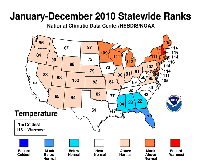

In 2010, the contiguous United States (CONUS) average annual temperature of 53.8 degrees F (12.1 degrees C) was 1.0 degrees F (0.6 degrees C) above normal, and was the 23rd warmest year on record. Since 1895, the CONUS has observed a long-term temperature increase of about 0.12 degrees F (0.07 degrees C) per decade. Precipitation across the CONUS in 2010 was 1.02 inches (25.9 mm) above the long-term average (LTA). Over the long-term, precipitation averaged across the CONUS, is increasing at a rate of about 0.18 inches (4.6 mm) per decade.
Seasonal highlights in 2010 included a winter with abnormally cold temperatures and abundant moisture, which resulted in a historic December-February period in the East and Northeast. Several locations broke monthly and seasonal snowfall records. During the spring period, record warmth dominated much of the Northeast contributing to the limited amount of snow fall across the country. Satellite measurements indicated that the U.S. had its 8th smallest April snow cover extent in the 44-year period of record. The North Atlantic High played a large role in the summer weather pattern along the east coast, contributing to record heat in the South and East. A persistent storm track brought prolific summer rains to the Northern Plains and Upper Midwest. The number of tornadoes, as reported by the Storm Prediction Center (SPC), during the summer was abnormally high—sixth busiest in 60 years. Drought conditions, while record low at the beginning of the summer period, expanded in area by late summer. Nonetheless, the U.S. footprint of drought reached its smallest extent which help limit wildfire activity in 2010. For the second consecutive year, no hurricanes made landfall in the U.S., despite the active tropical cyclone season in the Atlantic Basin.
This annual report places the temperature and precipitation averages into historical perspective, while summarizing the notable events that occurred in 2010. More detailed analysis on individual months can be found through the Climate Monitoring home page.
Top Ten U.S. Weather/Climate Events for 2012
| Rank | Event |
|---|---|
| 1 | Consecutive Winter Blizzards/ Extreme Snow Season |
| 2 | Nashville and Central TN flooding |
| 3-tie | Hot Summer in the East |
| 3-tie | Midwest Super Storm |
| 5 | Hawaiian Drought |
| 6 | No hurricanes made U.S. landfall despite active Atlantic |
| 7 | Near Eradication of CONUS Drought |
| 8 | Vivian, SD Hailstone |
| 9 | New England Flooding |
| 10 | Minnesota as tornado leader |
Temperature and Precipitation Seasonal Analysis
Winter
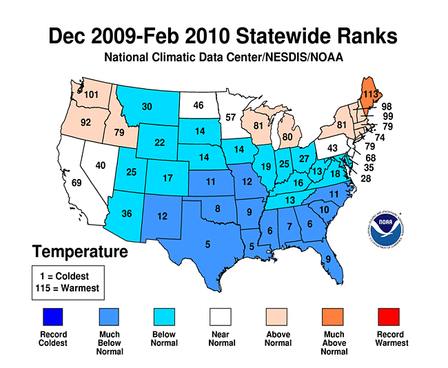
The 2009/2010 winter season was marked by anomalously cold air in the South and East. Temperatures for the three-month period (December–February) were dominated by the historically strong negative phase of the Arctic Oscillation (AO). The negative AO allowed cold Arctic air to slide south while warmer air was displaced to the north. This created warmer-than-normal conditions in some of the Northeast, Great Lakes and Northwest, while below to much-below-average temperatures were present from the Rockies eastward into the Mid-Atlantic. The coldest temperature anomalies for the period occurred in the Southeast and Southern Plains. Florida was greatly affected by the persistence of the cold air. In January, its citrus crop sustained heavy damages from sub-freezing temperatures as an estimate by the U.S. Department of Agriculture totaled the crop losses to be more than $450 million. Florida then experienced its fourth coldest February on record. Temperature anamolies were nearly eight degrees F (4.4 degrees C) below the 20th average. Meanwhile, Maine had its third warmest winter, nearly six degrees F (3.3 degrees C) above the 20th century average. The average winter temperature across the contiguous U.S. was 1.8 degrees F (1.0 degrees C) below the 20th century average, or 15th coolest on record.
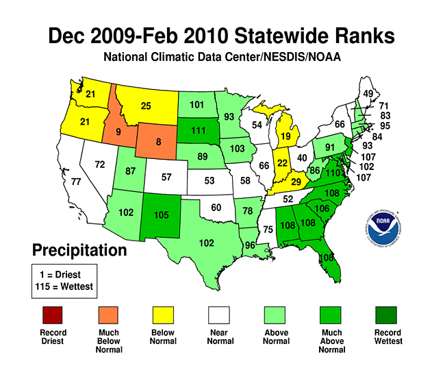
The strong presence of El Niño coupled with the negative AO, greatly influenced the jet streams and general weather pattern across the U.S. during the winter period. The average precipitaton for the period was 0.88 inch (22 mm) above normal partly due to a series of winter storms that were generated by the subtropical and polar jets. As a result of the persistent pattern, much of the South, East, and Upper Midwest experienced above to much-above-normal precipitation. One of the note-worthy events during the season were the back-to-back winter storms that affected the Washington D.C. area in February. The first occurred on February 4th when the Reagan National Airport received 32.4 inches (82.3 cm) of snow, a record amount for that location. On February 9th-11th, while digging out from the previous storm, D.C. residents suffered through another storm as 10.5 inches (26.7 cm) of snow fell at the Reagan National Airport. While there were no record precipitation amounts statewide, monthly and seasonal snowfall records were shattered.
Spring
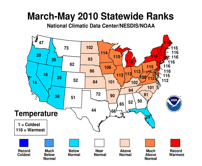

The nationally averaged temperature for the spring period (March-May) was 1.4 degrees F (0.8 degrees C) above the LTA. The season brought record warmth to the Northeast, which was 5.3 degrees F (2.9 degrees C) above normal. Eight northeastern states experienced their warmest such period on record: Connecticut, Rhode Island, Maine, Massachusetts, New Hampshire, New Jersey, New York, and Vermont. Michigan also had its warmest spring period. It was one of the ten warmest spring seasons for ten other states. Conversely, the majority of the western U.S. experienced temperatures that were 2-4 degrees F (1.1-2.2 degrees C) below normal during the spring season. A persistent pattern of a high pressure ridge (associated with warmer conditions) in the East and a western trough (cooler conditions) was especially evident during the period. Much of the coolness in western U.S. can be attributed to  unrelenting troughs which filtered in cool moist Pacific air during April and May.
As is typical, precipitation was variable throughout the country during the spring season (March–May) resulting in a near-normal value based on the LTA. Only three states were in the top or bottom tenth percentile. Louisiana had its fifth driest period while Rhode Island and Massachusetts had their second and tenth wettest period, respectively. During the period, warm conditions across the Northeastern quadrant of the country helped limit U.S. snowfall. Several cities in New York did not receive any snow during the month of March for the first time on record. Satellite measurements indicated that the U.S. had its 8th smallest April snow cover extent in the 44-year period of record, while North America as a whole had its smallest spring snow cover extent. As estimated by the U.S. Drought Monitor (USDM), the area of drought in the CONUS increased slightly from 8.8 percent at the beginning of March to 9.3 percent near the end of May. Flooding occurred in Nashville, Tennessee when a stagnant storm system brought more than 13.0 inches (330.0 mm) of rain to the area on May 1st-2nd. It was estimated that over $1 billion worth of damages were done. By the second day of the month, Nashville had recorded its wettest May and fifth wettest month on record.
Summer
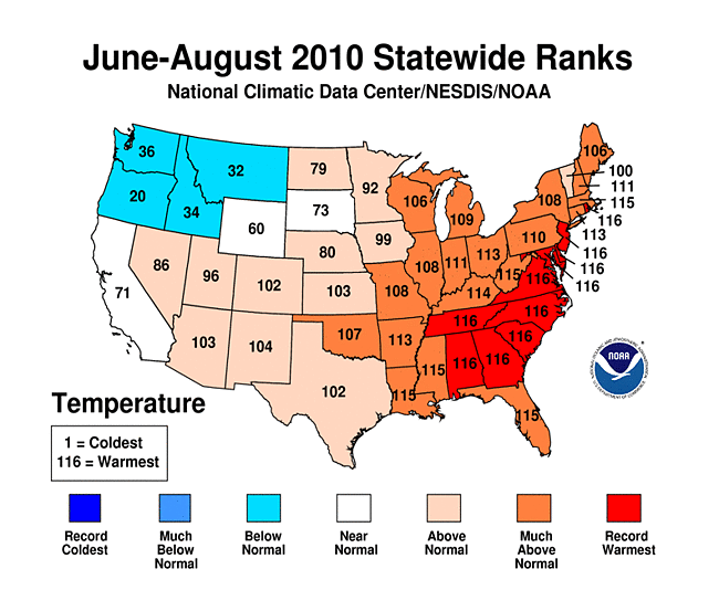

The summer of 2010 was marked by the persistent Bermuda High that parked itself in the western Atlantic. This area of high pressure was situated abnormally west ushering in warm humid conditions along the east coast and as far inland as the Midwest. This not only lead to record heat in a vast area of the country, but also acted as a block preventing smaller storm systems from entering into the regions. It was the hottest June on record for several states along the mid-Atlantic Coast as well as Louisiana. Nationally, it was the eighth warmest June and August on record. During the first week of July, an oppressive heat wave led to soaring temperatures throughout the eastern half of the CONUS. Hundreds of maximum high and minimum high temperatures were broken, contributing to the third and the fifth warmest July on record for the Southeast and Northeast climate regions, respectively. For the entire summer period (June-August), 12 states were record warm, while only two experienced average temperatures below normal. Overall, it was the fourth warmest summer on record for the CONUS with an average temperature of 1.9 degrees F (1.0 degrees C) above the 20th century average.
Despite record warm temperatures during the summer period, the nationally averaged precipitation was the ninth wettest in 116 years, 1.09 inches (27.7 mm) above the LTA. As a result of the persistent track of storm systems across the northern-tier states, areas around the Upper Midwest and Great Lakes had an anomalously wet summer. Wisconsin had its wettest June–August on record, while many other surrounding states, including Iowa, Michigan, Nebraska, South Dakota, Minnesota, and Illinois, had near record precipitation averages. New Jersey was the only state to experience a summer that ranked in the bottom ten percent (6th driest), based on data that date back to 1895. Regionally, both the West and Southeast had below-normal precipitation averages during the summer season.
Fall
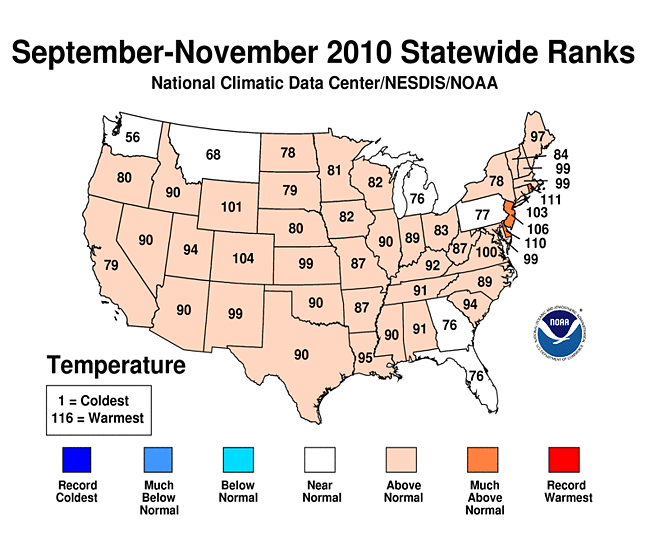

Warmer-than-normal temperatures were predominant throughout much of the country during the fall season (September–November). Based on divisional temperature averages, no state experienced a below-normal fall period. These conditions were mostly reflective of the above-average warmth during September and October, a result of the lingering Bermuda high in the Atlantic. The average fall temperature for the CONUS was 1.5 degrees F (0.8 degrees C) above the 20th century average, ranking 14th warmest. The constant lack of precipitation in Florida resulted in the second driest September-November period on record. Meanwhile, the tireless storm track over the upper Midwest resulted in much-above-normal precipitation for Minnesota and North Dakota. Maine, Vermont, and New Hampshire also averaged precipitation amounts that were among their wettest ten percent. Overall, precipitation when averaged nationally, was about average for the fall period.
Fall highlights consisted of:
- On September 27th Los Angeles, California experienced its all-time warmest day (113 degrees F or 45 degrees C) since record keeping began in 1877.
- Major flooding occurred along the Atlantic coast attributable to the remnants of Tropical Storm Nicole
- Severe weather caused eight tornadoes in a single day in Arizona, which only averages four per year
- A powerful low pressure system developed in the Upper Midwest and broke state records for lowest atmospheric pressure observed in Wisconsin
- Winter weather impacted areas in the Upper Midwest as Duluth, Minnesota had its sixth snowiest autumn on record.
Alaska Annual Summary


Alaska temperatures in 2010 were above the 1971-2000 average, continuing the upward trend of the last 20 years.
 Winter temperatures in 2009-2010 were 3.1 degrees F (1.7 degrees C) above average.
 Spring temperatures were 0.7 degrees F (0.4 degrees C) above average,
 summer was 0.4 degrees F (0.2 degrees C) above average, and
 fall was 3.1 degrees F (1.7 degrees C) warmer than the average.
Precipitation in Alaska in 2010 was near normal. While it was the fifth driest
 winter,
 spring was near normal.
 Summer precipitation was about 11 percent above the 1971-2000 average and
 fall precipitation was near normal.
In November, a widespread rain-event coupled with sub-freezing surface temperatures in Alaska resulted in a major ice storm. It was reported that the affected area was the combined sizes of Texas, Oklahoma, and New Mexico. The rainfall amount was the second largest daily rainfall amount between November and March in Fairbanks since record keeping began in 1904.
Very Warm/Cold and Wet/Dry Percentages
One way to assess the magnitude of warm/cold and wet/dry episodes is to compute the percent area of the contiguous United States that was "very warm/very cold" and that which was "very wet/very dry". The figures above depicts these values for each month in the past 30 years. These percentages are computed based on the climate division data set. Those climate divisions having a monthly average temperature/precipitation in the top ten percent (> 90th percentile) of their historical distribution are considered "very warm/very wet" and those in the bottom ten percent (< 10th percentile) are "very cold/very dry".
During 2010, the U.S. experienced an extremely cold winter which transitioned into a record breaking warm summer. In terms of the area of the contiguous U.S., 38 percent experienced temperatures that were in the bottom 10th percentile or categorized as "very cold" in December. This definition correlates well with "much below normal" in terms of NCDC ranking methods. The anomalously cold temperatures infiltrated into the U.S again in February when 27.4 percent of the country was categorized as "very cold". Influenced by a weakening El Niño and a strengthening Bermuda High, "very warm" conditions prevailed in the spring and culminated in the summer months. During April, June, and August at least 30 percent of the country experienced conditions that are categorized as "very warm".
Conditions that are categorized as "very wet" existed throughout the U.S. during January–December, resulting in a historically low drought footprint on July 6th. While the high pressure systems, which typically deliver very little precipitation, dominated the east, the persistant upper level jet stream over the northern tier states produced copious amounts of precipitation for the Upper Midwest. During six of the first seven months of the year (each month except March) conditions categorized as "very wet" prevailed over conditions categorized as "very dry". Furthermore, conditions categorized as "very dry" only existed for greater than 10 percent of the country during three months—March, September and December.
Lower Tropospheric

The 2010 temperature in the lower troposphere was slightly above-average. Data collected by NOAA's TIROS-N polar-orbiting satellites and adjusted for time-dependent biases by NASA and the Global Hydrology and Climate Center at the University of Alabama in Huntsville, indicate that temperatures in the lower half of the troposphere (lowest 8 km of the atmosphere) over the U.S. were approximately 0.2 degrees F (0.1 degrees C) above the 1979-1998 average.
Climate Extremes Index
The U.S. Climate Extremes Index (CEI) measures the occurrence of several types of climate extremes, such as record or near-record warmth, dry spells or rainy periods. During 2010, the most prominent and wide-spread extremes occurred during two seasons: winter and summer. At the National level, the winter season ranked as the 15th coldest winter on record, while the summer ranked as the 4th warmest based on records which date back to 1895. The change in seasonal temperatures was a record in the Southeast, which experienced its 11th coldest winter and its hottest summer on record. Winter precipitation was above average across the nation with the Southwest and the Southeast ranking among the top ten wettest such periods on record. Summer ranked 9th wettest for the nation, with the bulk of the precipitation occurring in the West North Central and East North Central regions.
For the contiguous U.S. (CONUS), the spatial extent of extremes, as depicted by the CEI, was approximately 6% greater than the historical average for winter (December 2009 - February 2010). Factors contributing to the elevated 2009-2010 winter value were large footprints of cold maximum temperatures, areas of extreme wetness as denoted by the Palmer Drought Severity Index (PDSI) and an abundance of days in which precipitation fell. The seasonal wetness can also be seen in the precipitation state rank map. Regions of the country which were most significantly impacted were the Central, South and Southeast regions. More than half of the Southeast region experienced extremes in cold maximum temperatures, excessive wet conditions and large 1-day precipitation events. Approximately one-third of both the Central and South regions experienced extremes in cold maximum temperatures, excessive wetness and a large number of days with precipitation. Other regions which had prologed periods of wetness were the West North Central, East North Central and the Northeast regions.
For as cold as the winter was in the Central, South and Southeastern regions, the summer months were filled with record warmth, primarily seen in the warm minimum temperatures. Approximately 30% of the CONUS was impacted by extremes during the summer (June August), which is 10% above the average spatial extent for extremes. Much of the credit for this above average value can be attributed to warmth in both maximum and minimum temperatures as well as excessive wetness across parts of the contiguous U.S. More than half of the East North Central region experienced extremes in warm minimum temperatures, excessive wetness, large 1-day precipitation values and a large number of days with precipitation. The Southeast region sweltered under large-scale heat in both maximum and minimum temperatures, which covered nearly the entire region during the summer months. Nearly all of the Northeast, Central, Southeast, South and East North Central regions experienced extreme warm minimum temperatures during this period. The Southwest and West North Central regions had large, yet less-extensive areas which experienced warm minimum temperatures during this period. Additional areas of extreme wetness were also seen in the West North Central, Northwest and Central regions.
In 2011, the regional CEI data and graphics will be updated on a monthly basis and accessible through the CEI webpage. Please visit our main CEI webpage for national CEI data as well as updates on the timing of the release of the regional CEI products.
Monthly National Snow and Ice Report

Much of the United States experienced a record breaking 2009–2010 winter. Long–standing monthly and seasonal snowfall records were shattered and record cold temperatures were set over the eastern two-thirds of the nation. According to 44 years of satellite data analyzed by the NOAA supported, Rutgers Global Snow Lab, a new monthly snow cover extent record was set during December 2009. This was partially due to snow falling across the Southern Plains, Gulf Coast, and the Southeast — regions which do not typically receive much December snowfall. Persistent cold and snow across much of the country during January and February was associated with those months ranking in their top ten largest snow cover extents for the U.S. — January was 6th largest and February 3rd largest. A far–reaching storm the second week of February brought snow to the Deep South, and every state in the U.S. had snow on the ground, including Florida and Hawaii. More information on the 2009–2010 winter can be found in the 2009–2010 Cold Season Special Report. As the season transitioned into spring, conditions were almost the complete opposite of the winter, with low snow cover extents reported across the United States during April (8th smallest) and May (10th smallest). The low spring snow cover extent was driven by anomalously warm conditions over the regions which had experienced the heavy snow during the December–February period.
Winter and spring mountain snowpack provide a crucial water source across much of the western United States. The total annual water budget for agriculture and human use in the mountainous West is based upon the amount of snow melt that will occur in spring and is proportional to the amount of snow on the ground. The annual snowpack typically reaches its maximum values at the end of March. During the 2009–2010 Cold Season, the West generally experienced much–below average snowpacks. Mountain snowpack in the Pacific Northwest was less than 25 percent of normal in several locations. The pattern was evident in the high-elevation station (SNOTEL) network, especially in maps of the end-of-March snowpack and snow water content. Some individual SNOTEL stations in the northern Rockies had early April snow water equivalent in the driest fifth percentile of the historical record (95 percent of the years for this date were wetter). Conversely, the snowpack was much above average in Arizona, New Mexico, and southern Utah.
In October, the cold season returned as well as snowy conditions across the United States. During October, the U.S. experienced near average snow cover extent, while strong storms across the northern tier of the U.S. during November led to widespread snowfall. The U.S. experienced its fourth largest November snow cover extent on record.
Select 2009–2010 Cold Season Snowfall Records
The numerous snow storms affecting the country during the late 2009 and early 2010 led to hundreds of record snowfall accumulations. Many of the records broken were along the densely-populated Northeast corridor. Provided is a table of select seasonal snowfall records. Please visit NCDC U.S. Records for additional information.
| City, State | Amount | Previous Record, Date |
|---|---|---|
| Washington, District of Columbia–Dulles | 73.2 inches (185.9 cm) | 61.9 inches (157.2 cm), 1995–1996 |
| Washington, District of Columbia–Reagan | 56.0 inches (142.2 cm) | 54.4 inches (138.2 cm), 1898–1899 |
| Baltimore, Maryland | 80.4 inches (204.2 cm) | 62.5 inches (158.8 cm), 1995–1996 |
| Philadelphia, Pennsylvania | 78.7 inches (199.9 cm) | 65.5 inches (166.4 cm), 1995–1996 |
| Wilmington, Delaware | 72.7 inches (184.7 cm) | 55.9 inches (142.0 cm), 1995–1996 |
| Atlantic City, New Jersey | 58.1 inches (147.6 cm) | 46.9 inches (119.1 cm), 1966–1967 |
| Beckley, West Virginia | 132.9 inches (337.6 cm) | 100.1 inches (254.6 cm), 1995–1996 |
| Wichita Falls, Texas | 16.6 inches (42.2 cm) | 14.3 inches (36.3 cm), 1957–1958 |
Monthly Tropical Cyclones Report


The 2010 North Atlantic hurricane season was extremely active with 19 named storms, 12 hurricanes, and five major hurricanes. The 2010 season ties with 1887 and 1995 for third most named storms on record and tied with 1969 for second most hurricanes. The years 2005 and 1933 had more named names, while only 2005 had more hurricanes. The basin on average experiences 11 named storms, six hurricanes, and two major hurricanes during a season. Only one tropical storm and no hurricanes made landfall in the U.S., despite the active season. This marks the second consecutive season with no U.S. landfalling hurricane and only the 14th time on record that no hurricanes made landfall in the United States. The last time there were two consecutive seasons without a U.S. hurricane landfall was 2000 and 2001. This is the first time that no hurricanes made landfall during such an active season.
The Accumulated Cyclone Energy (ACE) index was 169x104 knots2 for the 2010 North Atlantic hurricane season, which is much above average. This value is 11th largest since 1948 and about 190 percent of the 1951–2000 median value. A "hyperactive season" is defined by having a seasonal ACE value greater than 183 percent of the median. The relatively lower ACE value compared to the number of storms is due to the lack of any Category 5 hurricanes during the season. According to the National Hurricane Center (NHC), the above average ACE value and number of storms were attributable to record warm Atlantic waters, combined with the favorable winds coming off Africa and weak wind shear aided by La Niña. The jet stream’s position contributed to warm and dry conditions in the eastern U.S. and acted as a barrier that kept many storms over open water. Also, because many storms formed in the extreme eastern Atlantic, they curved out to sea without threatening land due to the North Atlantic (Bermuda) High.
Monthly Tornadoes Report

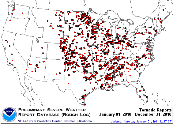
2010 Tornado Occurrences
Source: SPC
According to the Storm Prediction Center (SPC), the final tornado count for the U.S. during 2010 was 1,282. The final 2010 count ranks as the seventh most acive year since records began in 1950. During 2010, seven months experienced above to much–above normal tornado counts — January, April, May, June, July, October, and November.
During 2010, tornadoes were reported in all but four states in the Lower 48 — Delaware, Massachusetts, Rhode Island, and Nevada. Tornadic activity during the year tended to occur in clusters, with the most active regions including the Front Range of the Rockies, the Southeast, the Central and Northern Plains, and the Great Lakes.
Two states in particular had very active tornado years. Arizona had 17 preliminary tornado reports during 2010, tying the state’s annual record, which was set in 1972. The second most tornadoes occurred in 1992 with 13 reports. Eight of the tornadoes occurred on October 6th, marking the most tornadoes to strike in Arizona during a calendar day since records began in 1950. Arizona on average receives four tornadoes annually. The other state with above–normal tornado activity was Minnesota. The state experienced 113 tornadoes during 2010, the most of any state in the country this year, and the most the state has experienced on record. The 2010 tornado count surpassed the previous record which was 74 set in 2001. The annual tornado average for the state is 25. The most active day for the state was June 17th, when 48 tornadoes were confirmed. This bested Minnesota's previous one day tornado count set on June 16, 1992 when 27 tornadoes were confirmed. Minnesota was also the national tornado leader, for the first time on record.
NOAA's National Climatic Data Center is the world's largest active archive of weather data. The preliminary temperature and precipitation rankings are available from the center by calling: 828-271-4800.
NOAA works closely with the academic and science communities on climate-related research projects to increase the understanding of El Niño and improve forecasting techniques. NOAA's Climate Prediction Center monitors, analyzes and predicts climate events ranging from weeks to seasons for the nation. NOAA also operates the network of data buoys and satellites that provide vital information about the ocean waters, and initiates research projects to improve future climate forecasts.