National Overview:
- Temperature Highlights - September
- The average
 September temperature of 66.4°F was 1.0°F above the 20th Century average and ranked as the 32nd warmest based on preliminary data.
 - On a
 regional level, the
 West experienced its warmest September on record. The
 Northwest and
 West North Central experienced their sixth and eleventh warmest such periods.
 -
 Nevada
experienced its warmest September of the 115-year record.
Nevada
experienced its warmest September of the 115-year record.
 California's
average temperature tied with 1984 as the warmest on record. In addition, six other states observed September temperatures among their ten warmest:
California's
average temperature tied with 1984 as the warmest on record. In addition, six other states observed September temperatures among their ten warmest:
 Montana (3rd warmest),
 North Dakota (3rd),
 Idaho (4th),
 Utah (5th),
 Minnesota (6th), and
 Oregon (8th).
 - In the South, a combination a
 slow-moving storm system during the beginning of the month and two surface cold fronts during the last week resulted in much below normal temperature averages in
  Kansas (10th coolest) and
 Oklahoma (11thcoolest).
 - Several divisions in the northern tier states along the Canadian border as well Nevada and Montana averaged record high temperatures during the month. In North Dakota, three contiguous divisions were record warmest in September (Division
 1,
1,
 2, and
 3). Divisions
 1 and
1 and
 2 in Minnesota also experienced record warm temperature averages. Other record warm divisions were in Nevada (Division
 1 and
1 and
 3) and Montana (Division
 2).
2).
- For the
 year-to-date (January–September) period, the contiguous U.S. ranked 29thwarmest.
 New Mexico and
 Arizona recorded their tenth- and eleventh-warmest such periods on record, respectively.
 - Precipitation Highlights - September
- Precipitation was exactly the
 long-term average for the contiguous U.S. as a whole, but
 regional amounts varied widely. The
 South experienced its sixth-wettest September, which was countered by the sixth-driest such period in the
 East North Central region.
 - An
 upper level storm system stalled over the Deep South during the month, bringing copious rains to the region. Statewide-averaged rainfall was among the ten wettest for four southern states (
 Arkansas, 2nd wettest;
  Tennessee (5th),
  Mississippi (6th), and
  Alabama (6th)).
 - Despite record and flood-producing rains in northern Georgia, drier conditions near the coast kept the state's overall average out of the top ten wettest. However, several divisions in the Southeast averaged a record amount of precipitation averages for the month. In Georgia,
 Division 1 averaged 11.39 inches, breaking the old record of 9.56 inches set back in 1957.
 Division 2 averaged 13.07 inches, surpassing the previous record of 12.57 inches recorded just five years prior. In Alabama,
 Division 3 averaged 10.91 inches of precipitation, breaking the previous record of 10.62 inches set in 1906.
  Maine and
 Wisconsin each experienced their fourth driest September and both
 New Hampshire and
 Michigan had their seventh driest such periods.
 - Persistent wetness in
 Arkansas resulted in the state's 10th wettest year-to-date period, while the lack of monsoon moisture this summer helped hold
 Arizona to its fifth driest year-to-date period in 115-years of records.
 - By the end of September, moderate-to-exceptional drought covered 15 percent of the contiguous United States, based on the U.S. Drought Monitor. Drought intensified in the Upper Midwest and eastern Carolinas, while remaining entrenched in much of the West. Drought conditions remained severe in south Texas, despite some improvement.
- About 27 percent of the contiguous United States had moderately-to-extremely wet conditions at the end of September, according to the Palmer Index (a well-known index that measures both drought intensity and wet spell intensity). Additional drought information can be found on the State of the Climate - Drought page.
- Other Items of Note
- Severe weather was limited in September. In the contiguous U.S.; only 10 preliminary tornado reports were recorded by the Storm Prediction Center. Even if all September reports are confirmed, it will represent only 8 percent of the three-year average of 82. With the exception of June, U.S. tornadic activity was well below average to date during 2009.
- During mid-month, a persistent low pressure system in the Deep South and a high pressure system off the eastern seaboard channeled heavy rains into the western Carolinas and the northern half of Georgia. The rains and already-saturated grounds combined to create runoff that overwhelmed many streams and rivers. Major to record flooding occurred across the Atlanta metropolitan area. Eight-day precipitation totals as high as 24 inches were reported in the region.
- During September, 5,535 fires burned approximately 378,523 acres, each of which was below the 2000–2009 average for the month. The acreage lost to wildfire was roughly half of the 2000–2009 average. For the year to date (January–September), 70,217 fires was slightly above the 10-year average, while acreage burned was slightly less than average.
 September
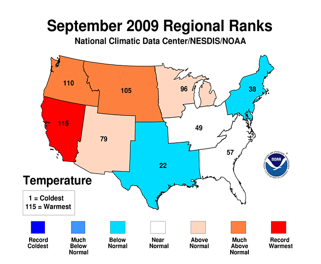 regional level
 West
West Northwest
 West North Central
 Nevada
  California's
 Montana
 North Dakota
 Idaho
Idaho Utah
Utah  Minnesota
 Oregon
 slow-moving storm system during the beginning of the month and two surface cold fronts during the last week
 Kansas
  Oklahoma
 1
1 2
2 3
3 1
1 2
2 1
1 3
3 2
2 year-to-date
 New Mexico
 Arizona
 long-term average
  regional
 South
South East North Central
 upper level storm system
 Arkansas
 Tennessee
 Mississippi
 Alabama
 Division 1
 Division 2
 Division 3
 Maine
Maine Wisconsin
 New Hampshire
 Michigan
  Arkansas
  Arizona
-
 Alaska
had its 27th warmest September since records began in 1918, with a
temperature 1.0°F (0.5°C) above the 1971–2000
average.
Alaska
had its 27th warmest September since records began in 1918, with a
temperature 1.0°F (0.5°C) above the 1971–2000
average.
-
 Alaska
had its 16th warmest July–September on record, with a
temperature 1.0°F (0.5°C) above the 1971–2000
average.
Alaska
had its 16th warmest July–September on record, with a
temperature 1.0°F (0.5°C) above the 1971–2000
average.
-
 Alaska
had its 26th warmest January–September on record, with a
temperature 0.4°F (0.2°C) above the 1971–2000
average.
Alaska
had its 26th warmest January–September on record, with a
temperature 0.4°F (0.2°C) above the 1971–2000
average.
 Alaska
 Alaska
 Alaska
For additional details about recent temperatures and precipitation across the U.S., see the Regional Highlights section below. For information on local temperature and precipitation records during the month, please visit NCDC's Records page. For details and graphics on weather events across the U.S. and the globe please visit NCDC's Global Hazards page.
Regional Highlights:
These regional summaries were provided by the six Regional Climate Centers and reflect conditions in their respective regions. These six regions differ spatially from the nine climatic regions of the National Climatic Data Center.
- Northeast Region: (Information provided by the Northeast Regional Climate Center)
- September 2009 saw a return to below-normal temperatures in the Northeast. The region's average was 60.0°F (15.6°C), which was just 0.2°F (0.1°C) below the 30-year mean. This was 1.9°F (1.1°C) cooler than September 2008 and the coolest September since 2006. West Virginia was the only state to average above normal with a departure of +0.4°F (+0.2°C). Temperature departures among the remaining states ranged from 1.0°F (0.6°C) below normal in Delaware and Rhode Island to 0.1°F (0.1°C) cooler than normal in Maine.
- The first month of autumn was quite dry; in fact, it was the 4th driest September in Maine and the 7th driest in New Hampshire. The region averaged 64 percent of normal rainfall, with departures that ranged from 38 percent of normal in Maine and New Hampshire to 132 percent of normal in Delaware. The three mid-Atlantic states, Delaware, Maryland and New Jersey, were the only states with above normal rainfall. The Northeast average precipitation total of 2.56 inches (6.50 cm) was 1.98 inches (5.03 cm) less than September 2008, but 0.05 inches (0.13 cm) greater than the same month in 2007.
- While most of the Northeast averaged above normal rainfall during the summer months, southwestern Pennsylvania, the panhandle of Maryland, and the northern half of West Virginia did not. As a result, that part of the Northeast was experiencing drought conditions. According to the September 29th US Drought Monitor, the area along the southwestern border of Pennsylvania and northern border of West Virginia, including the Maryland panhandle, was experiencing moderate drought conditions, while abnormally dry conditions are present about 30-40 miles (48-64 km) beyond that area.
- For more information, please go to the Northeast Regional Climate Center Home Page.
- Midwest Region: (Information provided by the Midwest Regional Climate Center)
- Temperatures were near normal across much of the Midwest in September. The coolest temperatures were in Missouri where they ran as much as 2°F (1°C) below normal. The warmest temperatures were in Minnesota, northern Wisconsin, and Upper Michigan. Iowa experienced mild temperatures and avoided both extreme warm and cool temperatures. The statewide high temperature for the month was only 86°F (30°C) which set a new record for the lowest statewide high temperature in September. The coldest temperatures were 32°F (0°C) readings near the end of the month. The range from the coldest to the warmest temperatures was the smallest recorded in Iowa history. Duluth, Minnesota experienced its second warmest September ever, only exceeded by September 1897. The temperatures in Duluth set no records but were consistently above-normal until the last couple days of the month.
- Precipitation varied considerably in September. Percent of normal rainfall varied from less than 25 percent to more than 200 percent across the region. Areas with above-normal precipitation included southern parts of Missouri, Illinois, Indiana, and Ohio as well as all of Kentucky. The remaining parts of the Midwest received below normal rainfall with the driest areas located in northern Wisconsin and parts of northeast Minnesota.
- Drought conditions as of September 29th worsened across the upper Midwest and emerged in Indiana and Ohio relative to the September 1st U.S. Drought Monitor depiction. Precipitation in the northern two-thirds of the Midwest was well below normal until the last 10 days of the month. Despite dry conditions across most of the Midwest, flooding was an issue in the southern parts throughout the month. The Louisville, Kentucky National Weather Service Office had 49 damage reports related to either extremely heavy rain or flooding in September.
- Crops across the Midwest were continuing to mature behind schedule. Corn maturation was four weeks behind schedule in much of Illinois and two weeks behind schedule in Indiana and Missouri. The maturation was pitted against the fall frost. So for areas where the crop was furthest behind had avoided early frost. The upper Midwest has now experienced sub-freezing temperatures with some locations having already experienced temperatures down to 28°F (-2°C).
- Severe weather was limited in September. Iowa experienced no severe weather during the month of September for the first time since 1976. The region only experienced sporadic, localized severe weather except for the 27th when a strong cold front pushed across the region. The severe weather that day reached from Wisconsin to Ohio. September's only Midwest tornado was an EF1 storm that hit just north of Borden, Indiana on the 20th.
- For details on the weather and climate events of the Midwest during May, see the weekly summaries in the MRCC Midwest Climate Watch page.
- Southeast Region: (Information provided by the Southeast Regional Climate Center)
- Mean temperatures for September 2009 were above normal across much of the southern and western portions of the region. Temperatures were more than a 1°F above normal across most of FL, AL, and western GA as well as small portions of SC, VA, and western NC. Mean temperatures were slightly below normal across much of NC, portions of VA, and small areas across the remainder of the region. For the 2nd straight month, San Juan, PR registered a mean temperature of 84°F (29°C), which was 2°F above normal. This was the 5th warmest September in a record extending back 59 years and is only 0.7°F shy of the all time record, which was set in 1995. Interestingly the warmest temperatures of the month in many areas did not occur until the last week of the month. Both Danville, VA and Raleigh, NC recorded a maximum temperatures of 91°F (33°C) on the 26th, and Camden, SC, which is situated 20 miles east Columbia, registered a maximum temperature of 96°F (36°C) on the prior day. There were only 31 daily maximum records broken during the month. The summerlike heat during the last week of the month was followed by the rapid passage of a cold front that ushered in the first wave of autumnal air. This modified polar air was associated with daily minimums of 48°F (9°C) and 40°F (4°C) at Tallahassee, FL and Dallas, GA , respectively, on the 30th. Due to the lack of strong cold air outbreaks, there were only 13 daily minimum temperature records broken during the month.
- Broad portions of AL, northern GA and western NC recorded much above normal precipitation totals during the month of September in contrast with the remainder of the region, which was relatively dry. Numerous locations in northern GA registered the wettest September on record, including Atlanta Peachtree airport, which recorded 15.89 inches (404 mm) of precipitation. This was nearly 4 inches (102 mm) greater than the totals observed in 2004, the 2nd wettest September on record. The heaviest precipitation in the state occurred in Canton, GA, which recorded slightly over 20 inches (508 mm) of precipitation for the month. Most of the precipitation occurred between the 15th and 22nd of the month, as a deep southerly flow associated with a quasi-stationary upper level system to the west persistently advected moisture across the region. Canton and Atlanta-Peachtree airport received over 17 inches (432 mm) and 14 inches (356 mm) of precipitation, respectively, during this week. According to the U.S. Geological Survey, the rainfall produced what was estimated as the 500-year flood in areas around Atlanta. Ten people were killed in the flooding, most by driving onto roads covered by moving flood waters. This pattern of excessive precipitation also extended into AL and western NC. Lake Toxaway, NC and Aliceville, AL received over 24 inches (610 mm) and 17 inches (432 mm) of precipitation for the month, which was more than 17 inches(432 mm) and 13 inches (330 mm) above normal. In polar contrast, portions of southern GA, eastern SC, and central NC received less than 25 pecentof the normal precipitation for the month. Most notably, Lumberton, NC and Charleston, SC recorded only 0.33 inches (8 mm) and 0.48 inches (12 mm) of precipitation, respectively, for the month.
- Heavy precipitation during the month ended the moderate drought (D1) conditions across northwestern SC; however, D1 conditions persisted across a small portion of central NC. Severe drought (D2) conditions developed rapidly across southern NC and eastern SC in response to the marked lack of precipitation across these areas. Moderate and extreme drought coverage expanded from 2.4 pecent to 7.4 pecent across the Southeast during the month. This, however, is much lower than the spatial coverage experienced this time last year when moderate (D1) drought and greater covered over 40 pecent of the region. The dry conditions in NC have had little impact on agriculture; in fact, the dry fields aided some growers in the harvesting of crops. Only one tornado was reported in the region during the month and it caused only minor damage to a few building structures in Lomax, AL. Although September is the peak of the tropical cyclone season, there was no activity anywhere along the Southeast Coast during the month. Tropical Cyclone Erika did bring some heavy rainfall to Puerto Rico and the Virgin Islands on the 4th and 5th of the month.
- For more information, please go to the Southeast Regional Climate Center Home Page.
- High Plains Region: (Information provided by the High Plains Regional Climate Center)
- Temperature departures varied widely this September as average temperatures generally ranged from 8°F (4.4°C) below normal in the southern portions of the region to 10°F (5.5°C) above normal in the northern portions of the region. The warm temperatures in the north helped farmers in their harvesting efforts. According to USDA, the warm temperatures in the north aided small grain harvest and also helped the maturity of late season crops. Many locations in North Dakota had average temperatures which ranked in the top 10 warmest Septembers on record. The warm temperatures broke two longstanding records, one of which had been in place in Grand Forks, North Dakota since 1906. The average temperature this month for Grand Forks was 64.2°F (17.9°C) which broke the old record of 62.8°F (17.1°C). Williston, North Dakota also had its warmest September on record. The old record of 64.0°F (17.8°C) was just barely edged out by the new record of 64.3°F (17.9°C).
- September 2009 was drier than normal for most of the region as precipitation departures of 1.50 inches (38.10 mm) below normal were common. Areas of the Region that received more than 200 percent of normal were isolated to a swath of Kansas and pockets of North Dakota, South Dakota, and Colorado. The rain that fell in North Dakota helped alleviate drought conditions in the east central portion of the state as moderate drought conditions have been downgraded to abnormally dry conditions.
- This month's wet spot was Oakley 4 W, Kansas which received 7.81 inches (198.37 mm) of precipitation. This record breaking amount was 6.47 inches (164.34 mm) above normal, or 583 percent of normal. The old record of 6.20 inches (157.48 mm) was recorded in 1976. On September 8th, 4.81 inches (122.17 mm) fell breaking the previous record of 2.83 inches (71.88 mm), which occurred in 1935. This rainfall was part of a heavy rain event that occurred in western Kansas and eastern Colorado on the 7th and 8th of September. The heavy rains in the area resulted in rises on creeks and streams and, according to the National Weather Service in Goodland, Kansas several homes were inundated along the south fork of the Saline River, just north of Oakley.
- Despite lower-than-normal precipitation in many locations, much of the Region remained drought free this September. Moderate rains in the middle of the month allowed for the elimination of moderate drought conditions (D1) in east central North Dakota. Abnormally dry conditions (D0) were present in a small portion of south central Nebraska, eastern South Dakota, and east central and western North Dakota. However, in southwest Colorado, the Animas and Los Pinos Rivers were flowing below normal and the Lemon Reservoir was 25 percent full, which places that area into D1. According to the U.S. Seasonal Drought Outlook released September 17th, the drought conditions in east central North Dakota were expected to improve through December 2009.
- For more information, please go to the High Plains Regional Climate Center Home Page.
- Southern Region: (Information provided by the Southern Regional Climate Center)
- September mean daily temperatures for the Southern Region were generally near normal to below normal in the west, and near normal to slightly below normal to the east. Specifically, mean daily temperatures averaged 0-2°F (0-1°C) above-normal in Tennessee, Mississippi, the eastern Arkansas border and in eastern Louisiana. This is a slight change from last month, where temperatures in the eastern half of the Southern Region were generally near normal to below normal. Conversely, the western half of the Southern Region, which observed warmer than normal temperatures last month, experienced a cooler than normal September. Most stations in the western half of the southern region averaged only 0-2°F (0-1°C) below normal. The coolest areas of the Southern Region occurred in central and eastern Oklahoma and in central Texas, where stations averaged between 2-4°F (1-2°C) below the monthly normal.
- September was a very wet month for most of the Southern Region. In Arkansas, most stations reported more than twice the monthly normal, with some stations in the southern part of the state reporting over three times the monthly normal. In the south central climate division, for example, the station Calion L&D reported 13.63 (336.2 mm) inches of rainfall, or 10.47 inches (266 mm) above the normal. This was the wettest September on record for that station, which began keeping records in 1941. In the southwest climate division, the station Pine Ridge reported 16.26 inches (413 mm) of rainfall, which was 11.69 (296.9 mm) above the normal and also the wettest September on record (1925-2009). September was also quite wet in Mississippi, Tennessee, central Texas, northern Louisiana and eastern Oklahoma. In Mississippi, most stations in the northern half of the state reported between 200-300 percent of normal. Many farmers in the northeast of Mississippi had to delay the harvest of soybeans and corn because heavy rainfalls made the ground too water-logged to run their tractors. In the southern half of the state values ranged mainly from 150-200 percent of the monthly allotment. Similar values were observed in Tennessee except in the northwest where it was slightly drier than normal. In central and southern Texas, rainfall totals for the month ranged from 200 to over 300 percent of normal. This rainfall proved to be very helpful in alleviating drought conditions, which have persisted for several months. The high rainfall totals did not contribute much to raising stream and reservoir levels, which is a testament to just how dry it has been there this year. Putting the dryness into perspective, Corpus Christi International Airport received a total of approximately 5 inches (127 mm) of precipitation from January 1, 2009 to September 1, 2009; almost the exact amount that was received at the airport in September alone. In fact, many stations in the Texas drought areas received more precipitation in September than they had during the previous eight months combined.
- The driest areas of the Southern Region included north central Oklahoma and much of western Texas, with the exception of El Paso and Hudspeth Counties. Precipitation totals for the month in those areas ranged from approximately 25 to 75 percent of normal. It was also drier than normal in southeastern Texas and south western Louisiana, where stations reported between 40 and 90 percent of normal precipitation for the month.
- Much needed rainfall in southern Texas allowed for some improvements in drought conditions that have persisted for several months. As of September 1, 2009, approximately a quarter of the state of Texas was experiencing D3 (extreme) or D4 (exceptional) drought. Because of the anomalous September rainfall, that value has been reduced to only approximately 12 percent. It is worthy to note, however; that approximately one fifth of the state remains in D2 (severe drought) or worse. It is also worthy to note that much of the initial rainfall that occurred in early to mid-September did not result in a lot of runoff. Most of the rainfall that was received went directly to recharging the soils. One other area of improvement was in southeastern Louisiana and southwestern Mississippi, where heavy rains have eradicated moderate drought conditions; although much of the area is still designated as anomalously dry (D0).
- For more information, please go to the Southern Regional Climate Center Home Page.
- Western Region: (Information provided by the Western Regional Climate Center)
- Temperatures were above normal for the entire West except for New Mexico and portions of Colorado. The greatest positive departures were in the northern plains and northern Rockies with numerous locations in Montana, Idaho, and Wyoming reporting record and near-record September temperatures. In some cases the old records were broken by a significant margin, and in many places September was warmer than an average August. Billings and Bozeman, Montana, had their warmest September on record while Helena had its 3rd warmest dating back to 1893. In this area average monthly maximum temperature departures were much higher than minimum temperature departures. Boise, Idaho, recorded their 2nd warmest September on record, and Salt Lake City its 3rd warmest.
- Precipitation was generally below normal throughout the region except for portions of the Pacific Northwest and parts of Arizona, New Mexico and Colorado. A rather strong surge of monsoonal moisture moved into the southwest during the first week of the month producing locally heavy rain in some areas. Yuma, Arizona, received 1.62 inches of rain on the 5th, most of it falling in one hour. This was twice as much as the entire 2009 rainfall total of 0.76 inches up to that date.
- The Station Fire in the Angeles National Forest that began on August 26th was 98 percent contained by Sep 28th. Total area burned was nearly 161,000 acres, making it the largest fire in modern history for Los Angeles County and the 10th largest fire in California since 1933. The cause has been determined as arson. A total of 89 residences, 26 commercial structures and 94 outbuildings were destroyed. Two firefighters lost their lives and 11 people were injured. The Angeles Crest Highway (Hwy 2) was still closed to traffic. Total cost of fighting the fire is at around $83.1 million.
- For more information, please go to the Western Regional Climate Center Home Page.
See NCDC's Monthly Extremes web-page for weather and climate records for the month of May. For additional national, regional, and statewide data and graphics from 1895-present, for May, the last 3 months or other periods, please visit the Climate at a Glance page.
PLEASE NOTE: All of the temperature and precipitation ranks and values are based on preliminary data. The ranks will change when the final data are processed, but will not be replaced on these pages. Graphics based on final data are provided on the Climate Monitoring Products page and the Climate at a Glance page as they become available.