Northeast Region:
(Information provided by the Northeast
Regional Climate Center)
- Northeast temperatures averaged above normal in March, but
there were a few areas where temperatures were cooler than normal.
Most of Maine and the coastal regions of the Northeast saw
temperatures that averaged from 1 to 3 degrees F (0.6 to
1.7°C) below normal. Temperatures were about 1°F
(0.6°C) above normal Inland, increasing to 2-3 degrees F (1 to
1.7°C) above normal in southwestern Pennsylvania and West
Virginia.
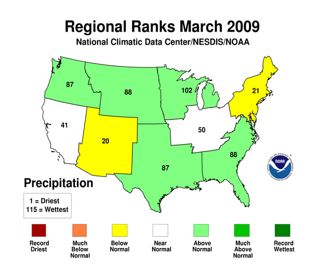
- On average, the Northeast received below normal precipitation
in March. Central and western New York and northeast Pennsylvania
were the only regions with above normal precipitation. Totals in
these areas were 110 to 200% of normal. Central and southern
Pennsylvania, most of New Jersey and portions of Maryland were the
driest in the Northeast, with only 25 to 50% of their normal March
precipitation totals.
- Drought conditions expanded to the north during March. The US
Drought Monitor issued March 31, 2009 indicated that the southern
half of Pennsylvania and all of New Jersey and Delaware were
abnormally dry. In West Virginia, most of the state was
experiencing abnormally dry conditions. The exceptions were
portions of the Central, Southern and Northeastern Climate
Divisions, which were in the moderate drought category. Moderate
drought conditions were also found in most of central Maryland,
with abnormally dry conditions in the rest of the state.
- A Nor'easter blasted through the region on the 1st and 2nd,
dumping 6 to 12 inches (15-30 cm) of snow in a swath from Maryland
to Maine. Windy conditions combined with the heavy snowfall to
disrupt travel, down power lines, close the New York City schools
for the first time since 2004, and further deplete town, city and
state snow removal budgets, especially in New England. According to
the March 3 issue of the Boston Globe, several towns in
Massachusetts spent 3-4 times their 2009 snow removal budget, while
at the state level, snow removal costs were $96.5 million over
budget so far this winter. Boston's snow total for the winter
season thus far is 25.3 inches (64.3 cm) above the 1971-2000
normal. The 65.9 inch (167.4 cm) total made this season the 7th
snowiest in Boston since 1935.
For more information, please go to the Northeast
Regional Climate Center Home Page.
Midwest Region:
(Information provided by the Midwest
Regional Climate Center)
- March temperatures were 2°F to 4°F (1°C to
2°C) above normal in southeastern Missouri, southern and
central Illinois, Indiana, and most of Ohio. In northwest
Minnesota, temperatures were 2°F to 6°F (1°C to
3°C) colder than normal. Average temperatures were within
2°F (1°C) of normal across the rest of the region.
Although the average temperatures were near normal for much of the
region, there were big swings in temperature throughout the month.
Record cold temperatures on the first couple days of March,
10-20°F (5-10 C) below normal on the 2nd, gave way to record
warmth, up to 25°F (14°C) above normal on the 6th, within
the week. All nine states had a station set a record low
temperature during the first four days of the month. Record high
temperatures were set on March 5-10 in every state except
Minnesota, which set record highs later in the month. The
temperature swings continued with the whole region shifting back
and forth between cold and warm several times. Examples of the
temperature swings are Jackson, Kentucky and International Falls,
Minnesota. Jackson set a record low of 13°F (-11°C) on
March 2 and a record high of 77°F (25°C) on March 10.
International Falls topped that with a swing from a record low of
-28°F (-33°C) on March 12 to a record high of 53°F
(12°C) just two days later on March 14.
- 2.5 to 4 inches (64-102 mm) of precipitation fell in northern
and central Minnesota, providing two to four times the normal
precipitation for the month. Another swath of above-normal
precipitation extended from northwest Missouri and southeast Iowa
to southern Michigan and northern Ohio. Records for March monthly
precipitation were set at Peoria, Illinois (7.49 inches (190 mm)),
Madison, Wisconsin (6.19 inches (157 mm)), Fargo North Dakota (4.62
inches (117 mm)), and International Falls, Minnesota (3.75 inches
(95 mm)). New March snowfall records were also set at Fargo, 28.1
inches (714 cm), and International Falls, 30.1 inches (765 cm). In
Iowa, the statewide average of snow was 1.4 inches (3.6 cm), making
this the least snowy March since 1997 and ranks 15th least snow for
the month among 122 years of records. Less than normal
precipitation fell from southeast Missouri to the southern two
thirds of Ohio and also from northwest Iowa to northern Michigan.
Drought conditions continued in southeast Minnesota, northern
Wisconsin, and the Upper Peninsula of Michigan while abnormally dry
conditions emerged in southern Ohio.
- Red River flooding set a new record crest of 40.82 feet at
Fargo, North Dakota. Major flooding also occurred up and down
stream on the Red River and on its tributaries. Neighborhoods and
businesses were evacuated in Fargo and across the river in
Moorhead, Minnesota. Sandbagging to increase the height of the
levees in Fargo and Moorhead was largely successful, thus avoiding
more extensive damage. Two winter storms swept across Minnesota in
March bringing double digit snow falls on March 9-11 and March
30-April 1. The Lake Superior shoreline from Duluth northward was
hit by freezing rain on March 23-24. Ice accumulations in excess of
an inch (25 mm) were wide spread leading to tree damage and power
outages. The southern part of the region experienced severe weather
during the month. Tornadoes occurred on March 8 in Missouri,
Illinois, Indiana, and Ohio. Iowa was hit by five tornadoes on
March 23.
For details on the weather and climate events of the Midwest during
March, see the weekly summaries in the
MRCC Midwest Climate Watch page.
Southeast Region:
(Information provided by the Southeast Regional
Climate Center)
- Mean temperatures for March 2009 were close to normal across
most of the region. Temperatures were slightly below normal across
southeastern Virgina, much of North Carolina and South Carolina as
well as portions of Georgia and Florida. Temperatures were slightly
above normal across Alabama, much of Florida, and small portions of
the Carolinas and Virginia. In Puerto Rico, temperatures were
slightly below normal. There was much variability in temperatures
during the month as is commonly the case in March. The coldest
temperatures were observed during the first couple of days of the
month as a modified arctic mass settled behind a strong system that
dropped snowfall across portions of the region. Several locations
in Virgina and North Carolina recorded all time record low
temperatures for the month. Richmond, Virgina, for example,
registered a minimum temperature of 10°F (12°C) on both
the 3rd and 4th of the month breaking the all-time March record
minimum of 11°F (31°C) set in 1943. Tallahassee, Florida
dropped to 26°F (-3°C) on the 4th. This was sixth time in
which sub-freezing air settled across northern Florida since the
beginning of the winter. A rapid warm up ensued across much of the
region after the cold snap. Daily maximum temperatures soared into
the 80's across much of the region on various days between the 8th
and 12th of the month. Columbia, South Carolina and Jacksonville,
North Carolina recorded a maximum temperature of 88°F
(31°C) during this period.
- Precipitation totals for March were quite variable across the
region. Precipitation was less than 50% of normal across much of
central and southern Florida, portions of South Carolina,
southeastern North Carolina and northern Virginia. Naples, Florida
recorded only 0.28 inches (7 mm) of precipitation for the month,
making it the 13th driest February in a record extending back 64
years. Tifton, Georgia and Washington, DC received 1.47 inches (37
mm) and 1.97 inches (50 mm), which was 29% and 55% of the normals,
respectively for the month. Most of Puerto Rico experienced above
normal precipitation totals for the month. Juncos in the eastern
interior of PR recorded 9.01 inches (228 mm) of rain, which was
more than 6 inches above normal. A broad region of above normal
precipitation totals was observed across the southern half of
Alabama and much of Georgia; smaller portions of northeastern North
Carolina and southeastern and southwestern Virginia as well as
southeastern and northern Florida also recorded above normal
precipitation totals for the month. Crestview, in the western
panhandle of Florida, received 14.86 inches (377 mm) of
precipitation for the month, which was 7.68 inches (195 mm) above
normal. Heavy rainfalls between the 26th and 28th of the month
contributed substantially to the monthly totals across western
northern Florida and southern Georgia. Crestview, Florida and
Albany, Georgia recorded 9.57 inches (243 mm) and 6.03 inches (153
mm) of rainfall, respectively, during this 3-day period. Heavy
precipitation was also observed on the first day of the month
across much of Georgia and portions of the Carolinas. This
precipitation was connected with a complex weather system that had
already produced much rainfall across Alabama and Georgia during
the last days of February. The rainfall turned over to heavy
snowfall on the western edges of the storm resulting in substantial
accumulations in regions that typically see very little snow.
Columbus, Georgia and Anderson, South Carolina reported 6.5 inches
(165 mm) and 5.0 inches (127 mm) of snow, respectively. The heavy
wet snow combined with strong winds and wet soils to down trees and
cause power outages across portions of northern Georgia and
northwestern South Carolina. The system traveled northeastward
producing a broad swath of heavy snow across the western half of
North Carolina and Virginia. Shelby North Carolina and Lynchburg,
Virginia both reported snowfall totals of nearly 10 inches (254
mm).
- The extreme drought (D3) conditions persisting across extreme
northeast Georgia and northwest South Carolina was reduced to
severe drought (D2) as a result of three significant precipitation
events during the month. This marked the first time in two years in
which the entire southeastern region was free of extreme (D3) and
exceptional (D4) drought. Severe drought (D2) conditions persisted
across portions of central and southern Florida. Moderate drought
conditions continued across northern Virginia, western North
Carolina, eastern Georgia, and portions of Florida. Several
clusters of severe thunderstorms were observed between the 26th and
28th of the month. Several tornadoes were reported across Florida
on the 26th and 27th, eastern North Carolina on the 27th and South
Carolina, Georgia, and Alabama on the 28th.
For more information, please go to the Southeast Regional
Climate Center Home Page.
High Plains Region:
(Information provided by the High Plains
Regional Climate Center)
- In March the majority of the High Plains region was near normal
with the monthly average temperature departures ranging from
2°F (1.1°C) below normal to 2°F (1.1°C) above
normal. Warmer pockets of the region were in western, central, and
southern Colorado, southern Wyoming, and western Kansas where
monthly temperature departures ranged from 2°F to 6°F
(1.1°C to 3.3°C) above normal. North Dakota and northern
South Dakota were the cold areas in the region with average
temperatures that were well below normal. Most of North Dakota
recorded average temperatures that ranged from 4°F to
10°F (2.2°C to 5.5°C) below normal, however this
cold weather was not record breaking.
- The big story this month was in eastern North Dakota, where
record precipitation coupled with warm temperatures led to record
breaking flooding along the Red River. On March 28, the Red River
at Fargo crested at 40.82 feet. This breaks the old record of 40.1
feet recorded April 7, 1897. Contributing to the flooding is the
record precipitation that occurred across eastern North Dakota.
Fargo, ND is this month's "extreme" location which recorded both
the wettest and snowiest March on record. The Hector International
Airport in Fargo received 4.62 inches (117.35 mm) of liquid
equivalent precipitation, or 395% of normal precipitation. This
shattered the previous record of 2.83 inches (71.88 mm) recorded in
1882. A record snowfall of 28.1 inches (71.37 cm) fell at the Fargo
Hector International Airport which broke the old record of 26.2
inches (66.55 cm) set in 1997.
- March 2009 was an active month with several intense low
pressure systems crossing the region. Interesting events include
record flooding on the Red River in North Dakota, tornadoes in
eastern Nebraska, and numerous blizzards which affected each state
in the region. Major flooding occurred along the Red River in North
Dakota. Factors leading to this event include record breaking
precipitation and snowfall. The record setting stage at Fargo was
40.82 feet and occurred March 28 (at the Fargo location, any stage
above 18 feet is considered flood stage for the Red River). The
previous record was 40.1 feet which was set April 7, 1897. In more
recent times, the second highest crest occurred in 1997 at 39.57
feet. Many residents were evacuated from the area and schools,
universities, and businesses closed to help out with the
sandbagging effort. A cold air intrusion slowed the flooding at the
end of the month, however, a secondary crest is expected to occur
in April and current forecasts indicate that this crest may top the
newly set record.
- A fast moving supercell produced five tornadoes in eastern
Nebraska on March 23. Two EF1 tornadoes and one EF2 tornado were
confirmed in Lancaster County. Two additional EF1 tornadoes were
confirmed in Cass County. Eight injuries were reported and
preliminary damage estimates for the tornadoes is less than
$100,000.
- A late March blizzard dumped one to two feet of snow across
Colorado and Kansas. Strong winds and heavy snow combined to create
blizzard conditions in some areas March 27-28. This blizzard set
the 6th greatest 24-hour snowfall total for Dodge City, Kansas,
with 12.5 inches (31.75 cm). In addition to the heavy snow, some
portions of southeastern Kansas had significant ice accumulations.
Power outages were widespread.
For more information, please go to the High Plains
Regional Climate Center Home Page.
Southern Region:
(Information provided by the Southern
Regional Climate Center)
- With the exception of the central portions, mean temperatures
in the Southern Region were generally above normal during the month
of March. The warmest areas in the region were observed in western
and northwestern Texas, where mean temperatures averaged 3-6°
F (1.5-3 ° C) above the monthly normal. Similar values were
also observed in central and southern Oklahoma and in southeastern
Louisiana. In the central area of the southern region, mean monthly
temperatures were only slightly (0-2° F (0-1 °C)) below
normal for the month, while elsewhere, mean temperatures averaged
only a couple (1 °C) degrees above normal.
- In contrast to the past two months, much of the southern half
of the Southern Region experienced near to above normal
precipitation totals. Many counties in Central Texas, for example,
received between two and four times the monthly allotment. Similar
values were also observed in southern Mississippi, however; much of
that rainfall was received in the final week of the month. During
that week, much of southern Mississippi received over 5 inches (127
mm) of rainfall over approximately 4 to 5 rain days. In fact,
stations in the coastal areas of the state received as much as 9-10
inches (229 mm-254 mm) of rainfall. Throughout much of southern
Arkansas and northern Mississippi, precipitation totals for the
month were within the normal range. This was also the case in
northeastern Oklahoma. By contrast, northern and southern Texas
observed precipitation totals that fell well below the normal
range. In the northern Texas panhandle, most stations only reported
approximately 25 to 50% of normal precipitation. It was slightly
drier in the southernmost regions of the state, with many stations
reporting only 5 to 50% of normal rainfall. Similar totals were
also observed in the northern counties of the western Texas
panhandle, and in the south central counties of Oklahoma. In
Tennessee, precipitation totals were generally within the normal
range, except for in the eastern counties, and in the north central
part of the state, where most stations reported between 50 to 75%
of normal precipitation.
- The spatially variable pattern of March precipitation has had
both a positive and negative impact on drought conditions within
the Southern Region. Steady and above normal precipitation in
Louisiana and southern Mississippi has helped to eradicate the
moderate drought and abnormally dry conditions that existed there
last month. Similarly, near normal precipitation in south central
Tennessee has led to the removal of abnormally dry conditions
there. In Oklahoma, dry conditions in the western counties resulted
in a one category deterioration from moderate to severe drought. In
addition, the two panhandles of Texas also observed a one category
deterioration to moderate drought conditions. This was also the
case in the southernmost counties of the state, where precipitation
totals were well below normal for the month. Although many portions
of central Texas observed above normal rainfall during March, it
was not sufficient to provide much improvement to the drought
conditions that have persisted there for approximately one
year.
- As the climate in the Southern Region shifts into spring,
severe weather events were enhanced during the month of March. Many
of the severe weather reports consisted of the typical spring
events that are commonly associated with southern climate.
Specifically, there were dozens of wind and small hail reports,
along with twisters that touched down briefly in Texas, Louisiana,
Mississippi and Tennessee. On the 25th of the month, an EF1 rated
tornado touched down in Meridian, MS, clocking winds in the 90-95
mph range. Major damage but no injuries were reported. According to
the Mississippi Emergency Management Agency, the tornado destroyed
a few homes and damaged many others. On the same day, in Loyal
Valley, TX, golf ball to baseball-sized hail stones were reported.
The following day, more twisters ripped through Mississippi. Near
Magee, MS, a tornado caused major damage with injuries. The
National Weather Service confirmed that this was an EF3 rated
tornado. In total, three tornadoes touched down in Madison County,
with the other two being EF1 and EF0 rated. Several homes were
damaged and the Governor declared a state of emergency for 9
counties in the state. According to WDSU News, a total of 60 homes
were damaged in the storms and at least 20 people were injured. In
Baton Rouge, straight line winds on the 26th damaged many portions
of the Louisiana State University campus. For instance, damage was
reported at the newly opened Alex Box baseball facility and the
newly opened Tiger Park softball facility. The soccer complex
suffered the most damage, with bleachers being tossed onto the
soccer pitch. Several building on campus sustained some minor
damage and approximately 50 vehicles were damaged by falling limbs
and heavy winds that carried debris.
For more information, please go to the Southern
Regional Climate Center Home Page.
Western Region:
(Information provided by the Western
Regional Climate Center)
- Temperatures were mostly below normal in the northern half of
the West and above normal in the southern half. California was a
mixed bag. Parts of the Pacific Northwest and eastern Montana were
5-6°F (3-4 deg°C) below normal for the month. Seattle
recorded their coolest March in 33 years, and 15th cooler than
normal month out of the last 19 months. Up through 2007 March had
been showing a significant warming trend in most of the West. In
Hawaii, Hilo recorded their coolest March ever while Lihue had
their lowest average maximum temperature ever for March.
- Except for northern Idaho, western Montana and portions of
Wyoming, most of the West had a drier than normal March. Although a
strong storm hit California during the first 4 days of the month
producing heavy rain and snow, most locations had monthly totals
well below average. An important exception was the northern Sierra,
which saw precipitation and snowfall totals of up to 115% of
normal, increasing the snowpack from 70% of normal at the beginning
of the month to 80% by the end of the month. The Eight-Station
Index used for tracking input to the California State Water Project
ended the month at 8.2 inches (208 mm), 119 percent of average.
Except for the Southwest, the rest of the West is near or slightly
above normal on the April 1st snow surveys. Although the southwest
was extremely dry, Albuquerque measured 0.24 inches (6.1 mm) on the
9th, breaking a 72-day string of no-precipitation days, their 8th
longest such spell. Seattle continued with their unusually snowy
winter and up until March 26th had measured more snowfall for the
winter season (20.3 inches; 51.3 cm) than Denver's 19.1 inches
(49.0 cm). Nome, AK, recorded their snowiest March on record, which
followed their snowiest February on record. This led to the second
greatest snow depth ever recorded, 78 inches (198.1 cm)on the
12th.
- During the first 4 days of the month, heavy rain and snow in
California. One of the more powerful storms of the winter hit
California during the first 4 days of March. Heavy rain and
localized flooding occurred in the northern half of the state with
one location north of Redding measuring over 10 inches (254 mm) of
rain in two days. Up to six feet of snow fell in higher elevations
of the Sierra near Lake Tahoe. This storm closed Interstate 80 over
the Sierra for 76 miles for a time on the evening of the third.
- On March 16 local flood in Redding, California. Up to 4 inches
of rain fell in 4 hours in very localized areas near Redding
causing one fatality and numerous accidents.
- March 26 brought heavy snow along Front Range of Colorado. Up
to 15 inches (150 cm) of snow along Colorado's Front Range
cancelled hundreds of flights at Denver International Airport and
caused a 40 car pile-up on Interstate 25 near the Colorado/Wyoming
border.
For more information, please go to the Western
Regional Climate Center Home Page.
|