National Overview:
- Temperature Highlights - December
- The
 December 2009 temperature for the contiguous United States was 30.2 degrees F, which is 3.2 degrees F below the long-term average. For the
  year 2009, the contiguous U.S. averaged 53.1 degrees F, which was 0.3 degrees warmer than the long-term average.
 - For December, the nationally-averaged temperature was below normal as several punches of Arctic air dove deep into the
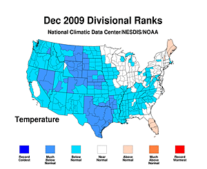 United States. December temperatures in the
  West North Central region were the eighth coolest on record and the
  South region experienced their ninth coolest December.
 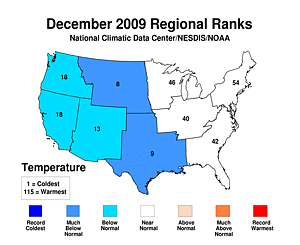 Below-normal temperatures expanded westward into the
  Northwest,
  West, and
  Southwest. Of the nine climate regions across the contiguous U.S., none averaged warmer than normal temperatures.
 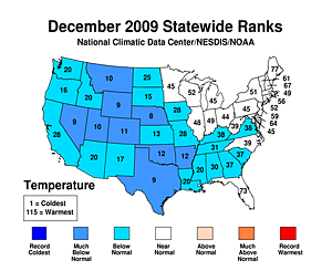 Statewide temperatures coincided with the regional values as nine states recorded much-below normal temperatures. Nebraska had its eighth coolest December, Texas, Nevada, and Wyoming their ninth, and Montana and Utah their tenth coolest.
 - The second half of 2009
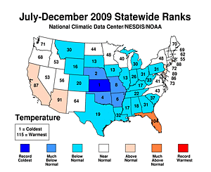 (July-December) was the coolest on record for Kansas, second coolest for Nebraska, fourth coolest for Oklahoma, sixth coolest for Arkansas, and eighth coolest for Missouri. Florida's temperature for the same period was much-above normal.
 - For 2009, the contiguous U.S. temperature ranked 35th warmest. Temperatures were above normal in parts of the South, Southwest and West, while much of the Central Plains and Midwest were below normal.
- Based on NOAA's Residential Energy Demand Temperature Index (REDTI), the contiguous U.S. temperature-related energy demand was 4.9 percent above average for December. The REDTI was 1.3 percent below average for 2009 as a whole.
- Precipitation Highlights - December
 December precipitation, averaged across the contiguous United States, was 2.88 inches, 0.65 inch above the 1901-2000 average, and ranked as the 11th wettest December on record. The U.S. averaged 31.47 inches of
  precipitation for the year, which was 2.33 inches above the long-term average.
 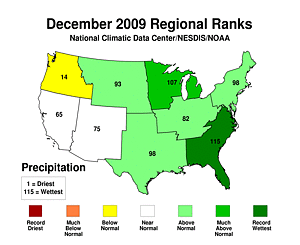 Regionally, the Southeast experienced its wettest December on record. Within this region, Virginia, South Carolina, and Georgia also had their record wettest December, as did Maryland in the Northeast climate region. A total of
 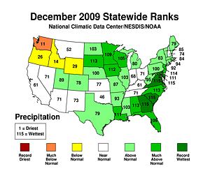 13 states experienced December precipitation that ranked among that their ten wettest. Only Wyoming, Idaho, Oregon, and Washington had precipitation below December's long-term average.
- For the last quarter of 2009
 (October-December), the Nation as a whole experienced its fourth wettest such period. Four of the nine
 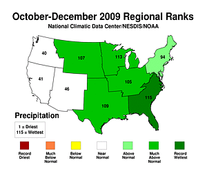 U.S. climate regions (Southeast, East North Central, South, and West North Central) had top-ten-wettest periods. The
  Southeast's final quarter was its wettest on record. Four states had record October-December periods:
 Delaware,
  Maryland,
  Virginia, and
  South Carolina. In all,
 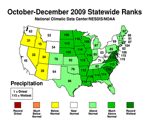 19 states experienced a top-ten-wettest such period.
 - During the last half of 2009
 (July-December), the nationally-averaged precipitation was fifth wettest all-time. On a
 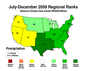 regional scale, the
  South was record wet, the Southeast had its fifth wettest period, and the Central had its eighth wettest.
 Arkansas,
  Louisiana,
  Alabama, and
  Delaware each had their wettest such period on record. In contrast,
 Arizona saw its fourth driest July-December on record.
 - Arkansas' remarkable run of wetness during 2009 resulted in a statewide average precipitation of
 70.52 inches, its second wettest year on record. The state saw four months during 2009 with top three precipitation values (May, July, September, and October).
  Illinois and
  Alabama also experienced their second wettest year. Persistent dryness led
 Arizona to its fourth driest year on record.
 - Other Items of Note
- Several significant winter storms affected the U.S. during the month. A NOAA-supported Rutgers University analysis of NOAA satellite observations indicated average snow extent for the contiguous U.S. was over 4.1 million square km - the largest for any December since the satellite record began in 1966. Several major cities, including Philadelphia, Washington, and Oklahoma City, had their snowiest Decembers on record.
- By December's end, moderate-to-exceptional drought covered only 12.4 percent of the contiguous United States, based on the U.S. Drought Monitor. During the year, major drought episodes in California and South Texas improved significantly, while drought conditions emerged across much of Arizona, partly due to the weakness of this year's North American monsoon.
- About 43 percent of the contiguous United States had moderately-to-extremely wet conditions at the end of December, according to the Palmer Index (a well-known index that measures both drought intensity and wet spell intensity). This footprint is significantly larger than the long-term average.
 December
  year
year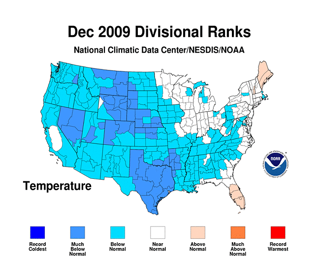 United States
 West North Central region
 South region
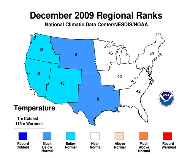 Below-normal temperatures
 Northwest
 West
West Southwest
 Statewide temperatures
 (July-December)
 December precipitation
 precipitation for the year
 Regionally
 13 states
 (October-December)
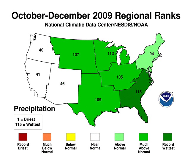 U.S. climate regions
 Southeast's
 Delaware,
 Maryland,
 Virginia,
 South Carolina
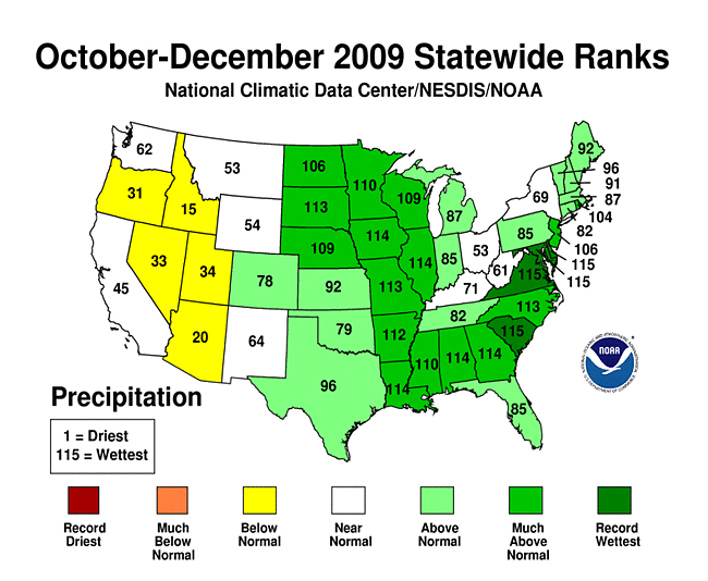 19 states
 (July-December)
 regional scale
 South
South Arkansas
 Louisiana
 Alabama
 Delaware
 Arizona
 70.52 inches
 Illinois
 Alabama
 Arizona
Beginning with January 2010 processing, the Alaska temperature and precipitation report will comprise of several datasets at NCDC, integrating GHCN and COOP datasets. The data below is the last processing completed with just GHCN ver2 adjusted data.
-
 Alaska
had its 17th warmest December since records began in 1918, with a
temperature 4.5°F (2.5°C) above the 1971–2000
average.
Alaska
had its 17th warmest December since records began in 1918, with a
temperature 4.5°F (2.5°C) above the 1971–2000
average.
-
 Alaska
had its 20th warmest October–December on record, with a
temperature 2.7°F (1.5°C) above the 1971–2000
average.
Alaska
had its 20th warmest October–December on record, with a
temperature 2.7°F (1.5°C) above the 1971–2000
average.
-
 Alaska
had its 20th warmest January–December on record, with a
temperature 0.9°F (0.5°C) above the 1971–2000
average.
Alaska
had its 20th warmest January–December on record, with a
temperature 0.9°F (0.5°C) above the 1971–2000
average.
 Alaska
 Alaska
 Alaska
For additional details about recent temperatures and precipitation across the U.S., see the Regional Highlights section below. For information on local temperature and precipitation records during the month, please visit NCDC's Records page. For details and graphics on weather events across the U.S. and the globe please visit NCDC's Global Hazards page.
Regional Highlights:
These regional summaries were provided by the six Regional Climate Centers and reflect conditions in their respective regions. These six regions differ spatially from the nine climatic regions of the National Climatic Data Center.
- Northeast Region: (Information provided by the Northeast Regional Climate Center)
- The warmth of November continued into early December, peaking around the 3rd, when many stations posted new maximum temperature records for the day. The next day, a cold air mass moved into the region, sending temperatures to near or below normal levels and that pattern persisted in most of the Northeast for the rest of the month. Overall, the region's average temperature was 27.8 degrees F (-2.3 degrees C), which was 0.6 degrees F (0.3 degrees C) below normal. This was 1.1 degrees F (0.6 degrees C) cooler than December 2008 and the coolest December since 2005. Maine was the only state posting above normal temperatures (+2.4 degrees F, +1.3 degrees C) and New Hampshire's temperatures for December were exactly normal. The remaining states had departures that ranged from 2.2 degrees F (1.2 degrees C) below normal in Maryland to 0.1 degrees F (0.1 degrees C) below normal in Vermont. The 2009 annual average temperature in the Northeast was 46.9 degrees F (8.3 degrees C), which was 0.2 degrees F (0.1 degrees C) below normal. Annual departures ranged from 0.6 degrees F (0.3 degrees C) below normal in New Hampshire to 0.2 degrees F (0.1 degrees C) above normal in Delaware.
- Precipitation totals averaged above normal this month. The region saw 131 percent of the normal December amount, with the southern states a bit wetter than the northern states. Maryland, with 214 percent of normal precipitation, had its wettest December since 1895. New Jersey's total made this month its 2nd wettest and Delaware saw its 5th wettest December in 115 years. New York was the driest state, with 111 percent of normal precipitation. The year ended with a 12-month total that was 105 percent of normal. Departures ranged from 98 percent of normal in Pennsylvania to 122 percent of normal in Delaware.
- A major snowstorm hit the region on Saturday and Sunday, Dec 19th and 20th, bringing a season's worth of snow to parts of the mid-Atlantic. Dubbed an "I-95 Special" it set new snowfall records from Washington to Boston (see below). Travel of every type was disrupted; airports and interstates closed, rail lines shut down and many local roads did not see a plow until the major roads were cleared. While weekend storm are generally easier to handle, the timing couldn't have been worse for a storm of this size, as holiday travelers were stranded for days and holiday shopping was brought to a halt. Clean-up from the storm was so slow that some businesses and Federal offices decided to delay opening until Tuesday, Dec 22nd.
- For more information, please go to the Northeast Regional Climate Center Home Page.
- Midwest Region: (Information provided by the Midwest Regional Climate Center)
- December temperatures were near normal or slightly below normal in the Midwest. Temperatures ranged from about 2-6 degrees F (1-3 degrees C) below normal in Missouri, Iowa, and southwest Minnesota to near normal, within 2 degrees F (1 degrees C) of normal, across the rest of the Midwest. Temperatures fluctuated throughout the month but few daily temperature records were set.
- December precipitation was heaviest along the southern edge of the region with totals exceeding 5.00 inches (127 mm) in southeast Missouri, southern Illinois, and eastern Kentucky. Precipitation was more than 150 percent of normal in Illinois, Iowa, Wisconsin, and Minnesota. Small areas in northwest Iowa and western Minnesota exceeding 300 percent of normal for the month. Iowa and Minnesota ranked as the second wettest December in the past 115 year according to preliminary numbers. Wisconsin ranked as the fifth wettest in the same period of record. December snow storms brought record snow to Iowa and Kentucky. A blizzard on the 8-10 dropped heavy snow from Iowa to upper Michigan. In this storm, Iowa received its third highest statewide snowfall in the past 60 years. On the 18-19, the western edge of an east coast storm dropped nearly a foot (30 cm) of snow in eastern Kentucky. A third storm hit over the Christmas holiday, 24-27, with the heaviest snows in northwest Iowa, western Minnesota, and along the lake shore in Michigan. The statewide total for Iowa ranked as the eighth highest snowfall, occurring just weeks after the third highest. Iowa recorded it second snowiest December with northwest Iowa ranking as the snowiest ever. More than 1000 daily records were set in both precipitation and snowfall during the month. Most of the records were during the 8-10 (371 precipitation, 325 snowfall) or the 24-28 (522 precipitation, 411 snowfall). Illinois, Iowa, Minnesota, and Wisconsin set more than 100 records for precipitation and snowfall while Missouri fell just short (124 precipitation, 99 snowfall). Jackson, Kentucky received 17.5 inches (44.5 cm) of snow in December breaking the old record by more than six inches (15 cm).
- Long-term drought continues in northwest Wisconsin, extending slightly into Minnesota and upper Michigan. Long-term precipitation deficits were not yet overcome and lake levels remain low in the area.
- Flooding occurred along the lower Illinois River with minor to moderate flooding from Peoria to Hardin, Illinois.
- For details on the weather and climate events of the Midwest, see the weekly summaries in the MRCC Midwest Climate Watch page.
- Southeast Region: (Information provided by the Southeast Regional Climate Center)
- Monthly average temperatures for December 2009 were below normal across much of the region. Daily maximum temperatures were especially cool on account of the high frequency of cloudy days. The coldest temperatures in the region were observed in the Shenandoah Valley of Virginia where Edinburgh and Winchester recorded daily minimums of 1 and 5 degrees F (-17.2 and -15.0 degrees C), respectively, on the 25th of the month. The deep snowpack in this region contributed strongly to the frigid temperatures. While monthly average temperatures were below normal, there were only 19 daily minimum temperature records tied or broken during the month. Above normal temperatures were restricted to portions of the Florida peninsula and extreme eastern portions of Georgia and South Carolina. Similar to November, there were 78 daily record maximums tied or broken during the month, and most of these occurred in Florida. The warmest temperatures occurred on the 9th and10th of the month at most locations; Columbia, South Carolina and Norfolk, Virginia recorded daily maximums of 78 and 73 degrees F (25.5 and -22.8 degrees C) respectively. Miami, Florida recorded a daily maximum of 89 degrees F (31.7 degrees C) on the 3rd of the month, making it the warmest day in December for a record stretching back to 1939. In Puerto Rico monthly average temperatures were above normal at most locations.
- Monthly precipitation totals were above normal across the entire region, with exception to a small portion of NW Alabama and several small sections of the Florida peninsula. Precipitation totals exceeded 400 percent of normal in a narrow swath extending across southern AL, south-central Georgia, and extreme southeastern South Carolina. Wallace, Alabama and Cuthbert, Georgia recorded 20.67 inches and 17.04 inches (525 and 433 mm) of precipitation, respectively, for the month. Precipitation totals exceeded 200% across much of Virginia, portions of the Carolinas, and Florida. The excessive precipitation was associated with an active subtropical jet stream and the frequent passage of cyclones across the region. Two separate cyclones between the 12th and 15th of the month contributed significantly to these prodigious precipitation totals. Wallace, Alabama recorded 12.68 inches (322 mm) of precipitation over this 3-day period. Precipitation totals for the month were below normal across all but the southeastern portions of Puerto Rico.
- The heavy precipitation caused moderate flooding along several major rivers in southern Georgia. Additionally the rainfall caused problems for farmers trying to harvest hay and other crops. It also contributed to a further reduction in drought and dryness across the region. A small area of abnormal dryness (D0) disappeared in the Carolinas during the first two weeks of the month along with a small region of moderate drought (D1) in central Florida. By the end of the month, only a very small area of south central Florida was classified as abnormally dry (D0).
- Several stations in Georgia broke their all-time annual precipitation records in 2009, including Columbus, with a preliminary annual total of 80.23 inches (2038 mm), eclipsing the old record of 73.22 inches (1860 mm) set in 1964. It was an exceptionally wet year across Georgia, Alabama, western Florida, and portions of South Carolina with many stations ranking in the top 5 in terms of annual precipitation totals.
- The cyclonic systems affecting the area also produced several weak tornadoes across portions of Georgia, Alabama and Florida. On the 4th of the month, one of these tornadoes overturned a mobile home injuring four people in Bristol, GA.
- Exceptionally heavy snowfall was observed across western North Carolina and most of Virginia on the 18th and 19th as a strong cyclone moved northeastward along the Gulf and Atlantic Coasts. Washington Dulles airport and Roanoke, VA reported 21.4 inches and 17.8 inches (544 and 452 mm) of snow, respectively, which broke records for the month of December. It registered as the fourth heaviest snowstorm on record at Washington Dulles. Additionally, Asheville, NC and Richmond, VA reported 10.4 inches and 7.4 inches (264 and 188 mm) of snow, respectively. This system also produced some storm surge flooding and beach erosion along Outer Banks of North Carolina. Widespread light snowfall was observed on the 31st across western North Carolina and Virginia with most locations reporting less than 1 inch (25 mm) of accumulation.
- A damaging ice storm was observed across the higher elevations of the Blue Ridge Mountains of North Carolina and extreme southern Virginia on the 29th and 30th. Strong winds combined with the ice accretions of 0.5 inch (13 mm) to down numerous trees and power lines in the region in the vicinity of Boone, North Carolina.
- For more information, please go to the Southeast Regional Climate Center Home Page.
- High Plains Region: (Information provided by the High Plains Regional Climate Center)
- December 2009 was cold and wet across the much of the High Plains Region. Moisture was variable across the Region this month as precipitation totals of 25 percent of normal or less were common across areas of southern Kansas, western Wyoming, and western North Dakota while locations such as Nebraska and South Dakota received over 400 percent of normal precipitation. Meanwhile, each state in the Region had monthly average temperature departures as low as 8 degrees F to 10 degrees F (4.4 degrees C to 5.5 degrees C) below normal. There were also isolated pockets greater than 10 degrees F (5.5 degrees C) below normal. This month's cold location was Lodgepole, Nebraska which had its second coldest December on record with an average temperature of 18.5 degrees F (-7.5 degrees C). While the average temperature for the month was 11 degrees F (6.1 degrees C) below normal it was not enough to beat the old record that occurred in 1983 when Lodgepole had an average temperature of only 13.8 degrees F (-10.1 degrees C).
- December 2009 was extremely wet across the Region as areas of Kansas, Nebraska, and South Dakota received record breaking snowfall. Two major snowstorms hit the Region this month. The first occurred December 7-9 and the second occurred December 23-26. Not only did each storm drop over a foot of snow in locations across Kansas, Nebraska, North Dakota, and South Dakota, but high winds coupled with the snowfall created blizzard and white out conditions. In addition, these storms caused school closures, highway closures, power outages, and travel delays. While many monthly records were broken this month, there were two locations which crushed their old December records, Norfolk, Nebraska and Sioux City, South Dakota. In addition to breaking several daily snowfall totals, Norfolk broke its December snowfall and snow depth records. Norfolk received 30.4 inches (77.22 cm) of snow which beat out the old record of 19.1 inches (48.51 cm) received in 1968. The snow depth record of 17 inches (43.18 cm), also recorded in 1968, was broken when the snow depth was 19 inches (48.26 cm) from December 27-31. Sioux City also broke daily snowfall records, the December snowfall record, and the December snow depth record. Sioux City received 34.0 inches (86.36 cm) of snowfall which easily beat the old record of 22.6 inches (57.40 cm) recorded in 2008. By the end of the month the snow depth was 20 inches (50.80 cm) which topped the old record of 16 inches (40.64 cm) which also occurred in 2008. In contrast to the record breaking snow, areas including southern Kansas, portions of Wyoming, and western North Dakota were dry. Liberal, Kansas, which received no precipitation this month, tied for the driest December on record (1893-2009). These dry conditions have led to the development of abnormally dry conditions in western North Dakota and western Wyoming.
- There were minor changes to the U.S. Drought Monitor for the High Plains Region this month. South Dakota, Nebraska, and Kansas remained drought free and abnormal dryness (D0) and moderate drought (D1) conditions remained largely the same across Colorado. However, abnormally dry (D0) conditions have developed in western Wyoming and western North Dakota, due to a low snowpack and low precipitation totals over the past few months, respectively. According to the U.S. Seasonal Drought Outlook released December 19th, the drought conditions in the southwest corner of Colorado are expected to improve while drought conditions are expected to develop in northeast Wyoming and northwest North Dakota through March 2010.
- For more information, please go to the High Plains Regional Climate Center Home Page.
- Southern Region: (Information provided by the Southern Regional Climate Center)
- December, 2009 was associated with below normal monthly mean temperatures throughout the entire Southern Region. In fact, the regional monthly mean temperature of 41.5 degrees F (5.3 degrees C) was the 11th coldest December for the Southern Region in the 1895-2009 period of record. In Louisiana, Mississippi and Tennessee, the majority of stations recorded monthly mean temperatures that ranged from 2 to 4 degrees F (1.1 to 2.2 degrees C) below the monthly normal. Similar temperature anomalies were also observed in west central Texas, particularly in the western panhandle. The coldest areas of the southern region were observed in eastern Texas, eastern Oklahoma, southwestern Arkansas, the northern Texas Panhandle and the Oklahoma panhandle. Most stations in these areas of the Southern Region recorded monthly mean temperatures that ranged from 4 to 6 degrees F (2.2 to 3.3 degrees C) below the monthly normal. Approximately two dozen stations scattered about east central Texas and southern Oklahoma were even colder, reporting mean temperatures for the month that ranged between 6 and 8 degrees F (3.3 and 4.4 degrees F) below expected values. With a state average temperature of 34.3 degrees F (1.3 degrees C), Oklahoma experienced its 12th coldest December on record (1895-2009). It was also the 12th coldest December in Arkansas, which reported a state monthly mean temperature of 37.9 degrees F (3.3 degrees C). Texas recorded its 9th coldest December on record (1895-2009) with a state average temperature of 42.9 degrees F (6.1 degrees C).
- Precipitation was quite variable in the Southern Region for the month of December. Anomalously high totals were observed in southern Louisiana, southern Mississippi, eastern and southern Arkansas, western and southern Texas and in eastern Tennessee. Conversely, anomalously low precipitation totals for the month were observed in northern Texas, western Oklahoma, northwestern Arkansas and in northeastern Texas. The wettest areas of the Southern Region included much of the gulf rim, where precipitation totals ranged from 150 to over 300 percent of normal. This was also the case in the western Texas panhandle. Conditions were also quite wet in eastern and southern Arkansas, where precipitation totals ranged from 150-300 percent of normal. Heavy December precipitation in Arkansas added to the already high annual totals there. In fact, the annual departures from normal for some stations in Arkansas proved to be the some of the largest positive annual departures from normal in the contiguous United States. An example of this can be seen in Leola, Arkansas. The station there reported an annual precipitation total of 100.05 inches (2541.27 mm), which is an astounding 46.22 inches (1173.99 mm) above the annual average. This was the wettest year for that station on record (1948-2009). Similarly, the station at Sheridan, Arkansas reported an annual total of 90.91 inches (2309.11 mm), or 39 inches (990.60 mm) above the annual normal. It was also the wettest year on record there (1977-2009). Conditions were also quite wet in Louisiana, which reported its 5th wettest December on record (1895-2009). For the month, the bayou state averaged 10.12 inches (257.05 mm) of precipitation. Also worth mentioning was Mississippi's state average monthly total of 8.42 inches (213.87 mm), which was the 13th wettest December on record (1895-2009). The driest areas of the Southern Region were observed in the northern Texas Panhandle and in western Oklahoma, where the majority of stations reported less than 25 percent of the monthly normal.
- For more information, please go to the Southern Regional Climate Center Home Page.
- Western Region: (Information provided by the Western Regional Climate Center)
- Temperatures throughout nearly the entire western U.S. were below normal except for one small portion of the San Joaquin Valley in California. Many locations reported their coldest December in 20 to 30 years. In Elko, NV, it was the 5th coldest December in 100 years and in Grand Junction, CO, it was the 4th coldest in 110 years.
- Precipitation was below normal in the Pacific Northwest, Northern Rockies and most of the Southwest. Only portions of southern California, Nevada, Utah, Colorado and extreme eastern Montana and Wyoming were above normal. There were no significant departures that led to record setting totals for December.
- On December 7 winds of up to 80 mph (35.8 m/s) caused several large temporary structures to fail during the unveiling of Spaceship 2 at the Mojave Spaceport, causing an estimated $1 million in property damage.
- On December 11 heavy rain triggered mud and debris flows on the Station Burn area on Highway 2 (Angeles Crest Highway) causing a road closure and stranding about 90 vehicles. This same storm caused high winds that downed branches onto power lines affecting about 16,000 people with sporadic power outages.
- On December 22 southern Arizona at about 11 am a localized area of blowing dust along Interstate 10 near Casa Grande caused a chain reaction accident involving over 20 vehicles, killing 3 and injuring 20. Both directions were closed for several hours. Although the winds were only 15-25 mph at the time they were blowing across recently cultivated fields and this may have contributed to the thick dust.
See NCDC's Monthly Records web-page for weather and climate records for the month of May. For additional national, regional, and statewide data and graphics from 1895-present, for any period, please visit the Climate at a Glance page.
PLEASE NOTE: All of the temperature and precipitation ranks and values are based on preliminary data. The ranks will change when the final data are processed, but will not be replaced on these pages. Graphics based on final data are provided on the Climate Monitoring Products page and the Climate at a Glance page as they become available.